|
|

 Mining Notes 1898-1905 Refer also to the general news reports, and: Mining Notes 1851-1870 Mining Notes 1871-1890 Mining Notes 1891-1897 Mining Notes 1906-1957 SOUTHERN OREGON.
The district known under this title embraces the counties of Josephine,
Jackson, Douglas, Coos, Curry and Lane. Only in the first three
counties above named did the 1897 production assume an importance
worthy of special mention. The Southern Pacific line from Portland to
San Francisco passes through these counties and affords the only
convenient means of ingress and egress from this section. Owing to the
many mountains and streams which diversify this region, mining and
agriculture are generally pursued in all parts. The principal drainages
are by the Rogue and Umpqua rivers and tributaries. Gold was discovered on Jackson Creek, in the county of that name, during January, 1852, and since then the region has steadily produced gold from many rich placer diggings. The comparatively low altitude, the equable climate, the fertility of the valleys, and the richness of the streams in gold have made this section prosperous at all times since the first settlement in 1852. Josephine County.--This county is the largest producer of gold and silver in the Southern Oregon district. The output of gold and silver in 1897 was $132,102.99 and $4,576.36, respectively. The principal centers of mining in the county are the Mount Reuben, Grave Greek, Wolf Creek, Galice Creek, Jump-off Joe, Dry Diggings, Williams, Kerby, Illinois, Sucker Creek, Althouse, and Waldo districts. The Mount Reuben district is in the northwestern part of Josephine County, about 16 miles from Leland Station. Mount Reuben, from which the district takes its name, is highly mineralized, many small veins and ledges being known. The formation is porphyry. This section is worthy of note because the principal quartz mining of Southern Oregon is being done here. The Ajax is opened by a tunnel and considerable development has been done on the property, which is also equipped with an improved Hammond gold mill. The Copper Stain mine and the Sandoz mine are in this district, and both have Tremain mills. Other quartz claims in process of development are the Ramsey, Albany, and Goldbug. The work done on the quartz lodes has resulted encouragingly to those interested, and is directing general attention to the possibilities of quartz mining in Southern Oregon. Placer mining is also followed in the Mount Reuben district, on Whiskey and Reuben creeks. A review of each of the districts in Josephine County would be a repetition in description of the many placer mines that exist in all parts of the county, together with their equipment of ditches, flumes, sluices, pumps, and machinery. This work has long been one of the leading industries of the county, and so general and complete is the knowledge of the extent and richness of the many auriferous deposits that the returns from operations are as easy of prior calculation as are the results of agriculture and other pursuits. Jackson and Douglas counties.--The yields of gold and silver by these two counties in 1897 were as follows :
Report of the Director of the Mint upon the Production of the Precious Metals in the United States During the Calendar Year of 1897, USGPO 1898, pages 188-189 Ten tons of ore from the Free Coinage produced twenty-one ounces in gold. The concentrates went $150 per ton. The ledge is 3 feet wide and is seven miles east of Ashland. Hawley, Plummer & Corbus have bought Sharp Bros.' nine placer claims on Powell Creek near Ashland for $10,000 and are working them. The Virginia is sinking on the ledge. The cleanup after seventeen days' run on the Braden, near Gold Hill, was 100 ounces of gold. Beekman & Huffer are in 300 feet on their tunnel. The Powell Creek placer mine was sold on the 18th to J. H. Hanley, H. B. Plummer and B. F. Mulkey for $10,000. It is twenty-five miles west of Ashland and embraces 200 acres. W. H. Reed has purchased the Hammersley mine and is pushing work. A drift was started on a vein 8 inches thick, which has increased to 2½ feet, and the rock runs $75 to the ton. The Browning & Hannum, on Grave Creek, in Southern Oregon, has a 2-foot ledge at a depth of 100 feet. Since May 1st it has produced $8000. "Oregon," Mining and Scientific Press, San Francisco, January 1, 1898, page 11 The Big Four hydraulic mine on Pickett Creek, at Grants Pass, is kept busy day and night. J. W. Sherer last week, on Rogue River, brought thirty ounces of gold to Grants Pass from a twelve days' run. C. W. Burdsal, near Oro Fino, has struck a 2-foot vein of high-grade ore. Much development work is being done on quartz and placer mines in Douglas County. The Miller ledge, Josephine County, in its first six weeks' run cleaned up $60,000. The owners are Eureka. Cal., people who paid $28,000 cash for the property. The vein is 18 feet wide. Browning & Hannum got $1540 from eleven tons of ore on Grave Creek, in Josephine County. W. H. Reid is running a drift in the Hammersley mine that is turning out $75 ore. The ledge is 2½ feet. Portland and Eastern people will construct a smelting and copper refining plant. Among those identified with the enterprise is Samuel Barron. The proposal is to erect a 400-ton plant. Goucher & Co. of Portland, on the Oliman Reece, near Grants Pass, have their No. 2 giant at work. The ground is said to be rich. F. Huston, on Althouse Creek, is ground sluicing a porphyry dike, getting nuggets from $35 to $75. C. Bennett, on the Marshall placer, is running two giants on a 10-foot bank. H. C. McIntosh is running three giants day and night near Grants Pass. H. D. Sluter is operating his placer on upper Wolf Creek. "Oregon," Mining and Scientific Press, San Francisco, January 8, 1898, page 39 Ten tons of ore from the Free Coinage, near Ashland, produced twenty-one ounces in gold. The concentrates went $150 per ton. The ledge is 3 feet. W. H. Reed has purchased the Hammersley mine, Southern Oregon, and is pushing work. The ledge is 2½ feet; the rock runs $75 to the ton. W. J. Stanley has bonded the Homestake at Woodville to J. E. Frick for San Francisco people for $5000, and they will begin at once to develop it. The first payment of $5000 on the purchase price of the Ashland mine was made Jan. 3rd. The ledge on Browning & Hannum's mine is 2 feet and the ore averages $15. P. Scheringson has a 70-foot tunnel near Grants Pass on a 16-inch vein of $150 rock. Samuel Barton and others propose to put in a copper refining plant at Portland, two stacks, each of 200 tons capacity. "Oregon," Mining and Scientific Press, San Francisco, January 15, 1898, page 159 Valley Record: The handsome returns from Barron & Shepherd's milling test of ten tons from their mine on Sampson Creek, ten miles east of Ashland, has caused much interest to be manifested in that section, which is a new district in a mining way. Jacksonville Democrat: J. C. Lewis will build a ditch from Placer to Leland, Josephine County, of ten miles. Three creeks now center at that place--Wolf and Coyote creeks, carried there by ditch, and Grave Creek. The Myrtle Creek Mining & Development Co., Jackson County, in their mines at the head of Johnson Creek, at a depth of 50 feet, have a new ledge which prospects $10 in free gold. Grants Pass Observer: J. W. Robinson came in with $350 worth of gold dust--the result of an eight days' run at his Brass Nail gulch placer. One nugget in this batch was worth $138. Four other pieces range from $20 to $85. "Oregon," Mining and Scientific Press, San Francisco, February 5, 1898, page 162 The Seven Devils mines is making daily shipments of high-grade ore. C. Martin is hydraulicking with good success near Medford. Read & Broad are operating the Oregon Belle quartz claim on Forest Creek, Medford. At the Braden mines, near Ashland, about $1000 was cleaned up in a ten days' run. The Lucky Queen mine, near Ashland, has been leased to Spokane parties. F. McCracken is working a promising placer mine near Leland. Three tons of ore from the Golden Standard, Ashland, yielded $436, an average of $145 a ton. There is a large quantity of quartz in sight. Over $1000 in gold has been taken out of the new mine found about a mile from Canyon City. Returns from ten tons of ore from Barron & Shepherd's mine in Sampson Creek district, Ashland precinct, have caused quite a number of claims to be located there. Ashland Tidings: The purchasers of the Bonanza group of mines, which includes the Eclipse, Hidden Treasure and Oregon Bonanza, paid a cash consideration of $4000 for the properties. "Oregon," Mining and Scientific Press, San Francisco, February 12, 1898, page 193 Mr. Heard's Mine Purchase.
The following is from the Yreka Journal of February 11th. The J. D. Heard referred to is he whom we all know as "Jeff," of Medford:The Greenhorn Blue Gravel mine has been disposed of to E. W. Waybright and J. D. Heard, for $12,000, the first half to be paid on or before Feb. 20th, and the balance in three installments of $2,000 each, secured by notes payable in three, six and nine months. As soon as the mine is turned over to the buyers, it will be worked by a corporation, with capital of $50,000, who will place a superintendent in charge to work the same on a more extensive scale. This is a rich and extensive placer mine, with a large area of bedrock blue gravel that pays handsomely and with steady regularity, which will prove a bonanza of great wealth. The working of this mine in an energetic manner to ensure success will also cause the development of adjoining ground on Greenhorn Creek and throughout Yreka basin. In another place in the same paper is this: The new company to be organized for working the Greenhorn Blue Gravel mine, recently purchased, and to be transferred on the 20th inst., comprises Colorado capitalists. The working of the mine will be under the superintendence of Frank P. King, of Medford, Or., who, we understand, has had considerable experience in operating mines. Medford Mail, February 18, 1898, page 2 In Saxe Creek district, Jacksonville, there are eighty-seven mining properties actively operated, fifteen hydraulic plants and twenty-six quartz mines. The Powell Creek M. Co., near Grants Pass, has seventy-four men at work. The Eureka Co., operating the Miller mine on Soldier Creek, near Ashland, will put on six concentrators. W. Newhouse purchased the placer claim on Galls Creek and will work it on an extensive scale. The Soda Springs M. Co. has incorporated, with principal office at Ashland; capital stock, $60,000. Wimer Bros., at Waldo, are running two giants on good gravel. The Sterling mine, Jackson County, is running two giants. Smith & Beers are running two giants seven miles from Waldo. They have several hundred acres of placer land. New placer ground is being opened seven miles above Grants Pass. The Jewett mine, four miles from Grants Pass, is running on $18 ore. The ledge is 8 feet wide. "Oregon," Mining and Scientific Press, San Francisco, February 19, 1898, page 210 C. P. Thore has bonded the hydraulic mine, at Waldo, and begun work. A. N. Ashley is supt. The Rocky Gulch Mining Co., at Galice Creek, is paying $100 per day, but the water supply is limited and work days are scarce. Tidings: A large dike between Wagner Creek and Arrastra Gulch, and from 400 to 600 feet in width, has been discovered near Ashland. As far as prospected and assayed it runs from $2.50 to $28 per ton, carrying cinnabar and silver. Garvin & Co. are working the old Pilgrim mine near Ashland. A crosscut tunnel that will tap the ledge at a depth of 150 feet is being driven and will be in by the first day of April. If the ore is as rich at tunnel level as on top, reduction works will be put on this summer. One hundred tons of ore from the Ashland mine are being brought to the Hicks mill for reduction. The Rocky Gulch mine turned out $400 in gold last week, the result of a few days' run and a limited water supply. W. G. Ingels, who bonded the Alford quartz ledge on Galice Creek, Ashland, is driving a tunnel to tap the ledge about 100 feet below the surface. Should the ledge continue to show up as well as it has been doing, a 5-stamp mill will be put upon the property. "Oregon," Mining and Scientific Press, San Francisco, February 26, 1898, page 234 Riggs & Bacon have discovered a vein of quartz near Woodville, 18 inches wide, which prospects well in free gold. The Jewell Hardware Co. of Grants Pass bought during February gold dust to the amount of $7404. Jones & Co. near Grants Pass struck a ledge which shows 18 inches of good ore. Good ore is being taken out of the Big Mountain mine at Missouri Flat. The ore carries gold, lead, iron and silver. The Rock Gulch hydraulic mine at Galice Creek produced $600 in five days' run. Development in the Ashland & Mattern group is progressing steadily, thirty men being employed. "Oregon," Mining and Scientific Press, San Francisco, March 12, 1898, page 290 Development in the Ashland & Mattern group, near Ashland, is progressing, thirty men being employed. Coffman & Bristow discovered a 9-foot vein in a porphyry and slate formation near Grants Pass. "Oregon," Mining and Scientific Press, San Francisco, March 19, 1898, page 321 W. Wiley, fifteen miles above Glendale, uncovered a quartz vein at his placer diggings between slate and porphyry, containing seams of decomposed quartz and clay, from which he secured single pieces of leaf and wire gold that weighed an ounce. The Oregon Bonanza mine, near Ashland, is being worked by R. Rogers & Son of San Francisco. The Oregon G.E. Co. are working the cyanide plant near Ashland to its full capacity. Browning & Hannum are running a tunnel on the Greenback ledge near Jacksonville. They have extracted about $10,000 from the mine during the past year. Considerable work has been done on the Elk Creek mines during the past few months. The ore will go from $18 to $20 per ton. The Braden mill in Gold Hill district is running day and night on good ore. "Oregon," Mining and Scientific Press, San Francisco, March 26, 1898, page 346 The Courtney & Kramer mine, seven miles from Grants Pass, crushes three tons per day. The result of a run of fifty hours yielded 13½ ounces of amalgam valued at $135. The Jupiter G. M. Co. have begun extensive operations in the same neighborhood. The Grants Pass Journal says that quicksilver is soon to be produced from the Black Butte mines in Lane County, seventeen miles from Cottage Grove, by the Black Butte M. Co. The ore runs as high as 56 percent mercury. A 30-ton furnace condenser and dryer is in course of construction. The property is expected to be in operation the coming season. The property consists of 1040 acres along the top of Black Butte. The cinnabar ore mixed with a decomposed quartz crops out for 4000 feet. Six cuts and two tunnels have been made, from which assays were made showing from 3 to 40 percent quicksilver. The Oro Fino M. Co. near Merlin has contracted to furnish sixteen cars of ore to the smelter. From a shipment made some time ago the company realized from one ton $1760. R. D. Hume has bought the Huntley mine, a copper property, for $20,000. The mine is fifteen miles from the mouth of Rogue River. The Greenback mine, near Grants Pass, make a cleanup of $3500. "Oregon," Mining and Scientific Press, San Francisco, April 2, 1898, page 374 J. L. Wright is developing a quartz property near Grants Pass with satisfactory results.… The Lawrence M. Co. are doing extensive development on a property near Leland. A 50-ton capacity mill will be in operation May 15th. Twenty men are employed.… The Golden Eagle struck an ore body of good grade.… The first cleanup of the Oregon G.E. Co. at Ashland was made last week. One of the bricks of amalgam weighed eight pounds. This is a cyanide plant and is pronounced a success on the low-grade ores of that section. The Shorty Hope mine at Jacksonville is crushing twenty-four tons of ore per day in a 10-stamp mill.… Van Dorn & Giflin are developing a quartz property from which mill tests produce satisfactory results.… A 5-foot ledge has been discovered in the Miller mine, near Canyon City, that yields good returns. "Oregon," Mining and Scientific Press, San Francisco, April 23, 1898, page 446 The first cleanup of the Oregon Gold E. Co., proprietors of the new cyanide plant in operation at Ashland, was made and information is given out that the test has been sufficient to ensure the success of the process in extracting gold from the ores of Southern Oregon. Several bricks of amalgam were realized at the cleanup, one of which weighs eight pounds.… Knighten & Mayfield shipped ten tons of ore to the Huffer mill near Jacksonville.… The Lewis M. Co. of Leland has 200 men building their ditch from Grave Creek.… Operations at the Ashland-Mattern property are progressing. A quantity of good ore is being taken out daily, and the mill is kept at work with good results.… M.Van Brunt, the New York capitalist who purchased the Steam Beer mine near Leland, is enlarging the ditch to his mine, seven miles long, and will put in a pipeline 3500 feet. He also contemplates building another ditch ten miles long for getting a greater head of water, with the end in view of working his mine all the year. "Oregon," Mining and Scientific Press, San Francisco, May 7, 1898, page 494 A. A. Davis, near Jacksonville, has a promising ledge, and has sixty tons of ore on the dump.… E. Pierce has sold his interest in the Hamburg quartz ledge to Scott, Merrill & Co. The new proprietors expect to put up a mill soon.… The Barron & Shepherd, near Ashland, is hauling fifty tons of ore to the Ashland mill.… The Ashland-Mattern mine is running a full force and keeps its 10-stamp mill busy.… The American Bar claim is yielding good returns, and work is prosecuted day and night with a force of thirty-eight men.… A ledge of copper ore has been discovered near Ashland.… The Shasta Courier says the existence of an immense mineral lode, at a point on the Oregon side of the California and Oregon boundary line near the summit of the Siskiyou Mountain, has been known to Murray Bros. of Shasta, who also knew that the formation resembled, as far as investigated, the Iron Mountain mine. Recently the Murray Bros. located twelve claims on the Siskiyou Mountain mineral outcrop. Associated with them are Sheriff Houston, Tillotson, Pryor and others. Assays of the ore taken from different locations show well in gold and copper. In Elk Creek the Pearl Mining Co. is increasing its force and will do considerable development work this summer. Daley & Potter are working their ledge, with fair prospects.… J. T. Cook of Missouri Flat, while removing some earth near his residence a short [time] since, struck a ledge from which as high as $2.60 was obtained from a pan of dirt.… The Sterling Mining Co. is running its mill and a good-sized force day and night. As a comparatively small quantity of snow fell in the mountains last winter, the run will not be as long as usual. "Oregon," Mining and Scientific Press, San Francisco, May 21, 1898, page 542 Southern Oregon.
Quartz mining in Southern Oregon had its
beginning in the discovery of the Hicks ledge on Jackson Creek in 1859.
It proved to be a pocket, but quite a snug little sum was token out by
Secora Hicks and S. R. Taylor. Gold Hill was the next noted find in the
way of quartz. It was discovered in January, 1860, by Messrs. Hays and
Graham, and before it was abandoned had produced some $200,000. Henry
Klippel and others had purchased the mine within a week after its
discovery, for a good round sum. The discovery of the Gold Hill ledge
quickly led to further quartz discoveries, and among others the Fowler,
which yielded $316,000; the Jewett, $40,000; Blackwell, $10,000;
Holman, $10,000, and Davenport, $8000. Some of these mines are still
being worked at this time, notably the Jewett."Mining in the Northwest," Silvertonian, Silverton, British Columbia, May 21, 1898, page 5 SHOWING UP RICH.
Work on the River Junction placer mines of the Co-operative Mining
Syndicate in Jackson County, Oregon, is developing very satisfactory
results. C. W. Coltorn, of Portland, now in this city, made a trip of
inspection to the mines April 26.Co-Operative Mining Syndicate's Oregon Placer Properties. "I panned out some dirt seven feet from bedrock that had never before been tested," he said yesterday, "and got 3 cents worth of gold. At bedrock on the channel they are now getting 4 to 15 cents to the pan. "It is a hydraulic proposition, and the mines are better equipped in every way than any others I have seen. On the night of my arrival at the camp they began to run the giants night and day. The flow of water is very good and allows of work all the year through. I was told that last year 60 to 80 cents to the pan had been taken out twenty feet from where I worked. I think the officers and stockholders of the company are justified in feeling that they have a good thing." Seattle Post-Intelligencer, May 22, 1898, page 5 E. W. Calkins came over from the Beekman & Huffer mine, near Jacksonville, last Saturday for a visit to his friends and to his lodge--the Odd Fellows. He reports mining fairly good at the mine. Says with a three-stamp mill he put through thirty-five tons of rock in seventy-five hours. He has been cleaning up some refuse rock during the past week and from a four days' run on this rock they took out over $200 in gold. The rock was supposed to be of no value. "Purely Personal," Medford Mail, May 27, 1898, page 6 The Barron & Sheppard quartz mine, near Ashland, is having fifty tons of ore hauled to the Ashland mill.… The Ashland-Mattern mine is running a full force and keeps its 10-stamp mill busy.… A ledge of copper ore resembling that of Iron Mountain has been discovered near Ashland.… The placer ground of Phillips & Co. has averaged 20 cents a yard for their season's work.… The Nonpareil cinnabar mines in Douglas County have been bonded to A. B. Quinton of Topeka, Kansas.… The Ashland Journal says that C. E. Potter struck a piece of placer ground near Oak Flat which pays at the rate of 50 cents a wheelbarrow load. Three days' work, after hauling the gravel 250 feet, yielded $27.50.… Browning & Hannum, on the Greenback mine on Grave Creek, brought to Ashland a lot of gold dust and nuggets which were melted up into two gold bricks, one weighing $2500 and the other $1500, the result of crushing sixteen and one-half tons by an arrastra. The Ashland Tidings says that Jones & Co., who purchased the Mt. Reuben mine, have at a depth of 350 feet crosscut the ledge and have 14 feet of quartz assaying well. "Oregon," Mining and Scientific Press, San Francisco, June 4, 1898, pages 593-594 The hydraulic plant near Woodville has changed owners and started up again last week.… E. B. Jennings has sold his mine near Table Rock, and the new company will put on a large force to further develop the property.… The Risdon Iron Works of San Francisco are building a boat 30x70 feet on the river near Tolo, to dredge the river. The machinery consists of three engines, one driving an endless elevator of thirty-six buckets, each bucket of a capacity of 800 to 1000 pounds of gravel, at a speed of eighteen buckets per minute, handling from 2000 to 3000 yards per day. One engine drives the buckets, one a centrifugal pump for washing the gravel, one an electric light plant. The machinery runs night and day. The plant is the property of Hickler & Berrey.… Work on the River Junction placer mines of the Cooperative M. Co., in Jackson County, Watkins district, is developing satisfactory results. At bedrock on the channel they are getting 14 cents to the pan. "Oregon," Mining and Scientific Press, San Francisco, June 11, 1898, page 621 Mining in Southern Oregon.
At some of our people are interested in mining in the district to which
the following relates, we append these extracts, clipped from the San Francisco Chronicle's weekly report on mining matters, published the 20th inst.Senator Jones is one of the heaviest and most successful mining operators on the Pacific Coast, and never does things by halves. If he starts in on Mount Reuben the people of Southern Oregon will see what scientific mining means. When Senator Jones controlled and operated the Crown Point mine, on the Comstock, a vast amount of water had to be raised to permit work on the lower levels, 2600 feet from the surface. To furnish the necessary power, a 300-horsepower engine was placed at the pumping station, and this operated a Cornish pump capable of keeping the mine clear of water. The rod of this pump was made up of sections 100 feet long of 14x14 inches Oregon pine. To offset the great weight of this rod it was counterbalanced by weights suspended over pulleys at regular intervals. The scale of operations at the Crown Point was in keeping with the big pump. Browning & Hannum of the Greenback mine, on Grave Creek, recently brought to Grants Pass a lot of gold dust and nuggets which were melted in two gold bricks, one weighing $2500 and the other $1500. This was the result of crushing eighteen and a half tons of ore by an arrastra. Senator Jones of Nevada, who recently purchased the Mount Reuben mine, has a bonanza, says a Josephine County exchange. At a depth of 350 feet they crosscut the ledge, and have seven feet and nine inches of solid quartz, the lowest assay of which goes $25 and the highest $2700. Jones intends, if the ledge recently pierced on the side of the hill is found equally as rich, to have 500 men at work in the Mount Reuben mines early in the fall. W. H. Barry of Oakland, Cal., and John Hickler of Buffalo, N.Y., form a company who have commenced preparations for dredging the bed of Rogue River for gold. A dredge 40 by 100 feet in size is being built for them at a point two miles below Tolo. These gentlemen have been successfully engaged in like schemes in different parts of the coast, and believe this one will be no exception. It promises to be one of the most important mining enterprises that has ever been inaugurated in Southern Oregon. Humboldt Times, Eureka, California, June 24, 1898, page 2 Concentration of Cinnabar Ores.
TO THE EDITOR:--A
Southern Oregon correspondent in last week's issue suggests
concentration of low-grade cinnabar ores. I wish to show that such
concentration can be of no advantage except in very rare cases.The furnace treatment of cinnabar ores is one of the simplest and least expensive of metallurgical processes. No method of concentration can do away with the cost of mining, and it is the cost of mining and not the cost of reduction which is the important factor. The cost of both mining and reduction must vary widely according to circumstances, but in a country like Southern Oregon, where wood is only worth $1.50 per cord, the cost of reduction is less than 10 cents per ton for fuel, and the handling of the ore is the only other part of the expense of reduction, except coarse crushing through a breaker at a cost of less than 5 cents per ton. Any method of concentration involves fine crushing, vanning or jigging, and a handling of the material, costing fully as much per ton as the furnace treatment. Briefly then, concentration is unavailable because it generally would cost more than direct treatment of the ore as it comes from the mine. The only possible exception to this would be where a large body of low-grade ore could be quarried and concentrated by free water power in a locality where cordwood was very expensive. The small furnaces suggested are not conducive to economy. Those of 10-ton capacity are being supplanted by 40-ton furnaces, corresponding with the practice in ironworks where the capacity of furnaces is ten times what was thought desirable thirty years ago. Referring to the idea that the manipulation of the Spanish mines is the reason for the quicksilver business not being lucrative, I think one does not need to go so far afield as Spain to find the cause. The paying mines of today are properties which had been abandoned, or had been worked at a loss, or had been thought to be exhausted because some rich bunch of ore gave out, till taken hold of by men who knew how essential it is constantly to keep prospecting ahead of immediate requirements. R. B. SYMINGTON.
Mining
and Scientific Press, San Francisco, June 25,
1898, page 664Work on the River Junction placer mines of the Cooperative M. Co., in Jackson County, Watkins district, is developing satisfactorily. At bedrock on the channel they are said to be getting 14 cents to the pan. A. Underwood of San Francisco has purchased the Hammersley mine near Wimer and begun work. The cyanide process used by the Oregon Gold Extraction Co.'s plant at Ashland is giving satisfaction and the company will extend its plant. They have worked only a small portion of the tailings of the Ashland quartz mill. Grants Pass Journal: Great things are promised from the development of the lodes in the Mt. Reuben district, near Grants Pass. The Gold Bug mine, in which it is said a million dollars' worth of ore has been exposed, will shortly pass into the hands of Senator Jones and associates of Nevada. These men will erect two 20-stamp mills, and 200 men will be given employment within six months. Ashland Tidings: The Ashland mine shipped a carload of ore and one of concentrates to the smelter. The mine also made a cleanup of 160 tons with satisfactory results. Senator Jones it is said will build a 20-stamp mill on his mine in Mt. Reuben district. "Oregon," Mining and Scientific Press, San Francisco, June 25, 1898, page 671 The ditch of the Steam Beer mine, near Leland, is finished. It will carry 3000 inches of water and will enable the company to run their mine for six months in the year. L. C. Basye of Missouri Flat district, near Jacksonville, unearthed a pocket from which he obtained $600. "Oregon," Mining and Scientific Press, San Francisco, July 2, 1898, page 10 Neff & Wright have built 700 feet of wing dam near Gold Hill, and will soon commence mining the bed of Rogue River. Times: The Seattle M. Co. is enlarging its ditches in Watkins district, near Jacksonville, and will resume piping at an early date.… W. B. Comstock has struck a small seam of high-grade ore.… The Sterling mine is making its annual cleanup. "Oregon," Mining and Scientific Press, San Francisco, July 16, 1898, page 61 In the Sterling mine, near Jacksonville, Or., a nugget was recently found that weighed sixteen ounces. "Concentrates," Mining and Scientific Press, San Francisco, July 23, 1898, page 79 J. Savage is putting an extensive wing dam in Rogue River near Grants Pass. The Risdon Iron Works of San Francisco is building on Rogue River, near Grants Pass, dredgers at a cost of $35,000 for a company that has five others on rivers in California and Nevada. Three engines are required to do the work. One works the dredger, another pumps the water with which the gold is washed from the gravel and the third will operate an electric light plant on the boat, the operations being carried on day and night. "Oregon," Mining and Scientific Press, San Francisco, July 23, 1898, page 86 The Rogue River Courier says the Wimer Bros., operating a placer mine near Grants Pass, made a cleanup after an eight months' run and that it amounted to about fifty pounds in gold.… The Gold Bug group, comprising six claims on Mt. Reuben, upon which J. P. Jones and others have been exploiting for a year, has been bought by them, and the property will be further developed and equipped with machinery. The ore varies from a few inches to 15 feet and much of it mills $50 a ton. "Oregon," Mining and Scientific Press, San Francisco, July 30, 1898, page 110 Work on a large scale has resumed at the Braden mine near Jacksonville.… Browning & Hannum of the Greenback mine near Grants Pass cleaned up $3700 from thirty-two tons of ore.… On the Applegate property, bought by G. E. Morse & Co. of San Francisco, work has begun.… Jones & Co. will have their stamp mill at Glendale running by Sept. 1st. R. W. Jones is in charge of the properties.… A. M. Jordan of Cripple Creek has bonded the Homestake mine near Woodville and will put twenty men at work.… The Sugar Pine mine near Grants Pass has been bonded to E. F. Wallace & Co. for $4000. They have begun work.… W. K. Rogers of the Oregon Bonanza mine received a return from the Selby Smelting Co. on 116½ pounds of ore, $185.52. He has seventy sacks more of the same kind of ore, which is of a refractory nature, and the gold can be secured only through a smelting process. The Sugar Pine quartz mine at Grants Pass is showing well. The company will drive an extensive tunnel to tap the ledge 1000 feet below the surface. The Lance M. Co., near Jacksonville, is putting in a pumping plant to utilize the waters of Rogue River. The enterprise promises to be successful, despite the obstacles it has met.… Kubli Bros. started their stamp mill at the Golden Standard mine, near Ashland. They expect to crush four tons per day. "Oregon," Mining and Scientific Press, San Francisco, August 13, 1898, page 161 Browning & Hannum near Ashland cleaned up $3700 from thirty-two tons of rock.… A. M. Jordan has bonded the Homestake mine near Woodville and will put twenty men at work. The Grants Pass Journal says that good ore has been uncovered in the old Reno & O'Farrell mine, near Grants Pass.… Near Jacksonville the Seattle M. Co. is piping in Watkins district, but will commence cleaning up soon.… A. M. Jordan has bonded the Homestake mine, in Woodville district, and will soon develop the property on a large scale.… R. Cook has a force drifting in the Sterling M. Co.'s property and doing well.… A carload of concentrates was shipped from the Shorty Hope mine to the smelter a few days ago.… Beekman & Huffer have a force running a tunnel to strike the ledge, which has paid well. Near Grants Pass, J. Sowell in a 140-foot tunnel struck a ledge of copper sulphides carrying a fair percentage of gold. "Oregon," Mining and Scientific Press, San Francisco, August 20, 1898, page 185 At Hull & Beck's quartz mine, near Jacksonville, the vein increases in width as work progresses; it is now several feet wide. A 5-stamp mill is crushing the ore taken out by six men.… J. R. Mitchell of Colorado, who represents foreign capital, has bonded the Braden and Alice mines in Kanes Creek district and the Lucky Bart and Grey Eagle in Sardine Creek district. Development of some of the properties is proceeding.… The Jones Co. has twenty men developing its properties in Mt. Reuben district, Josephine County.… Near Ashland, Molander & Felger of Port Townsend have bought 160 acres of land on Evans Creek, Josephine Co., having four cinnabar ledges which are reported running 8 percent of quicksilver. One of the ledges is said to be 400 feet wide and 1½ miles long.… L. D. Fay & Co. are getting their mine on Powell Creek fitted up for work this winter. They have 120 acres of placer ground and have their ditch almost completed and have pipe and giant ready for work. Stith & Phillips have bonded the Free and Easy mine, near Grants Pass, to Bonneau &, Mohr of Denver, Colo., for $10,000.… At the Golden Standard mine, near Jacksonville, the mill will be put in operation as soon as water can be had. A large amount of good ore is ready for crushing.… Fifteen cars loaded with hydraulic pipe, ranging from 15 to 38 inches in diameter, are being put on the J. C. Lewis placer mine, near Leland.… The C. Cook mine at Glendale is down on the ledge 117 feet. He will put a mill on the property soon.… The Victory mine has the reservoir completed. Wood & Smith of the Lincoln mine are also building a reservoir. "Oregon," Mining and Scientific Press, San Francisco, September 17, 1898, page 287 The Forest Queen placer mine, near Grants Pass, was bought last week by G. W. Seeley of Aramosa, Cal,, and M. J. Seeley of San Francisco. There are three ditches and a reservoir, 1400 feet of Hume and 1000 feet of pipe on the property; the new owners will begin work immediately.… Bonneau & Mohr bought the Free and Easy mine in Josephine County for $10,000 and will commence work on it on a large scale.… The dredger at Tolo has begun operations and works well. Two concentrators are being put in at the Eureka Co.'s mine on Soldier Creek, Josephine County, formerly known as the Denver City. It has produced considerable bullion.… The Browning-Hannum mine, near Grants Pass, at a depth of several hundred feet has a vein 3 feet wide of good grade ore.… Stalker & Davis, near Browntown, made a strike in a locality that had been mined as far back as 1852 and has been mined over and over ever since. In June, Stalker & Davis landed in Browntown, and struck their shovels in the hills above the old town where they exposed a high channel never before touched and in a few days took out twenty-eight ounces of channel gold. Journal: E. B. Jennings of Table Rock has sold a three-fourths interest in his quicksilver mines to Folger & Molander. The conveyance embraces 260 acres. The ledge has been developed by a 100-foot tunnel and a 75-foot shaft, and it is said to be 100 feet in width. The purchasers are said to represent English capitalists, and it is their purpose to at once develop the property on an extensive scale.… The thirteen-mile ditch which has been under construction on Grave Creek for the John C. Lewis Co. has been finished. The two ditches together are about twenty-eight miles in length.… Work on the Greenback mine near Leland under the new management is being vigorously pushed. The men who have the mine under bond are E. Smith of Denver, W. J. Carton of Bland, N.M., and W. H. Brevoort of New York. F. T. Sutherland is in charge of the work. The old tunnel is being pushed by night and day shifts; the men are working 170 feet under the surface. A 5-stamp mill and other machinery have been ordered. "Oregon," Mining and Scientific Press, San Francisco, September 24, 1898, page 311 FIFTY POUNDS OF GOLD.
Medford, Or., Sept. 28.--The greatest mining excitement ever known in
Southern Oregon has been caused by a rich strike just made in the
Siskiyou Mountains, one mile from the Jackson County line, on what is
known as Sterling Butte. William Angle and Jordan Brown are the lucky
discoverers. They came to Medford last night with 50 pounds of gold
dust, which they deposited in the Jackson County Bank The ledge is of
porphyry formation and is about 20 feet wide, the pay streak being from
four inches to two feet in width. They have been prospecting for about
six weeks, and struck the pay dirt about two weeks ago. They have taken
out about 60 pounds of gold, and are very enthusiastic as to future
developments.Two Oregon Miners Secured a Fortune in Two Weeks. Mr. Angle was formerly a merchant in Medford. Two years ago, while selling a bill of goods to a miner named McCombs, he learned of the nature of the country in which the claim is located. He made several attempts to get tracings, but did not succeed until this season, when he took Mr. Brown, a pocket-hunter, with him, and within two weeks they made a find. Mr. Angle calls the claim the "Klondike," and he says the country is a fine one for prospecting. The mine is 7,200 feet above sea level. It is situated 15 miles from Cole's station, on the Southern Pacific railroad. People's Advocate, Chehalis, Washington, September 30, 1898, page 2 At the Black Butte cinnabar mine in Douglas County the smelting furnace for the reduction of the ore is just finished. There are fifty men on the company's payroll. Near Ashland fifteen men are cutting the three-mile ditch to the Poorman mine.… The Shorty-Hope mill which has been shut down for several weeks on account of a shortage of water has started up again.… Edwards & Evans have begun development work on the Fairview property.… At Mount Reuben in Josephine County, Senator Jones of Nevada has eighty men developing a quartz ledge and on Grave Creek are miles of new ditches and new hydraulic pipe to carry water for placer mines as soon as the fall rains set in. Journal: Near Grants Pass the Gold Key, operating the Braden mine, are putting in new machinery.… J. J. Martin, supt. for the Seattle M. Co., has bought seven claims in the Big Applegate district for $5250.… The S.F. people interested in the Hammersley property at Jumpoff Joe district will shortly resume work.… D. Cameron has bought the Chinese property on Pleasant Creek paying $2400, and is preparing it for the winter season.… J. D. Stevens has sold to Lister & Calvert his half interest in three placer claims for $1000.… The Rogue River gold dredger started last week near Tolo. They found 8 feet of gravel. The dredger is run night and day.… On Upper Grave Creek near Leland this winter three hydraulic plants will be in operation in addition to those already established, and every claim along the creek for a distance of six miles seems to be taken up. "Oregon," Mining and Scientific Press, San Francisco, October 1, 1898, page 335 (Special Correspondence).--The amount of gold found recently by two professional pocket hunters, Brown & Angle, on Sterling Mountain near Coles is about $9000. They report the ledge to be in a porphyry formation, the pay streak running 4 inches to 2 feet in width. The ledge has been uncovered about 150 feet, but no depth of any consequence has been reached. Whether there is anything in this find aside from the hand-mortar process of operation will be ascertained by future developments, which, however, cannot be carried to any great extent because of the winter storms that will soon make their appearance in that section, which is at an elevation of 7000 feet. Medford, Oct. 2nd, '98. The Gold Standard M. Co., near Jacksonville, have their mine in good order and began crushing quartz on the 4th inst. They have a large quantity of ore on the dump.… Operations have been resumed at the Sterling mine and the cleanup of last season's work will be completed. "Oregon," Mining and Scientific Press, San Francisco, October 8, 1898, page 358 Operations at the Braden mine near Gold Hill are being pushed. Many improvements have been made and the mine and mill will be worked to full capacity. Grants Pass Journal: Near Grants Pass the Sugar Pine mine has been bonded to R. Jones, who has let a contract for tunneling.… H. M. Chapin is opening up a mine near Merlin.… C. D. Crane, supt. Oro Fino, has resumed work at the mine. All ore taken out will be shipped.… The Eureka M. Co. will have their cyanide plant in operation in three weeks.… Ten men are working on the dredger near Tolo. It is said that the machine is a success.… J. Hill has sold a half interest in his placer mine on Rogue River to M. Pyles, who will equip the mine for hydraulicking. "Oregon," Mining and Scientific Press, San Francisco, October 15, 1898, page 383 A MOSSBACK MINING COUNTRY.
Seattle Post-Intelligencer, October 16, 1898, page 15
A veritable mossback mining country is to be found in Southern Oregon,
which has produced millions of dollars in gold with very little noise.
Its riches and the peculiarities of its people were well depicted by
James H. Lee, who spent a few days at the Northern after a trip to
examine the Black Channel.
"That country is just beginning to move," said he, "and several good hydraulic properties are being opened up. The people down there don't know what they have got. Most of the ground is held by farmers, except the Black Gold channel, which is held under patents, and the Gold Bar, which is held under the mining laws. The farmers farm in the summer and in the winter take their pick and sluice boxes and wash out a little gold. One farmer struck a rich pocket and took out over forty pounds of gold. They will not sell; they say that when they want anything all they have to do is to wash out a little gold. It is just the same as having a bank. One old fellow was dumping a wheelbarrow load of dirt when he was asked, 'How much do you get to the barrow load?' He said, 'About two drinks.' "That section offers the best chance I know to open up big hydraulic mines, for the ground is all easily handled, as it is loosely packed. The gravel is broken quartz porphyry and some granite, with a good deal of slate, but it is so decomposed that a good stream of water will break it up. The gravel beds are very extensive, and the old channels are very deep. The miners have not really got into the deep channels except in one place in the Black Channel on Foots Creek where they have run a tunnel about 1,700 feet. They have done nothing except along the rims, where they can get the dirt out easiest. One party is trying to pump water from the mouth of Foots Creek on Rogue River for a mile up the hill. The hydraulics are being opened up, one on Briggs Creek, in Josephine County, and one other on Foots Creek, in Jackson County. On one of these properties I took a space two by three feet and one foot from bedrock and got 63 cents out of it. Then I ran through a rocker six pans from the surface to bedrock and got 18 cents. Some shafts have been run sixty-five to seventy feet to bedrock and prospect pay dirt all the way down for hydraulic purposes. All that is needed is to get a good strong company to take hold of one of these properties. I never knew anything to carry me back so vividly to the old days in California as to what I saw down there. "Across the mountains in Josephine County, at the head of Briggs Creek, they have what is called the Yankee ledge. It is traceable for miles and is supposed to have been the feeder for the placer grounds of that whole country. I think that is correct, for there is good quartz on top of the mountain. The miners have two or three tunnels and several shafts in on the quartz, and some of them have shipped ore down to a mill on the Applegate River and got good returns. I have secured a half interest with William Griffin in a ledge sixty feet wide, which ran from $3 to $42 on the surface." Mining Items.
J. C. Davenport, who is running a tunnel in the Siskiyous west of
Cole's to tap a copper ledge at a depth of 300 feet, has not yet
reached his destination, though he has had a force of men at work
several months. The rock is much harder than anticipated. The property
belongs to Mrs. W. W. Walters of Phoenix and Mr. Carlson of Los
Angeles, and Davenport pays $100 per month on the bond while
prospecting. It showed some very rich copper ore on the surface, and
should it pan out at the present depth equally as well it will prove a
great enterprise, as it is generally understood that Mr. Davenport has
it sold to Spokane parties representing big capital.Ponnay Bros. are prospecting the extension on Davenport's claim and have opened up a ledge of fine ore. Dr. Bunnell and brother are also developing a copper proposition that parallels the Davenport, with very encouraging results. H. V. Winchell, the Minneapolis mining expert upon whose report the Ashland mine was sold to its present owners, stopped off Sunday en route from Yreka to Butte, Mon. He is now with the celebrated Anaconda Company of Montana, the property owned by the Marcus Daly, J. B. Haggin, Hearst estate and the Rothschilds and he was making a geological survey of the Siskiyou district for this syndicate. The Shorty-Hope mine is about to invest in a 16-horsepower gasoline engine to do the hoist act in the mine. It will cost $1200. The Ashland-Mattern mine keeps right along with a force of 35 men. The new lower tunnel on the Mattern is in on the ledge some 200 feet, and they are said to be taking out some rich ore. H. S. Sanford, president of the Shorty-Hope Mining Co., has been examining his 84 acres on the Kilgore tract and will quite likely soon put on a plant to operate the property on an extensive scale. Wm. Angle and Jordan Brown, who were driven from their rich find at Mt. Sterling on the Siskiyous two weeks ago by a snow storm, returned there again yesterday to do as much work as possible. We learn that the report that they took out $9000 from the rich pay chute was considerably exaggerated. Lon Edwards, who has been absent several years and recently returned to this district to prospect and develop some of his favorite propositions, has everything ready to give the Anderson mine on Wagner Creek Gap a thorough prospecting. Chas. Evans, an engineer of Los Angeles, is operating with him. D. B. McDaniel, who keeps right along in season and out of season developing his valuable quartz proposition west of Cole's, and W. N. Coleman, who is engaged in packing for the miners of that section, were in town Sunday and Monday shopping. Chas. Hosley and Wm. Patterson are prospecting Bear Creek for a placer mine. B. E. Haney and C. E. Brown of Star Gulch were here Monday with L. R. Hare and Fred Reichert, San Francisco men interested in mining with them. E. C. Palmer and Harry D. Lee were at Hornbrook yesterday looking at some tailings. Will Q. Brown, the Riddle nickel mine promoter, was on Tuesday's north train returning from Siskiyou County. ----
E. W. Roberts is operating the Mathews ledge on Louse Creek with a force of men.S. M. Butters and others have bought the Hansen property near Waldo and intend having an outlet tunnel run immediately. San Francisco parties are operating the Hammersley mine. T. F. Bounean, president of the Gold Belt Consolidated of Cripple Creek, Col., is in Josephine County, where he is prospecting the Free and Easy, now under bond. Thos. Couch, of Montana, one of the greatest authorities on practical mining in the United States, has been in the country for a number of days hunting something in the mining line to take hold of. Mr. Couch has been manager of the Boston and Montana mines for years, and his experience as a mining man has given him the confidence of capitalists everywhere who are seeking mining investments. Southern Oregon is coming to the front when it attracts such men as Mr. Couch.--Grants Pass Courier. Cottage Grove, Or., Oct. 17.--Very little is known of the Bohemia mining district outside of Oregon. It is situated in the Calapooia Mountains, 35 miles east of Cottage Grove. The ores of the district are free-milling gold ores. At present there are seven stamp mills in the district. In the Helena mine owned by Jennings Bros. & Bruneau, a depth of nearly 400 feet has been attained, and immense bodies of free-milling ore have been uncovered. The mine has been extensively developed during the past summer. Seven tunnels have been run on the vein, making seven levels, uncovering a continuous chute of high-grade ore six feet wide for 1000 feet along the surface. Valley Record, Ashland, October 20, 1898, page 3 Ashland Tidings: A half interest in the Tunnel Six mine, Glendale, was sold for $30,000 cash. The company will run a tunnel 12 feet in the clear and over 1000 feet in length with double track. A 20-stamp mill is in process of erection and chlorinating works will be built. Lighting and power by electricity are to be installed. Jacksonville Times: The cyanide plant being put up at the Eureka Mining Co.'s plant on Soldier Creek, Josephine County, will be in operation soon.… T. Gilmore of Kerbyville, who owns a placer mine in Indian Creek district, brought several hundred dollars in nuggets to Grants Pass last week. Ashland Record: The Rogue River Dredging Co. intends to put in a number of dredges, and this fall there will be one put in perhaps at the mouth of the Applegate River. This company has control of 120 claims which cover all of the river supposed to be fit for operation.… The bridge and flume across the Big Applegate recently completed by the Swayne M.&M. Co. fell to the bottom of the stream last week. The company paid $10,000 for the mine and has expended $7000 for improvements. The bridge was built to support a flume of 2200 inches capacity. The mine has been in operation only a week. The wreck is supposed to have been caused by dynamite. Ashland Tidings: The Golden Key Mining Co. has twenty-five men at work upon the Braden mine in the Gold Hill district. This company has also bonded several properties in the district.… Twenty-two hundred feet of 22-inch pipe has been added to the hydraulic plant of the Lance Mining Co. operating on Foots Creek; they will work day and night all the season.… B. N. White of Spokane is negotiating for an interest in the Free Silver mine in the Sampson Creek district near Ashland. The property has made a good showing as far as prospected.… The Oregon and California M.&M. Co.'s property near Pokegama has been bonded to Tryer & Kile, from Colorado, who began operations Oct. 1. "Oregon," Mining and Scientific Press, San Francisco, November 5, 1898, page 460 Ashland Journal: The gold output for Jackson County this year is $150,000--two-fifths less than last year on account of scarcity of water.… Ferguson & Sorrick, who bought the Miller & Dysert and other placer claims on Jumpoff Joe, have incorporated under the name of the Jumpoff Joe G.M. Co. Their new ditch is completed and everything will soon be in shape for the winter's run.… H. B. Compson and others recently bought the General Sheridan and Custer quartz claims in the Wolf Creek district, Josephine County. The price is not made public. The ledge shows 12 feet of ore, which is high-grade concentrating. The new owners will begin operations in the spring.… The Vindicator M. Co. has made application to the government for patents to 220 acres of mining ground in Grave Creek district, Josephine County. Ashland Tidings: The Lewis mine at Leland is working twenty men.… Operations will shortly be resumed on the Basin mine on Briggs Creek.… A. Carter has bonded the Anderson mining property on Williams Creek for Colorado people.… The cleanup at the Sterling hydraulic mine on Applegate is just being completed and operations will soon begin on another season's run.… The Booth & Carter mine on Grave Creek received a carload of iron pipe last week. "Oregon," Mining and Scientific Press, San Francisco, November 19, 1898, page 510 Ashland Record: At Paisley, Lake County, J. W. Howard's quartz assays $60 per ton and a cyanide test is being made in San Francisco.… The mile ditch has been completed for the Jumpoff Joe M. Co. The company employs twenty men getting ready for the winter run.… The J. C. Lewis placer mine at Leland is in operation with twenty men. He will operate two mines this season. The Steam Beer mine is ready for operations, the water in the big ditch having come through last week.… E. A. Smith is having a test carload of ore crushed in the Ashland mill from his Uncle Sam mine near Gold Hill.… C. D. Crane of the Oro Fino mine, Jumpoff Joe, had two carloads of ore crushed in the Ashland mill this week. Jacksonville Times: Booth & Clark have put a carload of hydraulic pipe on their property in Grave Creek district.… G. E. Morse of San Francisco and M. Cooper are visiting the Swayne M. Co.'s property on Big Applegate, in which they are largely interested. The enterprise promises well. Grants Pass Journal: M. McWilliams is opening the Beswick & Potter mine, near Grants Pass, and has considerable ore on the dump.… Dr. deBar, Jacksonville, has over forty tons of ore out, and as soon as there is sufficient water the mill will be started.… J. J. Martin, supt. Seattle M. Co., in Watkins district, is getting ready for the winter's run.… The Lance M. Co. started the pumping plant on their extensive placer ground last week.… The Golden Key M. Co., which has bonded the Braden mine and other properties near Gold Hill, will soon begin work. "Oregon," Mining and Scientific Press, San Francisco, November 26, 1898, page 534 Jacksonville Times: Cook & Howland, near Jacksonville, have their mines ready and will make a big run if water does not fail them.… The Black Channel M. Co.'s property on Foots Creek has been leased by J. P. Lee, who is operating with a strong force.… It is locally reported that a strike has been made on the Applegate.… The Gold Key Co., operating the Braden mine, is sinking a well to obtain water to operate the mill.… The Sterling M. Co. has finished its cleanup for 1898, which was good, and is making preparations for next season's run.… The Gold Standard M. Co. will erect a concentrator soon; they have a large quantity of base ore on the dump. The free-milling quartz which has been worked paid well.… The Isabella M. Co. is pushing work on their property near Glendale. The company was organized last October and began work immediately. They have ordered a 10-stamp mill, which will be in operation soon. They are building a dam across Cow Creek and will bring water two miles through pipes and flumes. Grants Pass Mining Journal: W. Greder of San Francisco bought the Young copper property near Waldo. He represents a company and will put men at work immediately to developing the property. Ashland Record: The dredging company operating near Tolo has closed down for the winter. Sixteen men were employed. The returns are said to have been satisfactory. The last day's work cleaned up twenty-one ounces of gold. The owners of this plant will erect another, somewhat larger, in the spring to operate near Grants Pass.… B. T. Wyant & Sons, who operated the Anderson placer mine near Ashland with success last season, have again leased the same, and last week began a run of nine months.… The two river mines operating in Klamath River below Henley quit last week for the season. The American Bar has been operating since last February their day and night crews being thirty men. J. Weinzlnger, who has a wing dam near Henley, has been at work with a force since May. He will begin work on his placer mine near Fool's Paradise for the winter.… Kubli Bros. made a short run of ore through their 5-stamp mill at their Golden Standard mine and realized $1500.… J. P. Lee has leased the Black Channel mines near Gold Hill and began operations with a large force last week. Ashland Tidings: The Vindicator Placer M. Co., on Wolf Creek, will put in what is said to be the largest dam in the state. Its dimensions will be 50 feet high, 250 feet across the top and a depth of 25 feet.… Douglas and Josephine counties report great activity in mining, unprecedented in their history. "Oregon," Mining and Scientific Press, San Francisco, December 3, 1898, page 559 AN OREGON MINE LEASED.
Seattle Post-Intelligencer, December 7, 1898, page 6Black Gold Channel Hydraulic to Be Worked by James H. Lee.
The Black Gold Channel Mining Company, of this city, has leased its
mine in Southern Oregon to James H. Lee on a royalty basis for a term
of years, after having operated with a hydraulic plant for two years
and washed out an average of 25 cents per yard.
The property consists of 1,000 acres of ground on Foots Creek, a mile and three-quarters from Rogue River, and covers both the old and the present channel. The company has run about half a mile of tunnel along and across the old channel, opening up a body of ground from rim to rim which will pay for hydraulic mining. The pay gravel is from 600 to 1,000 feet wide and about sixty feet deep, and pays an average of 25 cents per yard from the grass roots to bedrock, the dirt on bedrock paying $2 per yard. It has been worked by a No. 4 giant with 1,500 feet of 11-inch pipe. Mr. Lee proposes to go ahead with the tunneling in order to define the extent of the pay ground, hauling out the dirt and dumping it into the sluice box. He will at the same time continue to hydraulic from the surface to bedrock in the present channel, where there is a sluice box 2,000 feet long. Near Grants Pass, the Browning Bros. have made another discovery, which shows well.… Harmon & Green of Galice Creek have been operating their mine two weeks. They have enough water for a full head through a 6-inch nozzle. Grants Pass Journal: Grater & Brown bought 160 acres in the Klamath River section and will equip it for mining on an extensive scale.… The Sterling M. Co. has finished its cleanup for 1898, which was good, and is making preparations for next season's run. Jacksonville Times: Senator Jones & Co., who are operating on a large scale in Mt. Reuben district, have applied for patents to several quartz claims.… J. Young of Waldo, who has been developing a copper prospect in Preston Peak district for several years, has sold it to W. Grider of San Francisco, who represents a company. A force will be put to work on the property at once. "Oregon," Mining and Scientific Press, San Francisco, December 10, 1898, page 586 Jacksonville Times: The Star Gulch M. Co., near Jacksonville, has the ditch completed and everything will be in shape for work when the rainy season sets in.… Wyant & Co. are operating a placer mine near Ashland.… Harmon & Green are making a good run in upper Galice Creek district. They have enough water to operate a 6-inch nozzle.… J. Young of Steamboat precinct is crushing ore with an arrastra.… F.G. McWilliams of Ashland, who is working a quartz mine in Farmers Flat district, will have ore crushed in a short time.… The Hansen mines in Althouse district, recently bought by S. N. Butters and others, is being put in shape for extensive operation. Ashland Record: The Gold Hill Q.M. Co. last week resumed work on the old Gold Hill ledge which produced the $200,000 pocket in early days. The company have bought the Copper Queen, Daisy and Flora quartz claims and will have them developed also.… P. H. Oviatt owns a coal mine on Evans Creek, which has a 14-foot vein.… R. Van Brunt has started up his placer mines for the season. Ashland Tidings: The Seattle Cooperation Co. is preparing to hydraulic near Watkins.… At the Shorty-Hope M. Co.'s property work is pushed.… It is locally reported that the Brownings have made a second discovery near the Greenback mine that is promising.… The coal mine owned by Andrus & Reynolds on Evans Creek is prospecting good.… The Free Silver mine of Barron & White, near Ashland, will be started soon.… Men are reported making $1.50 per day at the Cameron placer mines.… The Gold Hill Quartz M. Co. has bought the Cooper, Flora and Savage claims in the Gold Hill district.… The Jumpoff Joe M. Co. has received two carloads of pipe at their mine near Leland.… The Lewis placer mine near Leland was started up last week. Grants Pass Journal: At the Ray Cook mine, near Grants Pass, there are twenty men at work and they are in about 200 feet. The drift is from 50 to 100 feet wide and covers the old river channel. The gravel is being taken out of the tunnel in dump carts and thrown into sluices.… In the Hannum mine the new ledge is about a foot wide and assays $80 a ton. "Oregon," Mining and Scientific Press, San Francisco, December 17, 1898, pages 612-613 The Grants Pass Journal is informed that Senator Jones & Co.'s mill on Mt. Reuben will start up this month.… The Star Gulch Hydraulic M. Co. has everything in readiness to start when rain sets in. Ashland Record: It is locally reported that the Black Jack gravel mine, near Hornbrook, will be put in operation again.… Knapp & Pollard of San Francisco will run the Dugan & Knapp placer mine, near Ashland.… The Swayne mine, on Big Applegate, is working twenty men.… F. G. McWilliams had nine tons of ore crushed from his quartz mine near Jacksonville the other day. It did not come up to 50 percent of the assay. He will make another test. "Oregon," Mining and Scientific Press, San Francisco, December 24, 1898, page 638 Ashland Record: Supt. James has started a shaft at the Shorty and Hope claims from the 150-foot level, and has put three 8-hour shifts at work. They have found high grade ore, which will be sent to the smelter.… The Shorty-Hope 10-stamp mill and residences are lighted with acetylene gas of twenty-four 25-candlepower lights.… Supt. Crane of the Oro Fino mine is reducing five carloads of his ore at Ashland. Grants Pass Journal: Ferguson & Ferrier have sold their two-thirds interest in the Riverside group near Grants Pass to Cottage Grove and Portland people. The mine has 160 feet of tunnel on two ledges, showing in one place 4 feet of ore averaging $40 to the ton, and the other ledge, 40 feet wide, shows an average of $12 to the ton. Jacksonville Times: The ledge discovered by Hannum & Browning near Jacksonville is a foot wide and the ore assays $90 a ton.… D. deBar, who is developing a ledge near Jacksonville, had fifty tons of ore crushed with favorable results.… Hull & Beck, who are running a mill at their mine near Grants Pass, after a run of fourteen days cleaned up $600. Houck & Cox are developing a cinnabar mine near Gold Hill.… A quantity of ore from the mine prospected by F. G. McWilliams was lately crushed with good results.… Work will be resumed at Beekman & Huffer's mine Jan. 1. A long distance of tunnel has been run; a shaft will be sunk. Two tons of ore crushed last week yielded $100. "Oregon," Mining and Scientific Press, San Francisco, December 31, 1898, page 663 Near Grants Pass the quartz mine recently developed by Knight & Co., was sold last week to Berry & Rolfe for $2000 cash. The new owners will erect a cyanide plant which will be operated with a new extracting compound, instead of zinc filings as used in similar plants. "Oregon," Mining and Scientific Press, San Francisco, January 7, 1899, page 7 Jacksonville Times: Piping was resumed at the Sterling mine, near Jacksonville, last week, with a good supply of water.… The Black Channel mine, in Foots Creek district, is being operated by M. Lee, who has leased the property.… Kitchen & Huggins have leased the Miller mine, in Farmers Flat district, and have everything in readiness for a big run.… At the Shorty-Hope mine, in Wagner Creek district, operations on a large scale have begun.… Beekman & Huffer have put a small force to work in Shively Gulch district.… Near Roseburg, thirty-five men are employed at the Gold Bug mine, in Mt. Reuben district, and a twelve days' run with a 5-stamp mill produced $8700.… J. Behrman, Mgr. Black Butte Quicksilver M. Co., in Lane County, says that statements that the mine has shipped $80,000 worth of quicksilver are misleading. They are getting the mine into shape. The sum of $75,000 has been expended on roads, bridges and other improvements. Next spring the mine will begin shipping. Grants Pass Journal: The Black Channel mine near Grants Pass has a force of men getting ready for the winter work.… F. R. Wardle has a force at work on the Houston property, which his company recently bought.… The Eureka mine has plenty of water, good rock, and mill and concentrator at work day and night.… J. D. McMahon and some Portland people have bought the Bliss mine near Gold Hill, named it the St. Lawrence, and have begun work. "Oregon," Mining and Scientific Press, San Francisco, January 21, 1899, pages 68-69 Grants Pass Journal: The ABC M. Co., near Glendale, has ten men at work.… The Oro Fino mine, near Grants Pass, is working four men.… B. J. Allison of Roseburg is developing a good ledge of gold-bearing ore near Glendale.… The Miller mine, in Farmers Flat district, has been leased to Kitchen & Muggins.… The Sterling hydraulic started up again last week with a good supply of water. Jacksonville Times: The placer miners about Jacksonville are at work and making the most of the opportunity.… Miners are developing the Free Silver and Gold Standard mines in Sampson Creek district near Ashland.… A. Watts is operating his placer claim on Horsehead on full time, with good results. He recently brought $500 in gold dust to Grants Pass.… Next spring Washington parties will prospect the big Yank ledge in Galice Creek district, and deep shafts will be sunk. "Oregon," Mining and Scientific Press, San Francisco, January 28, 1899, page 95 The Shorty-Hope M. Co. at Ashland are running their 10-stamp quartz mill day and night. Barron & White of Spokane have let a contract to drive a 300-foot crosscut tunnel near Ashland at a depth of 200 feet below the surface. They expect to have the work finished in 100 days and began operations this week. This property is a dike formation and one class of ore worked $45 per ton and another $15 per ton gold in milling tests. The ore was taken out at a depth of 80 feet. Grants Pass Journal: G. W. Woodcock of Woodville brought $175 in gold dust to Grants Pass last week.… The Pickett Creek M. Co. have six men at work on their hydraulic, piping plenty of water.… At Camp Jupiter a company is developing the F. Houston property.… From the Hayes, Jewell & Moore placer on Oscar Creek the result of only three days' piping one nugget worth $242 and some smaller ones, making in all over $500, were brought to Grants Pass recently.… The Jumpoff Joe M. Co. is running two giants night and day. An electric light has been installed. "Oregon," Mining and Scientific Press, San Francisco, February 4, 1899, page 128 Grants Pass Journal: Near Grants Pass, Mr. Sturgis has struck a quartz ledge 2½ feet wide that assays $24 a ton.… A. W. Sturgis, near Jacksonville, is piping off considerable ground.… The Black Butte quicksilver mines, near Bohemia, made their first shipment of quicksilver last week to New York. The shipment contained thirty flasks.… At Althouse the Hickox mine is running night and day. Jacksonville Times: The Hansen mines in Althouse district will soon be in operation.… California people have taken charge of the Hammersley mine in Jumpoff Joe district and are unwatering the property.… The placer mines of Pleasant Creek precinct have a fair supply of water. About twelve mines are operated with hydraulic plants.… Four mines are operated with hydraulic plants on a large scale in Wolf Creek district. "Oregon," Mining and Scientific Press, San Francisco, February 11, 1899, page 157 An attempt is being made in Southern Oregon to smelt ores on a commercial scale by the use of oxygen and hydrogen gases with carbon generated from crude petroleum. It is, in fact, a huge oxy-hydrogen blowpipe. "Concentrates," Mining and Scientific Press, San Francisco, March 11, 1899, page 259 Jacksonville Times: A number of claims have been located on a body of quartz near Merlin, Josephine County. The ore is said to assay from $10 to $80 per ton, and the belt is reported to be several miles long. "Oregon," Mining and Scientific Press, San Francisco, March 18, 1899, page 296 Grants Pass Courier: Three hundred tons of copper ore is being packed on mules from the Siskiyou copper mines on lower Illinois River to Selma, fifteen miles, from which it will be hauled in wagons twenty miles to Grants Pass and shipped by rail to San Francisco. "Siskiyou," Mining and Scientific Press, San Francisco, June 3, 1899, page 590 OREGON.
"Mining Summary," Mining
and Scientific Press, July 1, 1899, page 15
The Wong Back
Fawn mines, at the mouth of Sailor Creek, have been sold to the
Canadian Co., Ltd., of London, Eng., for $16,000. The land includes
several bars on the Illinois River, twelve miles south of Kerby. The
Illinois River bars have never been mined, though the tributary streams
have been dug over for forty years. The dredge to be used will excavate
to a depth of 60 feet and is said to have a capacity of 3000 yards of
gravel per day. The sale was made through S. N. Butters, who is
interested in placer ground in the vicinity, known as the Hanseth
property.
The dredge operating at Weatherby is said to be in successful operation, hoisting 4000 cubic yards daily. Monroe & Morgan of Seattle, Wash., have bought the Grand Applegate ditch near Medford. It is 12 feet wide at the top, 6 at the bottom, 6 feet deep, 7 miles long. A part of the Squaw Lake mine is to be worked from it this summer. Josephine County.
"General Mining News,
Oregon," The
Engineering and Mining Journal, July 8, 1899,
page 48
Old Channel.--This hydraulic placer property, comprising over 630 acres
on Six Mile Creek, 32 miles from Grants Pass, was recently sold by the
owners, J. O. Booth, F. D. Burns and others, to C. B. Beardsley, W. H.
Thompson and associates of Chicago. It is said that a ditch
3½
miles long will be built, giving 2,000 miners' inches under 300 ft.
head.
Jacksonville Times: Lund Bros., who are developing the cinnabar ledge in Beaver Creek district, for the Siskiyou Quicksilver M. Co., have struck good ore.… J. Berham of Portland, who is interested in the cinnabar mines in Meadows precinct, has let a contract for running a tunnel. "Oregon," Mining and Scientific Press, San Francisco, July 8, 1899, page 42 OREGON.
"Mining Summary," Mining
and Scientific Press, July 15, 1899, page 67
Ashland Record:
Miners have struck the ledge in the Free Coinage mine in Sampson Creek
mining district near Soda Springs. The 320-foot tunnel entered the
ledge at a depth of 200 feet from the surface. It was 5 feet wide. The
ore carries free gold and zinc and lead sulphides. There are specimens
exhibiting native silver. This ledge is also known as the Barron and
Shepherd and is eight and one-half miles southeast of Ashland, and was
the first gold-bearing ledge found in that section of the
county.… The
Shorty Hope M. & M. Co. is about to sink 100 feet on their
property
near Ashland, and will determine the character of machinery that will
be purchased. The shaft will be sunk on the line between both
locations, and it is now 60 feet below the level of the present
workings; 1000 feet of drifting has been done on the vein. The business
of the company in Ashland and at the mine is looked after by Pres. H.
S. Sanford and supt. T. James.… Supt. H. Mattern, of the
Ashland and
Mattern mines, has shipped a carload of ore and concentrates to San
Francisco. It was from the new workings in the west side shaft, from
which $80 per ton was realized by the last run through the 5-stamp mill
in Ashland. The mine is opened by a 400-foot tunnel that struck the
vein at a depth of 150 feet from the surface. A 500-foot tunnel reached
the vein at a depth of 500 feet and did considerable drift work in
low-grade ore. The owners are G. F. Reynolds of Sheboygan, Mich. and R.
M. Bennett of Minneapolis, Minn. They paid $20,000 for the mine a year
ago. Mr. Bennett and Mr. Mattern are the owners of the Mattern mine,
from which some high-grade ore has been taken.
Josephine
County.
"General Mining News,
Oregon," The
Engineering and Mining Journal, August 5, 1899,
page 168
Illinois &
Josephine Gravel Mining Company.… This company, composed of
San
Francisco men with $100,000 capital stock, now controls the Alexander
Watts placer property, including water rights and ditches at the
junction of Josephine Creek and Illinois River, 5 miles northwest of
Kerby. L. H. Carver has charge of the improvements.
During the past year 110 placer and 224 quartz mining locations were recorded in Jacksonville. Gold nuggets valued at about $12,000 are exhibited [at] the Medford Bank, a part of the cleanup of the Sterling M. Co. "Oregon," Mining and Scientific Press, San Francisco, September 2, 1899, page 263 The Ashland quartz mine, near Ashland City, is sold to Montreal and Spokane men. The company is incorporated as the Montreal & Oregon Gold Mines and will commence development work. H. Mattern is local manager until October 1st. C. G. Griffith is managing director. The selling price is reported to be about $120,000. The Gold Bug Mining Co., Mount Reuben, is reported to have sold its properties to C. D. Lane and A. Hayward of San Francisco, a ninety-day bond for $1,000,000 being given, with an initial payment of $100,000. The property was owned by J. P. Jones of Nevada. There is a 5-stamp mill in operation. The report is locally denied. G. F. Wheeler of Grants Pass, receiver of the Siskiyou Copper M. Co., operating near Waldo, says that the carload of copper ore shipped to the Selby Smelting Works at San Francisco turned out so well that 100 tons more will be shipped to the same establishment as soon as possible. "Jackson County," Mining and Scientific Press, San Francisco, September 9, 1899, page 291 A NEW DREDGER.
Nevada City Herald: The Portland Oregonian
tells of a new dredger that is expected to revolutionize mining, The
dredger weighs sixty tons and was shipped from Portland to Grants Pass
for the Canadian Company, Limited, of London, which has recently
purchased some mining ground in the Illinois Valley. The Oregonian
says the ponderous machinery will be loaded on freight wagons at Grants
Pass and hauled a distance of forty-five miles over Slate Creek Hill to
a point between the town of Kerby and Waldo, where a flatboat 100x30 is
being put together for its reception. The dredger is to be put in
operation inside of a month, and will no doubt astonish the natives and
old sluice-box miners of Southern Oregon when it begins to handle 3,000
cubic yards of gravel per day.The Chinese company which had mined the bars in the Illinois River for forty years had not dug out quite an acre, and they did not even reach bedrock in this small area. They left a pond, however, big enough to float the new dredger, which will henceforth dig its own way and reach down sixty feet after the pay gravel. As the powerful centrifugal pump is supposed to throw the water out of the pond when necessary, the dredger can sink itself as far down towards bedrock as is desired. This method of handling large amounts of pay dirt will, it is asserted, revolutionize placer mining in Southern Oregon, and it is confidently expected will pay well for the $35,000 invested in the machinery. Record-Union, Sacramento, September 20, 1899, page 5 The formalities of the sale of the Ashland mine to the Ontario & Oregon Gold Mines, Ltd., show the consideration to have been $125,000. "Jackson County," Mining and Scientific Press, San Francisco, September 23, 1899, page 347 Jackson
County.
"General Mining News,
Oregon," The
Engineering and Mining Journal, September 16,
1899, page 348
Ashland.--The
Montreal & Oregon Gold Mines, Limited, a Canadian corporation,
of
which Charles G. Griffith is manager, has purchased the Ashland Mine
for a consideration understood to be $120,000. R. M. Bennett, G. F.
Reynolds, H. V. Winchell and H. Mattern were the former owners of the
mine, but they did not have sufficient capital to do the work needed.
The new company, it is understood, is planning to start extensive
development at once. H. Mattern, one of the former owners, will have
charge until October 1, however.
OREGON.
The managers of the Oro Fino mine in the Jumpoff Joe district propose
to put a stamp mill on the property. The wide vein of medium values in
the Oro Fino fully justifies the construction of a good plant, and its
operation can only be profitable to those interested.
"Mining News," The Mining Reporter, October 5, 1899, page 214 Ashland Record: At the Golden Standard, ore has been discovered which resembles the Gold Hill quartz. The vein is 8 inches thick, with walls of slate and porphyry. One rich deposit follows another, with high-grade between.… Another discovery like the Golden Standard is reported on Horse Creek, south of the Big Applegate. C. Grater was the discoverer. "Jackson County," Mining and Scientific Press, San Francisco, October 7, 1899, page 411 Ashland Record: In the vicinity of Hornbrook, Roberts & Co. continue to employ sixty men. This mine has kept ten stamps running on high-grade ore for eighteen months, averaging twenty tons per day.… Laflesh & Miner have seventeen men at work in their mine and mill.… Rose & Nikirk commenced crushing ore October 2nd, in their new mill on Ash Creek.… Doney Bros. tapped a heavy flow of water in their mine and are compelled to suspend until a pump can be put in.… H. Mattern has bought from C. Harness a half interest in the Ohio mines for $2000. "Jackson County," Mining and Scientific Press, San Francisco, October 21, 1899, page 467 Crescent City Record: Reports from the Blue Ledge copper mines, owned by Del Norte parties, are that the vein has been tapped at a depth of 146 feet and the ore found is rich in copper. The mine is in the Siskiyous, eighteen miles from Jacksonville, Or. "Del Norte," Mining and Scientific Press, San Francisco, November 11, 1899, page 551 The Oregon Midland Ry. Co., of Ashland, proposes building a railway sixty miles down the Klamath River from Klamath Falls to Klamathon, Cal., a station on the S.P.R.R. "Industrial Notes," Mining and Scientific Press, November 18, 1899, page 583 Dr. E. O. Smith, who has bonded the Haggin mine at Tolo for $25,000, proposes to sink a 1000-foot shaft. The first gold dredger in Southern Oregon is being operated by the English-Canadian Co., at Faun's mine, on the Illinois River, near Waldo. "Oregon," Mining and Scientific Press, San Francisco, December 2, 1899, page 639 Southern Oregon Mines.
The Josephine dredger at Sailor Diggings started up again last week.
Henry Rissue has made a valuable strike on one of his claims in the Bohemia district. The ledge is a well-defined one, eight feet wide, and will assay $30 to the ton. A large deal was recently made of 640 acres of patented land, containing placer and quartz claims, on Galls Creek, near Gold Hill, formerly known as the Klippel property. It was an all-cash deal, and the buyer was F. H. Osgood, of Seattle.… Grants Pass Mining Journal. Aberdeen Herald, Aberdeen, Washington, December 7, 1899, page 3 Josephine
County.
"General Mining News,
Oregon," The
Engineering and Mining Journal, December 16,
1899, page 739
McCroskey &
Mills recently sold their placer mine, on Upper Grave Creek, to C. E.
Smith and others, of Colorado Springs. This property contains 50 acres
of good ground, with equipment.
H. S. Woodcock sold recently to Erasmus Wilson and B. E. Meredith of Kansas City, Mo., a group of 5 claims on Josephine Creek, comprising 100 acres of mining ground. The sale included all water rights. The consideration was $11,000. JOSEPHINE COUNTY.
"Mining
Summary," Mining
and Scientific Press, December 16, 1899, page
695
The
Josephine dredger at Sailor Diggings has started
up again.
H. Rissue has made a strike on a claim in Bohemia district. The ledge is 8 feet wide. A deal was recently made of 640 acres of patented land, containing placer and quartz claims, on Galls Creek, near Gold Hill. The buyer was F. H. Osgood of Seattle. Medford Mail.
James McDougal is piping on his claim on the Ralls place, with
encouraging prospects of a good cleanup.
Houston & Ingram are running their pipe with a fair head of water on their Lane Creek claim, and are encouraged to believe the season's work will be a profitable one. Ralph Dean has a force at work ground sluicing on Willow Springs Flat, where there has never been a failure to make good wages. It is reported that the late run at the Beekman & Huffer mill, on rock taken from their ledges on Jackson Creek, resulted in a cleanup of something like $900. Dekum & Wright, of Portland, principals of the Apollo Company, of Elk Creek, sent an expert up there to make a careful examination of the mines in that section. The report, it is learned, was favorable, though the ore is low grade and some of it base and hard to work. The country is porphyritic in formation, and much like the Bohemia district. J. W. Short, of Foots Creek, says that miners in that section have plenty of water, and that there are three hydraulics in operations on the right-hand fork and five on the left. The Black Channel company has been piping for the past week with a good head of water, and 250-foot pressure. The prospects for a large output from this district were never better than at present. Kubli Bros. have about completed a 100-foot crosscut in the Gold Standard, which will tap the ledge 100 feet below the surface. This crosscut was run for the purpose of tapping the new mine from which the rich ore was taken. Placer miners in the vicinity of Gold Hill are anticipating an unusually good winter's run. C. Vrooman, who is operating a good-paying placer on Sardine Creek, reports that he has washed off more ground already this year than during the whole of last season. The high water on Applegate last week carried out one of the dams of the Seattle Mining Company, on Elliott Creek, and did considerable damage to the head works of the big ditch belonging to the Applegate Mining Company. The company was obliged to close the mine down until such time as it could repair the break, which will take about three weeks. The C. & C. Hydraulic Mining Company, of Jumpoff Joe, which is constructing a large ditch from Pleasant Creek to cover its mines so as to operate them by hydraulic process, is pushing the work with all possible speed. The mine is that formerly owned by Cook & Howell, to which there have been added several purchases, rendering the property one of large value. The company is also building a new sawmill with a capacity of 20,000 feet per day. There is almost an inexhaustible supply of timber, and of the finest quality. The company is working 45 men. Oregonian, Portland, December 21, 1899, page 6 One of the biggest quartz mines in Southern Oregon is the Greenback on Grave Creek in Josephine County, owned by Moffat & Smith of Denver. The mine is situated just above the Hampton and Lewis placer mines, which have been the biggest early yielders on the coast. They were probably fed from the rich Greenback ledge. $60,000 was paid to Browning & Hannum for the mine when a mere prospect. It is now equipped with a ten-stamp mill which is running night and day. The drills are operated by air compressors. The deepest workings are at 350 feet, but at that depth the owners are assured of a permanence of values as high as from $300 to $400 per ton in a ledge varying from two to five feet in width. It is estimated from the work already done that there is in sight $1,000,000 of high-grade rock. Frank Sutherland is superintendent.--Mining & Engineering Review. "General Mining News," Mohave County Miner, Kingman, Arizona Territory, December 23, 1899, page 1 Southern Oregon Mining
Notes.
Medford Mail.
At
the Broad & Reed ledge, near the head of Jackson and Forest
creeks, about eight tons of quartz are being put through the crusher
daily. The ledge is three feet in width, and the quartz is said to be
very rich.
E. L. Haney, who is now operating a giant at his mine some 12 miles from Jacksonville, reports the outlook for a big cleanup as the result of this season's work very promising. L. L. Love and son, of Tolo, will commence piping on their placer ground, on the east fork of Sardine Creek, next week. Dr. Ray. who bonded the Swinden ledge in Gold Hill district, has a force of 15 men at work on the property, and the 10-stamp mill is being run to its fullest capacity. Indirect information conveys the belief that this season's output will be large, and it is also reported that Dr. Ray will take the mine under the bond. H. A. Perkins recently made the discovery of a rich quartz ledge near the Hayden mine. The ledge is three feet in width and contains a good prospect of free gold. Oregonian, Portland, December 31, 1899, page 10 GOLD MINING IN SOUTHERN OREGON.
While in Western Oregon gold has been found in profitable measure all
the way from the California line to the Santiam River, mining has so
far attained its greatest development in Josephine, Jackson and Douglas
counties. From these three counties the gold output for the year 1899
is computed at about $2,400,000.Yet the industry may be said to be only in its first stage. There has been a scratching of the surface in spots, but the deep work is, so far, comparatively limited, and far less than would be justified by legitimate exploitation of the leads which have been uncovered. For this tardy development, some explanation is found in the early history of the section. Many millions in gold were taken from Southern Oregon in the fifties; but the adventurer of those pioneer days sought only quick returns with no expenditure. To him mining was neither art nor science, and grim necessity kept him moving strictly along the lines of least resistance. His labors were confined to creek beds, low bars and such free-milling ledges as were found easy of access. He was no stayer, and was easily stampeded away by the later discoveries on the Fraser River, in British Columbia, and the Salmon River, in Idaho. The abandoned claims were then raked clean with the Chinese fine-tooth comb; gold mining relapsed, and the industry long remained as dormant as though the pioneer had left it untouched. Unfortunately, also, in the upheaval and erosion of the great mountains of Southern Oregon, pockets and chimneys were detached from the main bodies of ore. These coming in the path of the carpet-bag prospector were essayed with great gusto, and served to attract only a more worthless class of gamblers, who, lacking the experience and grit of the true miner, and failing to find a nugget under every wayside bush, cursed the country and passed on. This unmerited fame led practical investors to list Oregon claims among the extra hazardous ventures. Moreover, the public has been loath to believe that valuable mines could exist in a region so accessible, so fertile, so climate-favored, as is this same Southern Oregon. But for these very reasons does Southern Oregon today offer a most inviting field to either prospector or investor. Enough has been accomplished to dissipate past error and misconception, and the present returns are quite ample to indicate the direction and value of the mining industry when prosecuted under correct methods. And here exists, if anywhere, the poor man's chance. Given experience and perseverance, his capital need not be extensive, and he can pretty nearly step off the Shasta train and go to work. Good water and fuel is in plenty, fish and game for the taking; heat will not enervate, cold benumb or snow impede. Flour and bacon, health, plenty and civilization are not left behind. For several years placer mining, in Josephine and Jackson counties, has been prosecuted with vigor and capital, yielding rich returns, but it is only of recent date that quartz has received much meed of attention, and that there has been more than a desultory overturning of the surface. Since tunnels and shafts have been pierced to the granite and slate, the results have surprised the talent, and now quartz developments have assumed such magnitude in several widely separated districts, from Bohemia to the Siskiyous, as to attract the pronounced interest of investors from all sections of the country. J. B. Kirkland.
Sunset, January 1900, page 103MINING NOTES.
W. Bailey, the Palmer Creek mining man, was in the city over Sunday. He
reports every mine in that locality running to its fullest capacity.
There is plenty of water, and the miners are making use of it in a
manner that is really astonishing--and gratifying to the owners. Mr.
Bailey is of the opinion that mining in Southern Oregon is but in its
infancy, and the proofs are given as each succeeding year is calendared
anew on history's page. Yearly new properties are opened up, new
discoveries are being made and with all this the old properties are
being enlarged upon and worked more extensively--and still there is no
seeming exhaustion of these old mining properties.----
From our Woodville correspondent.W. O'Brien, who has charge of a big placer mine on Jump-Off Joe, left for San Francisco Saturday. This company is doing great work at their mine, having already built several miles of ditch, besides taking in a new sawmill and making many other improvements, and best of all, they pay their bills regularly. These are the kind of men to build up a mining country. Several different parties have been here lately looking at some of the quartz propositions, but no one has taken hold yet. Several good claims are located in this immediate neighborhood, which only need a little capital to develop and make paying propositions out of them. One great trouble with this country is that there are too many experts sent here who have never had any practical experience in mining. ----
From our Forest Creek correspondent.Miners are all jubilant over the goodly amount of rain we have had. There are now six hydraulic mines running on good time. If the season continues good there will undoubtedly be a large cleanup in the spring, to say nothing of the ore that is being taken out all the time by quartz miners. Pocket hunters are roving over the hills, and much interest is being taken in the mines. The Sunset mine owners have purchased the McMurtrey quartz mill, formerly used on Applegate, and will crush their own quartz after this. They think they have a very rich lead, some of the ore going as high as $200 to the ton. Such a yield as that will pay for the purchase of a mill. The hydraulic placer, owned and operated by Messrs. Cook & Howland, is making a splendid run this winter. If the water supply continues they will have a profitable cleanup in the spring. J. D. Pearce and sons have been having a fine run of water. With their large pipe they expect to move more ground this season than ever before; besides it is a better place for the yellow metal as they move farther up. Medford Mail, January 12, 1900, page 2 Southern Oregon Mining Notes.
Grants Pass Courier.
The
Copper Company, at Preston Peak, has a good force
of men at work developing the mine, which is showing up a large body of
rich ore.
H. C. Perkins, of the Old Channel mine at Six-Mile Creek, says they will be ready to begin piping there in about a week. They have a force of about 20 men at work, riveting pipe, cleaning ditch, building sluices, and other necessary operations incident to the equipment of a large hydraulic mine. H. A. Corliss, the Dry Diggins miner, says that he has already worked as much ground this winter as he did during the whole season of last year. This is a section which has been known and worked for years, by every method known to placer mining. As a placer deposit, it is somewhat peculiar, there being little washed gravel, and in some places none at all. The gold is mostly coarse, rough, and the larger pieces are mingled with quartz. C. E. Harmon says that the present season has been very favorable for the operation of the mine at Galice which belongs to himself and Dan Green. The large amount of water in Galice Creek has been of material benefit in sluicing the old tailings out of the creek channel and thereby enlarging their dump. The ground they are working this year is yielding rich returns. Mr. Green recently picked up a piece which weighed nearly $60. Morning Oregonian, Portland, January 12, 1900, page 6 H. F. Ankeny, of the Sterling mine, is operating his hydraulics night and day under a full head of water and expects to sweep a large area of bedrock. He has twenty-six men at work. "Jackson County," Mining and Scientific Press, San Francisco, January 13, 1900, page 45 Southern Oregon Mining Notes.
Ashland Tidings.
Newt Haskins
has leased the Terry Bros.' mine on Big Applegate and is operating a
giant on it, with good prospects.
A chemical laboratory in Jacksonville to determine the value of ores is something new, and will meet a want that has long been felt here. Ed Fauset has about completed a ditch from the Butte fork of Applegate to his mine, and is getting out timbers for the necessary fluming. As soon as all preliminary work is done, Mr. Fauset will put a hydraulic plant on his mine. He has 20 acres, and it is considered first-class ground. His season's run will be necessarily short, on account of extended improvements, but with the new plant and more effective work, the output will no doubt exceed any former year. George Wait, who is mining on Big Applegate, six miles above the Watkins place, owns 20 acres of mining ground there, and 80 on Dividend Bar, Squaw Creek. He is ground-sluicing on his Big Applegate claim, and has 3000 inches of water available for that purpose the year round. He has all the fall he wants, and says he drives seven- and eight-pound boulders through his flume without any trouble. The gold is coarse, heavy, and most of it rough and free from wash. The nuggets run from $1 up, the largest yet being taken out being $28. The freshet took out part of the filling of the dam from which the ditch issues, causing quite a stoppage in his season's work. He says his output for the season will be as good as usual, notwithstanding the break. Morning Oregonian, Portland, January 19, 1900, page 6 The gold output of Jackson County for 1899 is estimated at $250,000. "Jackson County," Mining and Scientific Press, San Francisco, January 27, 1900, page 99 Southern Oregon Mining Notes.
Ashland Tidings.
Ingram
& Houston have been running their pipe
since the heavy rainfall on their claim on Willow Springs Creek, near
the old Schumpf ledge, and have off more ground now than during any
season in the past 10. They have already picked up a number of handsome
nuggets.
E. H. Pearce, from the Pearce mine, on Forest Creek, reports piping going on steadily as the water supply will permit, and says he considers the ground being worked off now the best on the claim. The late freeze has somewhat diminished the volume of water, but a much larger area of bedrock will be uncovered this year than during any former season. Winningham & Co., of the ledge west of the Sturgis placers, have been pushing work on the vein, and have out now 50 tons of rock, which they commenced to crush in their own mill Monday. Reports are to the effect that there is no decline in the value of the ore from the first crushing, which yielded $36.50. R. F. Dean has a force of men at work on Willow Springs flat ground sluicing. This flat has been worked since 1854 and always with satisfactory results. It would have been worked out years ago but for the fact that the eastern part of it is embraced within the limits of the N. C. Dean donation land claim and the western part in that of the Houston donation land claim. James McRunnels has leased ground and is also mining on the flat. The heavy rains this winter have largely increased the water supply for these diggings, and Mr. Dean expects to make a cleanup far exceeding any former year. Jesse Huggins was down from his mountain claim Friday and had a lot of dust changed at the bank. He is more sanguine than ever that he has discovered one of the richest placer deposits in this section. The discouraging feature in connection with all the sections of this old channel is the utter impossibility of procuring a water supply. This channel appears to traverse the high ridges except where it has been broken up or diverted by slides, and the altitude is so great there is no available water source high enough to reach it. It may be suggested that if the dirt is very rich it might be hauled to the foot of the mountain and there washed with profit. This would involve the construction of an expensive road, and when, in addition, it is considered how slow and costly it is to transport such heavy material, it can be seen at once that such an enterprise could not be made to pay unless the ground was fabulously rich. Oregonian, Portland, February 1, 1900, page 5 A contract is to be let for the longest mining ditch in the West, ninety-three miles, beginning above Rogue River Falls and terminating at Gold Hill. It will drain 100,000 acres of placer ground, and is to cost $700,000. M. P. Warde says the preliminary surveys have been finished and the right of way secured. For four months past eighteen surveyors, in charge of J. S. Howard, have been running the necessary lines. Estimates are now being made. The territory which the ditch will drain is recognized as rich placer ground, the mines of which heretofore could only be worked during the wet season. The company proposes to furnish electric and water power to quartz mines. J. R. Huggins, west of Jacksonville, recently took $200 out of a pocket. W. H. Lee extracted an equal amount from a pocket near Applegate. I. Humason of Portland wants to put up a mill between Rogue River bridge and Houck's mill. "Oregon," Mining and Scientific Press, San Francisco, February 3, 1900, page 127 The Montreal & Oregon M. Co., which recently bought the Ashland group of claims for $125,000, contemplates the building of a 10-stamp mill when the lower tunnel and the west shaft on the 250-foot level meet. C. D. McDonald, Ashland, is supt. J. B. Scott, who bonded the Messenger mine, is having ore tested preliminary to building a mill. The Chicago men who bought the Old Channel mine, on Six-Mile Creek, and connected it with the Illinois River by ditch, have started piping with one giant. "Oregon," Mining and Scientific Press, San Francisco, February 17, 1900, page 182 At Grants Pass, B. E. Meredith, supt. Wilson placer mine, on the Illinois River, is piping day and night, with a good head of water. The Big Yank M.&M. Co. is under the management of J. P. Wickham. Fifteen men are employed at the mine. At the Eureka mine work goes steadily on. They are getting out ore and storing the same until they can pack in a new mill of ten stamps. At the A.&B. [Alexander & Bent] placer mine, Galice Creek, the break of 300 feet in the flume, caused by a landslide, has been repaired, and two giants are at work. "Oregon," Mining and Scientific Press, San Francisco, February 24, 1900, page 210 The gold dredge Josephine, near Waldo, has resumed operations. The quartz mill on the Winnington-Pence mine, on Forest Creek, is running on rock reported to average $36 to the ton. "Josephine County," Mining and Scientific Press, San Francisco, March 3, 1900, page 238 Ivan Humason, son of Mrs. P. M. Dekum, who was summoned to Portland last week to attend the funeral of his grandmother, Mrs. Anna Jackson, who died at the age of eighty-nine years, returned Thursday. Mr. Humason expresses himself more enthusiastically than ever regarding the brilliant and prosperous future of Gold Hill. He says the undeveloped resources of this part of Oregon are astonishing, and every week he hears of some new possibility. It will take time for capital to come in and become interested, but that enough capital is already here to make business boom this summer. Mrs. Humason will join her husband here in about two weeks. The plat of the Dekum addition to Gold Hill arrived by express and will soon be placed on file at the county seat, and the lots placed on the market. Mr. Humason brought with him two curtains handsomely lettered in gold, which read: "Gold Hill Quartz Milling Co." and "Gold Hill High Line Ditch Co." These have been hung in the windows of the brick office and give it quite a metropolitan appearance. Now that Mr. Humason is here work will be resumed on the quartz mill and the structure pushed to completion. Mrs. Dekum, who has recovered from her recent severe cold, will come to Gold Hill as soon as her residence is completed. Gold Hill News, March 10, 1900, page 4 PLENTY WATER FOR MINES
ASHLAND, March 11.--The miners continue to rejoice over the abundance
of rainfall in the valleys and the snow in the higher altitudes. The
rains of last week, added to the precipitation of the week previous,
have given a great impetus to the hydraulic and placer mining all over
this section, as well as that of Northern California. The giants are
already tearing down the earth with a flow of water that is more than
likely to continue till midsummer; even if the snowfall in the higher
altitudes is not as deep or as well-packed as could be wished for a
long season, the ground is thoroughly saturated with water. A run is
ensured already well into the month of July. Every indication points to
this being the banner year in the gold production of Jackson County.THIS PROMISES TO BE SOUTHERN OREGON'S BEST YEAR. Discoveries and Developments in the Various Camps-- Several Rich Ledges Have Been Opened. Vin Cook, of Portland, who is associated with Henry E. Ankeny, of this county, in the ownership of the famed Sterling mine, was in Ashland Thursday night, after his return from San Francisco and Southern California, where he has been visiting for several weeks past. The Sterling mine is the largest hydraulic mine in the state of Oregon, and is located on Sterling Creek, a tributary of the Applegate, and about nine miles west of Ashland as the crow files. There are about 26 men on the payroll of the company, working as a night and day shift. The work this year will cover a period of at least 10 months, if not longer. The locality of the Sterling mine has been famous as a gold-producing region ever since the first discoveries were made there in the year 1854. Of late years the Sterling has proved a great producer of the yellow metal--its output seemingly increasing as the capacity of the plant has been enlarged. The output of the mine last year was reported at $100,000, and everything has been progressing even more favorably this year than last. Conservative estimates of the amount of bullion taken out of the mines on Sterling Creek approximate $5,000,000, and there is dirt enough in sight to last many years. The Poverty Point placer mine, on the Klamath, at Oak Bar, owned by Dr. McConnell, of Portland, is doing a large amount of work at the present time. This claim is one of the most valuable in that district, and has been a great producer in the past, nearly $24,000 having been taken out of it in one season, four years ago. In addition to other betterments now going on, a gang of men are engaged in the construction of a large ditch that will bring water from Buckhorn Creek to the mine at Oak Bar. The North Star, the Harrison and an extension of the Spencer ledge, situated about five miles west of Cole's Station, on the Southern Pacific Railroad, have been yielding well lately. These valuable properties are owned by Mrs. N. E. Hilt, the well-known capitalist miner and pioneer of this section, who is as successful at her mining operations as she is in running her extensive ranch. On the North Star, there is a ledge of base ore that is 100 feet wide and goes $6 to the ton, while on the Spencer and the Harrison the rock mills as high as $10 to $15 to the ton. A tunnel 4000 feet has already been run on the North Star, and much other development work is in progress and in contemplation. The Portland Extraction Company, the cyanide plant organization that purchased and reduced the tailings from the Ashland mine, in this city, some months ago and cleaned up about $10,000 on the transaction, has established itself on Salmon River, in Siskiyou County, where it has put in a large plant for the treatment of low-grade ores and sulphurets. Low-grade ore and base rock carrying gold will be reduced by the same process. Henry A. Townsend, who is the manager of the plant, made a great success of his work in this city, and there is no good reason why the same degree of profit should not attend his venture on Salmon River. A new discovery in the Upper Applegate country, in the Steamboat district, is attracting some attention. J. Young, who has a quartz claim in that vicinity, has run a 110-foot tunnel on a 15- to 20-inch ledge, the rock from which goes $10 in free gold to the ton. As a result of these and other valuable finds, there is much activity, and added interest is taken in the locality. A report of a very rich strike, made a few days ago, comes from the Gold Standard mine, situated on the left fork of Jackson Creek, about three miles from the county seat, and owned by Ashland parties. In the development work, a ledge has been uncovered that goes $75 to the ton. The ledge is 17 inches wide, with well-defined walls, and, besides the gold, carries 7 to 16 percent of copper. The rock separates freely. This new strike, in addition to the large amount of lower-grade ore on the 12-foot ledge, from which the company has taken out the rock that it now has on its dump, increases interest in the Gold Standard, as well as advances it in the list of paying quartz mines that have been developed in Jackson County the past two years. Oregonian, Portland, March 12, 1900, page 3 Rich Mines in Southern Oregon.
The Kubli Bros., of Jacksonville, Or., who own the Golden Standard
mine, situated on Gall's Creek, near Gold Hill, have arranged to start
work on their property the present week with a force of 12 men. For the
present they will use the old and thrifty two-stamp mill, which has
reduced so much rich ore for them in the past, but they have decided to
replace it, and have secured a 10-stamp mill, with 500-pound stamps,
which they will change to 800-pound stamps, and have in running order
in the near future. Extensive development work has also been planned,
and when it shall be carried out this mine is expected to enter the
list of large producers in Southern Oregon.Rains Benefit Mines.
The late heavy rains and the freshets following them in some of the
sections of Southern Oregon and Northern California, especially along
the Klamath River, have cleared away large bodies of tailings and rock
piles and other debris that have accumulated in the past few months.
This has been most beneficial to the miners along the whole length of
the river. The mines along the Klamath River which have produced big in
the past are receiving special attention now.Rich Strike in Josephine County.
L. Brownin, who at one time owned the Greenback mine, in Josephine County, has struck a very rich ledge near
Leland, for which he has been made a very large offer, but declines to
dispose of the property. The rock is rich in gold, and the farther he
goes into the earth the richer the ledge, which is two feet wide."Mines and Mining," Condon Globe, Condon, Oregon, March 15, 1900, page 4
(Special correspondence).--Thirty-five miles north of Medford
the
Lower Elk Creek mining district is an undeveloped and nearly
unprospected region, with plenty red fir timber, good streams and fine
climate; country rock, andesite; cutting this are numerous parallel
dikes of felsite, in width 5 to 200 feet. These white dikes
are
well mineralized, a fine-grained variety of iron pyrites being
generally disseminated through them, in places concentrating into
considerable bodies of irregular shape of a nearly pure sulphuret ore.
This carries a little gold, $4 to $6 per ton, but no appreciable
quantities of copper or lead.
In a portion of the district a number of the felsite dikes are accompanied by a system of well-defined quartz veins. Some of them possess gouges, polished faces, slickensides, ribbon structure and other evidences of true fissure veins along which more or less faulting has occurred. The ore in these veins is galena and chalcopyrite, carrying a good value in both gold and silver. Although highly refractory, requiring concentration and smelting, two properties have opened up bodies of ore--the Collie Dog and the Bright & Sparkling, adjoining mines on the same vein. There is one thing of great importance which has to be taken into account in prospecting this district: the ore lies low and shafts have to be sunk to reach it. The amount of chalcopyrite and galena in the veins increases from higher to lower levels, i.e., from the original surface down, until a level is reached on which they are in sufficient quantities to constitute it [sic] what may be called the mineral zone--the zone where deposition of copper, lead, gold and silver was most active. Unlike the pyrites disseminated through the felsite dikes, the galena and chalcopyrite in the quartz veins were not derived by lateral secretion from the country rock, but were introduced from below at a great depth and brought up in solution in hot, alkaline waters. Deposition occurred all along the vein, but as the surface was approached it greatly decreased. The rocks being of early Tertiary age, much newer than the mineral-bearing formations of California, erosion has not cut so deeply into them, and the mineral zone is barely exposed in the deeper gulches. The district differs decidedly from any California district, belonging rather to the class of Colorado and Montana deposits. About fifty miles north on this same belt is the Bohemia district, now coming into prominence. So far as I can learn, its geological conditions are similar to this. Medford, March 10.
Chrysoprase is a rare variety of chalcedony, and is of value. It is found in limited quantities in Tulare County, Cal., in Jackson County, Oregon, near Rutland, Vermont, and in lower Silesia. "Concentrates," Mining and Scientific Press, April 7, 1900, page 371 At Gold Hill the Humason 10-stamp custom quartz mill is expected to be in operation May 1. "Josephine County," Mining and Scientific Press, San Francisco, April 14, 1900, page 406 Southern
Oregon Placer Conditions.
Mining
and Scientific Press, April 21, 1900, page 432Written for the Mining and Scientific Press by Theo. F. Van Wagenen.
The hydraulic
mines of the placer region of northern California and southwestern
Oregon, near Galice in Josephine County in the latter state, are
deserving of notice. The discovery of the extensive gold
fields of
this vicinity, extruding through the counties of Siskiyou, Trinity and
Humboldt in California and Josephine and Jackson counties in Oregon,
followed quickly upon the first rush into California in
1849. As
early as 1850 gold was found in Althouse Creek, one of the tributaries
of the Rogue River; and for several years, while the tide of discovery
was running high, the output of gold rivaled that of many parts of the
more extensive auriferous region in central California. But the valleys
of the Klamath and Rogue were carved out upon a different plan from
those of the lower Sacramento and San Joaquin, the result of which was
the deposit of much less alluvium along the former than the latter. In
consequence, the primitive methods of mining in those days yielded
large profits but a short time in the northern districts, and by 1855
the bulk of the roving population had drifted northward to the Columbia
and Frazer rivers and eastward
towards Idaho and Montana, where later equally rich discoveries
were made.
The geological situation in the region under consideration is interesting. Where now stand the rugged and picturesque Siskiyou and Rogue River ranges, built up upon a massive core of serpentine and slate, there used to be in former geologic time a broad and deep inlet from the Pacific reaching as far eastward as southwestern Idaho. Into the head of this the Snake River, which now heads in Wyoming and empties into the Columbia, poured its floods. The coast lines of the ancient gulf may today be traced with considerable accuracy, and they indicate a comparatively narrow inlet from the ocean at about the region of the Oregon-California line; a broad interior basin with an average diameter of fully 500 miles, along which numerous bays extended in several directions towards the center of the continent, connecting probably with the Humboldt and Salt Lake basins and certainly with the region now known as the Snake River desert. The series of seismic disturbances which later elevated the floor of this extensive gulf and covered much of it with vast beds and ridges of lava, forcing the Snake northward to a junction with the Columbia and sealing the outlets of the Humboldt and Salt Lake basins, is a story which when rightly deciphered by the geologist will prove not only interesting, but economically valuable; for, during these changes, very large marine deposits of auriferous conglomerates were formed in northern California and southern Oregon, not very dissimilar in character to those at Johannesburg, South Africa; and great dikes of auriferous diorite were thrust upward through the earth's crust near the present Pacific coast line, both of which have been the immediate source from which came much of the gold being at present recovered in this region. One of these latter has been traced almost in an unbroken line through southwest Oregon, from Riddle to Waldo, a distance of forty miles. So persistent is this fissure and so straight its course--from N.E. to S.W.--that it probably marks the line of a fault plane, east of which the country slowly was elevated, while west of it there was as gradual a subsidence. Parallel to it and so close that the two may be said to adjoin--for they are never separated by more than a few rods--is what is locally called an ancient river channel, but which actually consists of a deposit of small breccia and soil from 50 to 150 feet in depth and from 500 to 2500 feet wide, through all of which gold is disseminated to such an extent that its yield when the channel is worked in large quantities averages between 15 and 20 cents per cubic yard with great uniformity. As might be expected from its soft nature, this gold-bearing channel has been very extensively eroded and washed away. Wherever crossed by a river, a gulch or a ravine it is totally gone, while its golden contents have been caught and concentrated in some part of the newer channels below, or swept westward to the ocean, there to be thrown up on the beach and form the profitless diggings of the gold coast. Only fragments remain here and there, yet these fragments may be and have been traced and found by the prospector in his tramps across the country, and, whenever extensive enough to offer a commercial basis for a mining enterprise, have been taken up and are being worked. In the vicinity of Galice, south of the point where the Rogue River has cut its way through the dike to the canyon, the gold-bearing deposit, crossing the gorge diagonally, rests upon a slate bedrock 50 feet above the surface of the water. The word "channel" does not convey a correct idea of the nature of these deposits. Although the slate bedrock appears to have a fairly uniform slope of about 15 feet per mile, within the limits of this property at least, from south to north, and although its surface is worn smooth in the same direction, as if by the action of moving gravel, yet the mass of the material is in no sense a water deposit, nor is any considerable proportion of the rock fragments it contains water-worn. On the contrary, they are for the most part angular pebbles, scattered irregularly through a mass of soil, which near the surface is deeply stained with red and yellow iron oxides and consists mainly of clay. In some of the blocks there is evident stratification of the material, but the planes of these earthy and gravelly beddings slope from the west to the east across the course of the channel, and not from south to north along its length. So far as I have been able to discover, the eastern wall of the channel is gone, or, more correctly, seems never to have existed, so that the floor upon which the auriferous material rests is a shelf of varying width, bounded on the west by the wall of the dike or by a nearly vertically tilted uplift of the slate bedrock resting closely upon the dike. The following section across is through one of the blocks of ground lying between Rich and Applegate ravines, locally known as Thoss Flat, is typical.    At the present time the mine is only partially equipped. Not over 2000 yards per twenty-four hours is being washed. The principal operations are carried on at a point near the northern end. Fig. 1 shows the working pit. Fig. 2 is a near view of a piece of the bank shown in Fig. 1, which displays not only the cross-stratification of the mass, but its remarkable freedom from boulders. The climatic and other conditions in the Rogue River Valley are peculiarly favorable for hydraulic mining. The altitudes of the deposits above sea level rarely exceed 1200 feet. The winter, which is the mining season, is mild; the rainfall is very rarely deficient, and the deep canyon of the river with its great volume of water and regular fall carries away all tailings to the ocean. The proposed High Line ditch is 93 miles long, and taps Rogue River to bring water to a point 400 feet perpendicularly above Gold Hill. It will be 8 feet wide at the bottom, across the top 14 feet, a depth of 6 feet, to carry 10,000 miners' inches of water for operating placer mines and irrigating down Rogue River Valley. The contracts are to be let in 10-mile sections. There will be 2000 feet of fluming to be constructed on the line, where the water is to be led across small streams or along steep hillsides upon which the ditch cannot be dug. There are also 2000 feet of 31-inch iron pipe to be laid where the line crosses Trail Creek, 25 miles above Gold Hill. The laying of this pipe will save the digging of over 20 miles of ditch, as the water will be carried down one hillside and up the other, where otherwise the line would have to be dug along the face of steep hills. The Eureka mine on Sailor Creek, A. F. Nelson supt., has been bonded to C. G. Griffith, Gen. Mgr. Montreal & Oregon G.M., Ltd., 52 Broadway, New York City. The reported price is $75,000. The Eureka mine is what is known as the Denver City ledge, with a face width of 30 feet, a pay streak 2 feet wide abutting against one of the walls. "Oregon," Mining and Scientific Press, San Francisco, April 21, 1900, page 436 The Harris gold dredger, eight miles from Waldo, is dredging 200 acres lying along the lllinois River, daily handling 1000 cubic yards gravel. Mgr. Jno. Wickham of the Big Yank M.&M. Co. of Galice has a property yielding copper, with traces of gold. The copper runs 8½% and the silver about $1.75 a ton. He intends to put in a smelter. "Josephine County," Mining and Scientific Press, San Francisco, April 28, 1900, page 466 H. S. Sanford is operating the Shorty Hope mine and mill at Ashland, Oregon. "Personal," Mining and Scientific Press, May 5, 1900, page 497 J. S. Howard, chief engineer High Line Ditch, that is expected to bring water from Rogue River to Gold Hill, says the work of digging the 4-foot berm on the right of way is progressing, several miles being already prepared for excavation on the Gold Hill end. A right of way has been granted the company by the Southern Pacific Co. for a 50-foot strip 35 miles long. There now remain but a few rights of way to be obtained along the 93 miles of line. When this right of way has been secured contracts will be let for digging the ditch in 10-mile sections. "Oregon," Mining and Scientific Press, San Francisco, May 26, 1900, page 585 (Special Correspondence).--We have now a post office at Greenback mining camp, Alta by name. Supt. Thompson runs the mine and 10-stamp mill, and is postmaster. There are fifty men employed. Alta,
May 25.
Silver State: A suit involving the title to the Gold Bug mine, near
Grants Pass, owned by Jones, Gorham, Lester & James, is decided
in
their favor at Portland by the U.S. Circuit Court."Oregon," Mining and Scientific Press, San Francisco, June 2, 1900, page 615 J. J. Martin will reopen the Seattle Cooperative Co.'s mine in Applegate district. J. S. Howard, of the High Line Ditch Co., Gold Hill, says work begins in September. The ditch is to tap Rogue River at the upper rapids, and will be 94 miles long, terminating at Gold Hill. There will be 11,000 feet of flume, 11 feet wide and 6 feet deep, using 1,500,000 feet of lumber in its construction. Where excavated, the canal will be 14 feet wide at top, 8 feet at bottom, and 6 feet deep. A right of way 50 feet wide has been obtained through the railroad and desert lands along its route. The grade is 1 inch in 1000, or 5.28 feet per mile, and the velocity of the current will be 3.96 feet per second, or 2.7 miles per hour. The capacity will be 15,681 cubic feet per minute, equals 10,455 miner's inches. Two siphons are figured in the estimates--one at Trail Creek Canyon, 2870 feet long, 400 feet depression, with 40 feet head, consisting of three parallel lines of 34-inch diameter steel pipe. At Elk Creek a similar siphon, 4740 feet long, will cross the canyon. These pipes will save the construction of over 20 miles of canal in a rugged country. The company hopes to put the work through within one year after the excavators have been put to work. Several hundred men will be given employment during its construction, which will be begun at the upper end, in order to float the lumber needed for flumes and culverts down from sawmills to be erected above. The ditch will supply water for a number of placer mines in that vicinity. "Jackson County," Mining and Scientific Press, San Francisco, June 23, 1900, page 706 It is reported that the dredger on Rogue River, near Tolo, which has not been working for some time, will resume operations in the near future. Aberdeen Herald, Aberdeen, Washington, June 28, 1900, page 3 The cleanup at the placer mine of Wimer Bros. & Co., at Waldo, is reported to be $20,000. The run was from Nov. 1 to June 1. Hackler & Prinzanlar of Pasadena, Cal., have started up their $46,000 steam dredger in Rogue River, near Tolo. "Josephine County," Mining and Scientific Press, San Francisco, June 30, 1900, page 738 An Old Mining Law.
E. J. Northcutt of Melrose, this county, hands the Teller a
copy of the first mining laws ever enacted north of the California
line. He says the meeting was held on Canyon Creek, a tributary of
Josephine Creek in Oregon, on the 1st day of April, 1852. Forty miners
assembled under a big fir tree and organized by electing Mr. Northcutt
chairman and Philip Althouse clerk. This meeting laid the foundation
not only for the laws that now govern all the camps in this district
then included within the Territory of Oregon, but the whole United
States. These simple but comprehensive rules are surely historical
items for the consideration of not only miners and prospectors, but the
legal fraternity, as well, may study them with profit. Following is the
copy:
"Know all men by these presents, That the miners in council assembled on this the first day of April, A.D. 1852, do ordain and adopt the following rules and regulations to govern this camp: "Resolved, first, That 50 yards shall constitute a claim in the bed of the creek extending to high water on each side. "Resolved, second, That 40 feet shall constitute a bank or bar claim on the face extending back to the hill or mountain. "Resolved, third, That all claims not worked when workable, after five days, be forfeited or jumpable. "Resolved, fourth, That all disputes arising from mining claims shall be settled by arbitration, and the decision shall be final "E.
J. Northcutt,
Daily Teller, Lewiston,
Idaho, July 6, 1900, page 3"Chairman." The Humason 5-stamp custom quartz mill at Gold Hill is at work. "Josephine County," Mining and Scientific Press, San Francisco, July 14, 1900, page 42 Ankeny & Cook of the Sterling mine near Cole's have a second cleanup of 1270 ounces valued at $21,000. S. J. Fore, the superintendent, expects the mine to yield $50,000 for the season's run. "Josephine County," Mining and Scientific Press, San Francisco, July 21, 1900, page 70 The Press is confused--Sterling Mountain was near Cole's; this mine was not. At the Elder copper mine, near Waldo, the company is running two tunnels, the lower one of which is expected to tap the lode at a depth of 200 feet. They have six teams hauling ore to Grants Pass and have sent four carloads to the Selby Smelting Works, Vallejo, Cal. The Alexander & Bent placer mine on Rogue River, 25 miles below Grants Pass, containing 510 acres of land and extending 3½ miles along an ancient channel, is reported sold to Chicago men for $100,000. The A.&B. mine has been operated at a profit for years. It was described and illustrated at great length in the issue of April 21, 1900. Its water supply is taken out of the west fork of Galice Creek, in a 7-mile ditch, and gives a pressure of 350 to 400 feet at the mine. The bank is 80 to 150 feet high, the gold being principally in a stratum of blue gravel at the bedrock, 6 to 12 feet deep. The mine is well equipped with pipe and giants, a sawmill furnishing the necessary flume lumber. "Josephine County," Mining and Scientific Press, San Francisco, July 28, 1900, page 98 The Swayne M. Co. will resume operations at its mines at Applegate. W. D. O'Brien will be in charge. A San Francisco company has 300 acres of land 3 miles from Gold Hill and will test the efficiency of their dry-washing process. The John L. Ferris Co. has 600 acres of land for dredging purposes in the vicinity and will place dredgers in ponds dug therefor. The dredger at Waldo has been shut down. Ganguish & O'Neil are erecting a 5-stamp quartz mill on their property at the mouth of Palmer Creek. The Gold Standard mine on Jackson Creek is shipping concentrates to the Selby smelter. "Oregon," Mining and Scientific Press, San Francisco, August 4, 1900, page 128 The last of the season's cleanups in the Sterling hydraulic mine of Ankeny & Cook gave $14,000 in gold bricks and $10,000 in coarse gold nuggets, some of the nuggets weighing nearly five ounces. The entire season's cleanup will amount to $100,000. The Oak Flat placer mines, 700 acres of undeveloped placer ground, with a 5-mile ditch and water rights, are sold to Poole Bros. & Tomlinson of Denver, Colo., for $8000 and one-third of the capital stock of the company. The purchasers have organized the Oak Flat M.&M. Co., capitalized at $200,000, and will prepare for next season's run. The ground is on the Illinois River and Briggs Creek, and consists of an old river channel having a deposit of gold-bearing gravel, which shows fine and coarse gold. "Josephine County," Mining and Scientific Press, San Francisco, August 11, 1900, page 162 DOUGLAS COUNTY.
Supt. R. A. Jones of the Gold Bug mine, near Glendale, says he is
employing thirty men, working night and day. They have about a year and
a half's work for their 5-stamp mill now in sight and are doing
development work; have just completed surveying a new 1600-foot tunnel
in the south side of the mountain; they are working 413 feet below the
surface. Supt. Jones of the Gold Bug mine, Mt. Reuben district, says the company is employing thirty men; they have a 5-stamp mill operating and are working 413 feet below the surface. JOSEPHINE COUNTY.
Wimer Bros.' mines in Waldo district are reported sold to Waln, Draper,
et al., for $40,000. The property consists of 400 acres of ground,
equipped with ditches, flumes and mining appliances. J. S. Howard, engineer High Line Ditch Co., says the strike by J. C. Nye at Galls Creek is notable. Nye bought the prospect for $600 and sold a half interest for $9000 cash, and since that time $50,000 has been taken out. "Oregon," Mining and Scientific Press, San Francisco, August 18, 1900, page 193 The Old Channel M. Co. have men enlarging and rebuilding their main ditch at Galice. "Josephine County," Mining and Scientific Press, San Francisco, August 25, 1900, page 225 W. E. McMartin, vice president Big Yank M.&M. Co., is in San Francisco regarding the bonding of the property in Galice mining district. The ledge has been cut at a depth of 100 feet by a crosscut tunnel, which exposes a streak carrying copper and gold. The strike in copper made by H. C. Booth is on Little Pickett Creek, near Merlin. There are two parallel veins. The assays give a return of $12 per ton in gold and 19% copper. The 12-mile wagon road recently constructed at a cost of $19,000 by the Goldbug M. Co., from Glendale to the Goldbug mines, Mt. Reuben, has been made a toll road. The ore chute in the Ashland at the 425-foot level is 170 feet long. The shaft is down 575 feet. Twenty-five men are at work. B. Carlisle is supt., with general manager Ingersoll. "Josephine County," Mining and Scientific Press, San Francisco, September 1, 1900, page 257 A FORTUNE IN THE BILL NYE.
Spokane Man Strikes It in Jackson County, Oregon. Special Dispatch to the Post-Intelligencer.
SPOKANE, Sept. 2.--H. B. Nye, an old Spokane prospector, arrived here
today, bringing with him a sackful of fabulously rich ore that was
taken from his claim, the Bill Nye, in Jackson County, Oregon. The ore
assays $40,000 in gold to the ton. In speaking of his rich strike, Mr.
Nye said:
"The great pay chute is ten inches wide, and the native gold is visible all through it. On July 25 I bonded the claim for $600 and by August 6 I had taken out $12,000 in gold ore. I have a fortune in the property and propose developing it upon an extensive scale. The country surrounding the Bill Nye claim has yielded fortunes in placer mining, but until recently no effort seems to have been made to find the ledges. Seattle Post-Intelligencer, September 3, 1900, page 6 N. B. Nye has returned from his mining claims in Southern Oregon. He is very conservative in his statements regarding his mine. "Personal Mention," Kalispell Bee, Kalispell, Montana, September 4, 1900, page 3 Gold Hill Mining News.
Gold Hill, Or., Sept. 1.--For nearly half a century Gold Hill has been
recognized as a mining camp of great promise, if its ledges were
properly developed. From time to time a considerable amount of gold has
been taken out, all by surface mining, with one exception. That was in
[1860], when $750,000 was taken out of the hill back of the present
city of Gold Hill, and it was that which gave the place its name.
Placer mining has been the principal mining of Southern Oregon for the
past 40 years, but in the past two or three years much attention has
been given to prospecting and developing quartz mines. Within a radius
of five miles of Gold Hill there are nine quartz mines which are being
successfully worked. They have from 500 to 2000 feet of development
work, showing veins from 3 to 10 feet in width, the quartz assaying
from $10 a ton to $30 a pound. The Kubli Bros.' mine on Galls Creek is
the oldest, and has much the greatest amount of development work.
Several thousand dollars are taken from it yearly, while the different
veins are increasing in width and richness. It is said that the owners
have repeatedly refused $100,000 for their property. They run a
five-stamp mill.The next quartz mine in value is the newly discovered ledge of Mr. Nye. After running a tunnel about 75 feet he struck a vein so rich that $1600 was mortared out. Since then several thousand dollars have been milled, and an expert told the writer that at least $50,000 in quartz was in sight. Then comes the Fort Lane, which has been a dividend-payer for some years, and the Braden mine, owned and worked quite extensively by Ray. The Braden has been a paying mine longer than any other of the group except, perhaps, the Kubli Bros. Then comes the Lucky Bart, owned by Joseph Beeman, which has given the owner a good revenue and promises large things in the future. The Ruth group of five claims, owned by the Oregon Development Company, has 12 distinct veins. The ore at 50 feet deep assays $27 on a five-foot ledge. There are the Ross mine, the Bowden, the Victoria, all paying something above working expenses, with the promise of developing into very large dividend-paying properties. Valley Record, Ashland, September 6, 1900, page 1 S. J. Fore of Cole's, Cal., has bought a seven-eighths interest in the Hungry Feeder and forty acres adjoining the property for $17,500. On the Whitney ledge supt. Mitchell has ten men at work. The ledge is 4 inches wide, the pay chute 40 feet long. "Josephine County," Mining and Scientific Press, San Francisco, September 8, 1900, page 289 Weaverville's Dredger.
C. D. Galvin, one of the bonders of the Junkans' property below town,
passed through Redding the latter part of last week on his way to Tolo
on the Rogue River, Oregon, to oversee the taking apart and shipment of
the dredger at that place, recently purchased by the company for use
here.The dredger is a new one of the Postlethwaite patent and has a capacity of 2500 cubic yards daily. It had been used only six weeks on the Rogue River when work was abandoned, owing to large boulders being encountered and poor returns. The machinery, which weighs about seventy tons, will be transported as soon as possible. The lumber for the barge had already been ordered, and work on the dredger will be pushed to completion as rapidly as possible. The company, if they have no setbacks, expect to be working by the first of December. The operation of this dredger will be of great benefit not only to Weaverville but to the county at large, as its undoubted success will stimulate the placing of other dredgers along the Trinity River on the numerous low bars which will pay well under this method of mining. Trinity Journal, Weaverville, California, September 8, 1900, page 3
SPOKANE MAN FEELS RICH.
Spokane, Sept. 10.--H. B. Nye, an old Spokane prospector, has come
home, bringing with him a sackful of fabulously rich ore that was taken
from his claim, the Bill Nye, in Jackson County, Oregon. The ore assays
$40,000 in gold to the ton. In speaking of the rich strike, Mr. Nye
said:Claims His Mine in Jackson County, Or., Is a Wonder. "The great pay chute is ten inches wide and the native gold is visible all through it. On July 25 1 bonded the claim for $600 and by August 6 I had taken out $12,000 in gold ore." Yakima Republic, September 14, 1900, page 3 JACKSON COUNTY.
Applegate reports the discovery of a quicksilver mine in Meadows
precinct by Behrman & Kauffman. JOSEPHINE COUNTY.
H. B. Nye has a small ledge of white quartz with a vein about 6 inches
wide, from which about $10,000 has been taken. He has struck another
pay chute which is thought to contain as much more."Oregon," Mining and Scientific Press, San Francisco, September 15, 1900, page 318 H. E. Ankeny is putting the Sterling mine in readiness for the coming season. Booth & Wilhelm are opening up newly discovered copper property on Pickett Creek. W. T. Cope has bonded the Golconda mine on Williams Creek for $12,000. The Old Channel Co. is making improvements on the A.&B. property at Galice, lately purchased, and will operate four giants. At the Old Channel mine, on Six-Mile, they will run three giants. The Hammersley mining property has been bonded to H. Phillips of the Preston Peak copper mines. The Yellow Horn mine, near Placer, will put up a quartz mill. The Waldo C. Co. has bought the copper mine near Waldo, formerly owned by Strong, Kelly & Shipley, and the smelter on the mine placed there by Brown & Wheeler. "Josephine County," Mining and Scientific Press, San Francisco, September 29, 1900, page 378 F. H. Osgood has purchased the Josephine mine on Rogue River and has men fitting it for operation. Kelly & Shipley have sold their group of copper claims to T. M. Draper of San Francisco. "Josephine County," Mining and Scientific Press, San Francisco, October 6, 1900, page 407 MINING ITEMS.
Supt. S. J. Fore was over yesterday from the Blue Jay mine near Cole's.
He started the fine new 10-stamp mill on that property Monday and it
works fine. The mill is equipped with Jacobs concentrators but as they
are at present working free-milling ore the concentrators are not
employed. Mr. Fore and the company who own the Sterling mine nearby are
considering the matter of putting up a 40-stamp quartz mill on the
Sterling mine, which is being operated now with a 10-stamp mill. Work
will begin on the new mill in the spring.Dr. J. K. Reader and W. J. Messenger are working on a ledge between porphyry and granite walls at the old sawmill up Ashland Creek canyon. Assays made show from $2145 to $126 per ton. The Swinden ledge, near Gold Hill, which was discovered in 1860, which for a number of years past has been owned by Dr. Jas. Braden, was sold a few days since to Dr. Ray, who has been operating it the past year under a bond. The price paid could not be ascertained. The mine has a ten-stamp mill on it, which has been run night and day most of the time since the Dr. has had it bonded. This enterprise has furnished employment for from fifteen to sixty men since the Dr. has had it in hand. The report is current that the noted Sturgis hydraulic mine on Forest Creek has been sold, and that the deeds are in escrow awaiting payment of the purchase price. The agreed amount could not be learned, nor could the names of the purchasers be ascertained. As this is one of the largest and best mines in the district, the price is no doubt commensurate with its extent and value. Forest Creek in situated in the heart of the best mining locality in Southern Oregon. The camp was discovered in April 1852 by Jas. McDonnell, who, strange to say, has worked on the discovery claim ever since and is working on it today. About four million have been taken from the creek since its discovery, and how much remains can only be conjectured. Valley Record, Ashland, October 18, 1900, page 3 OREGON TOOK FIRST PRIZE
HAD BEST MINERAL EXHIBIT AT THE SPOKANE EXHIBITION. Ore Came from the Bill Nye Mine, in Jackson County-- Was Wonder of the Northwest.
MEDFORD, Or., Oct. 18.--The rich ore discovered in the Bill Nye mine,
on Galls Creek, a few months ago, and which created such a sensation at
the time, has been heard from at the Industrial Exposition at Spokane,
Wash. It carried off the first prize in competition with the mineral
exhibits at Washington, Idaho, British Columbia and Oregon. Three
hundred pounds assayed at the rate of $67,116.52 per ton. A ton of gold
is considered to represent a value of $602,799.21. Taking this as a
basis, the percentage of gold to quartz in the 300 pounds can be easily
estimated.
The Southern Oregon exhibit was the wonder of the Northwest, and proves that people need not go to Alaska or elsewhere to find rich deposits. There are now not less than 300 veins being developed in Jackson County, with, perhaps, 25 mills in operation. With the new impetus in quartz mining, but a few years will elapse before the value of the quartz industry will be proven. Some of the larger mines have already attained a depth exceeding 500 feet, and have been shown to be true fissure veins. The value of the ore in these mines has been almost uniform with the surface. The outlook for Jackson County from this industry is extremely promising. Nye and Wortman, of the Bill Nye mine, have been invited to exhibit Southern Oregon ore at the Pan-American Exposition at Buffalo in 1901. The mine still continues to produce rich ore, but of a much lower grade than the samples placed upon exhibit. Morning Oregonian, Portland, October 20, 1900, page 4 Two arrastras are in operation at the Ashland--Hill, Tucker & Grant owners--near Ashland. Ore from the Bill Nye, on Galls Creek, Medford, took first prize at the Industrial Exposition recently held at Spokane, Wash. "Jackson County," Mining and Scientific Press, San Francisco, October 27, 1900, page 499 The Roberts & Jillson, Henley, has produced $300,000 in last two and a half years. In past four months it has produced $200,000; fifty men employed. The La Flesh & Miner has struck [a] rich pay chute. The Gold Hill Quartz M. Co. has resumed. At the Kubli a lead has been struck running $100 to ton. "Jackson County," Mining and Scientific Press, San Francisco, November 10, 1900, page 525 Along the California-Oregon Line.
The success that has attended the inauguration of copper mining in
northern California is drawing attention to a part of the West that has
been much neglected. In 1851-54 the region around the California-Oregon
line, comprising Shasta, Siskiyou, Del Norte, Trinity and Humboldt
counties in the former, and Jackson, Douglas and Josephine counties in
the latter, was one of the liveliest in the West, and for a few years
poured out a steady stream of placer gold; but like other alluvial
districts became almost deserted when the cream of the diggings was
skimmed, and others as good discovered. But those who remained behind
in these parts fell heir not only to a rich but beautiful land, and are
now receiving their reward. The Siskiyou Mountains, which cover much of
the region, are one of the few uplifts in the West where serpentines
and old slate are prevailing rocks. The formations are everywhere found
to be rich in metals, and particularly in the rarer metals, such as
bismuth, quicksilver, nickel, cobalt, tin, platinum, iridium, osmium
and gold.A great deal of the country is still an unknown wilderness, but it is being attacked by the prospector, and will become in a short time a very active mining region. It has always maintained a considerable gold output from the old diggings, and for a dozen years past hydraulic operations have been increasing very fast. It is a country of deep and narrow river canyons, in which the volume of water is so great that the tailings question seldom if ever causes difficulty. The dredge men are now entering it with fair prospects of success; and, better than all, the quartz miner. Near Hornbrook in Shasta County are croppings of an immense auriferous conglomerate bed, the material from which is now being successfully handled in stamp mills. Near Riddle, in the Umpqua Valley in Douglas County, are very rich deposits of nickel ore, while quicksilver is being mined in Trinity County, and each year there is an increase in the amount of platinum and iridosmine from the hydraulic mines of the Rogue River and Klamath valleys. To the northeast, in the counties of Klamath Lake, Harney and Crook, in Oregon, is a lava-strewn lake region in which borax, soda, nitrates and economic minerals of that class abound, and only await the coming of the railroad to become available. Within the last few weeks, reports have come in of the discovery of quicksilver in the mountains about twelve miles south of Gold Hill, in Jackson County. The mires of this part of the West are located at altitudes under 4,000 feet. The country is densely timbered. The rainfall ranges from 40 to 60 inches per year. The winters are very mild, with but little snowfall, except on the mountaintops. There is a probability that in another year active work will begin on the railroad projects from Boise, Idaho, to the coast, at the mouth of the Klamath. For a distance of several hundred miles on the ocean in this vicinity gold was found in early days and recovered in considerable quantity from the sea shore; and at several favored points operations have been prosecuted in a small way ever since. Perhaps if the beaches of southwestern Oregon and northwestern California were prospected with the same energy and by as many miners as is the case in parts of Alaska, equally good discoveries would be made.--Denver Mining Reporter. Del Norte Record, Crescent City, November 10, 1900, page 2 AN INTERESTING LETTER IN THE OREGONIAN
Gold Hill, November 6.--All the towns of the Rogue River Valley in
Southern Oregon have prospered during the last year, but in proportion
to population, Gold Hill shows the greatest growth. During this time
Ashland has erected as many new buildings as comprise the entire
structural landscape of Gold Hill. But Ashland was already so large
that the new houses were not noticeable. And Grants Pass, within the
last twelve months, has reared half a dozen bricks, any one of which
cost as much as the combined improvements of Gold Hill.By Wilbur Fisk Brock, Concerning the Growth and Improvements. The Center of a Rich Mining Section. Gold Hill does not claim to be a full-grown city. It puts on the airs of a healthy little town, and it lives up to all of its professions. It is supported almost wholly by miners. There is not another mining camp in Oregon where trade is so even and so steady. Characteristic of its leading industry, it is an importer and consumer of raw and manufactured products. For every carload of exports there are three of imports. There is nothing which can be seen from the streets of Gold Hill which shows how the people make their living. The town is situated in the canyon of Rogue River, where the Southern Pacific crosses the stream by that name, and the site is barren of vegetation. Still the stranger sees money circulating freely. In respect to its visible backing, Gold Hill differs from Medford, Jacksonville and Ashland, where horticultural and agricultural wealth is very much in evidence. The epoch of quartz mining has been ushered in in Southern Oregon. This form of the mining business is as scientific and as certain of returns as farming. And towns which build up on it become as permanently prosperous as those which depend entirely upon the products of the soil. The placer mines in this locality, which will not be exhausted for several generations, contribute yearly to the gold output. Money which comes directly or indirectly from the quartz ledges is seen in the stores of Gold Hill every day. Bags of placer gold put in an appearance only during and after the wet season. The product of the placers is to this country what the wheat crop is to Eastern Oregon. The quartz gives the everyday use of coin which is provided by cattle to herders of Central and Southern Oregon. The placer miner, however, differs from the wheat farmer in a matter of habit, which is important to the prosperity of his trading point. When the placer miner has exhausted the year's cleanup he hies himself back to the mountains to dig for more gold. He keeps out of sight and out of hearing until he has again filled his pouches. Then he reappears in town with confidence in his step and hope in his countenance. He inspires everybody about him with the feeling that the country is all right. The stranger who is in the locality catches the infection and goes away advertising the place with more success than a subsidized immigration agent. The average wheat farmer, on the other hand, after disposing of his crop for European gold, complains for several months of hard times. If anyone in his hearing expresses optimistic views he becomes savage in proving that everything is going to ruin. The stranger who hears this tirade against farming goes away suspicious of all real estate values in the agricultural districts. The result is a material and spiritual depression in the purely agricultural community. The hopeful view of affairs, the ambition to dare and to do great things, impulses attendant upon mining enterprises, create an inviting social atmosphere in the towns of Jackson and Josephine counties. Two rich strikes have been made during the last week in quartz mines, each within two miles of Gold Hill. A chute carrying free gold in large quantities has been tapped in the old Braden mine, and another of the same character has been found in the Blackwell Hills Mining Company. The writer visited the Blackwell mine and in 20 minutes picked out of the ledge, crushed in a mortar, and panned out about $3 in coarse gold. The Braden mine is one of the oldest quartz properties in this part of the state. It has yielded thousands in free-milling gold. It was recently purchased by Dr. C. R. Ray for $14,000. The stamp mill at this mine has been run until it is worn out and out of date. The new owner has ordered improved machinery for its modernization. Being advanced in years and desiring lo retire from the activity and and anxiety peculiar to the management of a large property, Dr. Braden let his mine and farm go at a low figure. The transaction is a benefit to this locality, as the purchasers are progressive and have means with which to carry on development. While the mill has been shut down until the new machinery is installed, work in the mine goes ahead just the same. There is now enough rich ore on the dump to keep five stamps busy day and night for two months. The free-milling chute, which was struck this week, shows greater depth than any other part of the mine. Dr. Ray believes that he has found the original fissure through which was shot up the large deposit of quartz and yellow metal which has made this mine famous as a producer. Interested in investments in Southern Oregon with Dr. Ray is his brother, of New York, manufacturer of the Raycycle and promoter of trust corporations. These gentlemen may become an important medium between the undeveloped resources of this country and the idle capital of the Eastern metropolis. Ivan Humason, well known in Portland, is manager of the Blackwell Hills Mining Company. He is very much elated over the discovery in the 45-foot shaft at the end of their 200-foot tunnel. The mine is in such shape now that work can be done on three pay chutes, all of which go hundreds of dollars to the ton. The quartz in these chutes is so rich that the free gold is in sight when a candle is held up to it. The property belonged to the Jackson County Land Association up to a few weeks ago. This corporation owns several thousand acres of land in this part of the state, which it has been accumulating for speculative purposes. Graham, the lessee, began work on the ledge without capital and picked, pounded out and panned out for himself, by the most primitive means, a snug grubstake. In one spot of the pay chute he took $1800 from two cubic feet of quartz. Supposing that he had accumulated capital enough to buy the mine, Graham covered up his finds and opened up negotiations with the agent of the land company for the purchase of the property. He was disappointed to find that the tract covering his finds had been bonded by Portland parties. Humason took in the ledge and 320 acres of adjacent ground and employed Graham as foreman of the mine. Graham went directly to the rich quartz for the new owners, so that they are in pay weeks before they had hoped to be when they bought the mine. There are twenty well-developed pay chutes on the ledge. By surface excavation these are known to have yielded over $50,000, the single firm of Beekman & Reames, of Jacksonville, having bought from the early owners and operators of the mine $40,000 in gold. When the Oro Fino excitement broke out in the '60s this property was abandoned, as were many other good mines in Southern Oregon. The old and primitive arrastra employed in separating the values from the ore still stands at the foot of the ledge, as a monument to early endeavor in quartz mining in this region. The ledge in which the high values occur is narrow, as are all of the quartz veins in this country where free gold is found in quantities. Sometimes it pinches from two feet to four inches in thickness. At the Nye mine, where it is said that $25,000 in ore is blocked out, the miners are picking away at a quartz seam which runs from three to five inches in width. In this section rich pay is encountered at the points of contact between the main ledge or fissure vein and cross stringers. A heavy ledge of bull quartz, which can be traced across the country for several miles, cuts the Blackwell vein at right angles, but the contact fails to produce values such as are found at the intersection of the stringers with the fissure vein. Humason and his associates are opening up another ledge on a 40-foot tract two miles north of Gold Hill. They have on this property a 14-foot ledge of ore assaying from $3.25 to $51 per ton. In doing 100 feet of development they have piled up about 20 tons of milling ore. Fifteen tons of this ore will make one ton of concentrates, a value of $775.13 in gold and $3 in silver. The new five-stamp mill of Cheney & Humason was started up this week. After a continuous run of 72 hours it proves to be one of the best plants for saving values which has come into Southern Oregon. The machinery was all manufactured in Portland and is particularly adapted to treating this kind of ore. The mill has about 2000 tons of custom work in sight. It is a boon to the miners of this region, who heretofore have been isolated from a modern mill plant. A number of prospectors have now gone to work on their ledges hoping to mill enough ore as they go along to defray the expenses of development. As many of the prospects in this locality have paid without careful treatment of the ore, it is to be assumed that there are very few which will fail to give returns with milling and scientific treatment. The following prices are named for custom work: for 10 tons, $5 per ton; for 80 tons, $3 per ton; for 100 tons or more, $2 per ton. For several years Jesse Houck, the flour miller at Gold Hill, has operated a two-stamp quartz mill for the accommodation of prospectors. He put in no concentrator, and consequently there was a loss in low-grade ores, but it has been a great convenience to prospectors within a radius of 15 miles. Both quartz mills are within sight and hearing of Gold Hill, on opposite banks of the Rogue River. Their noise day and night is an inspiration to the little city to promote every mining and manufacturing enterprise. A brickyard, which is employed to its full capacity to supply local demands, is an industry which has been added to Gold Hill within the last few months. The fine new residence of Mrs. Dekum in the north end of town has started a building boom in that direction. Gold Hill has doubled in business and population since last this hand guided a pencil in making note of its advantages and development. Dr. James Braden has given Gold Hill a fine power for manufacturing purposes by constructing a conduit two miles long down the south side of Rogue River. The flume and ditch now carries about 2500 inches of water. It furnishes about 60 horsepower to the Cheney & Humason quartz mill. It is good for 400 horsepower and can be enlarged to supply power for a manufacturing city of 5000 inhabitants. Gold Hill offers the best water power and facilities for manufacturing of any town in Southern Oregon on the Southern Pacific railroad. The berm of the High Line Ditch Company lines the hills for about twelve miles above Gold Hill, and gives some evidence that the great waterway may be built. This irrigating, mining and transportation scheme is entirely practical. When accomplished, it will be the most extensive canal in the Northwest. It should pay better than any other that has ever been built on the Pacific Coast because of the several profitable uses it will serve. Any one of the purposes named is sufficient to justify construction. Gold Hill News, November 17, 1900, page 1 JACKSON COUNTY.
Opp Bros., of St. Louis, Mo., operating the McWilliams & Casey,
on
Jackson Creek, near Jacksonville, intend to put in a 20-stamp mill and
a cyanide or chlorination plant. Fifty men will probably be employed. The Wolverine M. Co. of Montreal, Quebec, have sent twenty-five tons ore from their copper mine, 2 miles south of Jacksonville, to the Selby Smelting & Lead Co. of San Francisco for test. JOSEPHINE COUNTY.
The Beach &
Platter placer mine at Althouse, containing 500 acres, has been bonded
by J. Conant of Redding, Cal. The C.&C. (hydraulic) on upper Jumpoff Joe, Galice, is leased to W. E. Davis and others of Chicago, Ill. Work will be pushed; J. B. Wetherell supt. "Oregon," Mining and Scientific Press, San Francisco, November 17, 1900, page 538 JACKSON COUNTY.
Ore from the Bill Nye,
in Galls Creek district, Jacksonville, is being crushed at the Humason
mill with good results. A. W. Sturgis of Forest Creek has his mines rigged up ready for a good run. The Champion group is bonded by P. J. Jennings. The intention is to consolidate the Helena No. 2 with this group. The Montreal & Oregon M. Co., operating the Ashland, near Ashland, will add five stamps to their 5-stamp mill, G. E. Ingersoll supt. Thirty men are working in mine and mill. Good ore is found on 500-foot and 600-foot levels. JOSEPHINE COUNTY.
The Columbia mines, at Placer, now have long distance telephone
connection with outside points."Oregon," Mining and Scientific Press, San Francisco, November 24, 1900, page 551 JACKSON COUNTY.
Kubli Bros., operating on Galls Creek, near Ashland, have seven men
working. A 60-foot shaft is sunk from 425-foot level, and east and west
drifts are run, showing up good ore. Work will continue through the
winter. W. Bleckert, who has been operating on Galls Creek with ground sluices for thirty-four years, will probably put in a giant. JOSEPHINE COUNTY.
W. G. Wright has started his mill near Grants Pass. A. E. Meredith has completed his bridge and pipeline across the Illinois, and will soon start piping. Operations will begin on the Fay, Taylor and Ryel placers, on Powell Creek. The 6x7-foot main tunnel at the Waldo (copper), Waldo, T. W. M. Draper general manager, is in 225 feet. An upraise is made from this level. The new smelter is working satisfactorily. D. H. Lawrence is supt. of latter. "Oregon," Mining and Scientific Press, San Francisco, December 1, 1900, page 564 B. E. Meredith, supt. Wilson-Meredith hydraulic mine, has completed the suspension bridge for his pipeline over Illinois River. The water supply for the mine comes from the other side of the river, and on account of the rocky channel the pipe could not be sunk to the bottom. The bridge consists of two crucible steel cables, l¾ inches thick and 475 feet long, giving a clear span of 200 feet over the river. The pipe to be carried is 24 inches in diameter, water rushing through under 210 feet gravity pressure. Its total weight is 80,000 pounds. Mr. Meredith will operate two giants, and expects to have a six months' run. Besides the cable for the bridge there is a ¾-inch cable, with trolley, for passengers. F. Colvig has resumed operations on his Rocky Gulch placer mine, near Galice.… The Yellow Horn, Leland, stamp mill will soon start up. Supplies are going in and work will be pushed. "Josephine County," Mining and Scientific Press, San Francisco, December 8, 1900, page 576 Supt. W. D. O'Brien is pushing work on the Old Channel, at Six Mile; three giants are in operation.… C. H. Parks, operating the Golden Wedge, at Galice, reports a 5-foot ledge at a depth of 100 feet; mine was formerly known as the Hutchins-Kramer.… The Rocky Gulch placer has suspended operations temporarily on account of scarcity of water.… Reed & Larrabee of Helena, Mont., are pushing work on their quartz property on Forest Creek, near Galice; a mill may be put in soon. "Josephine County," Mining and Scientific Press, San Francisco, December 22, 1900, page 600 JACKSON COUNTY.
A new mill is going up at Gold Hill. Five additional stamps are going in at the Oregon & Montreal M. Co.'s mill at Ashland. The 10-stamp mill at the Braden, at Jacksonville, is running steadily. JOSEPHINE COUNTY.
Two veins of ore — one high grade and the other low grade
— are
reported opened up on the Greenback, in Grave Creek district. The Gold
Standard M. Co., capital $4000, is incorporated at Grants Pass."Oregon," Mining and Scientific Press, San Francisco, January 5, 1901, page 10 Ore is being taken out at the Copper Stain at Leland. "Josephine County," Mining and Scientific Press, San Francisco, January 12, 1901, page 43 The Old Channel Co. will operate three giants near Jacksonville. "Jackson County," Mining and Scientific Press, San Francisco, January 19, 1901, page 55 SOUTHERN OREGON'S GOLD MINES
ASHLAND, Or., Jan. 21.--(Special Correspondence.)--The old pocket
districts and placer grounds in Southern Oregon are looked upon with
growing favor by experienced miners who have come into the country, as
likely ground in which to develop valuable lode properties. A good type
of such a region is the old Blackwell district, three miles south of
Gold Hill, where in past years many pocket holes have been made and
much money taken out. Here about 40 men are at work, and their
explorations have already disclosed that there are precious metal
deposits there in continuous veins, to which the pockets, or old pocket
holes, are deemed tracers by the few who have theories as to the
genesis of gold pockets and who have studied the peculiar conditions
under which they occur. In this district you can find a miner,
experienced and intelligent, who will tell you if the pocket is likely
close to the vein, or if it is a "throw" from a distance, and that in
the latter case, when you have dug out the "pocket" money, you had
better abandon that particular ground.
Working upon theories founded upon a limited knowledge of mineralogy and geology, of which they make good use, and the experience of years in mining for gold, some of these miners have planned their work to uncover mines here on a rational basis, and the result is some apparently good properties, one of which is likely to prove a good copper mine. The most important discovery is that on the "Soldier Blue," or better known as the Ross claim, one and a quarter miles from Tolo station. Below this mine the gulch was once worked as a placer. A number of holes were sunk on the ledge in the hill above by pocket hunters, and in that sunk by Ross, which was about 50 feet deep, he got out $1300 from seven tons of ore. Deeming it a pocket, Ross did no more thereafter on the claim than the necessary work to hold it, and the property was practically abandoned for four years, when J. J. Houck and G. L. Half bought it for a few hundred dollars. Mr. Half, who has had extensive experience in mining, both for gold and copper, in Colorado and Montana, was interested in the cropping of a ledge perpendicular to that on which was the Ross shaft, which was capped with limonite, and appeared to make a prospect for a copper mine. He therefore went down on the Ross ledge in the old shaft. At a depth of 60 feet he struck the intersecting ledge, which proved to be an eight-foot vein, well defined and carrying copper and iron sulphides heavily, valued at $23 copper and $22 gold per ton. Its strike is 45 degrees east. The copper ore carries much rock which is very hard. The copper ore, being so uniformly diffused through the rock, is regarded as a very encouraging feature by those who are familiar with some of the big copper properties of Montana. The ore also assays about seven ounces of silver per ton. The shaft was sunk close on a contact of granite and slate. At a depth of 78 feet, a drift of 60 feet east has been made to develop the formation. The shaft is being carried down. While the ledge carries good values in gold, these men esteem the prospects for a big copper mine most. One-half mile southeast of the Half property, there is a tract of ground formerly owned by the Jackson County Land Association, which was mined extensively for pockets in past years. It is asserted that pay was found in every one of the old pocket holes remaining. In one of these holes $7000 was obtained, and at this point a tunnel is now being run, which is to be 700 feet long, and which, it is expected, will tap the ledges under the upper old pocket workings on the hill. The tunnel is completed for 200 feet. This is called the Johnson ledge, and the work is being done by J. Humason and some associates, residents of Portland. In one of the upper workings on the hill, Humason sunk down some 10 feet further, reaching a depth of about 60 feet, where he struck a vein eight to 14 inches thick, and eight feet of depth on this and 22 feet long yielded $2000. It is this and other veins the tunnel is expected to tap. This vein has a slate hanging wall and a rock the miners call syenite for a footwall. This syenite is black, fine-grained and a very hard rock. It is heavily impregnated with white iron sulphides. The old Bowden mine is about three-quarters of a mile north of the Ross vein. The Bowden vein, which is in granite, was very small on the surface. In past years it has been worked irregularly, yielding some $5000, but only limited development was made. Its present owners have a 32-inch vein at a depth of 80 feet. There is some good ore in this mine, and it is esteemed one of the promising properties of the district. The area known as the Tolo placers, in this district, has yielded in past years some $50,000, and the gold, which is coarse, is presumed to have come from the pockets of the character which have been mined, and mainly, it is supposed, from a ledge on which Mr. Smith, of the contracting firm of Smith & Hull, has a bond. Mr. Smith has contracted for a 150-foot tunnel on what is known as the porphyry dike, and another force of men will carry down the old shaft on the Fort Lane ledge. This old shaft hole, with a depth of 130 feet, yielded $11,000 in gold, and so the old pocket holes are being carried down to get below the surface disturbances which some miners think wrought a confusion of the veins and made the pockets. This Fort Lane ledge and the dike intersect some 500 feet from where the shaft is being sunk. There are some 60 acres of good placer gravel about Tolo, if water could be had to attack the beds with giants and a sluice for tailings were built to Rogue River, but there is no near prospect of getting the water. A Mr. Mears, a Utah man, has several claims in this district near the half claim and is doing considerable development work. On one ledge, in which the gold is wholly free, the shaft is down 75 feet, yielding some good ore. The other claims are of low-grade ores, but some of the ledges are large. In the Waldo district, James Lyttle has sold his copper claim for $15,000. M. F.
EGGLESTON.
Oregonian,
Portland,
January 24, 1901, page 6Operations at the Sterling, near Jacksonville, are resumed. A cleanup of eighteen days' crushing by the 15-stamp mill, operated by the Victor, Jr., Co.'s (Greenback) mine in Grave Creek district, produced $21,000. About 100 men are employed there. "Jackson County," Mining and Scientific Press, San Francisco, January 26, 1901, page 66 SOUTHERN OREGON.
In the
Ashland mine a full crew is being employed sinking on the main shaft
and drifting on both sides sufficiently to develop the mine and block
out the ore bodies, says the Valley
Record. The shaft will soon attain the 700-foot level.
Some very rich ore was tapped in a drift on the 600-foot level but it
may be said that it did not surpass other strikes made in the lower
levels of this mine within the past six months. There is no notable
change as the shaft has gone down during the past month, the ledge
holding out in good size of seven to eight feet in fine-milling ore
carrying good values. The shipment of the assorted base ores, which are
high-grade, to the smelters continues regularly, one car going out last
week.Byron N. White, accompanied by his family, were on Monday's train returning to Spokane from California. Mr. White and Geo. W. Barron are the principal owners in the Altan Mining Co., which owns the well-known Barron mine seven miles east of Ashland. He reports that they will begin development work on the mines as soon as the weather settles and becomes pleasant.--Valley Record. A rich strike is reported to have been made on the Lucky Hill ledge, on Sardine Creek, says the Oregon Mining Journal. This mine is owned by J. G. Agner, who lately purchased the Lucky Bart mine in the Gold Hill district. Ore from the Dixie Queen mine on Foots Creek, which goes $100 to the ton, owned by Fitzgibbon, of Gold Hill, is being milled at Houck's stamp mill. Journal of the Northwest Mining Association, February 1901, page 150 JACKSON COUNTY.
The Gold Hill M. Co. has resumed operations near Jacksonville. A recent
cleanup at the Jillson, near Hornbrook, weighed nearly ninety pounds
after melting.… The Rogue River M. & Lumber Co., W.
R. Stansell
manager, is working its mines at the head of Foots Creek, near
Jacksonville.… G. L. Haff will put in a steam engine on his
property in
Blackwell district. J. W. Opp is working the Gold Standard, west of Jacksonville.… The C.&C., in Jumpoff Joe district, is being operated by a Chicago company; supt. Davis. JOSEPHINE COUNTY.
J. W. Parker, operating near Leland, will put in an electric
plant.…
The Fortune M. Co., capital $1,500,000, is incorporated at Grants Pass,
to work property near the Greenback, near there.… A tunnel
is being run
on the Big Yank, near Galice.… Placering is going on around
Grants
Pass; prospects good for a continuance of work.… Work is
progressing on
the Yankee Boy, at Myrtle Creek."Oregon," Mining and Scientific Press, San Francisco, February 2, 1901, page 77 JOSEPHINE COUNTY.
Piping is temporarily
suspended at the Davis (hydraulic), in Jumpoff Joe district, near
Grants Pass, owing to cold weather. JACKSON COUNTY.
The mill at the Ashland, near Ashland, is enlarged. Ten stamps are now
dropping on ore from the Ashland."Oregon," Mining and Scientific Press, San Francisco, February 9, 1901, page 87 The Sugar Pine, in Galice Creek district, near Galice, is reported bonded to H. W. Kerchoff and E. W. Rattler. "Josephine County," Mining and Scientific Press, San Francisco, February 16, 1901, page 98 News of the Mines.
Work
on the Yellow Jacket mine, in the Blackwell
district, will soon be resumed.
Ore assaying $12 a ton has been reached on the Blackjack mine on Galice Creek. Charles and Alfred Anderson have sold their Foots Creek quartz mine to Joseph McGee and Mr. Richards, of Portland. Work on the Gold Standard mine, on Galls Creek, has been delayed for a while, owing to the deep snow, which interfered with active operations. A strike of a fine body of ore in the Breeden mine is reported, which is said to be the best yet uncovered on that property. A good-sized crew is being employed on the property. A rich strike has been made on the Lucky Hill ledge, on Sardine Creek. This mine is owned by J. G. Agner, who recently purchased the Lucky Bart mine in the Gold Hill district. On most of the placer mines in the county work is being pushed to a good advantage, with prospects that a great deal of bedrock will be cleaned off. The recent rainfall and melting snow is very helpful to the miners, who have been bothered a great deal by the recent freezes. The shaft in the Ashland mine will soon attain the 700-foot level. Some very rich ore was tapped in a drift on the 600-foot level. A full crew is being employed sinking on the main shaft and drifting on both sides sufficiently to develop the mine and block out the ore bodies. It is reported that the Dixie Queen mine, on which there was some kind of an option, has been sold for a big price. Late developments in this mine have disclosed some exceptionally good rock. The owner is a Mr. Fitzgibbon, who recently came to this county. The Dixie Queen mine is located on Foots Creek. Medford Mail, February 22, 1901, page 3 JACKSON COUNTY.
A deal is under way whereby A. M. Lowry and others of New York may take
over the Keystone and Champion claims on Jackson Creek, near
Jacksonville. Should the deal go through, a 5-stamp mill will be put
in. JOSEPHINE COUNTY.
Two giants are running constantly at the Wimer & Reames placer
mine, at Waldo."Oregon," Mining and Scientific Press, San Francisco, February 23, 1901, page 108 A $100,000 REDUCTION PLANT.
J. W. Opp was up from Jacksonville Tuesday accompanied by four mining
men from the East. Mr. Opp this week purchased an additional 180 acres
of mining ground from C. C. Beekman near Jacksonville, making in all
200 acres, together with 5-stamp quartz mill, water rights, etc., the
price being $25,000 cash. This property adjoins the Gold Standard mine
of McWilliams Bros. and P. S. Casey, which Mr. Opp has under bond and
will purchase at maturity. The latter property has been developed by
some 500 feet of tunnel, some of it costing $10 to $20 per foot by the
hand process. There is a ten-stamp mill on this property. The Beekman
and Huffer mine has also been developed.J. W. Opp Will Have It in Operation on the McWilliams-Casey Mine Near Jacksonville July 1st. Mr. Opp leaves this week for Denver where he will purchase an extensive roller crushing process, concentrators and cyanide plant which he will place on this property. The mine will also be equipped with compressed air machine drills with which to do the development work. The entire plant will cost $100,000 and will be by far the most complete mining outfit in Southern Oregon and one of the best in the state. Besides doing their own work they will crush ore for the general public, purchasing the ore delivered at the mill at an assay value and charging $1.50 per ton for crushing. The roller process will be a large concern in two parts. This first part will be a machine that will crush the coarse ore and run it over five concentrators. The next will crush it fine and run it over four concentrators. A first-class cyanide process plant will then finish the work. It is expected that the plant will be in operation by the first of next July. Valley
Record, Ashland, February 28, 1901, page 3
JACKSON COUNTY.
Operations are in progress on the Dixie Queen, on Foots Creek, near
Gold Hill.… McKee and others of Portland, who recently
bought the
Anderson, near Gold Hill, will begin work immediately; later they will
put in a mill.… Work will be resumed on the Lost Cabin, near
Gold
Hill.… All giants on Foots Creek are running steadily under
full
heads.… There are five stamp mills running steadily within a
radius of
8 miles of Gold Hill, which crush ores from about twenty-five mines in
the same locality.… There are said to be 100 placer claims
in operation
near Gold Hill.… Operations are progressing on the Bill Nye,
near Gold
Hill. A new strike is reported made, the vein being about 3 feet wide
and the pay streak about 10 inches in width along the hanging wall; the
shaft is down 150 feet.… A company is incorporated to work
the
Klondike, on Ash Creek, near Hornbrook, Cal.; a mill will go in
immediately, and operations at the mine will be pushed.…
Hydraulic
operations are resumed at mines on the Klamath River, near Hamburg,
with the exception of the Siskiyou, which recently lost over a mile of
ditch and fluming; supt. Sharpegger expects to resume about March
1st.…
Work on the Opp, near Jacksonville, is progressing favorably.
Preparations are under way to put new machinery in this spring. JOSEPHINE COUNTY.
Work on the Golconda, on the Applegate River, near Provolt, 12 miles
from Grants Pass, is under way under A. C. Tayler, Pres. Golconda M.
Co. The drift on the 130-foot level is in 120 feet; the vein averages 2
feet in width, ore assaying $12 per ton. The major part of these values
is in sulphurets, with a few dollars to the ton in free
gold.… A recent
cleanup at C. E. Wickstrom's claim, on Pleasant Creek, near Grants
Pass, gave twenty ounces of gold.… The Mt. Fielder (quartz),
near
Woodville, is bonded to Olsen & Parsons of Seattle, Wash., for
$4500; there is a 300-foot tunnel on the property.… The old
Bennett
(quartz), on upper Jumpoff Joe, is now being operated by M. Carter of
Wimer.… Burns & Markham, operating the Burns
& Markham, on
Limpy Creek, near Grants Pass, have sunk a 54-foot shaft and are now
crosscutting at that depth.… It is reported that an offer is
made to
put in a 200-ton smelter at Grants Pass, providing 200 tons of ore per
day are guaranteed by mines near there.… Reports from Gold
Hill state
that a body of $1000 ore is opened up in the Lucky Bart, near
there.…
Work is in progress on the Moon, on Galice Creek, 25 miles from Grants
Pass, owned by C. R. Ray of Gold Hill."Oregon," Mining and Scientific Press, San Francisco, March 2, 1901, page 118 JACKSON COUNTY.
Purkeypile Bros. are pushing work on their property, near Gold
Hill.…
The Big Giant, on Sardine Creek, near Gold Hill, is sold to C. R. Ray,
of same place.… A strike is reported made in the Crown
Point, on
Blackwell Hill, same district, operated by Shaffer & Herbert. One hundred and eighty acres of land, a 5-stamp mill, water rights, etc., near Jacksonville are sold to J. W. Opp of Jacksonville for $25,000. Mr. Opp also has an option on the Gold Standard, adjoining, upon which is a 10-stamp mill and a 500-foot tunnel. Mr. Opp will build a $100,000 reduction plant on the Gold Standard and expects to have it in operation by July 1. The plant will include crushing rolls, concentrators and a cyanide department. JOSEPHINE COUNTY.
Work is in progress on the Bone of Contention, near
Williams… Schrimpf
Bros., operating near Provolt, recently took out $400 worth of gold
from a pocket in their mine.… The Baby (quartz), in Jumpoff
Joe
district, is bonded to Rice, Myers & Smith for one year for
$1500.
Work is in progress, the lower tunnel now being extended to cut the pay
chute at greater depth. The ledge runs from 1 to 3 feet in
width.…
Sharp Bros., owning the Challenge and Midnight (formerly the Kiessling)
mines, on the Applegate River, near Provolt, are driving a 400-foot
tunnel on the Midnight. Operations on the Challenge are temporarily
suspended.… Operations are now being pushed on the Harmon
Green
(placer) at Galice; D. Green, supt."Oregon," Mining and Scientific Press, San Francisco, March 9, 1901, page 128 MINING NEWS.
Notices for the location of placer and quartz mines, etc., for sale at the Times office.
Democratic
Times, Jacksonville, March 25, 1901, page 2 Hard copy at SOHS.The American Mining Code stand, and authority on all subjects pertaining to mining, water rights, etc., is kept on hand at the Times office. A considerable quantity of fine ore from the Bill Nye, which is situated in Galls Creek district, is being crushed near Gold Hill, at Houck's custom mill. Frank Mixton, late of Rock Island, Ill., has purchased Shearer Bros.' placer mines in Steamboat district, paying $6000 therefor. This is a valuable property, having connected with it a first-class water right. The latest bonanza to be found in the country adjoining Gold Hill is reported by Hunter & Ray, who bonded the property owned by E. Ray. A few days ago they struck a pay chute 12 inches in width that is reported to be worth $3000 per ton, with every indication of the vein becoming larger. Such discoveries have been made for several weeks in succession, says Bro. Hammersley of the News. A few weeks ago the "Bill Nye" mine astonished the mining world. Then came the rich discovery in the Braden property, on Kanes Creek, owned by Dr. Ray, that assayed $6000 a ton. Next was the strike in the Dixie Queen of Foots Creek district, by Fitzgibbon & Co. A rich body of ore was soon afterward found in the Ross mine on Blackwell Hill by Houck & Haff. Graham & Summers, who were the next lucky discoverers, have on exhibit at Gold Hill a piece of quartz as big as a water bucket, with gold plainly to be seen all over it. From one pan of decomposed quartz Mr. Graham took $800. Last week J. B. Agner struck a vein of ore in the Lucky Hill mine, formerly Lucky Bart, that is quite rich. F. Mixton of Rock Island, Ill., has bought Shearer Bros.' placer mines, Steamboat district, for $6000. "Jackson County," Mining and Scientific Press, San Francisco, March 30, 1901, page 162 The Victor Jr. mine, C. W. Thompson supt., near Leland, is working sixty men. The vein, which varies from 1 inch to 9 feet, is in diorite and is opened by four crosscut tunnels, the lowest of which is down 271 feet on the ledge. From this tunnel a shaft is now down 100 feet. The hoisting plant set in the tunnel is operated by compressed air. The 15-stamp mill is working thirty tons of ore daily. "Josephine County," Mining and Scientific Press, San Francisco, April 6, 1901, page 173 At the Victor, Jr., Mine.
There are several important gold properties in the Grave Creek
district. One of them, the Victor, Jr., formerly known as the
Greenback, is one of the best equipped mines in the Northwest. It is
being worked with a force of 60 men, day and night shifts, and for
20 months the stamps have been pounding out more gold from
this rich
vein than probably issues from any other mill of like capacity on the
coast. The mine is 14 miles up Grave Creek from Leland, and the plant
is situated in a kind of cul de sac on the mountain slope at an
elevation of 2500 feet. A Colorado company, known as the Victor,
Jr..Gold Mining Company, operates this mine. Its principal office is in
Denver. Carey W. Thompson is the superintendent. The vein is a fissure
in diorite, with a strike nearly east and west, and dips about 25
degrees to the north. It varies in width from an inch to nine feet. It
is worked by tunnel levels, the mountainside facilitating this
method. The lowest crosscut tunnel is in 271 feet. There are four
tunnels. A shaft is now being sunk from the lowest tunnel. This is now
down 100 feet. There are about 2500 feet of levels run. There is an
underground hoist on the fifth level, which is 400 feet below the
surface. It is run by compressed air. The superintendent asserts that
they have a three years' supply of ore blocked out, according to
present milling capacity of 30 tons a day. The ore is usually high
grade and free milling. It is milled at the mine. Specimen rock showing
much free gold can be easily had in the mine, and a block from the
500-foot level showing free gold recently went to the Pan-American
Exposition. The mill has 15 stamps, capacity 30 tons per day, and the
plant is first class in every respect. This mine is a money maker, and
was bought by the present owners for $30,000, on the condition that
they would take a lawsuit in hand so as to perfect title to some of the
property.Democratic Times, Jacksonville, April 11, 1901, page 1 The Klondike quartz mine, Grants Pass, has been bought by D. S. Rae of Montana, who will equip and operate the property. The Klondike is claimed to have ore 10 feet wide and milling $12 a ton. Reports from Williams Creek say a rich strike has been made at the Oregon Bonanza, at a depth of 200 feet, giving values of $70 to $80 per ton in gold and 7% to 10% copper. "Josephine County," Mining and Scientific Press, San Francisco, April 13, 1901, page 183 A rich quartz find is reported on Josephine Creek, 3 miles from Kerby. The ledge so far uncovered is between 4 and 6 feet wide and is exposed in the steep banks of Josephine Creek. The whole face of the ledge is stated to be a network of gold seams. Six pounds of the rock pulverized and panned out yielded $56.… J. T. Hagan has put a whim at the shaft on Fort Lane ledge which is now down 110 feet, and proposes sinking 100 feet deeper. The last 55 feet of this shaft is said to have produced $80 a foot at $12 per foot cost for the work. "Josephine County," Mining and Scientific Press, San Francisco, April 20, 1901, page 194 JACKSON COUNTY.
The Sterling Placer, Ashland, is running with a big cleanup in
sight.…
On Foots Creek Stansell & Co. have hydraulicked a large area;
coarse gold and some nuggets are yielded by this mine. This company,
having a timber tract at the mine, propose to put in a sawmill at
Woodville, the nearest railroad town.… The Ashland mine has
a hoisting
and pumping plant on the 250-foot level and a full crew of men is
employed. The base ore is shipped to the smelter. It is reported a
recent shipment to the smelter from the Reader mine, in Ashland Creek
Canyon, returned about $60 gold per ton. JOSEPHINE COUNTY.
A strike has been made at the Mountain Lion quartz mine, Missouri Flat
district, near Grants Pass. The mine is owned by L. L. Jewell, C. E.
Harmon and G. and J. Bailey.Hoffman & Pool, of Grants Pass, developing the Archer ledge, in Thompson Creek district, near Grants Pass, have taken out of ten tons of ore $600. "Oregon," Mining and Scientific Press, San Francisco, April 27, 1901, page 205 The Mountain Lion mill, situated in Missouri Flat district, has been started and is crushing ore from the vein recently discovered. W. P. Gilkeson and J. Lewis of Seattle bought J. W. Thomason's quartz claims, near Placer. Men have been put to work on the mine, which so far as developed shows a 2-foot vein of good ore. It is reported that a rich strike has been made in the Roaring Gimlet mine, owned by Houck & Mitchell, at Gold Hill. The property is being worked under a bond by parties who, it is said, have already taken out several thousand dollars. "Josephine County," Mining and Scientific Press, San Francisco, May 4, 1901, page 215 At the Braden mine, Gold Hill, lumber is being delivered for an additional five stamps to be added to the 10-stamp mill, and concentrators have been ordered. Ultimately a 60-ton per day capacity cyanide plant will be put on. C. Ray is manager. The sale of the J. W. Thomason quartz mine, near Placer, to J. Lewis and W. P. Gilkeson of Seattle is announced. They will put men at work to continue development. It is reported that the smelter on the Strong group, near Waldo, is to be started soon, and that 100 men will be employed. All the supplies for the works are on the ground. The owner of this group is T. W. M. Draper of San Francisco. The Granite Hill mine, near Grants Pass, is owned by J. O. Booth and C. L. Mangum. The vein is in granite and the ore free milling. There is considerable development, consisting of 250 feet of tunnel on the ledge, a shaft down 160 feet, and a 5-stamp mill. Operations have been resumed at the Eureka mine at Selma. A. T. Nelson is superintendent. The "Roaring Gimlet" quartz mine is located near Gold Hill and is operated by Sanburn, Sutton & Rease. The ore taken out is said to be full of gold. "Josephine County," Mining and Scientific Press, San Francisco, May 11, 1901, page 225 Houck & Haff have bonded the Bowden ledge at Gold Hill and contemplate immediately putting up a hoist and sinking the main shaft to a greater depth. It is reported that the Copper Stain, at Mount Reuben, is soon to be operated on a larger scale. Supt. J. E. Hutson says that an average of 50 feet per month in the tunnel has been made since February. The Wimer Bros. & Co. mine, near Waldo, is now owned by the Deep Gravel M. Co., of which W. J. and G. W. Wimer are managers. A large amount of development work is reported to have been done on Kubli Bros.' Gold Standard mine, on Galls Creek, during the past few months. There are now about 4000 feet of tunneling and a depth of 300 feet has been reached. J. S. Pool, owner with G. Hoffman of a quartz mine in the Applegate district, has sold his interest to F. Bolt of Gold Hill. H. A. Corliss, Pres. Dry Diggings M. Co., has cleaned up the season's run. A thirty-five-day run yielded $4000, or about $115 per day with one giant. "Josephine County," Mining and Scientific Press, San Francisco, May 25, 1901, page 245 It is reported from the Sterling mine on Forest Creek, Jackson County, Or., that piping was commenced earlier last fall than usual, and has been prosecuted without a stop up to the present time, and will be continued for two months to come. "Pacific Coast News," Sausalito News, June 1, 1901, page 1 JACKSON COUNTY.
Considerable prospecting is being done near Ashland for quicksilver. A
number of prospects too poor in mineral to pay have been found and one
prospect on Little Applegate Creek on which a Montana company is
drifting on a ledge that will pay. JOSEPHINE COUNTY.
It is reported that C. R. Ray of Gold Hill has bought the Roaring
Gimlet mine, near that place, for $10,000 cash, after the owners had
taken out about that sum from ten days' work in a pocket."Oregon," Mining and Scientific Press, San Francisco, June 8, 1901, page 265 W. H. Dana, of the Copper Stain mine on Mt. Reuben, near Grants Pass, says a number of men are engaged in sinking on the vein in this mine. W. Kramer of Galice Creek took $700 gold from a fifteen days' run with an arrastra in his quartz mine. C. B. Beardsley of Chicago, of the Old Channel M. Co., is at Galice, where the company is engaged in making the final cleanup for the season. The mine this year has been worked on a more extensive scale than ever before. "Josephine County," Mining and Scientific Press, San Francisco, June 15, 1901, page 276 N. B. Meade is engaged in development work in his mine on Jones Creek. A 100-foot tunnel cuts the ledge, showing 5 feet of good ore. Henderson & Scribner's mine, in the Wolf Creek district, has produced $10,000 by primitive methods in a few months. The gold is found in a vein of porphyry and decomposed quartz. The Granite Hill Con. mines, near Grants Pass, have been bonded to J. L. Wiggins of Minneapolis at $75,000. The first payment is due Sept. 1, the remaining payments at intervals of three months. The property consists of placer and quartz workings. The placer grounds are a red gravel, easily worked and rich in gold. The quartz claims are equipped with a 5-stamp mill and other improvements. Development work will be done during the summer. "Josephine County," Mining and Scientific Press, San Francisco, June 22, 1901, page 288 JACKSON COUNTY.
It is stated that the Treasure mine, at Blue River, bonded by J. Downer
to Fisher & Chapman, and rebonded by them to C. H. Park, has
been
bought by the latter. Mr. Park is blocking out ore in the mine, and it
is expected a mill will be built next season. The Uncle Sam M. Co. has let the contract for a 5-stamp quartz mill and saw mill, to be erected immediately near Gold Hill. The Lone Star placer mine on Pleasant Creek, C. E. Wickstrom, Jackson, owner, cleared up for the winter's run $2400. JOSEPHINE COUNTY.
The Granite Hill Con. mines, on Louse Creek, near Grants Pass, have
been bonded to J. L. Wiggings of Minneapolis, for $75,000, by Booth,
Mangun et al. The first payment is due September 1. This is a placer
and quartz mine combined, the placer having been worked for several
years, while the quartz mine has a 5-stamp mill on it. Dr. C. R. Ray, of Gold Hill, has bonded from G. Bolt the Sugar Pine quartz mine in Galice Creek district, and has men at work doing development work. "Oregon," Mining and Scientific Press, San Francisco, June 29, 1901, page 299 JACKSON COUNTY.
R. L. Cooper, of Crescent City, Cal., one of the owners of the Blue
Ledge Co.'s mine on Joe Creek, says in regard to the mine that the
tunnel is in about 168 feet, and they have 300 tons of ore on the dump.
JOSEPHINE COUNTY.
J. S. Howard has completed the survey of the proposed ditch of the Ray
M., I. & P. Co., at Gold Hill. The ditch will take water from
Rogue
River, 3 miles above Gold Hill, and carry it to an elevation of 58 feet
above that stream at Gold Hill. With this fall it is intended to raise
some of the water 75 feet higher to make it available for working
placer ground. It is proposed to operate an electric plant and develop
4300 H.P. Dr. Ray will be superintendent. The Old Channel M. Co., Gold Hill, has sold its property to J. R. Harvey and C. B. Beardsley, who have been operating it under a bond for about a year. The sale price is stated to be $90,000. Stewart & Banfield, of Grants Pass, have discovered and are opening up near Althouse a quartz vein of great richness. From a shaft 20 feet down on the ledge they have mortared out from $25 to $100 per day in coarse gold. H. Luethy, at Althouse, has sunk a shaft and has a 1-stamp mill grinding out from $30 to $100 daily. A recent cleanup was $2300. A new ledge, rich in free gold, has been discovered at Placer, and is being developed by Browning & Son, who operate a 3-stamp mill in Placer connected with the Yellow Horn mine. The equipment for the Rising Star mine in the Applegate district, near Grants Pass, consisting of five stamps to be added to the battery of ten already in operation, air drills, pumps, concentrators, engines and additional boilers, is being installed. "Oregon," Mining and Scientific Press, San Francisco, July 13, 1901, page 19 C. R. Ray of Gold Hill has temporarily shut down all work on the Braden mine and several other prospecting enterprises in and about Gold Hill. H. W. Kircheff has bought the Arnett placer on Biggs Creek and will put on a hydraulic plant. The claims have been worked by ground sluicing. "Josephine County," Mining and Scientific Press, San Francisco, July 20, 1901, page 29 The Horseshoe ledge on Foots Creek is owned by Ward, Wiggins & Silsby of Grants Pass. The vein carries gold values running $50 to the ton free milling. A new stamp mill is being put on the mine. The mine of Fitzgibbon & Son on Foots Creek has been bought by Y. T. Blake of San Francisco, who is arranging for its further development. The Copper Stain mine in Mt. Reuben district is owned by J. H. Wetherell & Co. of Grants Pass. The ore has an assay value of $20 to $35 per ton, mostly in sulphurets. The rock, besides gold, carries copper and silver. The Fortune M. Co. has been incorporated, with headquarters at Grants Pass. The capital is $50,000. O. S. Goodnow, J. Ward and J. L. Wiggins are the incorporators. "Josephine County," Mining and Scientific Press, San Francisco, July 27, 1901, page 39 A. Watts, owner of the Watts placer mine, on Williams Creek, near Grants Pass, states that the cleanup for the season was over $1000 for each man employed. The mine has been worked for thirty years. "Josephine County," Mining and Scientific Press, San Francisco, August 3, 1901, page 50 Winningham & Van Gorder of Forest Creek, near Grants Pass, are running a tunnel to tap their ledge 165 feet down and are now in 205 feet. G. Garrett and F. Bachman of Gold Hill have bought the placer claims of Prof. Barnhart on Applegate Creek. G. E. Morse of San Francisco, manager of the Swayne M. Co., while in Jacksonville lately, made arrangements for the early starting of work on the ground which they have bonded of P. F. Swayne of Applegate. D. S. Rae of the Klondike mine, on Louse Creek, near Grants Pass, reports that in sinking from the upper tunnel of the mine a rich chute, from 2 to 4 feet in width, was struck at a depth of 60 feet. A new placer mine is to be operated near Waldo by F. H. Osgood of Seattle, Wash., who has bought a large area of placer ground. Stamps, concentrators, drills and other machinery are being installed at the Golden Wedge mine, on Rogue River, near Grants Pass. This mine was for several years worked with an arrastra. "Josephine County," Mining and Scientific Press, San Francisco, August 10, 1901, pages 59-60 JACKSON COUNTY.
An English company, represented by Wm. Bailey of Palmer Creek, has
bonded a portion of Missouri Flat, near Jacksonville, with the
intention of working it as a big placer proposition. G. L. Davis, J. B. Dent and E. Bebler have incorporated the Rogue River Quicksilver M. Co., to operate quicksilver mines in Jackson County. Its capital stock is $250,000 and place of business Medford. JOSEPHINE COUNTY.
The old quicksilver mines near Cinnabar, south of Grants Pass, have
been bonded by I. Humason and H. Cowgill, who propose to operate the
mines. At the Mountain Lion, near Grants Pass, another pay streak of very rich rock has been found. The Baby mine, on Jumpoff Joe, is producing ore which goes $50 to the ton. A 2-stamp mill has just been erected on this property. The Exchequer and Rising Sun mines on Applegate River have been equipped with a new hoisting engine. "Oregon," Mining and Scientific Press, San Francisco, August 17, 1901, page 71 The Fortune M. Co. has been incorporated, capital $50,000, by O. S. Goodnow, J. Ward and J. L. Wiggins. The company is developing a number of quartz properties in Southern Oregon, among them the Horseshoe mine on Foots Creek, near Grants Pass, where a 5-stamp mill is now being constructed. J. R. Harvey of Grants Pass, manager of the Old Channel hydraulic mines, in the Galice Creek district, states that preparations are being made for a big run this coming winter. The mines were recently bought by Eastern people for $90,000. Reports from the Mountain Lion mine, on Applegate River, near Grants Pass, say the ledge--all mill rock--is from 4 to 5 feet wide, and the rich pay streak from 3 to 18 inches. The tunnel is now in about 800 feet. The owners are Jewell, Harmon & Bailey Bros. "Josephine County," Mining and Scientific Press, San Francisco, August 24, 1901, page 82 JACKSON COUNTY.
From the two upper levels of the Dixie Queen mine, near Gold Hill, ore
is being milled that averages $100 to the ton. This rock was not from
the stopes, but was that taken out in opening the tunnels. J.
Fitzgibbon, the owner, is having a third and lower tunnel run to cut
the ledge 400 feet down. JOSEPHINE COUNTY.
The Scribner-Henderson gold mine, on Wolf Creek, near Grants Pass, is
worked by panning entirely. The gold is found in seams and stringers of
decomposed quartz in porphyry at a serpentine contact. The rock,
crushed in a hand mortar, pans from 25 cents to $100 a pan, and in the
nine months of operation a very large sum has been recovered. The rich strike in the Ramsey mine, Mt. Reuben district, near Grants Pass, is said to be proving richer than was at first anticipated. The ledge was tapped by a 60-foot tunnel, and at the point where the tunnel cut the ledge, a 5-foot vein showing free gold through the whole ledge has been opened up. The Ramsey mine was lately bought of J. Ramsey by J. C. Lewis and R. Jones. J. R. Harvey, manager of the A.&B. mine and Old Channel mines, near Grants Pass, is having the mines put in shape for next season's operations. At the first-named mine about thirty men are employed. "Oregon," Mining and Scientific Press, San Francisco, August 31, 1901, page 93 G. Cottrell, who discovered what was supposed to be a ledge of coal in Section 4, Township 38 S., Range 2 E., three years ago, is doing development work, associated with H. W. Jackson and C. W. Baker of Ashland, and the discovery now proves to be asphaltum, the outcroppings of which have become hard and brittle by oxidation. This deposit is about 400 feet long, 60 feet wide, and dips east between beds of sandstone and shale. "Oregon," Mining and Scientific Press, San Francisco, September 7, 1901, page 103 JACKSON COUNTY.
Miller & McDonald, who have bonded the Cox & Lyman
ledge,
situated near Gold Hill, have made another rich strike, and a large
amount of gold has already been taken out. JOSEPHINE COUNTY.
The Lucky Cuss mine of the Williams Creek district, near Grants Pass,
has been bonded by McCann & Strickland. The new company
proposes to
work the mine on a larger scale than heretofore."Oregon," Mining and Scientific Press, San Francisco, September 14, 1901, page 114 The main shaft on the Ashland ledge, at Ashland, is now down 765 feet. Drifting on both sides of the shaft at the 700-foot level is being done. At this depth the ledge averages about 7 feet in thickness, and is free-milling ore, with values much above the average. Stoping is being done from the 400-foot level down, 'The company contemplates putting in an air plant and introducing machine drills. At present steam is used to operate the mine, the machinery being located in a chamber on the 250-foot level, which is at the junction of the big east tunnel with the main shaft. Thirty men are employed. The company has a mill, provided with four concentrators, for which exceptionally good work is claimed. The supt. reports that since the improvements in the mill were made the tailings average in value only 63 cents per ton. "Jackson County," Mining and Scientific Press, San Francisco, September 21, 1901, page 125 Oregon's First Mining Code.
In 1851 the only mining district known to exist in Oregon was that of
the Josephine district. Miners were flocking in from California on the
south, and from the Willamette Valley and Vancouver on the north. They
were congregating at the one gold-bearing locality known--that of Waldo
and Althouse, in what is now western Josephine County. There were no
existing mining laws in the Oregon Territory code, and accordingly on
the first day of April, 1852, on the bank of Canyon Creek, a tributary
of Rogue River, forty miners assembled beneath a large fir tree and
drafted and adopted the first mining code of the Northwest. The text of
the code as adopted read as follows: Know all men by these presents: That the miners, in council assembled, on this, the first day of April, 1852, do ordain and adopt the following rules and regulations to govern this camp: Resolved, That 50 cubic yards shall constitute a claim in the bed of the creek, extending to high water on each side. Resolved, That 40 feet shall constitute a bank or bar claim on the face extending back to the hill or the mountain. Resolved, That all claims not worked, when workable, alter five days, be forfeited or jumpable. Resolved, That all disputes arising from mining claims shall be settled by arbitration, and the decision shall be final. Attest:
E. J. NORTHCUTT, Chairman.
Mining
and Scientific Press, San Francisco, September
28, 1901, page 132Returns received from the smelter for a shipment of ore made from the Ray mine, near Gold Hill, show assay values $49.30 silver and $7856 gold to the ton. The mine is owned by E. Ray, who took out $4000 three years ago at a depth of about 150 feet. He leased it to G. H. McDonald and J. Miller of Gold Hill, who continued sinking, and at 175 feet found the rich rock of the shipment mentioned. The lessees also hold an option for its purchase at $4500. "Jackson County," Mining and Scientific Press, San Francisco, September 28, 1901, page 137 JACKSON COUNTY.
The Rogue River Q.M. Co. of Medford have five cinnabar claims in
Meadows district. A shaft sunk about 10 feet on what was supposed to be
a "crossing" on the Mayfield claim has developed a very rich "chimney"
of ore, the rock being quite a pure cinnabar. The company claims to
have taken $4000 worth of ore from this 10-foot hole, and has about 2
feet of ore of remarkably high grade to sink on. The Shorty Hope M.&M. Co. of Jacksonville has been incorporated with capital stock $1,000,000, to engage in a general mining and milling business, by H. S. Sanford, D. F. Fox and E. A. Sherwin, all of Ashland. JOSEPHINE COUNTY.
The sale of the Golden Standard mine, on Galls Creek, by K. K. Kubli,
H. D. Kubli, Mrs. E. J. Kubli of Jacksonville and E. B. Watson of
Portland to E. W. Forbes & Co. of Seattle, Wash., has been made
for
$37,500. The new owners propose to erect a new stamp mill on the
property at once. The Hull & Beck placer mines and a quartz claim on Louse Creek have been sold to J. O. Booth of Grants Pass for $9000. The mine is said to have a well-equipped plant with water for an eight months' run and has been operated since 1888. "Oregon," Mining and Scientific Press, San Francisco, October 5, 1901, page 147 Davidson Bros. of Jacksonville have sold a quartz claim, situated near the head of Wards Creek, to O'Neill, Meade, Landreth and Shoup of Baker City for $3000. This property was discovered and sold by the Davidsons inside of a month. D. J. S. Pearce & Son of Jacksonville have bonded the Access mine, in Poormans Creek district, to R. Bond for $10,000. This ledge is several feet wide, with ore which assays from $3.75 to $9 in gold per ton. G. Hoffman and F. J. Bolt of Jacksonville have had several tons of ore from their ledge on Tallowbox Mountain worked in an arrastra, obtaining $50 a ton. "Jackson County," Mining and Scientific Press, San Francisco, October 12, 1901, page 157 The McKay mine is situated at an altitude of from 4300 to 5100 feet, in the Siskiyou Mountains, the boundary line of Oregon and California running through it. It was discovered three years ago and is now owned by W. H. Hamilton, S. H. McVey, L. F. Cooper and B. G. Adams of Crescent City, Del Norte County, Cal. It is located at the head of Joe Creek, a tributary of Elliott Creek. During the past summer a large lens of sulphide ore was uncovered at this mine. Morris & Hosler have sold their half interest in the Powell Creek placer mine, near Grants Pass, to I. N. Haley of Philadelphia. Sharpe Bros. retain their interest. The mine will be worked on an extensive scale this season. "Josephine County," Mining and Scientific Press, San Francisco, October 19, 1901, page 167 JACKSON COUNTY.
At the Ashland mine, at Ashland, the double-compartment shaft is down
770 feet and sinking on the ledge continues. The ledge, it is said,
holds its size of 7 to 8 feet in thickness, and there is no diminution
of the ore. Drifting is being done at the 700-foot level, and ore is
being stoped at all the levels. The gold now runs about $14.50 per
ounce, the reduced value being due to the presence of silver. The Rock Bowers' placer mine near Gold Hill has been sold to J. H. Bagley of Marshall County, Iowa. Mr. Bagley has secured options on other placer properties in that vicinity and bought water rights to provide water for continuous work. He will install two hydraulic giants and a complete plant. JOSEPHINE COUNTY.
Manager St. John of
the Rising Star, near Grants Pass, is arranging to add five stamps to
the mill of his mine. The Gold King ledge, a new proposition, near Grants Pass, has been sold by E. M. Mead to a Mr. Burk of San Francisco for, it is reported, $13,000. The ledge was prospected by an 180-foot tunnel, exposing a 4-foot vein of free-milling ore. Mr. Burk will put in a 10-stamp mill at once. The Sunbeam mine, near Grants Pass, has been bonded to S. R. Burke of Tacoma, Wash., at $11,500 for nine months. The mine has considerable development, there being a shaft 140 feet deep and a tunnel 70 feet long. Work will be begun at once upon the tunnel. "Oregon," Mining and Scientific Press, San Francisco, October 26, 1901, page 178 JACKSON COUNTY.
Reed & Fletcher, at Meadows district, near Jacksonville, have
sunk
a shaft 112 feet and cut a vein 11 feet in width which runs well in
cinnabar.… The Rogue River Quicksilver M. Co. has men at
work sacking
ore, which is growing richer with depth.… Hammersley
& Chisholm are
steadily working on their claims, as are also Chapman & Co. F. Kauster, who has been working his quartz claims on Foots Creek, near Ashland, is having a crushing made at the custom mill at the latter place. The ore shows coarse gold. J. H. Bagley has bought the Noah Bowers group of eight placer claims on Wards Creek from J. Wimer & Co. W. A. Corthell of Ashland, H. Perkins of Central Point and T. Olsen of Gold Hill are interested with Bagley. The new owners will operate on a more extensive scale. JOSEPHINE COUNTY.
W. F. McNeil's mine on the Chetco River, 10 miles from Kerby, is
equipped with a hydraulic plant. The gold obtained is nearly all
coarse, heavy, smooth channel gold, though some rough gold is obtained.
A rich body of ore is reported uncovered at the Baby quartz mine, in Jumpoff Joe district. A 26-inch vein has been cut 80 feet in from the surface. The mine is operated by Meyers, Rice & Smith of Grants Pass. "Oregon," Mining and Scientific Press, San Francisco, November 2, 1901, page 187 JACKSON COUNTY.
H. A. Corliss has sold his placer mines in Dry Diggings district, near
Gold Hill, to a Chicago company represented by C. W. Ament for, it is
reported, $20,000. Mr. Corliss is superintendent. The Williamsburg M. Co. of Grants Pass has been incorporated, capital $500,000, by F. E. Forbes, T. J. McClung, Robert G. Smith and L. A. Heberlie. J. N. Hayes has rented his Sardine Creek placer mines, near Jacksonville, to Medford people and is developing a quartz ledge, near Gold Hill, 5 feet wide, which 50 feet down assays $24.08 copper and $23.44 gold per ton. Reed & Fletcher of Gold Hill, while developing one of their cinnabar claims in Meadows district, it is said, have cut through a 20-inch vein of good coal. The bed lies at a depth of 112 feet. JOSEPHINE COUNTY.
B. F. Walker of Yreka, Cal., superintendent of a hydraulic mine at
Althouse, says he is ready at the mine for the water to start
operations."Oregon," Mining and Scientific Press, San Francisco, November 9, 1901, page 197 Hydraulicking in Oregon.
A correspondent of the Mining
and Engineering Review, who
has just returned from an inspection of the mining country in Southern
Oregon, writes that there are scores of hydraulic mines in the southern
portion of Josephine County that have abundant water to run four or
five months each year. The working grounds consist of a loose gray and
red gravel, lying from twenty to seventy-five feet on the bedrock and
rich in coarse gold. The cost of working a mine, after a mine is
equipped in that district, is estimated at 5 cents per cubic yard.
San Francisco Call, November 10, 1901, page 25 JACKSON COUNTY.
The Gold Chloride mine still holds its value in the ore. The depth in
the main tunnel is 50 feet, with 3 feet of milling ore. Mears, Landreth
& Co. of Gold Hill, the owners, have opened up the vein in four
different places and have found it as wide and rich as in the main
tunnel. Eleven tons lately netted $30 per ton. JOSEPHINE COUNTY.
The Lyttle copper mine, near Waldo, has been bought by Capt. Draper,
manager of the Waldo copper mine. The ledge is 22 feet in width and 300
feet of tunneling has been done on the property. The Williamsburg M. Co. has been incorporated, capital $500,000, by F. E. Forbes, T. J. McClum, R. G. Smith and L. A. Heberle of Grants Pass. The Dry Diggings hydraulic mines, near Grants Pass, have been sold by H. A. Corliss to C. W. Ament of Chicago for $25,000. The Lyttle copper mines, near Waldo, have been sold by J. Lyttle to T. W. M. Draper of San Francisco, the owner of the Waldo copper mines and smelter, in the same district. The price paid was $15,000. "Oregon," Mining and Scientific Press, San Francisco, November 16, 1901, page 209 An exchange says Captain De La Mar, the multimillionaire mining man, has bonded the immense copper deposits known as the McVey claims at the head of Joe Creek, a tributary of Elliott Creek in the Siskiyou Mountains near the state line. The property is now owned by W. H. Hamilton, S. McVey, L. F. Cooper and G. B. Adams of Crescent City. The price to be paid is $200,000, and a deposit of $10,000 will be made on Monday. This copper deposit was discovered three years ago, and during the last summer an immense lens-shaped deposit of sulphide ore was uncovered on the property. It is located at an altitude of from 4500 to 5100 feet and is well situated for mining purposes and the establishment of an immense smelting plant. The district is at the present time attracting much attention from copper miners, and reliable experts pronounce it one of the richest copper fields in the United States, with every prospect of becoming a second Anaconda and rival of the Shasta County Iron Mountain mine. The natural outlet for these mines is via Jackson and Josephine counties, Oregon, they being on the west side of the Siskiyou Mountains. California interests are now agitating the building of roads into the district in order to divert the prospective trade of the locality from Southern Oregon into Northern California. Recent discoveries in the Joe Creek region have been of unusual promise. The discoverers lacked money to establish smelting plants and build railroads. Captain De La Mar is a conservative operator, and the fact that he takes the initiative shows that the reports of his exports upon the property must have been very favorable. "General Mining News," Mohave County Miner, Kingman, Arizona Territory, November 16, 1901, page 1 JACKSON COUNTY.
W. H. Maultby and A. Gilson, who have been prospecting at the head of
Sterling Creek, back of Ashland, have struck an old channel, which
promises to be quite rich. A considerable body of gravel that prospects
well is already in sight. The machinery at the Exchequer mine, in Applegate district, south of Jacksonville, has been moved to the Rising Star mine by G. St. John, the supt. of both properties. JOSEPHINE COUNTY.
The opening up in the Silver Creek basin of auriferous gravel, by the
running of a tunnel under Silver Creek Falls, is to be undertaken.
About 100 feet of tunnel have been run. When opened, the dump for
tailings is unequaled and mining grounds of great extent. The portion
of the basin to be opened up by the tunnel is owned by Ferren &
Thoss, but is under bond to Mettis & Leigh, Colorado men, who
have
the work in charge. The Big Yank ledge, in the Galice district, near Grants Pass, is being developed by the Big Yank M. Co. of Portland. A 100-foot tunnel has been run in, crosscutting the ledge, and drifts have been run 50 feet each way. The ore is running $25 to $30 per ton. At the lately discovered copper mines on Little Grayback, near Kirby, fifty claims have been taken up. The greater number are being developed. In some of the older claims tunnels have been run to a depth of 50 and 75 feet, or shafts have been put down to this depth. The ledges exposed show widths ranging from 10 to 150 feet, carrying copper values of from 5% to 30%. "Oregon," Mining and Scientific Press, San Francisco, November 23, 1901, page 223 JACKSON COUNTY.
A body of high-grade ore has been uncovered at a depth of 200 feet in
the Nighthawk mine, near Jacksonville. The pay chute has a width of 12
inches. Eighty tons that milled $75 per ton have been removed from the
strike. The Nighthawk is a new proposition. JOSEPHINE COUNTY.
Several Foots Creek placer mines have been sold to a Seattle company,
of which N. H. Latimer is the head. The transfer includes the Lance
group of claims at $35,000 and water rights, also the J. W. Short
claims, adjoining, at $4800, and it is stated that the syndicate has
options on several other placer properties in that district. It is said
that this syndicate proposes to buy the entire mining acreage down to
the forks of the creek."Oregon," Mining and Scientific Press, San Francisco, November 30, 1901, page 237 JACKSON COUNTY.
The 10-stamp mill of the Ashland mine at Ashland, operated by the
Montreal & Oregon G.M. Co. (Limited), is crushing from
twenty-five
to thirty tons of ore daily with satisfactory returns. Drifting is now
being done on both ways from the shaft on the 800-foot level. JOSEPHINE COUNTY.
J. W. Opp, who is operating the Golden Standard mine in Jackson Creek
district, under bond, has five men getting out ore. The mill is being
operated by McDonald & Meier. A test of 500 tons of ore is
being
made. The Stalker hydraulic mines, situated at Althouse, have been sold by J. K. Stalker to A. Clemens of Philadelphia for $4000, cash down. The Spence-Cass copper mines, near Waldo, have been bonded by R. B. Whiteside of Duluth, Minn., at $100,000, on long time, allowing for the complete development of the property. These mines consist of two groups of claims and are situated on Houck Mountain. The veins are wide and carry values in copper and some gold. Mr. Whiteside is running two tunnels to crosscut the ledges. "Oregon," Mining and Scientific Press, San Francisco, December 7, 1901, page 251 After a closedown for several months the Ida quartz mine, near Grants Pass, has been started. Two tunnels have been run to the ledge, which is from 12 inches to 4 feet wide. The values are carried in both free gold and sulphurets and range from $12 to $25 per ton. The Gipsy Queen mine at Althouse is a quartz proposition, owned by H. Luethy. The gold comes from a small stringer which has proven very rich. Recently $2300 was taken from a length of the vein of 23 feet, worked 2 to 4 feet deep from the surface. The owners of the Copper Stain mine in the Mount Reuben district, north of Grants Pass, have concluded to install a 10-stamp mill and other machinery. J. A. Connelly of Springfield, O., one of the principal owners, who has just returned from a visit to the mine, reports that a wagon road will be built to take the new machinery in. T. W. M. Draper of San Francisco, owner of the Waldo copper mines, states that as soon as the new roads and other improvements are completed about the mines he will put 200 men to work taking out ore, and the smelter will be started. The Granite Hill group of Louse Creek, north of Grants Pass, has been bought by Booth Bros. & Mangum and W. J. Morphy of Chicago, Ill., and M. A. Lathrop of Brighton, Mass. The price paid was $75,000, part down. The mine has both placer and quartz lodes. The latter are under development, but the placer has been worked for many years past, producing annually from $10,000 to $20,000. The claims are equipped with several miles of ditches and flumes and two giants. "Josephine County," Mining and Scientific Press, San Francisco, December 14, 1901, pages 263-264 JACKSON COUNTY.
The Braden quartz mines, near Gold Hill, which have been closed down,
will resume operations soon, it is reported. Ray Bros. of New York are
the owners and managers of the Braden properties. JOSEPHINE COUNTY.
G. W. Johnson of Portland has bonded the Legal Tender mine in the South
Myrtle Creek district, near Grants Pass, and is developing the
property. At the Cass copper mine, near Waldo, recently bonded by R. B. Whiteside of Duluth, Minn., at $100,000, an 8-foot ledge carrying copper values of 15% to 60% is reported to have been struck 200 feet in on the upper tunnel. A large force of men is employed at the mine. A large quartz ledge, carrying values in both free gold and sulphurets, has been discovered in the Dry Diggings district, 5 miles east of Grants Pass, by H. C. Perkins and A. J. Pike. The ledge is exposed where cut across by Rogue River and in the bedrocks of the Dry Diggings hydraulic mines. Assays intended to be of average rock gave $2.50 free gold and $3.10 sulphurets per ton. The ledge is easily accessible for large work, lying in such a position that the rock could be quarried out in quantity. The Dry Diggings hydraulic mines, near Grants Pass, have been sold by H. A. Corliss to C. H. and A. H. Ament of Chicago for $25,000. These placers have been worked for the past thirty-five years. The new owners propose to improve, repair and add to the general equipment of the mine. The widening and deepening of the ditches that bring the water supply has already begun. The Pearl M. Co. of Elk Creek, near Grants Pass, is preparing to run its quartz mill. At the South Myrtle gold quartz mines, near Grants Pass, a new strike of 5½ feet ore of high grade is reported in the Continental claim. G. W. Johnson of Portland has started work on the Oatman & Robinson claims near Grants Pass. "Oregon," Mining and Scientific Press, San Francisco, December 21, 1901, pages 277-278 JACKSON COUNTY.
J. B. Scott & Co., who have been developing a quartz mine in
Humbug
district, near Jacksonville, for several years past, have let a
contract for running a 500-foot crosscut tunnel to S. T. Sandry. A number of farms and mines on Missouri Flat, near Jacksonville, aggregating about 2000 acres, have been bonded to Chicago, Ill., and London people, who propose to bring water in from Applegate Creek to mine the ground. JOSEPHINE COUNTY.
The Victory M. Co. has sold its mine on Cow Creek, near Grants Pass, to
the Oregon Con. M. Co. for, it is reported, $25,000. Interested in the
new company are T. Carroll of Tacoma, Wash., W. J. Morphy of Chicago,
Ill., G. A. Cole of Missouri and F. Eidomuller, D. Phelps, F. H. Miller
and A. N. Mills of Oregon. The property includes the Victory hydraulic
mine, with a 3½-mile ditch. Three new quartz ledges have been discovered in Josephine County of late. One was in the Coyote Creek district, northern Josephine, where R. Huysink, a miner, has uncovered a 4-foot ledge that gives average assay values of $18 per ton. Two other strikes have been made by W. E. Markham and C. W. Gerboth on Rogue River, 14 miles below Grants Pass. One ledge has a width of 4 feet, carrying average values of $18 per ton, and the other a width of 1 foot, carrying an average value of $20 per ton. A rich ledge has been uncovered on Tip Top Mountain, of the China Creek district, near Grants Pass. Mr. Jennings, of Grants Pass, has opened a 12-foot ledge at a depth of 120 feet in an open cut on the mountainside. Samples of rock gathered from the strike, he claims, show $96 per ton. A sampling of ore from the Mammoth quartz ledge recently discovered in the Dry Diggings district, near Grants Pass, by Pike & Perkins, shows, it is said, from $2.44 to $6.96 per ton, sulphurets and free gold. This gives an average assay value of $4.74 per ton, of which $2.38 is free gold. The ledge is claimed to be from 200 to 250 feet wide. The discoverers have a force of men at work developing. The Osgood hydraulic mines at Waldo, developed by F. H. Osgood of Seattle, have begun operations for the winter, using three giants both night and day. The Angel placer mines, situated in the Upper Galice Creek district, near Grants Pass, have been sold by Jackson & Call to W. Gebhart, of Idaho, and J. H. Rogers, of Michigan. The property is in course of development. At the Baby quartz mine, in the Louse Creek district, near Grants Pass, the mill is said to be crushing rock that is averaging $25 per ton in free gold and sulphurets. A new hydraulic mine has just been started up on Louse Creek, near Grants Pass, by Jefferson Bros. "Oregon," Mining and Scientific Press, San Francisco, December 28, 1901, page 291 JACKSON COUNTY.
The Pearl M. Co., which is composed of
Central Point
and Jacksonville people, has its mill installed and has commenced
crushing. Elk Creek is a tributary of Rogue River, 45 miles from
Jacksonville, and the quartz deposits which the district contains were
supposed to be barren until someone had assays made of samples of the
ore, when it was found to contain gold in paying quantities. JOSEPHINE COUNTY.
In the Illinois River district all of
the hydraulic
mines now have a full pipe head of water and are running night and day.
The Oak Flat hydraulic mines are being completely overhauled and
re-equipped with new piping, new giants, deeper and wider ditches, and
a new plant. The Wilson-Meredith hydraulic mines of the Illinois are
running two 5-inch giants with a 350-foot pressure. A grizzly hydraulic
elevator is operated in these mines to overcome a deficiency of natural
dump."Oregon," Mining and Scientific Press, San Francisco, January 4, 1902, page 13 The quartz property recently located by Perkins & Pike In the Dry Diggings district is being found more extended and carrying larger values as it is further developed. Its width first stated at 200 feet has been found much greater. A shaft being sunk now down 10 feet opens ore which assays $9 per ton. A mill test of the lower grade rock gave returns of about $1.50 in gold, besides good values in concentrates. The ore is soft and can be mined and milled cheaply. The Behrman property of the Meadows district, near Jacksonville, comprising 800 acres of cinnabar-bearing claims which has been under bond by English people for several months, it is reported, is to be bought by them for $400,000. They will put in an extensive working plant. At the Mayfield cinnabar mine, in the Meadows district, near Jacksonville, a strike is reported made on the 200-foot level of a body of high-grade cinnabar. The Mayfield is one of the cinnabar claims of the Rogue River Quicksilver M. Co., which is operating in the Meadows. From a small hole 10 feet in depth and 4 feet across in the Mayfield $4000 worth of cinnabar was removed a short time since. The company has put in a complete modern roasting plant and equipment. Besides the claims of the Rogue River Quicksilver M. Co., there are a dozen or more other claims in the district being developed. Shook & Stanley have started sinking on the ledge of the Deerhorn mine, near Jacksonville, from the level of their 90-foot tunnel. The ore carries gold, copper and silver. Much of it is free-milling gold ore, but the best of it is base. The Beaver Creek M. Co., near Jacksonville, is extending the ditch from North Beaver Creek to their old placer ground, 3 miles below. Coleman & Starkey have the contract to construct this ditch at $2 per rod. It is to be 2 feet wide at bottom, 3 feet at the top and 18 inches deep. This illustrates about the average cost of running placer ditches in this region in ground comparatively free of rock. G. F. Fendall has struck some good gravel on his mine on Grouse Creek, about 1 mile above Beaver. Thompson's upper claim and water right on Hungry Creek, near Coles, Cal., had been bought and a mill is to be built. "Jackson County," Mining and Scientific Press, San Francisco, January 11, 1902, page 27 Platinum in a paying quantity has been discovered in the Dry Diggings District, Jackson County, Or. The metal occurs in small grains or flakes. Many placer miners in Southern Oregon have found it in quantity in their sluices, but have thrown it away, being ignorant of its identity and value. Serpentine, the rock source of the platinum, is a predominant formation in Josephine County, more especially in western Josephine. All the streams draining this section are platinum producers. Mining and Scientific Press, San Francisco, January 18, 1902, page 35 Smith Bros. have sold a half interest in the Baby mine, in the Jumpoff Joe district, near Grants Pass, to F. F. Hannum and W. S. Town. The other owners of the mine are A. L. Meyers and H. G. Rice. A cleanup of thirty ounces has been made from eight days' run with a 2-stamp mill. W. H. Dana, manager of the Copper Stain mine, on Mt. Reuben, near Grants Pass, states development work is being continued, and it is the intention to put on a 10-stamp mill next spring. A wagon road to the mine will be one of the first improvements made. The copper property on Little Pickett Creek, near Grants Pass, owned by H. E. Booth and R. E. Barrickman of Merlin, is being opened by a tunnel. The ledge is about 12 feet wide and carries values in gold as well as copper. "Josephine County," Mining and Scientific Press, San Francisco, January 18, 1902, page 41 Oregon Mines.
Mining in Oregon has
made a substantial permanent advance during the year 1901. The
districts already well established, with Baker City, Sumpter and
Granite as centers, increased their gold yield, and proved such an
extent of new ground that a continuation of the increase of output can
be looked for during the current year. Other districts just as well
known, but from which less was expected, have made even greater
relative advances. Josephine and Jackson counties, with Grants Pass
and Jacksonville as centers of development, have made notable advances
toward the same permanent establishment of the gold mining industry
that the first noted districts have already obtained. In these two
counties, the first in which gold was discovered in Oregon, development
has lagged by reason of the belief that gold values were entirely in
shallow placers which were largely worked out. An increase of placer
gold output during 1901 shows that this last supposition is not well
founded. The notable feature of the late development is the extended
working of the quartz ledges. Many new discoveries have been made, some
of them appearing to be of very considerable magnitude. The little
quartz mining of former years was largely a scratching of the surface
for pockets. In 1901, however, many of these supposed pocket ledges
were given deeper and more extended exploration and have through it
become the beginning of permanent mines. The area of possible gold mining was considerably extended during the year--not so much by entirely new discoveries as by the development of long-known prospects which, unworked, were previously assumed to be valueless. The Blue River section in Lane County, lower Rogue River in Coos County, Malheur County, Union County and in the headwaters of the John Day River have all, from more or less discredited prospects, been proved to be at least possibilities. In some it is only a single mine so far, but that one is surely indicative of more yet undiscovered. All of these localities can be safely counted on as sure to make much more showing of potential value during 1902 than in the year just completed. The discoveries and development of quicksilver deposits made in 1901 indicate a very considerable future for this branch of mining industry. The operations of earlier years with quicksilver mining in Oregon had not been encouraging, and the older discoveries were unworked. The prospects of success with the newer ones is quite certain to cause a reinvestigation of the older ones, the failures of which were due to defective and costly methods of reduction, rather than to the failure of the mines to produce the anticipated quantities of the ore. The presence of large deposits of copper ore in the extreme southwestern and the extreme northeastern corners of the state has long been known. Remoteness from existing transportation facilities had delayed development. In 1901, despite this adverse condition, considerable exploratory and preliminary work was done. The fall in the price of copper will very probably tend to defer development. The copper ores, however, carry considerable gold, which will be an incentive to their exploitation, even with the lowered price. A possible mineral resource has been found during the year in asphaltum, and the discovery is being followed up by exploration for petroleum. Its discovery in Jackson County would assist materially in making the copper deposits available. In this connection there is much justification for investigation and experiment with novel processes for the reduction of the low-grade ores of copper, and the low-grade ores of nickel which exist in such great quantity at Riddle. There is no finality to the adverse conclusions from earlier attempts to beneficiate these ores which should lead to the abandonment of effort. It is within the last six months that the writer read in an Eastern mining paper a most elaborate mathematical and engineering demonstration of the commercial and technical impossibility of making iron from the ore direct by an electric current produced by water power. Within the last few weeks the statement is made that in northern Italy steel is being made direct from the iron ore by an electric current at a cost for the water power employed of $3.10 a ton. With such commercial results obtained under the most adverse conditions there should be no impossibility conceded with such valuable metals as copper and nickel to be recovered. There is no lack of cheap water power in Oregon. Mining and Scientific Press, San Francisco, January 25, 1902, page 44 JACKSON COUNTY.
A quartz vein, the ore
of which yields from 35 cents to 50 cents per pan in free gold, has
been uncovered in the Dry Diggings district, near Grants Pass, by
Andrews Bros. The discovery was made by the continued sinking of a
shaft beneath a pocket. Instead of ceasing work after the pocket was
worked out, the shaft was continued down and struck a rich ocher seam
which, on being followed, developed into a 6-inch vein of soft
crumbling stuff, with the free gold richly sprinkled through all parts
of it. W. Mayfield, the discoverer of the rich Mayfield cinnabar claim in the Meadow district, has made another rich strike. At a depth of 10 feet on the Hydrargyrum he has uncovered a ledge that has a width of several feet and carries 30% mercury. JOSEPHINE COUNTY.
The Gold Bug mine,
situated on Mt. Reuben, near Glendale, is steadily operating with its
5-stamp mill. About 20 men are employed. The company has put in a
cyanide plant to handle the stamp-mill tailings which carry assay
values of about $15 per ton. A depth of 300 feet has been reached in
the shaft and the ore body has increased in size and richness with the
depth. A new hoist is soon to be added and other improvements in
equipment will be made. The Lucky Queen mine on Jumpoff Joe, near Grants Pass, is now being developed, with C. D. Crane as supt. G. Bolt, owner of the Sugar Pine mine at Galice, is taking out ore in which free gold is visible. The mine is under bond to Dr. Ray of Grants Pass and is being opened by a 600-foot tunnel. "Oregon," Mining and Scientific Press, San Francisco, January 25, 1902, page 55 JACKSON COUNTY.
J. Broad and T. Reid,
owners of the Oregon Belle in Forest Creek district, near Jacksonville,
are running their mill steadily and crushing between sixty and seventy
tons of ore every month. They report over $1400 worth of bullion, the
result of a three weeks' run. A strike has been made at Ashland in the main shaft in the Ashland mine at Ashland below the 800-foot level. Drifting is being done on the 800-foot level and ore is being stoped from the 600-foot and 700-foot levels. The regular crew of thirty men is employed on this property. A contract has been let by J. K. Reader to drive a 250-foot tunnel on his mine near Ashland, which will open the ledge about 100 feet below the present workings. JOSEPHINE COUNTY.
A ledge is being
developed in the Foots Creek district by H. A. Reed and C. C. Daniels
which shows a width on the surface of 25 to 50 feet, carrying values of
$4 to $6 per ton in free gold."Oregon," Mining and Scientific Press, San Francisco, February 1, 1902, page 68 A meeting of mining men, among whom was C. R. Johnson of Montana, has been held at Merlin, 8 miles north of Grants Pass, to consider the erection of a smelter at Merlin, which is centrally located in the northern Josephine mineral region. Another meeting to further consider this question will be held and a permanent organization is talked of. "Josephine County," Mining and Scientific Press, San Francisco, February 8, 1902, page 82 JACKSON COUNTY.
At the Bowden mine,
near Gold Hill, ore that averages $100 per ton has been uncovered at a
depth of 200 feet in a 3-foot ledge. It is owned by Houck &
Haff. JOSEPHINE COUNTY.
Riggs & Flamm have
made a rich gold quartz discovery in the Grave Creek district,
uncovering a large ledge, from which tests made show it to carry from
$32 to $90 per ton, mostly free gold. W. Bailey, M.E., manager of the English-Canadian Co., which owns the dredger "Josephine" near Waldo, is arranging to resume operations with it. A new cyanide plant has been installed at the Gold Bug mine, in the Mount Reuben district, to work tailings which run $15 per ton. A new two-cage hoist and additional stamps are also to be installed at the Gold Bug. Development in this mine is proceeding by five levels, the longest being 750 feet, and a depth of 350 feet being reached. The ore body is found in a vein possessing a width of 16 feet and carrying an average value of $30 per ton. The monthly cleanups are said to run from $12,000 to $15,000. A 5-stamp mill and thirty men are employed. The Gold Bug is the property of S. P. Jones of Nevada, S. L. Jones and H. M. Gorham. What has long supposed to have been lead, or some other comparatively worthless metal, and which has been found in quantity in the Myrtle Creek placers, near Grants Pass, and thrown away by the miners, is now found to be native silver, so a report from the locality states. "Oregon," Mining and Scientific Press, San Francisco, February 15, 1902, page 94 JACKSON COUNTY.
W. H. Jackson, C.
Baker and J. H. Ray of Medford have located twenty cinnabar claims
between Elk and Trail creeks. Where discovery was made the ledge is
said to be 50 feet wide, and its length, as far as the locality has
been prospected, is from a quarter to half a mile. The ledge matter is
very heavy with quicksilver. Men are now at work making excavations and
running a tunnel. The mine is about 27 miles from Medford. The Smith Bros., of Grants Pass, have bought of McDonald & Ray the bond they held on the Hawkeye mine, owned by E. Ray of Gold Hill. Cox & Lyman made a good stake out of it when it was first discovered. E. Ray later took out at different times several thousand dollars; then the sellers of the bond made a small strike in the beginning of the present winter. The shaft is now down 200 feet and the mine is considered better than at any time before. JOSEPHINE COUNTY.
H. M. White is
developing the Blackwell quartz mine, recently bought by him in the
Humbug district, near Grants Pass. The quartz carries good values in
free gold. A mill has been bought and will be installed soon. The Crystal Spring M. Co. of Grants Pass has been incorporated by H. A. Reed, C. C. Daniels and B. H. March; capital $20,000. C. R. Paris of Santa Ana, Cal., has recently bought a group of placer claims on Whiskey Creek, below Mt. Reuben, from G. Smith. The mine has a new ditch and a partial hydraulic equipment. B. E. Meredith of the Wilson-Meredith mine on the Illinois, near Kerby, says the mine has been running most of the season with three giants. Considerable gold is being taken out. The Lucky Queen mine on Jumpoff Joe, near Grants Pass, owned by Corliss & Rush, has been sold by Mackay & Crane, who have been developing it, to A. A. Durphy of Spokane, Wash. This mine is an old property, worked many years ago and abandoned. The new owner will equip it with machinery. "Oregon," Mining and Scientific Press, San Francisco, February 22, 1902, pages 107-108 It is reported that Ament Bros., who recently bought the Corliss mines in Dry Diggings district, near Grants Pass, are preparing a large hydraulic mining project--the building of a dam across Rogue River below their mines, gaining a 20-foot fall, and the installation of a battery of turbine wheels sufficient to furnish 3000 H.P., which it is proposed to use to pump 1200 miner's inches of water through a mile of piping to the mining grounds above. About 200 men will be required to put in the dam, and the whole plant is projected to be ready to be put into operation by the close of the coming summer. The plant will cost $160,000. Ament Bros. own 600 acres of placer mining ground. "Jackson County," Mining and Scientific Press, San Francisco, March 1, 1902, pages 120-121 JACKSON COUNTY.
The Gold Hill M.,
Power & Dev. Co. has been incorporated to operate and develop
mines
in Jackson County and to operate electric light and power plants at
Gold Hill. J. J. Houck, T. J. Kenney, J. Nunan and E. A. Reames are the
incorporators. It is reported that E. K. Anderson has bonded the Golden Fleece mining property, near Ashland, consisting of 200 acres, at $20,000, to W. C. Latham, president and supt. of the Pacific M.&M. Co. JOSEPHINE COUNTY.
The Andrews Placer,
property of W. H. Andrews at Dry Diggings, has been bought by M. C.
Ament for the Golden Drift M. Co. The property has been incorporated
with the greater Dry Diggings property, on which a big pumping plant is
to be installed to provide water for hydraulicking. The Golden Drift M. Co. has been incorporated, capital $1,500,000, to operate a hydraulic mine at Bloody Run, 3 miles south of Grants Pass. The plan provides for 1200 inches of water for the six giants, the water being pumped direct to the giants. M. C. Ament, manager of the Dry Diggings placer mines, is the manager. "Oregon," Mining and Scientific Press, San Francisco, March 8, 1902, page 136 JACKSON COUNTY.
Drilling machinery is
being installed by the Southern Pacific Co. at its coal mine near
Medford. The drill will be used in testing the coal vein in different
places on Roxy Ann Mountain. A tunnel has been run 120 feet in the
mountain, developing a good quality of coal in a vein too small to
supply a large consumption. The company has bonded a number of tracts
of land and will make a thorough test in order to develop the vein at a
wide point. The coal is claimed to be of excellent quality. T. Sutton and F. Reese have sold their Roaring Gimlet mining properties on Kane Creek, near Gold Hill, to W. Baisley, of Trustee, Indiana, and W. Mendenhall, of Richmond, Indiana, representatives of an Eastern company, for $10,000. This property consists of three claims. The greatest depth of present workings is 90 feet. Messrs. Sutton & Reese bought the properties about one year ago of Messrs. J. J. Houck and J. H. Mitchell for $3000. Since obtaining possession they have mortared and milled about $10,000. It is locally reported that the recent purchaser will have a steam hoist and pump erected in the near future to better facilitate the present mode of operation. JOSEPHINE COUNTY.
T. W. Morgan-Draper of
the Waldo S.&M. Co., at Waldo, has let contracts for the No. 1
Lyttle tunnel, which is to be 500 feet long, 6 feet 6 inches high; 4
feet 6 inches wide bottom and 3 feet 6 inches wide at top; and No. 2
Cow Boy tunnel, which is to be 600 feet long, 6 feet 6 inches wide at
bottom and 3 feet 6 inches wide at top. The company will this summer
install a smelting plant of large capacity. W. H. Hamlin has sold eight acres of land on Rogue River, near Grants Pass, to a mining company operating in the Dry Diggings district. The company proposes to dam Rogue River near the point where they have bought this land and with hydraulic rams raise water from the river to the mining ground. "Oregon," Mining and Scientific Press, San Francisco, March 15, 1902, page 151 JACKSON COUNTY.
W. H. Maultby and A.
Gilson, who are working some new placer mines at Sterlingville, think
they have struck the old boulder pay channel. They have run a drift 180
feet long and found good pay dirt. The gold is coarse, some of the
pieces weighing as high as $4 and $5 each. JOSEPHINE COUNTY.
F. D. Russell,
secretary of the Oregon Con. M. Co., operating near Glendale, says his
company is prospecting a piece of placer ground, working with one
giant, and is building a 4-mile flume to bring more water to the
property from Rift Creek. I. Coffman recently took out twenty ounces of gold from a pocket on Dumpy Gulch, in the Forest Creek district, near Grants Pass. A ledge of free-milling quartz running $10 to the ton has been struck in the mine, near Grants Pass. Two engines, a small sawmill, large cables and other machinery have arrived at the Golden Drift mine in Dry Diggings district, near Grants Pass. A dam will be built across Rogue River and six water wheels installed to furnish 3000 H.P. A battery of pumps will furnish water for six giants and an irrigating ditch. A new cyanide plant has been recently installed at the Gold Bug mine in the Mount Reuben district, near Grants Pass, and the tailings of the mill, the savings of several years of its operation, are being worked over, yielding an average of $15 per ton. The Oviatt hydraulic mines on Pickett Creek, near Grants Pass, have been bonded to San Francisco people for sixty days by G. W. Trefren at $35,000. "Oregon," Mining and Scientific Press, San Francisco, March 22, 1902, page 166 JACKSON COUNTY.
W. B. Dennis, of the
Black Butte quicksilver mine in Lane County, has bonded the Golden
Fleece mine, at Ashland, at $20,000, of E. K. Anderson. In the
sandstone bedrock where a portion of the soft conglomerate has been
hydraulicked off are seams of calcite, associated with cinnabar ore,
which it is proposed to develop to depth. JOSEPHINE COUNTY.
A rich strike is
reported made at the Granite Hill quartz mine of the Louse Creek
district, near Grants Pass, owned by Booth & Mangum. In the
tunnel
a 3-foot ledge has been uncovered showing free gold. A 5-stamp mill is
kept in operation at the mine."Oregon," Mining and Scientific Press, San Francisco, March 29, 1902, page 183 JACKSON COUNTY.
In the Roaring Gimlet
mine, near Gold Hill, has been developed a new pay lead, from which,
with one man panning, $400 a day is being taken out. At the Maybelle mine a large two-story boarding and bunk house has been built and grading is being done for a 30-ton capacity mill. W. P. Chisholm has started the driving of a tunnel to tap the Prosperity lode in the Meadows district, near Jacksonville, to a depth of 250 feet. This vein carries nickel, cobalt, copper and gold. JOSEPHINE COUNTY.
In the Granite Hill
quartz mine in the Louse Creek district, near Grants Pass, a vein of
high-grade ore lately struck carries values running as high as $500 to
the ton. The property is equipped with a 5-stamp mill. The Oak Flat hydraulic mines, in the Illinois district, have been bought from Cope, Horn & Cornell by Pool Bros. & Reynolds of Denver, Colo. The mines comprise 1200 acres of hydraulic placer ground lying in the fork of the Illinois River and Briggs Creek, with a hydraulic plant and 20-mile ditch from Soldier Creek. The new owners will add to the equipment and build a new and large ditch to Briggs Creek. H. W. Ogilbe, C.E., of San Francisco, and B. S. Taylor have been surveying several weeks in Applegate Valley, near Grants Pass, looking for a suitable location for a power plant. Their object is to furnish electrical power for a radius of 30 miles, the power to come from the Applegate River. "Oregon," Mining and Scientific Press, San Francisco, April 5, 1902, page 196 J. E. Conner, owner of the Red Dog hydraulic placer mine on Briggs Creek, near Grants Pass, has got his mine again in operation after repairing damages caused by a slide which carried away a large portion of the long flume. The Golden Drift M. Co. has surveyed for its proposed ditch, which as projected will cover most of the valley adjacent to Grants Pass. "Josephine County," Mining and Scientific Press, San Francisco, April 12, 1902, page 210 Mr. Mendenhall, owner of the Roaring Gimlet mine, 2 miles from Gold Hill, has shipped twenty-five pounds of gold panned out by hand from the rich pocket recently struck in the ledge. Mr. Mendenhall bought the mine in March from Sutton & Reese, paying $10,000 for it. He has already taken out $20,000. Major Andrus, supt. of the Bill Nye mine, 4 miles west of Gold Hill, has made a rich strike in a 50-foot shaft on the ledge. It is nearly all $200 rock The mine has already paid $20,000 in developing it to a depth of 240 feet, and but little of the ore has been stoped out. The Scandia Tunnel Co., of Spokane, Wash., has elected Dr. O. T. Melde president and C. J. Johnston secretary. The company is working on a long crosscut tunnel near Granite. W. Wade is manager. "Jackson County," Mining and Scientific Press, San Francisco, April 19, 1902, page 224 JACKSON COUNTY.
Mr. Mendenhall, owner
of the Roaring Gimlet mine of the Kane Creek district, near Gold Hill,
has made another cleanup at his new property, taking out $3000. The Bill Nye M. Co. has made a strike on their mine on Galls Creek, near Gold Hill. Major Andrus, the supt., has opened up 2 feet of quartz running from $150 to $200 per ton. The new shaft is now down 50 feet and the whole bottom of it is in ore going better than $100 per ton. H. S. Sanford, manager of the Shorty-Hope M. Co., has received orders from the directors at New York to proceed with the development of the property at Ashland and has started work with T. W. Hill as foreman. A 750-foot tunnel is to be driven on the ledge, which will give 110 feet of stoping ground and unwater the mine. There is a 10-stamp mill and other equipment on the property. The Last Chance G.M. Co., of Ashland, has been incorporated, capital $20,000, by O. C. Tiffany, R. P. Neil, H. L. Whited, L. L. Mulit and D. A. Applegate. It is the intention of the company to develop a quartz proposition near Gold Hill. JOSEPHINE COUNTY.
A 40-H.P. compressor,
three boilers and other mining machinery are being installed at the
Oregon Bonanza mine in the Williams district, near Grants Pass. Mr. St.
John, the manager, has uncovered a considerable body of ore. A 10-stamp mill and other machinery is being installed on the Eureka mine, near Grants Pass. The Eureka, Cal., people who own it have bonded it to the Victory G.M. Co. of Chicago, Ill. This last-named company has sunk the main shaft to a depth of 400 feet, opening several levels and uncovering a ledge of high-grade ore 8 feet wide. The placer and quartz gold yield of Josephine County for 1901 by the leading districts is as follows:
The St. Helens & Galice M. Co. of Portland, with A. B. Cousins as secretary, which owns the Cousins & Adkinson mines at Galice, are negotiating to buy all the placer properties along Galice. The new company proposes to combine the several mines along the creek and work them as a single property and on a large scale by erecting a large double flume in the bed of the creek. In the Copper Stain mine, near Leland, it is stated by supt. Dana that the ledge, where it is tapped with the long tunnel, about 300 feet down, is larger and richer than ever. The company will build 6 or 7 miles of wagon road to get the necessary machinery to the mine. J. C. Lewis' upper mine, near Leland, is being worked night and day with a full force of men. There is 240 feet pressure at the hydraulic giant and a 100-foot bank of gravel, at the bottom of which is a heavy blue gravel lead. The bank carries coarse gold from the surface to the bedrock. "Josephine County," Mining and Scientific Press, San Francisco, May 3, 1902, page 250 The Last Chance G.M.&M. Co. of Ashland has elected R. P. Neil president, D. A. Applegate secretary-treasurer and O. C. Tiffany supt. The company owns the Last Chance gold quartz mine and extension, near Gold Hill. A. M. Williams of Los Angeles, Cal., has bonded the Indian Girl mine, near Ashland, from Booth & Burleson for $20,000, and has had ten men developing the property under I. C. Burleson, foreman. He is installing a 10-stamp mill. "Jackson County," Mining and Scientific Press, San Francisco, May 10, 1902, page 263 PUSHING WORK AT MINES.
Operations That Promise Profit in Southern Oregon.
GOLD
HILL, Or., May. 11.--The mill on the Lucky Bart
group is running day and night on ore from the Doubtful claim. A
30-inch vein of high-grade free-milling ore assaying $45 per ton was
recently struck on this claim, which will bring the Lucky Bart group to
the front again, something over $150,000 having already been milled
from the several ledges on the property.
The Gold Hill Milling, Power & Development Company is working day and night shifts with a drill in their Bowden mine, in Blackwell district. It is down 135 feet in three feet of high-grade ore carrying an ounce of gold per ton and perfectly free. It is the intention to sink the present shaft to a total depth of 750 feet. This mine produced a great deal of gold prior to its purchase by this company, which is composed of local business and professional men, and is being put in shape to rank among the foremost of Oregon's producing mines. C. R. Ray, superintendent and general manager of the Gold Hill Quartz Mining Company, is in San Francisco purchasing mills and hoisting machinery for their Braden mine. He will also get a new mill, as the present 10 stamps are worn out and inadequate. They have an immense quantity of low-grade ore in sight, and are engaged in development work preparing for their new plant. This company is composed of wealthy eastern business men, and they have been investing extensively both in the mineral and timber resources of Southern Oregon. Oregonian, Portland, May 12, 1902, page 3 JACKSON COUNTY.
The mill on the Lucky Bart group at Gold Hill is running on ore from
the Doubtful claim, on which a 30-inch vein of high-grade free milling
ore assaying $45 per ton was recently struck.… The Gold Hill
M., Power & Dev. Co., in their Bowden mine, in Blackwell
district, is down 135 feet in 3 feet of free-milling ore carrying an
ounce of gold per ton. It is the intention to sink to 750 feet. The Gold Hill Quartz M. Co., C. R. Ray, supt., operating the Braden mine near Gold Hill, will install a new mill for the present ten stamps. JOSEPHINE COUNTY.
The Old Channel mines of Galice operate two giants and a ground flow
that is used in washing out Rich Gulch canyon just below the diggings
where operations are being carried on. In this canyon there was an
accumulation of wash gravel and tailings to a depth of 35 feet or more
which had been dammed up. Manager Harvey put in sluices below the
gravel and has washed the whole canyon down to the bedrock, making a
rich cleanup from this gravel. The two giants are working upon a bank
over 200 feet in height, which pays evenly and well from the grass
roots to the bedrock. The red clay capping on top contains flour gold
and this is saved by a system of undercurrents. W. Bohle has sold his placer mine, situated in Grave Creek district, near Grants Pass, to Mr. Wilson of The Dalles for $2000.… A tunnel is being run on the Orme quartz mine in Foots Creek district.… A half interest in the Yokum & Madden quartz mine in Grave Creek district has been bought by J. E. Auten, and considerable work is being done on it.… W. E. Finney has bonded his quartz mine in Steamboat district to H. Kling for the Seattle Cooperative M. Co., who will run a tunnel. Work has been begun on the dam of the Golden Drift M. Co. in Rogue River to furnish water and power for operating the company's placer mines.… The company which has bonded the Eureka mine in Soldier Creek district is putting in two carloads of machinery. G. J. Coles is president of the company.… In the Gopher mine in Jumpoff Joe district, under T. Lacy, supt., considerable development work has been done and a body of fine ore exposed. There is a small mill at the mine.… Capt. Leavenworth and associates of Olympia, Wash., are erecting a 30-ton mill and concentrator on their Maybelle group, a low-grade base ore property. A smelter and complete plant for treating copper ore is being installed on the Sewell copper mines at Waldo, owned by the Mountain Copper Co. They have been opened up to a good depth, exposing a body of high-grade copper ore. Preparations for building the Oregon & Pacific Railroad out of Waldo are resulting in all available copper claims being taken up and old ones more thoroughly worked. The boiler and other machinery for the Eureka mine on Soldier Creek, near Grants Pass, has been taken into the mine. In the Ajax mine at Leland the company has struck rich rock in its new tunnel. "Oregon," Mining and Scientific Press, San Francisco, May 17, 1902, page 276 The Eureka mine on Briggs Creek, near Grants Pass, has been bonded at $75,000 by the Victory G.M. Co., W. J. Morphy of Chicago, Ill., manager and principal owner. The main shaft is down 400 feet drifting has exposed an 8-foot ledge, average value $15 per ton. The Green & Harmon mine on Galice Creek is working in a high bank now; as the gravel below is rich in coarse gold it pays to run the top stuff off. A smelter and plant for treating copper ore has arrived for the Sowell copper mines of Waldo. These mines were bought some months ago by the Mountain Copper Co., who have developed them, presenting a body of copper ore. Captain Mendenhall, owner of Roaring Gimlet mine, Gold Hill, has twenty pounds of amalgam, the result of three days' work on the vein. This gold was saved by simple panning. "Josephine County," Mining and Scientific Press, San Francisco, May 24, 1902, page 289 JACKSON COUNTY.
E. Briggs has bought the Big Foot mine west of Gold Hill, for $3000. H.
A. Corliss and B. Rush have bonded the Lucky Queen and Blue Rock to C.
D. Crane. JOSEPHINE COUNTY.
A company has been incorporated by Eureka, Cal., people to develop
gravel ground at Althouse in Josephine County; capital stock $50,000."Oregon," Mining and Scientific Press, San Francisco, May 31, 1902, page 302 San Francisco capitalists will utilize the power of Applegate Falls, on Applegate River, western Josephine County. Electric power will be generated to operate stamp mills, mining machinery and factories in Josephine County, as well as a portion of Jackson. Power will also be generated for a line from Grants Pass to Waldo, the copper district of southwestern Josephine County. The ledges on Grave Creek, in the Mt. Reuben district, are being worked extensively. W. H. Brevoort of New York and E. Smith of Los Angeles, stockholders of the Victor Junior mine, in the Grave Creek district, announce that they will add twenty stamps, a number of new concentrators, a cyanide plant and a quantity of other machinery to their mine. The property of the Big Yank M.&M. Co., in the Galice mining district, has been bonded to L. Y. Keady of Portland. At the Greenback mine, Grave Creek, the work proposed consists of a shaft to be sunk 500 feet below the 800-foot level and the erection of a 20-stamp mill, to handle fifty tons a day. The stamps are to be 1000 pounds; an 80-H.P. power compressor will be put in to run six machine drills. The mine will be equipped with electric lights. A cyanide mill will be erected. "Josephine County," Mining and Scientific Press, San Francisco, June 7, 1902, page 314 MINES OF SOUTHERN OREGON; ALSO
ELSEWHERE
Latest Reports from One of Our Chief Industries.
A large quantity of ore is being hauled to mill from the Gold Standard
mine, located a few miles west of Jacksonville. It is of excellent
quality and will doubtless yield well.
J. F. Garrison, who is developing a placer mine situated in Sterlingville district, has run a tunnel 250 feet in length, but bedrock has not been struck as yet. The prospects for good pay are favorable, however. The past season's work in the Foots Creek placer mines has about been cleaned up, with favorable results. Some of the miners have done better than usual. It is reported that H. C. Perkins and D. H. Stovall recently discovered corundum in upper Slate Creek district, a mineral hitherto unknown on the coast. The Hydraulic Mining Co. has disposed of several mining claims located in Jumpoff Joe district, to Mrs. E. A. Smith. The consideration named is $12,500. W. H. Ramsey and W. L. Ingram recently made a fine copper strike in Slate Creek district. H. C. Perkins, who has visited it, says it is on the same line with the Preston Peak and Waldo mines. Whiteside Bros. of Minneapolis, who recently bonded the Spence and Cass copper properties, situated in southern Josephine County, have a force engaged in developing them. Geo. Hoffman and Fred Bolt of Thompson Creek, who are working an excellent quartz mine in Tallow Box district, recently cleaned up several hundred dollars. A 10-stamp Hammond mill has been installed at the Eureka mine, Soldier Creek district, which has been bonded by the Oregon & California Fields, Ltd. R. Van Brunt, who purchased the Ock placer mines, Happy Camp district, Calif., expects to clean up nearly $100,000 this season. The Williamsburg Mining Co., of which Robt. G. Smith is president, is developing the Bone of Contention mine, situated in Williams Creek district, Josephine County, with excellent prospects. They have sunk a shaft 140 feet deep. The ore sent to the Charleston Fair by the Granite Hill Mining Co., in which C. L. Mangum and J. O. Booth are interested, was awarded a bronze medal. Democratic Times, Jacksonville, June 12, 1902, page 4 Stewart & Banfield at Bolan Creek report another strike on their quartz property. C. L. Mangum, supt. Granite Hill mines, Louse Creek district, says he has resumed operations. Specimens from the Granite Hill mines received the bronze medal award at the Charleston exposition. Grants Pass reports a rich copper strike in the upper Chetco district, in the southern part of the county, extending across the line into Del Norte County, Cal. Much of the rock carries copper values of 30%. The ore was taken from the claims of J. S. Crawford of Denver and associates. "Josephine County," Mining and Scientific Press, San Francisco, June 14, 1902, page 329
Yellow Jacket Mine
Los Angeles men are getting to be proverbially acute in reaching out
the good things to be found, especially in mining ventures. One of the
recent enterprises of this kind is the Oregon Yellow Jacket Mining and
Milling Company, a very promising gold proposition near Gold Hill,
Oregon, of which the officers are S. W. McClendon, president; T. P.
Jordan, vice president; L. F. Jordan, general manager, and I. B.
Hamilton, secretary. The directors are the above-named gentlemen and
the Hon. F. C. Austin of the Indemnity Title and Trust Co. of this
city, two of the directors being from Los Angeles and one from Anaheim.
The business office of the company is located in this city.The property consists of one full quartz claim, the "Yellow Jacket," and two nearly full-sized claims adjoining. The "Roll, Jordan, Roll," and the "Roaring Gimlet," No. 2, all in Jackson County, Oregon, two miles from Gold Hill and one-half mile from Rogue River. The mines are gold properties solely, free milling, and the ore on the face of the drift assays at $36 to the ton, according to the prospectus of the company, and at no place does it show on the 1000 feet of ore chute uncovered values of less than $5 to $18 a ton, and is at no place less than one foot in width. The company is incorporated for $1,000,000 under the laws of Arizona. Los Angeles Herald, June 15, 1902, page 12 W. King has bought the Taylor Bros. mine on Hungry Creek for $5000, and will put on a 5-stamp mill. The Oregon Yellow Jacket M.&M. Co. is organized under the laws of Arizona to work a gold property 2 miles from Gold Hill, ½ mile from Rogue River. "Jackson County," Mining and Scientific Press, San Francisco, June 21, 1902, page 341 An unknown metal, occurring in nuggets, is found in quantities in the placer mines in the Waldo district, Southern Oregon. In luster and weight it resembles nickel. It also resembles platinum. Eastern mineralogists have become much interested in the unknown metal. "News of the State," Condon Globe, Condon, Oregon, June 26, 1902, page 1 A Boom Town's Fate.
Near Grants Pass the Champion M. Co., Williams district, will put in a
five-ton air compressor and other machinery and improvements at the
Rising Star mine. The company will run a tunnel in the mountain 3000
feet to tap the famous Tip-Top ledge.
Miners are a queer crowd of nomadic creatures, and their migrations are
as sudden and as little premeditated as are the movings of the Arabs of
the desert. Last year they were all rushing to the Baker City district,
being lured there by the glowing finds, announced from day to day, by
the Baker City papers, acting under the inspiration of promoter Letson
Balliet,
who is now on his way to the penitentiary for overdoing the "promoting"
business. And now these same miners are all rushing to Grants Pass in
response to fabulous finds that are reported in column's length in
issues of the Oregonian
and the Telegram and
in the Grants Pass papers, said to be prepared by a Kansas boomer, who
is doing the "promoting" act in that section this year. As a result of
the work of the Portland and Grants Pass papers, the latter town is
said to be in the midst of a big mining boom, and such is the rush,
both coming and going, that it is said that the town's population
changes once in each six weeks.
Baker City is having a dull season this year owing to the "unavoidable" absence of their promoter, and Grants Pass will share the fate that comes to all boom mining towns, and about next year the most conspicuous thing that a stranger is quite certain to observe in that place will be the number of "For Rent" signs that will be displayed along its streets. There is considerable mineral wealth in Josephine County, and the mines adjacent to Grants Pass will for years to come give to that place a healthy growth. But such booms as the town is said to be having this year--for such is the rush that men walk the streets many a night, being unable to secure a bed--do a town more harm than good. The less that a town has to do with boomers and booms the more certain and solid will be its growth. Medford Mail, July 4, 1902, page 5 "Josephine County," Mining and Scientific Press, San Francisco, July 5, 1902, page 14 Cinnabar Mine and Other Property.
J. H. Ray, the well-known mining man, of this city, left Wednesday,
accompanied by H. W. Jackson, for Beaver Creek, where they go to locate
a cinnabar mine, which they have prospected and have found to be quite
rich. Mr. Ray is the pioneer in the quicksilver mines in this section,
having opened up several very fine mining properties, and he thinks
this new ledge is quite as rich as any that he has heretofore worked.
Tuesday Mr. Ray had with him one of his partners, John Griffin, who had
come up from Smith River to consult with Mr. Ray in regard to a new
mine that they have just opened on that stream. This mine promised to
be a very rich placer mine, and they brought water to it to work it as
such, but when the surface dirt was piped off a dike 400 feet in width
was laid bare that was very rich in gold. The dike is a very friable
porphyry, interspersed with but small pieces of quartz, which enables
the rock to be readily worked with a Huntington
roller. It is the intention of Mr. Ray's company to install a
roller and begin the work of taking out the gold.
Medford Mail, July 18, 1902, page 3 The Golden Drift M. Co. is damming Rogue River 3 miles above Grants Pass. The dam is built one-third of the distance across the river. Many Josephine prospectors and miners are turning their attention towards platinum. The Welsbach Co of Philadelphia has men in the placer fields of the Illinois River looking for that metal. They have patented machinery of their own design and hope to secure enough to partly supply the needs of their company. "Josephine County," Mining and Scientific Press, San Francisco, July 19, 1902, page 40 The Mountain View Copper Co. has incorporated at Kerby, W. J. McNamara, W. E. Olmstead, J. L. Lowell. Ramsey & Ingram, two miners of Grants Pass, say they have discovered a nickel ledge, Butcherknife Creek, western Josephine County, with a width of 100 feet and exposed for 200 feet up either wall of Butcherknife Creek, at the point where that stream cuts through it. Serpentine is the predominating formation. "Josephine County," Mining and Scientific Press, San Francisco, July 26, 1902, page 54 SOUTHERN PACIFIC FINDS A COAL MINE
What looks to be a most important find has been made by the Southern
Pacific Company where they are prospecting in the Asbestos section in
the northern part of Jackson County in Southern Oregon, where a
six-foot ledge of good steam coal was found. The work has been
prosecuted with considerable vigor, and a force of seventeen men under
the direction of the company's experts, E. T. Dumble and J. Owens. Six
steam drills have been at work and two tunnels driven on the ground in
which the company has been operating. The company is reported as being
greatly encouraged by this find and their experts have great faith in
the existence of large coal deposits in the locality. The discovery
promises to create no little stir, and prospecting will be
energetically pushed from now on.The Sun, Colusa, California, July 31, 1902, page 4 Operations at the Oregon Bonanza, Williams Creek, have been suspended. Supt. Rogers is in San Francisco to consult with the company. Machinery at the Granite Hill mines, Louse Creek district, is in operation. The properties are being developed. The quartz is giving returns of $26 per ton. The Red Jacket mine is opened to a depth of 300 feet. The Granite Hill M. Co. owns 500 acres of mineral land; 240 acres of this is placer land. The company operates a large hydraulic mine. The company expects to put in an extensive plant and work the group of mines as one big quartz property. "Josephine County," Mining and Scientific Press, San Francisco, August 2, 1902, page 66 The Hammersley or Daisy, Jumpoff Joe Creek, is out of litigation. It belongs to W. H. Emerson. The Hammersley mine will now be operated. C. R. Ray of Gold Hill will dam Rogue River and build a ditch for mining, milling and other purposes. He has let a contract at Grants Pass for 140 M. feet lumber for the flume. It will require 500 men for a year. The yield of placer gold from the 150 hydraulic mines, Josephine district, for this season, is reported 40% greater this year than in any past season, due to the heavy rains. Nearly all of the hydraulic mines increased their equipment last summer. At the Victor Junior mine, Grave Creek, twenty stamps are to be added, a new hoist, engines, boilers, drills and a cyanide plant put in. Platinum discoveries have been made in the Meredith placers of the Illinois district. The platinum of the Illinois is found with the black sand deposits on the serpentine bedrock. The Eureka mine of Soldier Creek has installed a 10-stamp mill. The Golden Drift M. Co., which own and operate the Dry Diggings hydraulic mines, are building a power dam across Rogue River, 3 miles above Grants Pass. "Josephine County," Mining and Scientific Press, San Francisco, August 9, 1902, page 80 Col. and Mrs. T. W. M. Draper and family and Miss Anna Sperry arrived last Saturday from Southern Oregon, where they have been for some weeks at Col. Draper's mining properties. Col. Draper has already returned to Oregon. Misses Else and Dorothy Draper leave in a few days for Miss Head's school in Berkeley, and Mrs. Draper will soon go to New York for a visit of several months. "Sparks from Two Old Fogies," Sausalito News, August 9, 1902, page 3 At the Sterling placer mine two giants are operated; twenty-five men have been employed but hydraulicking will probably be suspended next week for the cleanup. A strip of conglomerate about 20 feet wide next to the bedrock, parallel with the old channel and near the center, requires blasting before the monitors are turned on it. After a cannonade of dynamite cartridges on this cement bed, the streams of water do the remainder of the work effectively. Robert Bond, near Jacksonville, has developed by tunnel levels ground favoring that kind of exploration. A 5-stamp mill is in operation on the property. "Jackson County," Mining and Scientific Press, San Francisco, August 16, 1902, page 96 S. Penrose, secretary Waldo S.&M. Co., is visiting the mines of the company at Waldo, where men are developing the properties and erecting buildings. The company projects the erection of a new smelter at Waldo. "Josephine County," Mining and Scientific Press, San Francisco, August 23, 1902, page 109 The Golden Drift M. Co. expects to have its dam near Grants Pass completed this season. Rogue River at the point where the dam is constructed is 240 feet wide, average depth 6½ feet. The entire length of the dam will be 650 feet. At the bottom the dam is 100 feet wide. A 60-foot apron will be laid upstream, giving a 160-foot surface on the bottom, strengthened by two rows of piling tipped with steel to permit of them being driven into the cement bed of the river. The timbers used are 12x12 inches. The height of the dam is 20 feet and the race is 90 feet wide, 25 feet deep. The bays will admit ten water wheels, giving 8000 H.P. There will be one pump lifting a 24-inch stream and delivering 22,000 gallons of water per minute. This pump weighs 43,000 pounds. Four other pumps will be installed at first, capable of lifting 9000 gallons each against an 800-foot head. "Josephine County," Mining and Scientific Press, San Francisco, August 30, 1902, page 122 At the mines of the Waldo Smelting & Mining Co. a new town has sprung up called Takilma. "Josephine County," Mining and Scientific Press, San Francisco, September 13, 1902, page 152 Southern Oregon Mining Notes.
Reports
come of a number of important gold discoveries
being made on Mule Creek and in the lower Rogue River country. This
section is highly mineralized and has never been prospected to any
extent. A better field in this respect is not offered the prospector
anywhere. The river bars and banks are being washed down and cradled
through rockers or over sluices in the old-fashioned way. While this is
a primeval method of doing things, it is about as far along as most of
that section has got, and those who are in there and at work are making
money. A post office has been established at the Greenback mine, and
will be known as Greenback. The new mill being built at this mine will
be ready for work in about six weeks.
The Sumpter Miner, September 17, 1902, page 9 JACKSON COUNTY.
L. B. Chase is developing the Palmer mine at Jacksonville. Superintendent Morris of the Fish Lake Ditch Co., Jacksonville, says he can give employment to a number of men at $2 a day. A tunnel is to be driven at the Simmons & Cameron hydraulic mines, Waldo, to give way for a sluice and give access to a placer bed that cannot be reached in any any other way. The tunnel will be 1250 feet in length, through solid rock. The managers of the Simmons & Cameron placers is putting in a hydraulic elevator and a new and larger pipeline on the Illinois River. The Gold Bug, Mt. Reuben district, is having its equipment doubled by the addition of new boilers, hoists, compressors, engines and pumps. The Gold Bug is opened by tunnel and shaft 500 feet. Ore values run $18 per ton in free gold and concentrates. The latter are treated by the cyanide plant. The tailings are cribbed up and run through the cyanide plant. S. Cole is superintendent. JOSEPHINE COUNTY.
The suit of E. McCann against the Althouse M. Co. resulted in no
damages for plaintiff. The suit was to restrain defendant in the
operation of a placer mine, and from damaging McCann by flowing water
over his land and depositing mining debris and slickens. Judge
Bellinger of the Portland U.S. Circuit Court held that plaintiff is not
entitled to such relief, and the complaint was dismissed. The water
used in the operation of the mine is taken from Althouse Creek by a
tunnel through a divide that separates the waters of that creek from
Democrat Creek. McCann owns 425 acres of land, which he values at
$10,000, and he complained that the water from the mines is filling up
the channels of Democrat Creek and the water is spread over his land,
rendering it boggy and unfit for cultivation. Judge Bellinger reviewed
the evidence at considerable length regarding the fact that witnesses
for McCann testified that fifteen acres were covered with debris;
others said ten acres. On the other hand, twelve witnesses--farmers,
miners and others--testified that there is no debris on the land in
quantity to injure it, and thirteen other witnesses testify to the same
thing. Before starting the mine, the superintendent offered to levee
all the low places on McCann's land, and offered to pay $50 per acre
for the land, and both of these offers were refused, and also an offer
to repair a ditch running through the land. The preponderance of
evidence, the court held, is against the claim of injury and damage,
and the refusal of McCann to permit the defendant to build a levee
along the ditch and improve it and keep it in repair, the court said,
was unreasonable. The Snelling-Alfred quartz mine, Galice Creek district, has been bought of C. Bradbury by men who will drive a long tunnel to tap the ledge at greater depth. "Oregon," Mining and Scientific Press, San Francisco, September 20, 1902, page 169 The Almeda M. Co., Galice district, have four quartz claims and fifty acres of gravel lands. They have let a contract for running a long tunnel to C. B. Mattison. "Josephine County," Mining and Scientific Press, San Francisco, September 27, 1902, page 181 The High Line Ditch, which has its terminus 440 feet above the depot at Gold Hill, is assured. The Ray enterprises have 130 men on the payroll. In the building of the Ray Dam men discovered nuggets of various sizes. The gravel panned $2. Rogue River was once known as Gold River. The Bowden group of mines are sold to the Yellow Jacket M.&M. Co. F. Jordan is superintendent. The first payments of $30,000 have already been completed and the final payment of $10,000 takes place today. The property consists of four claims and the vein averages 3 feet. It has been developed to a depth of 150 feet. The company have a 5-stamp quartz mill. Twenty men are employed and $5000 will be spent in boiler, hoists and air compressors. "Jackson County," Mining and Scientific Press, San Francisco, October 11, 1902, page 212 Oregon proposes this winter to establish a state mining bureau. It is a good idea. Every mining commonwealth should have such a state department. Every dollar so spent would be the means of inducing inquiry and development. This is an age of advertising, and no matter how good the wares of the merchant or how valuable the mineral resources of a state, both need proper publicity among buyers. Washington, Idaho, California, Colorado and Montana find it profitable to maintain such an institution, and Oregon could well profit by their example. That state is the possessor of great mineral wealth. Rightly run, an Oregon State Mining Bureau could induce investment, disseminate accurate information and be of great aid in a variety of ways to Oregon mining men. The Oregon Legislature could well appropriate, say, $25,000 annually for the maintenance of a state mining bureau. Its good effects would be manifest and would be immediately noticeable. It is indirectly as much of an advantage to the farmer or lumberman or stock raiser or merchant as it is to the miner to have such an institution. Mining is the great basic industry of the nation. The miner is a consumer of all products, a customer of all manufactures, and a competitor of none. Mining and Scientific Press, San Francisco, October 18, 1902, page 216 The Simmons & Cameron mine, Waldo, has been worked fifty years and has enough ground in sight to keep the giants busy for years to come. A 1200-foot tunnel is being run to allow the passage of a waterway and make possible the working of ground that could not be reached in any other way. B. E. Meredith, manager and owner of the Meredith placers, Waldo, has returned from Chicago and will work the properties for the fourth season. It is in these placers that a Philadelphia company has been mining for platinum the past summer and has had good success. It is there, also, that the metal, Josephineite, is found in quantity. One feature is a 1200-foot tunnel driven through solid rock, being necessary to let the main flume through to the working grounds of the mine. The Old Channel mines, Galice, will begin work whenever water is afforded. Three giants will be operated. The placer bank has a length of 1300 feet, and a height where it is being piped of 230 feet. Such a bank as this can only be worked from a distance of 400 feet, requiring a pressure of 500 feet in the giants. This carries values all the way from the grass roots to the bedrock, carrying fine gold in the clay capping and coarse gold in the lower strata. Manager W. H. Hampton, of the Columbia placers of the Grave Creek district, is in readiness for work. He will operate two and three giants in the diggings this year. Three other giants are required to operate the elevator for removing the waste. Arc lights are suspended above the diggings for night work. The banks are a gray and red gravel, carrying values in fine and coarse gold.. They occupy the bed of an ancient channel. J. C. Whipp has located the Josephine County caves under the placer mining laws to mine. It will require 6 miles of wagon road before stone can be hauled out. He has located and entered 1320 acres, which cover all the caves and land adjacent. W. H. Brevoort of New York is at Greenback. He is the owner of the Greenback mines and mill and has arranged for ten new stamps with a battery of twenty, to be supplemented with a filter press of German invention to treat the slimes. The workings have attained a depth of 900 feet. "Josephine County," Mining and Scientific Press, San Francisco, October 18, 1902, page 228 Sixteen miles [sic] east of Grants Pass C. R. Ray has 150 men building a dam across Rogue River. T. W. Draper, manager Oregon & Pacific Railway Construction Co., says that within thirteen months Grants Pass and Crescent City, Cal., will be connected by rail, to give an outlet for the product of the copper mines of the Waldo S.&M. Co. The same people are connected with the O.P.R.C. Co. At Takilma the Waldo S.&M. Co. have men developing the properties. The new railroad will cross the road at Grants Pass. It will run across the Illinois Valley of western Josephine, touching at Selma, Kerby and Waldo, cross the state line and follow Upper Smith River, in Del Norte County, Cal., almost to Crescent City. "Josephine County," Mining and Scientific Press, San Francisco, October 25, 1902, page 243 The Simmons-Cameron, Wimer, Meredith and Osgood are the principal hydraulic placer mines of the Waldo district. The managers of all of these properties are preparing for the coming winter's work. The managers of the Simmons-Cameron are driving a 1200-foot tunnel through a mountain to new diggings. They will put in a hydraulic elevator to elevate the waste and tailings, as the slope of the gulch in which the new diggings lie is not sufficient to allow dumping grounds for the giants. Three or four giants will be operated at each of these mines. "Josephine County," Mining and Scientific Press, San Francisco, November 1, 1902, page 258 At the Eureka mine on Soldier Creek manager de Varilla has the 10-stamp mill in operation. Superintendent Thompson, at the Greenback mine, on Grave Creek, is putting in a new 20-stamp mill. The old mill, Greenback mountain, will be reduced to five stamps during the winter and will be used as a custom mill only. Grants Pass figures that the output of placer and quartz gold from the mines of Southern Oregon for 1902 will be 45% greater than it was last year. The total output last season of the mines of Josephine County was $1,054,200. This year it is expected to be $3,000,000. Six-horse teams are hauling machinery for the new 20-stamp mill of the Greenback mine on Grave Creek. The Greenback produces from $23,000 to $30,000 monthly. "Josephine County," Mining and Scientific Press, San Francisco, November 8, 1902, page 274 SMELTER AT WALDO
Colonel
T. W. Draper, manager of the mines of the Waldo Smelting & Mining
Company, at Waldo, announces that his company has decided to put in a
100-ton smelter at once at its copper mines in the Waldo district. The
smelter is to be erected at Takilma, the new town that has sprung up
near the mines, and on the line of the proposed Oregon & Pacific
Railroad.Col. Draper's Co. to Put in 100-Ton Plant. A smelter at Waldo will be of great benefit to the vast mineral district of that section, as, aside from treating the ores of the Waldo Smelting & Mining Company's mines, it would also do a general custom business. A number of good mines of that section would be able to do their smelting at home and with much less expense than heretofore, as they have been obliged to haul their ores to the railroad and ship to California. Many mine owners who could afford to ship their ores will be able to operate their properties by having a smelter at home. With the building of the smelter, the traffic over the stage road from Grants Pass to Waldo will be much greater than it is at present, and hence the necessity of having a better road. For this purpose the county has appropriated $1000 for the improvement of the road, and the Board of Trade of Grants Pass and the citizens in general are aiding liberally toward its betterment. Under present conditions, it is well nigh impassable during the wet weather of the winter months. A bridge is also to be built across the Illinois River at Waldo for the convenience of the miners and farmers of this district, but more especially for the copper and gold miners who will have refractory ores to haul to the smelter. Valley Record, Ashland, November 13, 1902, page 1 JACKSON COUNTY.
In Wolf Creek district ditches are being enlarged, new flumes built and
preparation made for the operation of the hydraulic mines this winter.
Scribner & Henderson have in a new arrastra that will break
eighteen tons of rock a day. The Wolf Creek M.&D. Co. has men
at
work on their quartz and placer properties. JOSEPHINE COUNTY.
Supt. Ryan is
developing the Harth quartz property, near Woodville. A tunnel will tap
the vein at a depth of 200 feet. The Sowell copper mines of Althouse district have closed down temporarily. Six tons of smelted copper matte are shipped to San Francisco. The new group of copper mines at Althouse, in the Grayback Mountain, located last year by Babcock & Kitterman, are under development. T. W. Draper, manager Waldo S.&M. Co. at Waldo, says his company will put in a 100-ton smelter at Takilma, a new town that has sprung up near the mines and on the line of the proposed Oregon & Pacific railroad. "Oregon," Mining and Scientific Press, San Francisco, November 15, 1902, page 288 JACKSON COUNTY.
Near Gold Hill, superintendent Jackson is developing the Bowden and
Yellow Jacket, getting ready for new drills and hoisting works. Superintendent Phelps, at the Anderson mine on Foots Creek, has a vein 2 feet wide at a depth of 135 feet which goes $25 to the ton. Superintendent A. Orme has men putting the Ray mine in condition for a new 20-stamp mill. Superintendent Mendenhall is putting in a gasoline engine at the Roaring Gimlet mine. JOSEPHINE COUNTY.
The Harmon-Green placer on Galice Creek has begun piping. The ground to
be worked this winter consists of bars along the east bank of Galice
Creek 1 mile below the forks. The gold is coarse and of high quality. The Wolf Creek M.&D. Co. has a large force at work on its quartz and placer properties. Besides four claims this corporation has 180 acres of valuable placer ground and water rights on Wolf Creek. New ditches are being dug and flumes built, and three ledges are being faced off preparatory to driving a main working tunnel. The Golden Drift M. Co. is building a power dam across Rogue River, 3 miles above Grants Pass, and putting in immense gates and digging out the race and bays for twelve turbine wheels. The dam is built across the river; all that remains to finish its construction is to build it up the required height, giving a 20-foot fall to the water. The twelve turbines will develop 5000 H.P. The power house will contain two sets of pumps, one of which will force the volume of water to the giants in the placer diggings of the company, and the other will lift the water to three irrigating ditches. "Oregon," Mining and Scientific Press, San Francisco, November 22, 1902, page 301 A Big Mining Deal.
One of the largest mining deals which has occurred in Southern Oregon
for many years was closed in this city last Saturday, whereby a
corporation of California and Eastern capitalists, among them being F.
T. Griffiths and I. B. Hamilton, of Los Angeles, has acquired title to
the famous Bowden mine and the Braden mill and water right in the
Blackwell mining district, near Gold Hill.S. W. McClendon, J. J. Houck and L. F. Jordan, of Gold Hill, were the promoters of the sale, and the original owners of the mine were George C. McDonough and J. F. Davis. New and elaborate machinery for working the mine has been ordered, and the new owners propose to demonstrate the feasibility of deep mining in Southern Oregon. The Yellow Jacket mine, owned by S. W. McClendon and which adjoins the mine sold, will be worked in connection. The parties interested in the transaction have been very reticent concerning the consideration given, and the purchase price is variously stated, running from $20,000 to $150,000, and is very likely somewhere between those figures. It has always been our opinion that valuable quartz mines would be found in Southern Oregon, whenever the capital necessary to sink to the required depth should become interested. Compared with mines in other countries, those of Southern Oregon are mere "surface diggings," and the presence or absence of gold at greater depths has never been demonstrated here. Therefore, we hope that the company which has hold of the Bowden property now will be successful in their undertaking, and near the place where the fabulously rich Gold Hill pocket was taken out, the first quartz mining ever done in Jackson County will open a new era of mining in this section and demonstrate the fact that the gold is in the mountains of Southern Oregon, if you but go deep enough to find it. Medford Mail, November 28, 1902, page 2 Placer mines have water sufficient to start. All expect to get in a longer season of work and get out more gold this season than they have done for many years. A 4-stamp mill goes in the Kramer quartz mine, Mount Reuben district. The Rogue River M., M. and D. Co. has incorporated at Grants Pass, J. P. Brennan, L. Brennan and C. Berry. Los Angeles and Redlands, Cal., men have bought the Dowden gold mine and Braden mill, near Medford, for $100,000. "Josephine County," Mining and Scientific Press, San Francisco, November 29, 1902, page 318 JACKSON COUNTY.
The Homestake mine, near Woodville, has been bonded to Eastern men for
$8000. JOSEPHINE COUNTY.
The placers of the Waldo district have resumed. The Simmons mine has
enlarged its plant. These mines get water from the Illinois River,
which heads on the north slope of the Siskiyous. In Grave Creek
district the giants have been turned on. Several of these placers have
had extensive repairs and more pay dirt will be moved this season than
ever before. Grants Pass says the recently equipped Eureka mine of the Soldier Creek district has ore giving $15 per ton free on the plates, sulphurets $10 per ton. A 10-stamp mill is on the property. A wagon road is to be built from the main county road and a telephone line to connect with the Co. "Oregon," Mining and Scientific Press, San Francisco, December 6, 1902, page 332 JACKSON COUNTY MINES.
EARLY RAINS START THE PLACERS TO WORK WHILE GENERAL ACTIVITY IN QUARTZ PREVAILS.
Frank Ketchum, who purchased the Batchelder property on Sardine Creek,
has put a new line of pipe into the diggings and is driving "mountains
to the sea."
J. J. Houck's custom quartz mill at Gold Hill has been running steadily since September, only being shut down long enough to clean up and make repairs around the mill. James Smith, who purchased the Vroman property on Sardine Creek, intends to "knock as much gravel as the next one" this year and already has quite a slice of bedrock uncovered. "Uncle Bob" Cook, who has mined on Foots Creek for the past forty years, has taken advantage of the early run of water and will have more ground moved before Christmas than is usually off by cleaning-up time. H. L. White, of Ashland, who owns the placer claims at the forks of Sardine Creek, has two men at work with his giant. A new ditch is being used on this property which gives a pressure of 285 feet through an 11-inch pipe. Ex-Senator E. B. Dufur has had men at work on his deep race all fall and managed to get it in first-class shape before the heavy rains. His giant is now running night and day. This mine is another of Foots Creek's good producers. George Lance and Lee Cook are blasting the bank in Gold Gulch diggings on Foots Creek and piping the gravel night and day. When the water failed last spring the boys were piping ground that averaged $1.25 per yard. Summer prospecting proved the bank to be an extensive back channel, and portions of it averaged $1.60 per yard. This property will make a big cleanup in the spring. The Black Gold Channel placer mine on Foots Creek, under the management of A. E. Ruble, who has the property leased, is being worked with two giants. That is the only mine in that locality using a Ruble elevator. Six men are employed in the diggings this year, and from the amount of bedrock uncovered so far the spring cleanup will be far ahead of the average, which runs into the thousands. Edward Simons and William Brass, who made a good run from the Purkeypile mine on Galls Creek, have purchased the Thiel mine inside the townsite of Gold Hill, and the first of the week began extracting ore. This ledge was found several years ago by A. Thiel in his side yard. Mr. Thiel conducts a bakery on his premises, and at odd times worked on the ledge. With the help of his son, he sank thirty-five feet and milled several tons of ore, from which he secured handsome returns. It is at that depth that Simons and Brass began work. As they are both practical miners it is likely a full-fledged mine will soon be running behind the high board fence in the town of Gold Hill. Dr. Braden, of Gold Hill, was in the city Tuesday to meet the representatives of the Bowden-Yellow Jacket mines and to complete the transfer of the quartz mill and water right he owns on the east bank of Rogue River, opposite Gold Hill. The new company, which secured control of the Bowden-Yellow Jacket, have been after this mill and water power ever since they secured the quartz property, and by the deal consummated Tuesday will be able to crush their ore as rapidly as the five stamps will do the work. The water power is one of the best along Rogue River. The water is conveyed through a three-foot ditch for two miles and has a fall of eighteen feet into the river. The mill is the latest improved one, thousand-pound stamps, five in number, with concentrator. Should the ore bodies now being developed in the two mines increase in size, as the present showing indicates, the mill will be increased to ten stamps and another concentrator added. It is the intention of the company to sink on both the properties, and new machinery is now on the way. W. J. Stanley, of Ashland, was in the city Tuesday. Speaking of the mining outlook in Southern Oregon, [he] said: "I look for great development in quartz properties during the coming year, not only from the fact that local men are taking considerable active interest in old properties but also from the fact of so many strangers being in the field and yet keeping their actions quiet. For instance, Senator Clark has five men right here in Jackson County who are making regular reports, yet nothing is ever heard of them locally. To my knowledge there will be several properties opened up by spring that have been lying idle for several years." Mr. Stanley has been interested in the Homestake mine at Woodville and recently bonded the property to Spokane parties. The bond has been taken up, a company incorporated, and machinery ordered. Active work will begin the first of the year if the machinery can be delivered by that time. The plant will consist of steam hoist, drills, air compressor and, upon future development, a complete mining plant. The main ledge, which dips at about 60º, has been opened for a distance of 350 feet, carrying values [of] $10 per ton free milling and concentrates worth $200 per ton or a straight assay of $213 per ton. The new company intends to have a "producer" in this property. Dr. C. R. Ray's great work in damming Rogue River for power purposes has not retarded his efforts in developing the mines in Southern Oregon. The doctor has investments from the Mount Reuben district to the head of Elk Creek in Jackson County, and at various points intervening. About two years ago he purchased the Braden mine and mill from Dr. Jas. Braden on Kanes Creek, and since that time has had men at work opening the property in new places. During the past few months work on this particular mine has gone steadily ahead under the supervision of ex-Sheriff Alex Orme, who is superintendent of all of Dr. Ray's mines. This week Mr. Orme reports to Dr. Ray that there was enough high-grade ore blocked out in the Braden mine to pay for all the other mines he owned. That this statement is undoubtedly correct is evidenced from the fact that a new forty-stamp mill has been ordered to replace the old ten-stamp mill now on the property and the further fact that a right-of-way has been cleared across the mountains from the mill to the dam at Tolo for transmission of power to the mine. In addition to that a number of men, in charge of Charles Meirs, are at work on a new tunnel to tap the old Hicks ledge on Foots Creek, at a depth of 350 feet. That is a property Dr. Ray purchased from H. J. Hobbs, H. L. White and John Noe about three years ago. Considerable money has been taken from this property. On Galls Creek, William Blackert is doing assessment work with a crew upon several of Dr. Ray's properties. Up in the Elk Creek district work has been suspended for the winter with sufficient development to warrant going ahead in the spring. Medford Mail, December 12, 1902, page 1 The Greenback G.M. Co. is putting up a 20-stamp mill and an electric light plant at Greenback, 10 miles from Leland. "Josephine County," Mining and Scientific Press, San Francisco, December 13, 1902, page 346 JACKSON COUNTY MINES.
EARLY RAINS START THE PLACERS TO WORK WHILE GENERAL ACTIVITY IN QUARTZ PREVAILS.
H. L. White, of Ashland, will have men at work on his quartz properties
near Rock Creek this week.
The cold weather of the latter part of the week caused a lightness of water in many of the placer claims, and only those having good and first water rights were able to run full time. Marion Lance, who is working the old Lance placers on the right-hand fork of Foots Creek, has everything in first-class condition for the winter's run. He will have a crew of four men to assist him. Frank Shaffer, who has some good quartz properties "on the granite" in the Blackwell district, has been going over the work done during the summer and is negotiating with Portland parties who desire to purchase. A. M. Cowgill, of Gold Hill, is prospecting near Cinnabar in the interest of himself and Ivan Humason of Medford. Mr. Cowgill found some very good prospects in that locality last fall and went in again three weeks ago with supplies enough for all winter. Duffield & Burns are working their placer on Galls Creek with the full pressure from the high ditch they constructed a year ago. Mr. Duffield will devote all of his time to the mine this winter, having turned his ranch over to his son Charles. The old Hay diggings on Rogue River are being worked this winter with the addition of rock cars which are used in connection with a derrick. This mine has always been a good producer, and with the new methods in vogue will no doubt have an increased output. Simons & Brass retimbered the Thiel mine inside the townsite of Gold Hill this week and sunk about eight feet. They are saying very little about their values, but the indications are that the ore has proven to be of sufficient high grade to meet all expectations. Willis Cramer, the flour mill owner of Myrtle Creek, is working the Tin Pan mine on Galls Creek with three men. This property has been more or less "coyoted," but under Mr. Cramer's management will be systematically developed. Considerable money has been taken from this property in the past. H. A. Meyer and Nelson Hebert have been doing considerable work on the extension to the Cheney-Humason property in Blackwell district and have struck an extensive ledge carrying good values throughout. Mr. Meyer is at present in Portland on business connected with the property and expects to have a full crew at work as soon as he returns. McClure & Ward are drifting on their Water Gulch ledge, which is improving with every foot of development. Mr. McClure has been very successful in his operations in that locality, having milled some of the best rock ever extracted in that vicinity. He considers the property they are working one of the best in the district. Work on the Big Foot mine in Colvig Gulch opposite Rock Point has been suspended during the settlement of negotiations for a sale. Portland parties are after the property. The lead in this mine is small, but the values are high as was shown by the rock milled by Simons, Wolfe & Foster, who recently sold the mine to J. R. Briggs for $1,000. The sale of the Gold Chloride mine on Wards Creek is still in abeyance, owing to matters connected with other property. The Portland company holding the bond has been granted an extension of time, and it is believed the price will be paid in a short time, as over $7,000 has been expended thus far by the holders of the bond. Elisha Ray, who struck a rich chute of ore on his Water Gulch property near Gold Hill three years go and from which he extracted about $4500, has been cleaning out part of the old work and timbering. He has run into what he considers the original lead, which had been lost, and from the prospects he has been getting is under the impression that he has a true fissure, which he always contended was there. He is planning to put machinery on the property in the spring, but in the meantime will work along by the present methods. I. L. Hamilton has purchased a one-third interest in the Monumental quartz mine from Baker & Jackson and will take an active part in the development of the property The mine is situated on Shelly Creek in California and has a ledge forty-two feet wide at the surface. It is a free gold proposition, carrying fair values. Considerable work has been done on the property in the way of a seven-hundred-foot tunnel and about one hundred and fifty feet of shaft. Work has been suspended for the winter owing to snow but will be resumed in the spring. Medford Mail, December 19, 1902, page 1 JACKSON COUNTY.
A cyanide plant is being built at the Dewey mine, near Gazelle. JOSEPHINE COUNTY.
The Baby quartz mine,
in Jumpoff Joe district, near Grants Pass, has been bonded to C. C.
Higgins of Salt Lake City, Utah. N. E. Smith, owning the St. Helena placer mines at Waldo, says the parties having a bond on the property have stopped work for the winter because of snow and a slide, which carried away part of the ditch. The gravel is hydraulicked, the water being brought in 5½ miles by ditch and flume. The 10-stamp mill at the White Swan mine is running on ore from the third level. A station pump is being set up on the third level. "Oregon," Mining and Scientific Press, San Francisco, December 20, 1902, page 361 JACKSON COUNTY.
J. W. Opp has atarted his quartz mill on the Golden Standard mine near
Jacksonville. JOSEPHINE COUNTY.
The Homestake property
in Evans Creek district, 9 miles from Grants Pass, is reported bonded
to Eastern men for $8000."Oregon," Mining and Scientific Press, San Francisco, December 27, 1902, pages 374-375 JACKSON COUNTY.
The Western Star M. Co., operating near Medford, is running a tunnel on
the ledge and has cut a body of quartz that carries high values in
gold. Six men are working on the Whale tunnel. The number will be
increased and a crosscut tunnel begun 200 feet below the workings. The
ledge is 12 feet wide where the pay rock is found. Dr. Damourette is
the president of the company. The Record says work is being done on the placers of Coleman Creek, near Ashland. D. B. Reames has resumed work on his ground. J. Layton, owner of the Layton placer mine in the Applegate country, has leased his water privileges for the season to Watson & Durham of Portland. JOSEPHINE COUNTY.
The Greenback mine of the Grave Creek district, near Leland, has its
20-stamp mill in operation. A 15-stamp mill was reduced to five stamps,
which will be used for sampling. The new mill was built farther down
Greenback Mountain. The crew has been increased, drills added, a hoist
put in, larger engines and boilers installed and electric lighting and
cyanide plants added. The mine is opened to a depth of 800 feet. A 4-stamp mill is being set up at the Fremer and Palmer mine on Mount Reuben, near Grants Pass. The Gold Bug mine, on Mount Reuben, has closed for repairs. The New York & Western M. Co. has bought the Oregon Belle mine, near Grants Pass, for $30,000. The Oregon Belle, in depth, shows a body of ore carrying free gold and sulphurets. A Huntington mill on the mine has been operated by former owners. The new owners will develop the property. They will put in a large mill as soon as they have the mine sufficiently opened. "Oregon," Mining and Scientific Press, San Francisco, January 3, 1903, page 14 JACKSON COUNTY.
J. W. Coffman has sold 240 acres of placer ground on Forest Creek, near
Ashland, to E. A. Spaulding et al. of Tacoma for $10,000. The Hicks quartz mine on Blackwell Hill, near Medford, is reported sold to C. A. Greigson of Gold Hill. JOSEPHINE COUNTY.
J. Shaska and P. Robinson have bonded their property in Owl Hollow,
east of Grants Pass, for $40,000 to Colorado men represented by T. J.
Pearce of Gold Hill. "Oregon," Mining and Scientific Press, San Francisco, January 10, 1903, page 50 KNEW IT WAS PLATINUM.
Editor Courier--But Until Recently There Has Been No Market. In your last issue speaking of platinum in the mines of this portion of the country you say: "For a number of years past the placer miner of the western Josephine districts have been finding a quantity of an unknown metal in their sluices at cleanup time. The metal was mixed with the black sand and the miners, being ignorant of its identity and value, threw it from their sluices." For 22 years we have been finding considerable quantities of platinum in our annual cleanups and that without making any special effort to catch it, and all of that time we knew that it was platinum. Until recent years there was no market for it. About 18 years ago we sent about nine ounces of it to San Francisco, never receiving a cent for it. They did not consider the matter of sufficient importance to report to us what they did with it. Twenty years ago the Joe Smith Gulch yielded nice lots of it, but as you say, we threw it away. We knew what it was, however. Very respectfully, W. J. Wimer.
Rogue River Courier, Grants Pass, January 15, 1903, page 2A 25-foot vein of coal is reported on Dutcher Creek, 12 miles from Grants Pass. The Granite Hill mines of Louse Creek district, 8 miles north of Grants Pass, have been bought by the American Gold Fields Co. of Chicago. The deal comprises 800 acres of mineral land, both quartz and placer, together with a 5-stamp mill, concentrator and other equipment. The placer mines are equipped with hydraulic plant, with 7 miles of ditches and flumes, hundreds of feet of pipe and two giants. There are over 600 acres of placer ground in the Granite Hill diggings. W. J. Morphy is manager of the company. The Granite Hill mines have been worked for two years past by C. L. Mangum. The new owners, under the direction of their consulting engineer, W. Devarila, will develop the Granite Hill mines and expend $75,000 in opening and equipping them. "Josephine County," Mining and Scientific Press, San Francisco, January 17, 1903, page 46 JACKSON COUNTY.
The Maybelle mine of the White Cross M. Co., near Gold Hill, was sold
by the sheriff last week to C. Wetherell on a judgment. W. Nash has sold part of his mining ground in Grave Creek district to J. D. Heard, C. Strang, W. S. Jones and F. King, who will cut a ditch and begin development. JOSEPHINE COUNTY.
The Gold Mining King group of claims, on Josephine Creek, in western
Josephine, has been bonded by M. Marks of Seattle, Wash., for $10,000;
he will put up a mill."Oregon," Mining and Scientific Press, San Francisco, January 24, 1903, page 62 J. O. Jillson will resume operations at the Jillson & Roberts mine next week. It is reported the La Flesh mine has been bonded to Portland parties. The Bowden M. Co. is reported to have bought the Humason mill and water right, near Gold Hill. The quartz mines south of Myrtle Creek, near Jacksonville, are shipping ore. A 13-ton lot from the Little Chieftain mine returned $700 net. The Continental, adjoining, was sold last week by G. W. Crews to W. B. Stewart for $20,000. Superintendent A. T. Lungren of the Cook & Green copper mine, in the Siskiyou Mountains, near the state line, owned by Cooper, Hamilton & Co., says the ore shows 5% copper and $6 gold per ton. "Jackson County," Mining and Scientific Press, San Francisco, January 31, 1903, page 78 SOUTHERN OREGON
Mining:
Journal of the Northwest Mining Association, February
1903, page 41
J. K. Clark,
brother of Senator Clark the copper king, who recently purchased the
old Booth & Dysert placer mines on Jumpoff Joe, has
practically
made a new placer property out of the old mines, so extensive have been
the improvements that the mines have undergone under his direction. The
placers are now known as the Clark hydraulic mines, and they are abuzz
night and day, with the new equipment in full operation. Mr. Clark had
new and longer ditches built, the old flumes repaired, new piping was
laid and greater pressure secured. Two No. 3 giants are operated under
a pressure of 400 feet. With this gigantic power the streams are hurled
from the giants' nozzles with a force that nothing can withstand. When
the streams are turned aside into the surrounding trees, the great
pines are shorn of their limbs by the cutting avalanche of water as
they would be by a tornado, says the Oregon
Mining Journal.
At night the diggings of the mines are brightly illuminated by many arc lights, electric, supplied by the mine's new plant. These mines have hundreds of acres of rich placer ground, and will add a great quantity of gold to the state's output of the yellow metal during the years that are to come. The Oregon Gold Fields Placer Company, owning a large tract just above this property, will be operating on an extensive scale this year. Their ground is thoroughly proven, is rich and easily worked, the ditches are in good condition and good pressure is had. JACKSON COUNTY.
N. Herbert, operating a quartz property near Gold Hill, in Water Gulch
district, has opened up a chute of free gold ore, 18 inches wide. Hillis Bros. are operating their hydraulic mine in Pleasant Creek district. The Opp mines, 1 mile from Jacksonville, have been sold to Eastern men. with W. de Warlia as manager, for $150,000. A 40-stamp mill is to be installed as soon as the mines are opened up. The Rogue River Valley Railroad will run a branch from Jacksonville to the mine. It is reported that the Bowden mine, near Gold Hill, will resume. S. McClendon and L. F. Jordan, controlling the mine, have bought the Braden stamp mill and equipment on Rogue River, opposite Gold Hill, for $10,000. N. Herbert, who recently bonded the E. Ray mine, near Gold Hill, sank 50 feet in the old shaft and reports a 19-foot vein, 2 feet of which is rich in gold and tellurides. JOSEPHINE COUNTY.
In the northwestern part of the county the St. Helens & Galice
M.
Co. are working on Dutch Boys Bar, near Galice, gravel that prospects
50 cents to the pan, says superintendent A. B. Cousin. This company
owns and is operating, by hydraulic, 300 acres of placer ground, on the
upper part of Galice Creek on both forks."Oregon," Mining and Scientific Press, San Francisco, February 14, 1903, page 110 JACKSON COUNTY.
The Opp quartz mine (the Beekman & Huffer mine), near
Jacksonville,
has been sold for $150,000 to a Boston company. A. U. Mills of Tacoma,
Wash., is president. A 20-stamp mill will be built. There are 2000 feet
of tunnel and shaft work done. D. S. Sanford of the Shorty Hope M.&M. Co. says work will be resumed on the Shorty Hope quartz mine, near Ashland. JOSEPHINE COUNTY.
The Scribner-Henderson mine, near Wolf Creek, has been sold to the
Mountainview Copper Co., of which W. E. Olmstead is manager, and which
owns copper interests in the Waldo district. The Scribner-Henderson
ores are free milling and development will begin next week and a
complete plant and mill will be installed."Oregon," Mining and Scientific Press, San Francisco, February 28, 1903, page 142 The Pease hydraulic mine on Upper Grave Creek, near Grants Pass, has installed an additional giant. "Josephine County," Mining and Scientific Press, San Francisco, March 7, 1903, page 158 W. E. Olmstead, manager of the Mountain View Copper Co., that recently bought the Scribner-Henderson mines near Wolf Creek, says he will install a 30-stamp mill. "Josephine County," Mining and Scientific Press, San Francisco, March 14, 1903, page 174 The Oro Fino quartz mine, in Jumpoff Joe district, near Merlin, is to be opened up this spring and a mill installed in the summer, says manager Chase, of Portland. The Oro Fino has two veins, parallel and 40 feet apart, and a tunnel, 600 feet in length taps one at a depth of 125 feet from the surface. A crosscut from this will be run to cut the parallel vein which was the one worked at the surface. The Golden Drift M. Co. has moved its sawmill near the dam being built by it across the Rogue River, at the Dry Diggings, near Grants Pass. The dam will be finished next month, after which machinery will be installed in time for the beginning of the fall season. This winter the company has had two giants at work in the diggings, using water from Jones Creek. "Josephine County," Mining and Scientific Press, San Francisco, March 21, 1903, page 189 Manager H. Wood, of the company which has taken up the claims showing jade recently found on Althouse and Indian creeks, near Althouse, says development work will begin next week. At the Hall group of mines on Grave Creek, owned by J. & G. Hall of Grants Pass, development has uncovered a body of black oxide of manganese in quartz which carries values in gold. While piping at the lower end of their placer diggings on Galice Creek, near Grants Pass, the St. Helens & Galice Co. recently struck an unexpected channel that is yielding pay. This channel is found to extend for several hundred feet along the creek and to carry values through its whole extent. "Josephine County," Mining and Scientific Press, San Francisco, March 28, 1903, page 205 JACKSON COUNTY.
The United States M.&M. Co. has been incorporated by E. A. L.
Smith, F. J. Catterlin and J. R. James, to operate a group of mines in
Water Gulch, Sams Creek district, 2½ miles from Gold Hill. JOSEPHINE COUNTY.
The Gold Bug mine, on Mount Reuben, near Grants Pass, has been
temporarily closed down, due to an impending change of management. The
mine is opened to a depth of 600 feet and shows high-grade ore. The Copper Stain mine, on Mount Reuben, owned by Dana Bros., will have a stamp mill and other machinery. "Oregon," Mining and Scientific Press, San Francisco, April 18, 1903, page 254 JACKSON COUNTY.
(Special Correspondence)--Ward & Co., the purchasers of the
copper
mine on the Illinois River, are sending via Jacksonville supplies and
men for opening up the mine. Jacksonville,
April 20.
It ia locally reported the Elliott Creek copper mines in the Siskiyou
Mountains, near the state line, southwest of Ashland, have been sold to
P. Clarke of Spokane, Wash., for $210,000, of which $65,000 has been
paid down. Development work will begin next week. A daily stage line
has been put on between Jacksonville and the mines. The Joe Creek copper mines, 25 miles from Jacksonville, have been sold to P. Clark of Butte, Mont., for $210,000. JOSEPHINE COUNTY.
Superintendent J. T. Logan of the Simmons-Cameron placer mine, near
Waldo, says they have had a profitable run this season. The hydraulic
elevator has permitted of handling a large amount of gravel at less
cost than in previous seasons. At the Kramer-Palmer mine of Mt. Reuben, near Grants Pass, a 4-stamp mill has been put in. The ledge being opened up shows 5 feet wide, carrying values in free gold. S. Bowden of Spokane, Wash., has taken over the Free and Easy quartz mine, near Grants Pass. "Oregon," Mining and Scientific Press, San Francisco, April 25, 1903, page 271 JACKSON COUNTY.
The Eureka quartz mine, on Steamboat Creek, one of the larger
tributaries of the upper Applegate River, near Jacksonville, is being
worked by G. S. & J. M. Bristow, A. Wakefield, W. H. Mowat, J.
L.
Penton and A. Ahlstrom of Ashland, owners. The vein is showing a width
of 18 inches and assays $100. JOSEPHINE COUNTY.
J. G. Hayden is working his quartz mine on Galice Creek, near Placer,
and handling the ore in an arrastra, water power being used. The vein
has an average width of 20 inches and runs $20 per ton. The ore carries
some sulphurets. Superintendent C. D. Crane has seven men at work at the Lucky Queen mine, Jumpoff Joe district, near Merlin, being operated under a bond held by W. F. Harrington of Ashland. A tunnel has been run to connect with a winze of the old workings. Another tunnel is being run which will tap the ledge at a depth of 70 feet. "Oregon," Mining and Scientific Press, San Francisco, May 9, 1903, page 309 The Kramer-Palmer quartz mill on Mt. Reuben, near Grants Pass, is in operation. The mill is of four stamps, run by water power, and the ore free-milling. An impounding dam has been constructed to catch the tailings. The mine is on the Rogue River side of Mt. Reuben, near the mouth of Whiskey Creek. "Josephine County," Mining and Scientific Press, San Francisco, May 16, 1903, page 324 JACKSON COUNTY.
A 5-stamp mill and other machinery have been installed at the Bowden
quartz mine, near Gold Hill, by the Bowden G.M. Co. of Los Angeles,
Cal. They have run a number of tunnels and shafts and exposed a
workable ore body. JOSEPHINE COUNTY.
The smelter at the Sowell copper mine, near Waldo, will be blown in
next week. These mines are owned by the Mountain View Copper Co. The
ledges have been opened to depth and carry values in gold with the
copper. The question of transportation is expected to be settled this
summer by building in of the Oregon & Pacific Railroad, which
line
will pass through the center of Waldo district. The Waldo S.&M.
Co.
are preparing to open up their mines next month."Oregon," Mining and Scientific Press, San Francisco, May 23, 1903, page 341 W. T. Cope is developing the quartz mine of Schrimpf Bros. on Maple Gulch on the Applegate River, near Provolt, under bond. "Josephine County," Mining and Scientific Press, San Francisco, May 30, 1903, page 357 A Big Thing.
J. A. Whitman and J. D. Heard are now in control of what promises to be
the biggest placer mining proposition in Southern Oregon, or anywhere
else, for that matter. The property is located on Steve's Forks, of
Steamboat, and comprises some 880 acres of mining ground, nearly all of
which prospects rich from grass roots to bedrock. Some of the prospects
obtained--not in the richest spots, either--are so big that it is hard
to believe they were taken from just a few pans of dirt. The property
was purchased from Messrs. Shearer, Lewis, Armstrong and Scott, and the
new owners have already been offered an advance of two and a half times
the purchase price for the ground, but it is not for sale. The water
supply is abundant, Steve's Fork carrying about 25,000 inches of water,
which can be brought onto part of this ground by a ditch of ¾
of a mile in length, and will give 300 feet pressure. Whitman and Heard
will put twenty men at work at once and expect to be piping within 40
or 50 days. Their water supply is sufficient to run the year round,
except, perhaps, a few weeks in the winter when the water freezes in
the ditch. Later a three-mile ditch will be built to cover the whole
property. The location of the property is such that it cannot fail to
be almost fabulously rich. The creek heads near the summit of
"Grayback" mountain, and directly opposite is the creek which fed the
famous American Bar on the Klamath, from which thousands of dollars
have been taken, and between the two rises Althouse Creek, one of the
richest mining districts in Southern Oregon in the early days. Why this
property was not worked in the early fifties is very difficult to
determine, unless it was the inaccessibility of the place and the fact
that there was plenty of rich ground in those days without climbing two
mountains, where, to use Mr. Heard's expression, one must have claws to
get up.Machinery has already been ordered and will be sent in as soon as it arrives. A good trail has been built into the mine, and it will not be long until Messrs. Whitman and Heard will be gathering in the yellow metal. There is nobody we can think of, outside of ourselves, that we would rather see in such good luck than the new owners of this property. Bert and Jeff are both whole-souled, enterprising people, and they richly deserve their good fortune. Medford Mail, June 5, 1903, page 2 JACKSON COUNTY.
Superintendent J. P. Harvey of the Blue Ledge C. Co. of Upper
Applegate, on Joe Creek, near Jacksonville, says a diamond drill outfit
is being set up to prospect their ground. The Blue Ledge Co. has
fifteen men at work on two tunnels they are driving at the main ledge. JOSEPHINE COUNTY.
A strike of copper ore is reported on Collier Creek, in Lower Illinois
River district, near Grants Pass, by F. Reed of Roseburg, et al. Some
of the ore shows native copper. The find was made in the Collier Creek
country, 18 miles south of Rogue River and west of the Illinois River,
of which Collier Creek is a tributary. Sixteen claims were located."Oregon," Mining and Scientific Press, San Francisco, June 6, 1903, page 373 Death of James Sterling.
PORTLAND, Or., June 14.--James Sterling, a pioneer of Jackson County
and probably the best-known prospector and miner of the type of the '49
days in Southern Oregon and Northern California, died at Yreka on
Friday, aged 76 years. San Francisco Call, June 15, 1903, page 2 NEW MINING CAMP.
Probably no mining country in the Northwest is commanding more
attention at the present time than the Blue Ledge district just south
of the Oregon-California boundary line.Extensive Development in Blue Ledge Camp, Near California Line. The Clark camp, where most of the development work is being done, is reached by a somewhat arduous trip. The main line of the Southern Pacific is left at Medford, Or., and the branch line followed five miles to its terminus at Jacksonville, where a 30-mile stage ride is added to the trip. Van B. DeLashmutt came in from the new district Thursday night and gives a very encouraging report of the camp's future prospects. The property that is attracting the most attention is a group of 14 claims known as the Blue Ledge mine, and bonded tor $240,000 by "Patsy" Clark and Major Kingsbury, of Spokane, two of the best-known mining promoters in the Northwest. Placer mining has been done throughout the Blue Ledge district for the past 45 years, but quartz mining was an entirely new feature up to a few months ago. The property is owned by William Hamilton, William F. Malone, George M. Keller, M. Wenger, B. C. Adams, Samuel H. McVey and L. F. Cooper, all of Del Norte County, Cal. These men partially developed the property last fall in search of gold, but striking base ore in their tunnel, decided the property to be valueless. Several other old miners were interested in the property up to that time and forfeited their interests for paltry sums. Reddy & Beisel, the Spokane brokers, got possession of the property and through them it was bonded to Clark and Kingsbury for $250,000, of which $10,000 was paid in cash. Another payment of $50,000 is to be made on October 1, and the balance on October 1, 1904. Three months' work has developed the prospect into a mine that is already upon a paying basis. The first work done was a 150-foot tunnel, run on the ledge, the last 100 feet of which was in paying ore. The tunnel was extended 50 feet and the ledge crossed 50 feet, the entire crosscut being in solid ore. Work is now being confined to drilling with diamond drills, and while the results are kept secret, as nearly as can be ascertained, the ore is averaging 5 percent copper, $5 in gold and some silver. A smelter will be built in the near future and the work of blocking out the ore will commence. James P. Harvey is superintendent of the mine: David O'Neill, foreman, and Billy Cleary has charge of the pack train operated between Clark and Jacksonville. Many other promising properties are being developed, among them a claim bought by Charles Sweeney a short time ago for $5000. Pete Larson, the well-known Montana mining promoter and millionaire, is also developing a claim. Forest & Wakefield, of Spokane, have several men driving a tunnel on one of their properties, R. K. Neill, Finch & Campbell's mining expert, was looking over the camp a short time ago, and it is believed that he has secured options on several properties. Van B. DeLashmutt has an interest in a group of five claims within a few hundred feet of the Blue Ledge mine. The camp is full of old miners who regard it as a most promising district. Among the miners in the camp are William Painter, locator of the American Eagle, at Dixie, Idaho; Joe Morris, locator of the War Eagle, Le Roi and Center Star mines; Oley Jeldness, Henry Callahan, L. Roy Slater, the Spokane broker; Reddy & Beisel, of Spokane; Jack Fitzgerald, Emmet Thompson, Mike Sweeney and "Cosegardy'' Jones, the locator of the Rico mine, in the Slocan country. A town site has been laid out and named Clark, after "Patsy" Clark. The settlement is near the Joe Bar, which is at the three forks of Elliott, Joe and Applegate creeks. Oregonian, Portland, June 20, 1903, page 16 JACKSON COUNTY.
J. A. Whitman and J. D. Heard of Ashland have begun operations on a
group of placer claims on Steve's Fork of Steamboat Lake, near
Steamboat, comprising 880 acres of mining ground. They have twenty men
at work and expect to be piping by July 15th. The water supply is
sufficient to run the year round, except a few weeks in the winter when
the water may freeze in the ditch. Later a 3-mile ditch will be built
to cover their whole area. JOSEPHINE COUNTY.
At the Gopher quartz mine, in Jumpoff Joe district, near Grants Pass,
men are at work crosscutting the ledge and taking out ore. The Gopher
has a small stamp mill."Oregon," Mining and Scientific Press, San Francisco, June 20, 1903, page 402 The Almeda M. Co. report developments progressing on their gold-copper mine, near Galice. "Josephine County," Mining and Scientific Press, San Francisco, July 4, 1903, page 13 At the Greenback mine, on Grave Creek, at Greenback, superintendent C. W. Thompson says work is progressing. The machinery for the 100-ton cyanide plant is in place and ten more stamps are being added to the mill, making a total of forty stamps. The ledges of the Greenback mine lie in Browning Mountain and three drifts have been cut through the hill. The old mill, with its ten stamps, sits on one side of the mountain and the new mill, with thirty stamps, is 450 feet lower and on the opposite aide of the mountain. The cyanide plant is near the 30-stamp mill. The new equipment is below the ninth level of the mine. The mine is electric lighted throughout and there are 7500 feet of tunnels, drifts and upraises, says the Ashland Record. The Golconda quartz mine, near Provolt, under development by D. J. Lawton et al., has a double shift at work, drifting on a 6-foot vein at a depth of 200 feet. The ore carries free gold and sulphurets. At the Lucky Cuss mine, near Murphy, owned by Schrimpf Bros., superintendent W. T. Cope reports work going ahead. "Josephine County," Mining and Scientific Press, San Francisco, July 18, 1903, page 44 Carr & Terry, of Galice, have bought the Bradford placer on Silver Creek and will develop it, putting in hydraulic equipment. This ground is on a bench 150 feet above the creek bed. Todd Creek, a tributary of Silver Creek, furnishes a water right. The ground has been worked to some extent by hand. Ingram & Ramsey are continuing development work on their copper group in Slate Creek district, near Grants Pass. Assays show values of 10% copper. "Josephine County," Mining and Scientific Press, San Francisco, July 25, 1903, page 58 W. H. Hampton is constructing a tubular hydraulic elevator at Deep Gravel placer. "Josephine County," Mining and Scientific Press, San Francisco, August 1, 1903, page 73 JACKSON COUNTY.
The Jacksonville Times
says during the past year a total of 350 mining claims were located in
Jackson County. JOSEPHINE COUNTY.
Work is progressing at the Granite Hill mines, near Grants Pass, and
the 10-stamp mill is expected to be in operation early in September.
Development work has been carried on steadily. Improvements in the
equipment of the Granite Hill placers are also in contemplation, among
them a hydraulic elevator on the lower part of the ground."Oregon," Mining and Scientific Press, San Francisco, August 8, 1903, page 91 Placer
Mining in Southern Oregon.
Placer mining in Southern Oregon several years ago passed the romantic
stage, and has resolved itself to a conservative industry, and the many
large hydraulic mines that are now robbing the old channels and
auriferous hills in the Southern Oregon placer fields of their gold are
conducted on business methods. The numerous auriferous deposits in the
many streams, the mild winters, and the absence of restricting mining
laws, make Southern Oregon an ideal mining region. Beds of ancient
channels are found along the rivers and streams. It is in the gravel of
these ancient channels that the hydraulic mines are located. The dirt,
the gravel and the decomposed matter of these old channels are all
auriferous in depth from 8 to 200 feet. Written for the Mining and Scientific Press by Dennis H. Stovall, B.S. It requires capital, skill and much labor to properly equip a Southern Oregon hydraulic mine. After the diggings have been successfully tested by thorough prospecting, the next important problem is the water supply. (See illustration, front page.) From the headwaters of the nearest stream the water is conveyed around steep mountainsides in ditches that require in places as much work to construct as would a railroad. Long flumes, trestled high, lead the water across deep canyons and gulches, and in many instances long tunnels are driven through mountains. After 10, 20 or 30 winding miles the water is brought to the reservoir on a hilltop several hundred feet above the diggings. The steel pipes lead down to the diggings from the reservoir and, forking, branch off in smaller pipes to the several giants. As the amount of mining done is dependent upon the water supply--other things being equal--that miner who has the best supply for the longest season is the most fortunate. This fact, and the recognition of it, has brought about many important improvements in the matter of hydraulic mining equipment in Southern Oregon in recent years. Placer miners are enlarging their ditches, building bigger and better reservoirs, and doing all possible to keep up a "pipe head" as late in the summer as possible. Formerly a large number--in fact, nearly all--of the placers were obliged to close down early in March or April. Now many of the larger ones operate their giants night and day till June and July, and a few during the day throughout the summer. One mining company, operating on Galice Creek, is now at work building two storage reservoirs at the head of their ditch, that the giants may be supplied a steady and constant flow all summer. As the amount of placer ground which a majority of the mines possess is very large, the question of getting the greatest returns for the labor and capital invested resolves itself to the matter of keeping the giants turned on the gravel banks continually. Closely allied with this is the saving of the gold after the gravel is disintegrated, and sluices are so constructed that with a system of undercurrents not only the coarse gold is caught, but also the flour gold, only a very small percentage of the dust-like particles escaping. Hungarian riffles, block riffles, crossbar riffles, pole riffles and the ordinary bedrock riffles are employed in the sluices to catch the gold. The natural rock riffle in the bedrock race proves to be one of the best for catching gold, and it is here that nearly all of the nuggets and much of the finer gold are found. The sluice boxes are arranged at the end of the bedrock race. Specially prepared crossbar riffles, made of steel, fit in the bottom of the sluices, and are the most used by the hydraulic miners of this section. Farther on, down toward the dump, the last opportunity of catching the gold is utilized by block and pole riffles. The undercurrents are placed alongside the sluice boxes and so arranged that the water, black sand and finer particles are drawn off and spread out over a broad riffle table, where the sand and fine gold particles settle. For night work the larger mines have a score or more of arc lights suspended over the diggings. These are run by the mine's electric light plant. Others use locomotive headlights, stationed conveniently about the grounds. After the first expense of buying and equipping the mine, it costs at the most favorably situated mines from 1½ to 5 cents a yard to hydraulic in Southern Oregon. The gravel generally pays from 6 to 20 cents a yard. The average is between 8 and 12 cents. Giants pay from $75 to $100 a day each. All placer ground in this section is what the miner calls "spotted"--the values are not regularly distributed. All, however, are possessed of the same characteristics. On the bottom, next the bedrock, are the boulders, the nuggets and coarse gold. Above this is the finer gravel and dirt, lying in strata of blue and gray. Still above this is the capping of red clay, which carries values in flour gold. "Cleanup," as the miners term it, usually comes at the end of the season, when there is no longer sufficient water to supply the giants with a full pipe head. The bedrock race is first swept clean and every particle of the precious metal gathered up. The riffles are then lifted from the sluices, thoroughly rinsed and laid aside. With a small stream of water flowing through, the mass of gold and dirt on the sluice floor is swept gently to and fro with a brush broom. The dirt and refuse are carried away by water and flow off over the dump, revealing the black sand and the gold particles in the bottom. The gold is held as an amalgam by the quicksilver that is sprinkled frequently into the sluices during the process of mining. The coarser pieces are first gathered up and the remaining mass swept into piles, scooped up and put into strong bags or glass jars. This done, the gold is ready for the refinery and mint. Mining and Scientific Press, San Francisco, August 15, 1903, pages 100-101 It is intended to place a 40-stamp mill on the Benton mine, on Whiskey Creek, in the Mt. Reuben district near Grants Pass this fall, says the Courier. There is plenty of water power for the operation of mill and electric plant. The Gold King mine, on Josephine Creek near Grants Pass, has been bought by a company composed of A. J. Roe, D. T. and J. A. Evans, of Fort Worth, Tex., and M. Marks, of Grants Pass, who is superintendent. The new owners will put on a complete equipment of mining machinery, with stamp mill, pumping plant, etc. Men will be started to work on the main shaft. "Josephine County," Mining and Scientific Press, San Francisco, August 15, 1903, page 106 The St. Helens & Galice M. Co., operating on Galice Creek, near Grants Pass, report making preparations for completion of the reservoir at the head of the high ditch; enlarging of all ditches and flumes, putting in an additional hydraulic plant and derrick and a general increase in the facilities for operating at Galice Creek, including the cutting and hauling of 25,000 feet of lumber for the next season's work; also deepening the bedrock cuts, says the Courier. "Josephine County," Mining and Scientific Press, San Francisco, August 22, 1903, page 122 DOUGLAS COUNTY.
I. D. Davidson of Portland, treasurer of the Gold Hill &
Bohemia M.
Co., near Bohemia, says work will be started September 1 on their Wall
Street group. Later a mill will be erected. The ore is copper, gold and
silver. The Oregon Securities Co. has bought the Broadway group of mines, adjoining the Champion basin, near Bohemia. This gives the company a continuous strip of 3 miles of ground. L. Y. Keady, C. H. Thompson, A. W. Goddard, J. B. Glover and J. H. McNicholas of Portland are interested. Improvements and increased developments are under way. There are forty men at work on a 30-stamp mill (the combining of the three 10-stamp mills that have been on different parts of the property). These mills have been idle for some time owing to the scarcity of water, but, combined, will be operated by electricity, generated by water power. A gravity double-track tramway will convey the ore to the mill. Air drills will be used in development, and a tunnel 1400 feet long will be driven. Three saw mills are running steadily on the company's property, says the Portland Telegram. It is reported M. O. Warner of Eugene and J. D. Heard of Medford are arranging to build a smelter at Bohemia, work to begin next month. JOSEPHINE COUNTY.
J. M. Marks of Seattle, Wash., has a bond on the Gold Mining King group
of claims and will build a mill thereon. He will also put in a pumping
plant and other machinery. Two carloads of hydraulic pipe for the Simmons-Cameron placer of Waldo are on the ground, says manager J. T. Logan. The pipe is in three sizes, 24, 20 and 18 inches in diameter. Last season's work gave satisfactory results with the hydraulic elevator in operation This year he intends to raise the gravel to height of 34 feet. The Galice Greek H.M. Co., on Galice Creek, near Grants Pass, has men at work digging ditches and building the flume, as well as operating the sawmill and building a reservoir. The sawmill is cutting 5000 feet of lumber from fir and pine timber. This lumber could not be bought on the outside for less than $30 per 1000 feet, but the company operating its own mill cuts it for $7, says manager A. B. Cousin. A rock-filled dam 22 feet high has been built at the head of the main ditch. Besides the flume, which will carry the gravel, there will be five giants at work. "Oregon," Mining and Scientific Press, San Francisco, August 29, 1903, pages 139-140 Men have been put to work at the Riverside mine, near Bohemia. Work will hereafter be done by the day, instead of by contract. Another tunnel has been started on the vein, which will be used as a working tunnel for the entire group. "Douglas County," Mining and Scientific Press, San Francisco, September 5, 1903, page 158 DOUGLAS COUNTY.
The North Fairview M. Co., W. Faber, of Albany, president, report
striking a body of ore carrying values in free gold. On the Maine, one
of the 14 claims owned by the company near Bohemia, a ledge 4 feet wide
has been opened. H. Leigh is manager. JOSEPHINE COUNTY.
A strike is reported made last week at the Granite Hill mines of Louse
Creek district, near Grants Pass, owned and being developed by the
American G. Fields Co., of Chicago, Ill., W. J. Morphy, manager. In
running a drift on the 125-foot level to connect the bottom of the
vertical shaft with the drift an 11-foot vein has been opened, carrying
values in free gold and sulphurets. The boiler and other machinery has
been set up, and the air compressor and drills will be at work this
week. The shaft will be continued down to 600 feet. The 5-stamp mill is
crushing rock from the stope on the 135-foot level. A 10-stamp mill of
1000-pound stamps is going up. The Eureka mine, on Soldier Creek, near Grants Pass, has reverted to its former owner and A. F. Nelson is manager, and will increase development work. The mine is equipped with a 10-stamp mill. "Oregon," Mining and Scientific Press, San Francisco, September 12, 1903, page 175 BELIEVE THAT AN EVIL INFLUENCE IS AT WORK
Redding, Sept. 14.--Four men have mysteriously disappeared from the
head of Grave Creek, Jackson County, Oregon, within the past year, and
the periodical disappearance is causing no little alarm and anxiety
among the residents of that locality, who are coming to believe that
there is some evil influence at work. The latest disappearance is that
of James L. Dickenson, who has been missing since April 27, when he was
last seen alive by his partner, Henry Zimmerman. Dickenson disappeared
from the identical spot that Harmon Snyder was seen last June and from
where an old man named Kirk disappeared a year ago. Dickenson and his
partner had visited Placer a few days before his disappearance and he
remained there while Zimmerman returned alone to the mine, which they
had leased. Two or three days later he appeared at the mine and spoke
to his partner, who was busy at the cabin. The latter soon after came
outside and Dickenson was nowhere to be seen. From that day to this no
trace of him has been found. He was 58 years old, of medium height and
weighed 160 pounds.The Sun, Colusa, California, September 14, 1903, page 2 DOUGLAS COUNTY.
Gold- and
copper-bearing ore is reported found on Section Creek, 1 mile southwest
of Glendale, by C. Stuerhoff. JACKSON COUNTY.
The Gold Hill dam across the Rogue River, near Gold Hill, built to
conserve the water for power purposes, has exposed a gravel bar
carrying placer gold in the bed of the stream which is believed when
worked will more than repay the cost of building the barrier which
caused its discovery, says the Telegram.
A. Orme, foreman of dam construction, panned out $100 in two and
one-half hours, and the Condor Power Co., to whom the dam belongs, are
making preparations to work the property. The bed of Rogue River
adjacent to the dam Is being thoroughly prospected. JOSEPHINE COUNTY.
The St. Helens M. Co and the Galice Hydraulic M. Co., on Galice Creek,
near Grants Pass, have been consolidated as the Galice Con. M. Co.,
which has been incorporated at Portland by A. B. Cousin, E. E. Cable,
H. Wiedler, G. B. Hengen, G. W. Kirkley, G. E. Waggoner and W. P. Wagy.
A. B. Cousin of Portland is manager. The placer ground bought in the
consolidation contains 600 acres, and well covered with timber. Water
power of sufficient capacity to furnish electricity for their purposes
is nearby. The work thus far done is 10 miles of ditches, 11 miles of
pipelines, derricks, sawmill, blacksmith shop and other buildings. The
improvements to be added will be an 8-foot flume, which will be capable
of running six giants and will have taps along its entire distance,
where connections can be made. Manager Cousin has twenty-five men at
work."Oregon," Mining and Scientific Press, San Francisco, September 19, 1903, page 193 DOUGLAS COUNTY.
Manager J. F. Hard says he is preparing to build a sawmill of 7000 feet
daily capacity on the Vesuvius claim, near Bohemia, to cut lumber for
use on Hard's mining properties in Bohemia district. The flume and dam of the Oregon Securities Co., near Bohemia, are completed and the power house under way. The Champion Tunnel is going ahead, but all the work done thus far has been by hand. Coal is being hauled to the mine and the compressors will start next week. It is expected to have the mine and mill running to full capacity by Nov. 1st. Work is progressing on the Vesuvius and Oregon-Colorado mines. JOSEPHINE COUNTY.
The Dowell mines, on Mount Baldy, 3 miles east of Grants Pass, have
been bought by the Comstock G.M. Co. of Danville, Ill. The Dowell mines
consist of three quartz claims, the Golden Eagle, Mountain Eagle and
Grey Eagle, and are partially developed. At one time a mill was
operated on the claims. The Gold King mine, on Josephine Creek, near Grants Pass, has been bought by the Gold King M. Co., comprised of Texas men who have held it under bond. M. Marks of Seattle, Wash., is superintendent. The shaft that is being sunk shows a vein 6 feet wide and carrying average values of $16 a ton in gold. C. L. Mangum is developing a group of fourteen copper claims near Waldo. The claims are between the Cowboy and Waldo mines of the Waldo S.&M. Co. The ledges are from 4 to 25 feet in width. The Champlin M. Co., composed of Montana and Chicago, Ill., men, who will dredge Foots Creek, a few miles south of Grants Pass, report preliminary work under way. Shipments of lumber are arriving, both for the construction of the dredger and for the dam that is being built across the creek near its junction with Rogue River. "Oregon," Mining and Scientific Press, San Francisco, September 26, 1903, page 209 Hydraulic
Mining in Southern Oregon.
The little county of Josephine alone, in Southern Oregon, contains
nearly 100 hydraulic placer mines--placers they are that are busy from
three to nine months in the year. Probably there is no other section of
like area the world over that can claim such an acreage of placer
ground. The story of the origin of this big placer field is an
interesting one, notwithstanding the fact of its being geological in
tone. A long time ago, before this part of old earth was torn upside
down and made over again, there flowed northward from what is now
Siskiyou County, Cal., a great river. This mighty stream was from
½
mile to 1 mile in width, and its ancient bed can be traced today from
the Oregon-California line northward through the Waldo, Illinois,
Galice, Grave and Cow Creek districts, disappearing entirely near
Glendale, where the mountains of Cow Creek Canyon have buried it from
view. The formation of new mountains, rivers and streams have uncovered
portions of the ancient stream's bed; at others they have buried it
deep beneath towering crags and mountain peaks. But it is the
auriferous filling, the conglomerate mass of gravel, clay and
decomposed matter of this ancient river that makes the diggings of the
placer mines of Southern Oregon today. Streams and rivers cutting
across this old channel have scattered the gold for miles and formed
the smaller later channels along these waterways and gulches. A number
of the largest of the Southern Oregon placer mines are located directly
on this ancient channel, among them being the Old Channel and Galice
Creek hydraulic mines of Galice Creek; the Deep Gravel, Simmons, Osgood
and Wilson-Meredith of Waldo district, and the Columbia, Lewis and
others of Grave Creek district. On the rocks and boulders of these
diggings are found imprinted the forms of fishes and strange creatures
that inhabited the waters of the ancient rivers in the long ago. Written for the Mining and Scientific Press by Dennis H. Stovall, B.S. How this old channel came to be filled from rim to rim, heaped up in many places with an auriferous filling, is something the writer cannot explain; as a matter of fact, the practical miner gives but little time to a study of it, but uses his "thinker" to the all-important matter of securing better and more economical methods of getting and saving the gold. The banks in this old channel lie from 10 to 230 feet deep on the bedrock. The greatest bank throughout its whole extent is that being worked by the Old Channel Mining Co. in the Galice district. This gravel bank has a height of 235 feet, and is being operated upon at the present time by a battery of two giants, working under a gravity pressure of 500 feet. To be safe, the piper is obliged to play his giant on this bank from a distance of 450 feet. The great streams gnaw at the foot of the towering pile, and the gravel falls off in slabs of 10,000 tons. The dirt of this old channel yields easily to the giants, and there is a comparative absence of big boulders. All of the ground in this old channel carries gold. First, there is the coarse gold found with the boulders and the lower stratum next the bedrock. Above this is the stratum known as "pipe clay" by the placer miners; and still above this is the capping of red clay, carrying its values in fine or flour gold, a large percent of which is saved by a system of undercurrents. This is a steel screen arrangement in the bottom of sluices through which the black sand and finer particles are drawn off and spread out over a broad riffle table. This enables the miner to catch both the flour gold and the platinum, which in late years has been found to be a very valuable part of the black sand of these diggings, but which in years past was thrown away as valueless. In recent years there has been a general combination of minor or smaller placer holdings in Southern Oregon into large properties under control of one management. It is found better for all concerned to combine the water rights and facilities, as one claim of twenty acres does not in many instances make sufficient territory to warrant the expenditure of a great sum in the construction of large ditches and of a length necessary to tap the main watercourse far enough up to give an elevation of 100 feet above the ground to be worked; and a pressure of less than 175 feet is not of high efficiency in working placer ground by hydraulicking. There are streams in Southern Oregon on which placer bars and channels are located that have sufficient fall to allow a pressure of 275 feet with 1 mile of ditch by running the ditch with a grade of 1 inch to the rod; but these favorable conditions seldom prevail, and to get such a fall a ditch from 5 to 20 miles in length is necessary. There are a number of ditches in Southern Oregon of from 20 to 35 miles in length, constructed at great cost around the steep and rocky mountainsides, flumed across gulches and tunneled through solid rock. It is this feature of placer mining in Southern Oregon that the miner must first consider, for it is the big feature of the business. Where will I get my water supply; how many miles of ditch will it require to bring it to my ground; how much will it cost, and how much pressure will I have when I get it there? Ditches here have cost all the way from $2000 to $60,000; but, once built, they are there to stay, as slides and breaks do not figure so materially in the running expense of a ditch in this country. Another feature that figures prominently in the business of placer mining in Southern Oregon, as in all other placer regions, is that of dumping grounds for the tailings. Fortunately, there are no laws in Oregon that prevent the miner from dumping his tailings into Rogue River or any of its tributaries, and it is on these that all of the placer mines are located. It only remains for him to have plenty of fall from the end of his sluices to the river, stream or gulch below. The greater part of this old channel in question lies far up on the mountaintops, or at sufficient elevation to allow the miner ample dump for mountains of tailings and refuse. At the Old Channel mines there is a sheer fall of nearly 500 feet from the end of the sluice to the bottom of the canyon below. Yet there is much rich ground lying along gulches and streams that has not sufficient slope to carry away the tailings. For a long time this ground lay untouched. Then the "grizzly" and the "hydraulic elevator" were introduced and the way was easy. By these machines the tailings, boulders and refuse are lifted to a height of 35 and 40 feet, thus giving dump enough to last for a number of years without the elevator being moved. Taken all in all, placer mining in Southern Oregon is a very conservative business--much more so, in fact, than quartz mining generally in this or any other country, for the reason that the placer miner has all of the elements of his business in sight, and he can compute beforehand just what it will cost to equip his property, how much it will require to operate it and how much he will realize, as the ground to be worked can be thoroughly tested and prospected before a shovel of dirt is moved for mining purposes. Mines here clean up from $2000 to $100,000 annually, depending upon the richness and amount of ground worked. It costs from 2 to 5 cents per yard to work the ground--ground that produces from 8 to 20 cents per yard, leaving a good margin of profit. Gravel that averages 20 cents per yard will pay the miner his money back in two years with interest; if the ground pays 30 cents, it is considered a bonanza. The average ground of the Southern Oregon old channels runs from 6 to 8 cents a yard. Ground of this worth, where there is a water supply of 2000 inches for eight months in the year and good dumping grounds, forms the elements for the making of a paying placer mine--and it can be truthfully stated that there is much of this ground in the old channel placer fields of the Southern Oregon districts. Mining and Scientific Press, San Francisco, October 3, 1903, page 216 See photos accompanying this article. J. F. Reddy, of Spokane, Judge Prim of Jackson County, and Thos. Kenny and George Neuber of Jacksonville have been in Crescent City during the week attending to business in connection with the sale of the Blue Ledge mine. "Del Norte Items," Blue Lake Advocate, Blue Lake, California, October 3, 1903, page 5 The New York & Western M. Co. of Grants Pass has bought a number of quartz properties in Southern Oregon, and has made final payment on the Oregon Belle mine, bonded last winter for $30,000. The Oregon Belle mine is on Forest Creek. It is intended to open it up farther and put in more machinery. The ledges carry free gold and sulphides. A Colorado company, under manager J. P. Murphy, is preparing to work the Queen of Bronze copper mine near Waldo. The same parties are interested in the mines of the Waldo S.&M. Co. A steam hoist is being set up at the Queen of Bronze, and will sink the main shaft to depth of 600 feet. The ledges of this mine are from 4 to 11 feet wide, carrying 12% copper, with gold. The Queen of Bronze is near the mines of the Waldo S.&M. Co. Development work will be increased on the Wolf Creek group, near Grants Pass, starting this month. It is expected water will be plentiful for working the placer properties in connection with the quartz ledge that cuts through the ledge, says M. B. Bozarth of Portland, secretary of the company. There is sufficient water for five to seven months in the year to work the placer, but it is intended to work the quartz ledge by tunnel. A 700-foot tunnel will be run. "Josephine County," Mining and Scientific Press, San Francisco, October 3, 1903, page 226 LOTS OF GOLD IN ROGUE RIVER.
Much has been said and written regarding the amount of gold which lies
hidden beneath and in the gravel of Rogue River, at a point below the
Ray dam, but no person has until now been able to arrive at the amount
therein contained. Enough work has been performed in panning this
gravel to give the promoters of the dam project the assurance that
there is enough of the yellow metal there to more than pay for the
construction of the dam. When it is stated, authoritatively, that the
dam will cost when completed fully $200,000, an idea can be gained as
to the amount of gold in the river bed at that point.This covers only a distance of about 600 feet of the river, and up to the present time only a few men have been engaged in mining the gold, and these by the slow process of hand panning, but some pans of the gravel have produced $25 in gold. This amount to the single pan, however, is an exception rather than a rule. When the dam is completed and more attention can be given to the mining, sluice boxes, gravel and rock elevators and a complete mining outfit will be put in operation and it is then that the yellow metal is expected to show itself. So rich it is expected the river bed will be found that plans are now being made with the object of extending the canal further down the river, thus diverting the water from the river channel and enabling the mining of the river bed for a greater distance than is now possible. Dr. Ray and his company own the land on both sides of the river from the dam to Gold Hill, a distance of fully four miles, and it is expected that the river will be mined for all this distance. Another feature in connection with the extension of the canal is that should it be proven by actual test that not enough power can be secured at a point where the machinery is now being put in, the water can be used again for power purposes at other points lower down n the canal--thus giving the company an almost unlimited power supply. Medford Mail, October 9, 1903, page 1 DOUGLAS COUNTY.
Operations are being resumed on the Gold Bug mine, on Mount Reuben,
southwest of Glendale, says superintendent W. S. Haskins. Additional
machinery has been put in, the lower levels cleaned out and retimbered.
The mill will also resume. The Stocks and Harlow group, near Bohemia, is in operation again. Miners are at work blocking out ore for the winter's run. D. F. Letsinger, interested with N. F. Wyatt in five claims on the ridge near Cottage Grove, reports development progressing, and 1000 feet of tunnel have been driven. The Golden Rule claim shows width of ledge 18 feet. Ledge on Rambler No. 2 gave surface assay of $6. The Puzzle claim is the one on which the main tunnel is being driven, and this is in 170 feet, and will tap Rambler No. 2 ledge at depth of 150 feet. A mill site has been located, with abundance of water and wood. JACKSON COUNTY.
F. Kalb of Amsterdam, N.Y., and treasurer of the New York &
Western
M. Co., reports making final payment on the Oregon Belle mine on Forest
Creek, 7 miles west of Jacksonville, which his company bought for
$30,000. W. C. Kitto is superintendent. It is intended this winter to
put in a quartz mill, the power to be electrical. JOSEPHINE COUNTY.
The Waratah Minerals Co., a department of the Welabach Gas Fitting Co.
of Philadelphia, Pa., is preparing to put in a platinum mining plant at
the Old Channel mines on Galice Creek, near Grants Pass, says J. R.
Harvey, manager of the Old Channel mines. W. F. Smith, manager of the
Waratah Minerals Co., has begun putting in the machinery. These placers
will hereafter be operated under lease by J. R. Harvey, and will be
known as "The Royal Group Mines." Platinum occurs in these placers both
free and with rhodium, osmium, iridium and palladium. The saving of the
platinum concentrates does not interfere with the gold mining
operations. The sands and concentrates are drawn from the sluice boxes
through a ½-inch grizzly, then spread out over a broad
riffle table to
catch the flour gold, and later drawn through a ½-inch
screen and
spread over cocoa mat riffles, where the concentrates settle and are
gathered up. This system of undercurrents and riffles is so arranged
that a part of them can be cleaned every day during the mining season.
The concentrates are finally milled and run over a concentrating table,
and they are valued at $160 a ton in gold and platinum, says the Telegram."Oregon," Mining and Scientific Press, San Francisco, October 10, 1903, page 243 Douglas County.
The Star mine, near Bohemia, owned by G. B. Hengen et al. of New York,
will build a 10-stamp mill this fall. Work to the extent of 900 feet of
tunnel has been done on the ore. The group consists of fourteen full
claims. The power line will be extended from the Oregon Securities Co.,
and electricity will be used to operate the Star mine and mill. The
Oregon Securities Co.'s mill at Bohemia will begin dropping its thirty
stamps Nov. 1, says superintendent Mathews. F. J. Hard of Bohemia has closed a deal in which be becomes owner of the Stocks & Harlow mining property in Bohemia district. The Stocks & Harlow mine is on the west slope of Fairview mountain and joins the Vesuvius, which Hard owns. Josephine County.
The Mountain View C. Co. mines (the Sowell mines), in Waldo district,
are reported sold to the Vulcan C. Co. of San Francisco, Cal., for
$24,000. The Dutch Johnnie hydraulic placer mine, on Rogue River, below Grants Pass, which has been in litigation for several years, has been settled, and W. H. Flannagan has control. He will operate it this winter. Men are at work getting the piping and flumes in shape. The banks are 60 feet in depth, and there is said to be water enough to keep the giants running nine months in the year. "Oregon," Mining and Scientific Press, San Francisco, October 17, 1903, page 261 Undercurrents
for Saving Flour Gold and
Platinum Sands.
Since the discovery that the old channel placer diggings of Northern
California and Southern Oregon contained much fine or flour gold, and
the more recent discovery that they also contained platinum
concentrates and sands in considerable abundance, much attention has
been paid by the miners to the matter of methods for saving these
values. A system of undercurrents attached to the sluice boxes has been
found by many to be the best method for saving flour gold and black
sand. The best system that the writer has found in his rounds of the
Southern Oregon placers is that in use at the Royal Group hydraulic
mines of Galice district. Manager J. R. Harvey of these placers has
given much of his time to this work alone, with the result of having a
system of undercurrents that practically saves all of the flour gold
and platinum concentrates. Written for the Mining and Scientific Press by Dennis H. Stovall, B.S. The accompanying photograph shows a part of an undercurrent as attached to the sluice box. The sluice box itself is supplied with a full complement of riffles, there being first a long bedrock race cut across the diggings which catches all of the nuggets and coarse gold; then the sluice boxes are reached with, first, a system of standard steel riffles, followed by block riffles, all of which can be easily lifted and rinsed, leaving a smooth floor to clean from at cleanup. The undercurrents set near the end of the sluice boxes. About one-half of the flow of water is drawn down through a ½-inch grizzly in the bottom of the sluice. The dropping of this water through the grizzly creates a suction and carries down with it all of the black sand and flour gold that would have otherwise went on over the dump with the waste water and boulders. The water drawn off is first spread out over a broad riffle table, as shown on the left in the photo. This table is about 10 feet wide and 13 feet in length. Here the coarser particles and much of the flour gold settles. This flour gold and the platinum sand acts very much like coffee grounds when stirred--they will not settle so long as they are disturbed. For this reason they are easily drawn off, and the problem then resolves itself into the question of how to settle them. After the sands pass over this first undercurrent they are carried further and dropped into a hopper and run through a steel screen with ⅛-inch openings. Everything larger than ⅛ inch in diameter passes over this screen and is lost, but these are usually only small pebbles, as the gold particles of that size are caught long before, and the platinum particles are all smaller in size. Everything that runs through this screen is spread out over a riffle of cocoa matting. This riffle table is arranged in divisions so that each strip of matting can be lifted up and cleaned when covered with sands, the water being turned on the other divisions. The sands that are caught on the cocoa matting riffles are worth from $140 to $170 a ton, the values being about equally divided between platinum and gold. The sands that are found on the "old channel belt" of Southern Oregon and Northern California, recently described by the writer in the Mining and Scientific Press, are not what are commonly known as "black sands." They are a black sand in one sense, but they are more than that--they not only carry platinum and gold in the free state, but in combination also. They are largely refractory and contain all of the metals of the platinum group. W. F. Smith, a representative of the Welsbach company of Philadelphia, has been experimenting and working in the placer diggings of the old channel placer belt of Northern California and Southern Oregon for over two years past. He has found that platinum concentrates and flour gold occur in quantity all the way from Happy Camp, Cal., to Rogue River, Southern Oregon. His company put in undercurrents in the Waldo placer mines of southern Josephine County last year and saved several tons of platinum sands. The company, or a department of it, known as the Waratah Minerals Co., is now installing a plant at the Royal Group mines on Galice. This plant will be equipped with a mill and concentrating tables for treating the sands after they are taken from the undercurrents. The manager of the Royal Group mines estimates that his undercurrents pay the running expense of his mine, leaving the gold a clear "pickup." They do not interfere with the regular process of gold mining. The same results could be obtained at a number of placer mines in Northern California and Southern Oregon, where undercurrents are not now in use. Platinum concentrates have much the appearance of coarse gunpowder. They are not black, but are a dark steel gray. Their metallic luster is easily discerned with a close examination. Mining and Scientific Press, San Francisco, October 24, 1903, page 267 Douglas County.
The 30-stamp mill of
the Oregon Securities Co., near Bohemia, is about completed and will
begin dropping stamps next week. Jackson County.
The New York & Western Mines Co. is preparing to increase
development work at the Oregon Belle mine, in Forest Creek district, 7
miles southwest of Jacksonville. Manager Gunnell, of Grants Pass, says
they will put in a steam hoist, compressor and other machinery, and it
is proposed to build a mill in the spring. A tunnel has been started
and will be driven in 200 feet below the old workings.Josephine County.
The New York & Western M. Co. is preparing to increase
development
work at the Oregon Belle mine in Forest Creek district, near Grants
Pass. Manager Gunnell says they are putting in a steam hoist,
compressor and other machinery. By next spring they expect the property
will be ready for a mill. A tunnel has been started and will be driven
in 200 feet below the old workings. The double-compartment shaft being sunk in the Granite Hill mines on Granite Hill, near Grants Pass, by the American Gold Fields Co., has cut an 11-foot ledge, and 5 feet of the hanging wall carries average values of $50 a ton. The remainder of the foot wall averages $11 a ton. Free gold and galena are shown. This shaft will be sunk to depth of 600 or 700 feet and the ledge crosscut at every 100-foot level. The 5-stamp mill is kept at work on ore of the upper stopes. A 10-stamp mill is being built. A boiler, hoists, compressors and air drills have been put in at the Granite Hill mines, says superintendent Wickersham. A sawmill is operated by the company in the heavy fir timber of its claims. There are also several hundred acres of placer ground on the Granite Hill properties, equipped with a hydraulic plant, which will be operated this winter. The dam which the Golden Drift M. Co. is building across Rogue River, near Grants Pass, is about completed, says the Jacksonville Times. It is built to its required height across the stream and men are filling in the cribs. The machinery will not be put in till spring. There are fifty men employed in construction of the dam and operating the sawmill. This dam will be capable of supplying 10,000 H.P., part of which will be used in operating the pumps that will supply the giants in Dry Diggings placers with water. The Golden Drift Co. owns 1000 acres of placer ground in Dry Diggings that will be piped off when the dam is completed and the pumps and giants put in. "Oregon," Mining and Scientific Press, San Francisco, October 31, 1903, page 294 A
Montejus and Filter Press for Cyanidation.
In recent years there has been quite an innovation in methods of
extracting gold from pulverized base ores or tailings. This innovation
has largely been in the nature of filter presses, as a valuable and
additional agent in the treatment of pulp and slimes by the cyanide or
other processes of extraction. At the Greenback mine, Southern Oregon,
superintendent C. W. Thompson has placed in commission a cyanide plant
that goes one step farther than any other process used in the mines of
this part of the West. This is a montejus
and filter press. Through the
agency of this plant Mr. Thompson is able to save at least 95% of the
assay values of the ore. Written for the Mining and Scientific Press by Dennis H. Stovall, B.S. The montejus and filter press were manufactured in Germany and set up at the Greenback mine at a considerable cost, but it is proving a good investment. The filter press feature of the plant is but little unlike other filter presses that have been introduced in the mines of America, Australia and New Zealand, but as far as the writer is informed no other mine in America has yet introduced the montejus. This latter machine, in its single piece, weighed five tons, and resembles a huge boiler. It was set on end and buried in the ground till but a small part of its upper portion remains above the floor of the mill. (See illustration front page). The route of the tailings, after leaving the concentrators, is first to the sump tanks, thence to the montejus, whence they are forced to the filter press. The large pipe shown in the illustration, running from the top of the montejus to the right, connects with the sump or slime tanks, and another running out of the tank higher up connects with sand tanks. The arrangement for filling and discharging is automatic, being operated by compressed air. In the cyanide plant of the Greenback mine there are three sand tanks and four slime tanks. The tailings are conveyed from the concentrators, being first separated from the slimes, to the sand tanks. Each sand tank has a capacity of 150 tons, and are so arranged that while one is filling one of the other two are being discharged. The montejus and filter press treat not only the tailings sands, but the slimes also, and each are conveyed by gravity to the montejus, entering it near the top through a large valve. When the montejus is full this valve closes, and the method of emptying it and forcing the pulp to the press is by compressed air supplied by the air compressors in the stamp mill. The air enters through one of two valves, one that has a pipe leading nearly to the bottom of the montejus, and the other only into the top. The pipe leading to the bottom is for agitation, such being necessary at times when the pulp cakes, or becomes too solidly packed. The air under pressure forces the contents of the montejus out through a large pipe that also leads nearly to the bottom of the tank, and through this pipe the tailings and slimes are forced to the filter press, under a pressure of from a few pounds up to eighty pounds per square inch. The filter press is made up of a series of filter frames, set side by side, and each cored internally with slots, with perforated steel plates between them. Each of these frames sit and revolve on a common axis or shaft, and each are provided with convenient handles or handholds, making it an easy matter to manipulate them. The corings of each filter frame snugly coincide, thus allowing a common passage for the flushing fluid, for charging the chambers, and for the compressed air. At one end of the frame is arranged a ratchet and wheel lever, with a powerful fulcrum by which a man can easily apply the pressure necessary to operate the press. The method of treating the wash fluids after they have passed through the tailings cakes in the filter frames is identical to that followed in any cyanide plant. Mining and Scientific Press, San Francisco, November 7, 1903, page 306 Douglas County.
At Golden Slipper group, near Bohemia, president W. W. Oglesby reports
work progressing. The group consists of nine full claims on east side
of Grouse Mountain, running down to and across Horse Heaven Creek. The
main tunnel on the Sampson claim is in on the ledge 150 feet, showing a
body of concentrating ore. Tunnel No. 2, at 100 feet lower, is in 80
feet on the vein. At upper end of this claim a shaft has been sunk 12
feet on the ledge, which is 4½ feet wide, and shows a body
of ore,
carrying percentage of copper. The Dewey tunnel, at the lower end of
the group, is in 200 feet on a parallel ledge. The group is well
timbered and watered and has a mill site. At the Levens Ledge mine, at Riddle, 2000 feet of tunneling has been done, which shows ledges of gold-bearing quartz, 8 to 12 feet wide. T. T. Burkhart, of Portland, part owner, says they propose to build a 10-stamp mill. The company is composed mainly of Portland men. Josephine County.
C. J. Howard has men at work extending the survey of the Gold Hill High
Line Ditch. Under the old survey the ditch was 80 miles in length, but
the new survey will nearly double it. It was formerly intended to carry
the water of the ditch across Elk and Trail creeks by a pipe line. It
has been decided this would not be practical, and instead the ditch
will be carried around the head of the two streams mentioned. At the
head of Elk and Trail creeks there are bodies of pine and fir timber,
and the ditch will make this available for milling and lumbering
purposes. The water will also be used by the mines around Gold Hill. The American G. Fields Co., of Chicago, Ill., which owns the Granite Hill mines on Louse Creek, near Grants Pass, has added to its holdings the Ida and Golden Terry mines, which claims adjoin the Granite Hill. This gives the company 1000 acres of mineral lands on Louse Creek. The Ida and Golden Terry mines will be developed in connection with the Granite Hill properties. The Ida is equipped with a small mill. Both mines are at a higher altitude than the Granite Hill, and the ore will be conveyed by a gravity tramway. J. F. Wickham, J. H. Fisk, P. S. Bates and J. H. Weber of Portland, owners of the Almeda mine, near Grants Pass, propose building a 100-ton reduction plant. The Almeda mine contains a body of ore carrying copper, gold and silver. Power will be supplied by utilizing water of the Rogue River. Men are at work blocking out ore. "Oregon," Mining and Scientific Press, San Francisco, November 7, 1903, pages 310-311 Douglas County.
G. H. Scott, A. Mute, L. Dobbin and O. Mercer, having leased coal
properties 3 miles from Roseburg, on the Southern Pacific railway, have
incorporated the Fernie Coal M. Co., with H. Smith as superintendent.
The lease was for twenty-five years. The coal is a lignite, and there
are said to be several seams, varying in width from 3 to 7 feet. A
steam pump is being put in to unwater the prospect holes. The Southern
Pacific will put in a 3-mile spur. Jackson County.
Besse & Co. of Seattle, Wash., are putting in a 2-stamp quartz
mill
on the Pilgrim mine for prospecting a group of eight claims they have
under bond known as the South Extension of the Pittsburg on Wagner
Creek, near Ashland. Josephine County.
The May Queen, Double Standard and Silver Standard quartz claims on
Mount Baldy, near Grants Pass, have been bought by the May Queen M. Co.
of Albany, N.Y., and development work is under way. The ledge on the
May Queen is 5 feet in width, carrying values in free gold and
sulphurets. There is a 2-foot chute in this ledge from which quartz has
been shipped to the smelter, giving returns of $26 a ton. A. A. Cameron
of Grants Pass is superintendent."Oregon," Mining and Scientific Press, San Francisco, November 14, 1903, page 328 Josephine County.
Considerable work is being done on Foots Creek, near Grants Pass, by
Champlin & Co. They are building a dredger, by which the gravel
bed
of Foots Creek and much of the lower benches and bars will be worked.
The company is building a dam across the creek near the river
to raise
the water of the stream for the required depth for dredging. Machinery
for the dredger is on the ground. The Champlin Co. has bought 1200
acres of placer ground. Dredging will also be done this season on the
Illinois and other Southern Oregon streams. The Yellow Jacket mine, of Foots Creek district, near Grants Pass, has been bought by G. A. Dyson of Eugene for Orme, Shaffer, Mears & McIntyre. Dyson will continue development of the Yellow Jacket. The Eureka mine of Soldier Creek district, near Grants Pass, has reverted to its former owner, A. F. Nelson, who is arranging to increase development work. The Eureka is equipped with a 10-stamp mill, steam hoists, air compressor and other machinery. The ledge has a width of 6 feet and carries values in sulphurets and free gold of $15 a ton. It is opened to a depth of 150 feet. The Monumental quartz mine, near Waldo, has been bonded by the Waldo S.&M. Co. and will be developed. The Monumental is a base proposition, the quartz carrying arsenical pyrites. The ledge of the Monumental is said to be 50 feet in width. It is being developed by an inclined shaft, from which drifts and crosscuts are run on the vein. The ore will require a concentrator. Jackson County.
The Bill Nye M. Co., operating on Galls Creek, 3 miles south of Gold
Hill, will increase work the coming season. They have a 5-stamp mill
and hoist on the ground, which will be placed in position, says
superintendent D. R. Andrus. The company has an 80-foot shaft, besides
tunnel and drift work. The ore is free milling."Oregon," Mining and Scientific Press, San Francisco, November 21, 1903, page 344 DISCOVERY OF STERLING MINE.
In view of the increasing output of the Sterling mine, and its wide
notoriety through exhibitions of large quantities of its dust in the
show windows of Portland, it will be of interest to many people here
and to miners generally on the coast to learn how, when and by whom the
Sterling camp was first discovered.By W. J. Plymale. In the winter of 1854, Aaron Davis and James Sterling were working together on Jackson Creek. They were good miners and worked their claim to the best known advantage at that time, but the yield was not satisfactory. They also owned a ranch a short distance south of Phoenix. Early in the spring they left their claim on Jackson Creek and went out to the ranch to put in a crop. They remained there longer than they expected, and when they returned their claim had been jumped. They had stayed away beyond the limit allowed by the local laws, and forfeited their right to the claim. They left Jackson Creek and crossed over to the Applegate to prospect. They worked several days and finding nothing satisfactory they returned to the ranch by way of Sterling Creek. When they arrived about where the old town of Sterling used to be, they stopped to rest and take lunch. While there Mr. Sterling said: "This looks like pay dirt--I believe I will prospect a little." He took a pan of dirt from the roots of an upturned tree, and washing it out, got about a dollar. Further prospecting gave like results and showed the place to be rich. The Indians were considered dangerous to small parties in the mountains at that time, and as they were unarmed and immediately on the Indian trail that led from the valley to Applegate, they thought it unsafe to remain there long, and went back to the ranch. On the day following, which was the last day of May '54, in company with George Rockfellow, J. P. Buens and John Bonum, they returned to the place of discovery to give it a more thorough prospecting with the intent, if satisfactory, to locate claims. They prospected Friday and Saturday and washed out $48, one nugget weighing 12. When they left for home, it was agreed among them that they would not make known the discovery until after their return on the following Tuesday, when they would all go back with sufficient supplies to remain for a while and more fully prospect the place and select their claims. On their return home, they stopped at the Coleman ranch, where a lot of men were helping to raise a heavy log house. The conduct and suggestive remarks of some of the party aroused the curiosity of the house raisers, and this taken in connection with the fact that the clothes of the party were soiled with red mining dirt led the more observant to jump at the conclusion that a new discovery had been made. Members of the party were plied with all sorts of questions touching their late whereabouts, and every effort was made to wring from them their secret, or get them to explain the soiled condition of their clothes. All stood firm and refused to divulge anything but one, Ab. Giddings, a jolly, good fellow, whose genial disposition made him a social diplomat, and who was accustomed to win his point by tact or strategy, got around Aaron Davis and through a system of badgering and urgent appeals, wormed the secret out of him, and he and Giddings went over Sunday morning and staked off their claims. On Monday Sterling went to Jacksonville to buy supplies. Elated over the discovery, he imbibed too freely and got full. His exuberance unbridled his tongue, and he gave the whole thing away. The news sped like electricity, and caused a general stampede from Jacksonville and surrounding camps, and when Sterling sobered up and reached the scene of his discovery, he was astounded to find an army of men on the ground and the camp staked out for miles up and down the creek. Through the bad faith of Davis and his own intemperate folly, Sterling got no claim at all. From the date of its discovery, in '54, to 1859, the whole creek for four miles or more literally swarmed with men. When the lighter placers were worked out, the restless element, ever ready to move at a moment's notice, swept over to the new discovery at Williams Creek, reported to be fabulously rich. It was, however, found to be very "spotted" and too uncertain for the average miner to waste his time and labor on, and when the northern excitement broke out, the transients all went north and left this camp almost deserted. Many, however, continued to work at Sterling, and the output for many years was very large, but when the ordinary method of sluicing would no longer pay, small holders sold out for what they could get and left the place. These small holdings were bought up from time to time by Hon. Theo. Cameron and U. S. Hayden until they finally owned something like three miles of the best part of the creek. They were induced to buy it through a knowledge of the fact that there was an old bedrock channel running the length of the creek, so deep that it could not be worked by the methods then in use, and this channel, save for a little drifting here and there, was left practically untouched, and this of course was the richest ground in the camp. This great bedrock wash can only be explained upon the theory that Rogue River Valley was once a lake, and that the excess of water flowing into it from Rogue River and other streams was discharged through Sterling Creek. The spurs of the Siskiyou running down to Sterling Creek are very high, and this passage was no doubt blocked by the sliding in of a high peak when the excess cut its way through the mountains at Gold Hill and finally flowed into its old channel below Grants Pass. There seems to be no other rational way of accounting for the immense bedrock channel, from 50 to 200 feet deep, running the length of the creek. In support of this theory, there is every indication that Applegate was once a very large stream, whereas now it is small, except during winter freshets. When Cameron and Hayden had been in possession of the mine for twelve or fifteen years, they sold out to the late D. P. Thompson, Burrell and others in Portland. This company brought in a ditch from Little Applegate, 28 miles long, with a capacity of 2500 inches, and installed the latest and most approved hydraulic machinery. The cost of the mine and plant when ready for operation was about $100,000. The equipment was by far the best and most complete in Southern Oregon at that time, and there is none better in the district today. The mine is a marvel of richness, indeed a very harvest to its owners, and is still the greatest producer in the county. There is yet a large amount of ground to be piped off, and what the future will show for this valuable mine can only be conjectured. There have been more than four millions taken out of Sterling Creek, and it is today one of the largest gold-producing placer camps in Jackson County. Medford Mail, November 27, 1903, page 1 Douglas County.
A. E. Carlson et al. last week bonded the Rowley copper group at Riddle
for $50,000, says the Rogue
River Courier. Work has been resumed.Josephine County.
The
Capital City G.M. Co. of Sacramento, Cal., has made final payment, on
the Baby mine, in Jumpoff Joe district, near Grants Pass, which it has
had under bond. C. C. Higgins is superintendent. The ore carries free
gold. The mine is being developed by a tunnel, tapping the ore body at
depth, drifts being run on the vein. The offices of the Golden Drift M. Co. have been changed from Chicago, Ill., to Grants Pass, near which are located the mines of the company. Manager M. C. Ament says work is progressing on the dam being built on Rogue River. There are fifty men employed and they are filling up the 12-foot cribs with rock and earth, which is hauled on cars and dumped directly into the pits by a system of cables operated by a gasoline engine. The oars are filled by a steam shovel. The dam has a width of 120 feet on the river bed and 16 feet on top, while the length of the dam is 700 feet. There will be four 18-inch, five-step compound centrifugal pumps, each of which will deliver 9000 gallons of water per minute, which will raise the water from the reservoir, says the Rogue River Courier. This will supply water for six pipes equipped with 2⅝-inch nozzles. Power will be generated by sixteen 46-inch turbines working under a 20-foot head, and developing approximately 5000 H.P. Generators will be installed and electric power transmitted. Colorado parties have bought the Queen of Bronze copper mine, on Illinois River, near Waldo, and they are increasing development work under superintendent A. Murphy. A vertical shaft will be sunk for 500 feet. The Gold King M. Co., which is developing the Gold King mine, on Josephine Creek, near Grants Pass, has bought the adjoining placer claims of Bour & Day. These claims are accompanied by water rights, which will be used in supplying power for developing and working the Gold King mine. "Oregon," Mining and Scientific Press, San Francisco, November 28, 1903, page 360 THE STURGIS MINE.
BY W. J. PLYMALE
Mr. A. W. Sturgis, the Forest Creek miner, was in Jacksonville a few
days since, and much interesting information was gleaned from him
concerning the mine and its future prospects. The mine has been
entirely refitted with the latest and most approved ball-bearing
giants, a large amount of new pipe added, the flumes, ditches and
reservoirs repaired and improved, and the mine in all respects better
equipped than ever before to make a continuous and successful season's
run. Last year's output was the largest since Mr. Sturgis owned the
mine, and he says the yield will largely increase from year to year as
he works up, and that fifty years will only show a good, working face
on the property. There are 1400 acres in all, with a depth varying from
twelve to fifty feet, and the greater proportion of this vast area is
the very best of mining ground. In a hundred years from now, under
continuous operation with the present machinery, the claim will be
worth many times what it is today. This creek is located in the heart
of the mining district of Jackson County. It was discovered late in the
fall of 1852, by John McDonnell and a small party, and strange to say,
with all the excitements consequent upon discoveries which followed one
another in quick succession up to about 1860, Mr. McDonnell never
deserted his claim, and is today working on the discovery claim located
nearly fifty-two years ago. From the date of the discovery till about
1865 the creek was a beehive of men, and during that time the amount of
gold taken out can only be vaguely conjectured. The sum would no doubt
considerably exceed five million dollars. It was perhaps the richest
camp in Southern Oregon for the area worked over.
When the whites had skimmed the cream of the camp, the Chinese took possession of it for many years, and worked it all over again. From appearances, there was a cloudburst on the hills north of the creek sometime in the past, which cut through the old channel and carried down a large amount of gold, and the Chinese in reworking the creek widened the area worked over by the whites and came across the deposit made by the cloudburst, and took out $40,000 from a small space. The late John Cantrall brought the money into town in a wagon. From the forks of the creek down for some distance below where it intersects Poor Man's Creek, about four miles, the bed of the stream has been worked out on an average of about 150 yards wide. The original formation on the south side appears to be intact. The mountains are rugged and precipitous, and are covered with large pine and fir timber, and there are no indications that this formation has ever been moved by slides or other causes. The north side, on the contrary, is one continuous slide from Poor Man's Creek to the forks. Here the hills are low and retreating, and covered mainly with brush and stunted white oaks. The slide from this side covered up the old channel and formed a new one about 150 yards from the old. It is this new or later channel caused by the slide that has been so extensively worked. The old channel had not been suspected, so far as the writer knows, until it was thought out and discovered by Mr. Sturgis. It should be said of Mr. Sturgis that he is not simply a plodding miner dependent upon luck and staying qualities, but a close, practical and philosophic reasoner, with an intelligent and comprehensive grasp of the general geological and mineral conditions of the coast. He had studied carefully the formation of Forest Creek, noted the great slide that had taken place sometime in the remote past, and finally reached the conclusion that there was a back channel which had been covered up by the slide, and that it must be as rich as the modern channel from which so much money had been taken. With this conclusion, he bought a claim on the creek for a small amount, and with the courage of his convictions, run out a cut and found the channel he suspected. He then began to buy up claims and equip the mine with hydraulic apparatus. He had previously met with serious financial reverses and was entirely without funds; yet, with that indomitable courage born of the certainty that his discovery was a valuable one, he surmounted all difficulties, bought up the entire creek to the forks, and today is a rich man and owner of one of the largest and most valuable mining properties in Southern Oregon. It should be mentioned that there is something remarkable about the boulders in this old channel. When first taken out they are hard and solid, but when exposed to the air for a short time they slack and crumble like lime. No explanation of this peculiarity has ever been given, and so far as the writer knows, this is the only channel in Southern Oregon where boulders crumble and dissolve on exposure to the atmosphere. With the extended improvements, new pipe, and new ball-bearing giants, Mr. Sturgis thinks he will break all former records in the output during the coming year. Medford Mail, December
4, 1903, page 1
Josephine County.
B. Hurst is developing his quicksilver ledge on South Umpqua, near Wolf
Creek.The Wolf Creek M. & Dev. Co., at Wolf Creek, is running full blast and operating two giants, says R. C. Shipley, superintendent. The Ramsey & Ingram copper claims, on Slate Creek, near Grants Pass, have been bonded by S. Bowden for $25,000. Bowden will put men to work and develop the claims during the winter. The ledge carries values in copper and gold. The vein shows a width of 100 feet on the surface. The claims are within 2 miles of the surveyed route of the proposed railroad from Grants Pass to the coast. A. B. Cousin, manager of the Galice Con. M. Co. ol Portland, says their hydraulic properties on Galice Creek are expected to be ready to begin piping this month. There is now an abundance of water in Galice, and the supply will not diminish till late next summer. The dams and reservoirs built during the summer at the head of the Galice Con. ditches on both forks of the creek are conserving the water. Jackson County.
The Shorty-Hope M.&M. Co., near Ashland, is increasing
development
work. The miners last week cut an ore chute on the 335-foot tunnel
drift carrying values in gold."Oregon," Mining and Scientific Press, San Francisco, December 5, 1903, page 378 Quartz Veins and Mines
of Southern Oregon.
It has long been taken for granted, by a few at least, that the
stratigraphical formation of Southern Oregon is identical to that of
Northern California. Notwithstanding the similarity of the two
sections, there has been a vast difference in the development and
progress of the two. The imaginary line, known as the state line, was
sufficient to keep the enterprising mining men on the California side
for a number of years; and while the camps and mines of Northern
California were flourishing, Southern Oregon was making little or no
progress in the matter of the development of its quartz mines. Southern
Oregon is the pioneer mining section of Oregon, yet it has been the
slowest in development. This condition of affairs was due entirely to
lack of enterprise, lack of capital, lack of men who possessed an
ambition to go deeper than their shovel handle's length! Written for the Mining and Scientific Press by Dennis H. Stovall, B.S. It required a half century for one question to be solved to the satisfaction of moneyed mining men; this was the question of the continuity of the ledges of Southern Oregon. It was not until the past two years that this question was satisfactorily answered, and even yet there are some who are skeptical and who have but little faith in the permanence of Southern Oregon's veins. The vein matter of Southern Oregon ledges varies but little throughout a wide extent of territory. Nearly all of the veins of the district run north and south--that is to say, those ledges and lodes which can be traced for any considerable distance. In the western part of the district, and running along the western border of Josephine County, is the base mineral belt, the predominating values being in gold and copper. This belt, popularly known as the "copper belt" of Southern Oregon, is really confined to one mammoth ledge, known as the "Yank." It is from 75 to 250 feet in width, and can be traced from the Oregon-California line north for a distance of 40 miles or more. In those districts where it is exposed, notably Waldo, Slate Creek and Galice Creek, mines are being opened up upon it. A number of these are well developed, and will be ready to begin operations next summer. The vein matter of the Yank ledge is mainly a bluish quartz colored by copper, this metal being present in the form of copper pyrites. The Yank is a contact vein with a hanging wall of slate, and syenite on the foot. In those tunnels that have been driven into it there is a thick coating of the soluble salts of copper. In the Waldo district there are eight or nine well-developed mines on this belt. The values of these run higher in copper than farther north, assay returns showing from 11% to 60% copper and from $2.50 to $10 a ton in gold. Farther north, on Galice Creek, where the big ledge is cut by Rogue River, and where several mines are being opened up, the quartz shows from $6 to $30 a ton in gold and copper. As the ore will require smelting, and occurs in large quantity, some of these mines will probably become great producers when worked on a scale commensurate with their size. The vein matter of the gold-bearing ledges of the Southern Oregon district may be described as a hard, white and compact quartz, carrying metallic sulphides to a greater or less extent, and free gold, with some silver. The metallic sulphides consist of pyrite, copper pyrites, arsenical iron and galena. The last-named mineral has been found to be a "good sign" in Southern Oregon quartz veins, its presence being considered indicative of good values and continuity of vein. The average value of the veins may be considered as indicated by those of one mine. (See illustration, front page.) The Greenback, Grave Creek district, is a fair representative. It is operating forty stamps and a 100-ton cyanide plant, and opened to a depth of 1000 feet, and is a typical Southern Oregon mine. Its values, it is stated, have averaged $16 a ton in free gold and concentrates since the mine first began operation. Its ledges are from 2½ to 5 feet in width, with a dip of from 60° to 70°. The country rock here is diorite. There are other good mines in the Southern Oregon district--mines that are operating mills of five to fifteen stamps--that possess similar ledges, but which lie in granite, slate or other formations. Much "specimen rock" is produced by the mines of Southern Oregon. This is due to the bunches of rich free-milling ore that are found at all depths, and more especially at cross sections of smaller veins with the main ledges. This is the "pocket" characteristic of the district, and it is not lost even in the largest mines. On the 800-foot and 900-foot levels of the Greenback masses of quartz have been shot down that were "peppered" with large and small fragments of gold. Flakes of the metal as large as a man's palm have been uncovered on the deep levels of this property. Nearly all of this free gold is found in hard, snow-white quartz. But the ledges and veins of the Southern Oregon district are more than "specimen rock" producers. They are permanent, as is proved by the success of those who have energetically developed properties. The characteristics and general formation of the country makes the deep development of mines in Southern Oregon expensive, but the results have proven satisfactory. Mining and Scientific Press, San Francisco, December 12, 1903, pages 391-392 E. Wood of Spokane, Wash., superintendent of the Crystal Con. M. Co., says work is under way on their stamp mill being built near Bohemia. There are thirty men at work. "Douglas County," Mining and Scientific Press, San Francisco, December 12, 1903, page 396 The Sturgis Mine Sold.
A. W. Sturgis, who has put in the better part of his life in developing
his hydraulic mining property in Forest Creek district, last week sold
the property to W. E. Olmstead, representing S. A. Vance, a mining
millionaire. The price paid is said to have been in the neighborhood of
$30,000.
The Sturgis is one of the best-known mines in Southern Oregon, and the price Mr. Sturgis received for it represents only a part of the past earnings of the property, and conservative miners estimate that more money lies buried in the earth than has ever been taken out. There are 1200 acres of patented mining ground, and with the present plant, it would take one half a century to work it out. For twenty years or more A. W. Sturgis has been hammering away on this mine, starting with one claim and buying up others as he could, adding machinery as needed. It took many years of hard work before the property was placed on a paying basis, but now it is strictly up to date in its equipment, and has yielded its owner such a competence that he can pass his remaining years in the comforting assurance that never more will he be compelled to take up the pick and shovel to gain a livelihood, although it is safe to say that the habits of many years will be hard to overcome, and that there will be occasions when he will long for the days when he swung the rocker on the banks of Forest Creek. Medford Mail, December 18, 1903, page 1 Conserving
Water for Hydraulic Mining.
An excellent method for conserving water for hydraulic mining has
recently been adopted by some of the larger Southern Oregon placer
mines. Those properties that derive their water directly from the main
streams usually are afforded an ample supply by the natural flow during
the winter months, but are required to close down during the summer on
account of the streams getting to such a low stage as not to afford a
full pipehead. Written for the Mining and Scientific Press by Dennis H. Stovall. The building of reservoir dams has solved the problem, not only of a summer supply, but also ensures a steady and constant flow in the ditches. Sudden freshets and alternate dry spells and low water, which formerly resulted in overflowing ditches, caves and slides, are held in check by these reservoir dams. By their aid the flow of water is kept constant and regular. These reservoirs are different from those formerly in use by hydraulic mines, and still in use extensively, in that they are built at the head of the ditches instead of the mouth. They are not built to turn the water into the ditches, but are located ½ mile or more above the head of the ditch, and on the creek itself. When the summer months arrive and instead of closing down the giants entirely, the dams are closed during the night and the reservoir allowed to fill. Eight or ten acres of water accumulates above the dam--enough to supply two or more giants all the following day. In this way operations can be carried the whole year through, which is a big item to the enterprising placer miner, who fully recognizes the value of utilizing every moment, for the greater the time the giants can be kept at work on the gravel banks the greater will be the cleanup. The dam [of the Consolidated Mines Co.] shown in the illustration on the front page is made of a double tier of pine logs. These were cut the right length, peeled and cribbed, and the cribs filled in with boulders and gravel, the whole being set firmly into either bank. Mining and Scientific Press, San Francisco, December 19, 1903, page 402 Douglas County.
The Red Bean mine, in southern Douglas County, bonded last spring to T.
B. Scott of Chicago, Ill., has reverted to its former owners, Riggs,
Flamm & Evans of Grants Pass. A cash payment of $5000 was made
and
200 feet of tunneling done.
J. Blazier of Portland has bought several hundred acres covering a
placer gravel channel along Elliott Creek, in upper Applegate district,
near Applegate, and is preparing to work by hydraulicking. Jackson County. The Cement mine, on the divide between the right and left forks of Jackson Creek, near Jacksonville, has been leased by J. Fielder and L. Lyttle. The lessees are operating a No. I giant from a 6-inch pipe that receives water from the Joe Black ditch fed from Cantrall Gulch. The ground has to be blasted loose before using the water.… Piping started last week at the Antonio mine on Forest Creek, says superintendent R. McGill. A No. 1 giant is used, working under a pressure of 210 feet. This mine is in an old channel of Forest Creek and there is a 15-foot bank to cut off to get at the gravel. Josephine County.
F. H. Osgood of Seattle, Wash., has bonded the Hammersley mine near
Grants Pass and will increase development. He is also operating the
Osgood placers on Illinois River. The Hammersley mine has been idle for
several years. The Comstock M.&M. Co., under management of J. M. Layman, is making shipments of ore from mines near Grants Pass. The ledges run 3 feet in width with assay values of $20. The Galice Con. M. Co. last week began operations in working their placer grounds on Galice Creek, near Grants Pass, and will have three hydraulic mines in operation on Galice Creek. The consolidated company is in control of nearly all the former placer mines on Galice Creek, making available placer diggings covering 600 acres. The building of reservoir dams at the head of the two forks of Galice Creek, the widening and extending of ditches, and the laying of 1000 feet additional of piping enables the Galice Con. Co. to have three giants at work, and is in position to mine twelve hours per day, even during the summer months, says the Telegram. The company has ground and water to operate ten separate hydraulic mines. There is ground on both the upper and lower creek that has not been prospected, as it has been too high to be reached by the available water; but now high-line ditches reach every part. Ground is being moved that prospects 25 cents a yard. "Oregon," Mining and Scientific Press, San Francisco, December 19, 1903, page 411 Douglas County.
The Oregon Securities Co. is finishing its 30-stamp mill and 500-H.P.
electric plant at Bohemia. The wagon road up Champion canyon and the
pole line have been fully repaired in places, where damaged by the
storm last month, and the tramway and snow sheds from the mill up the
mountain to the mouth of the tunnel and over the saddles are nearing
completion. Jackson County.
The Bill Nye mine, on Galls Creek, ¾ of a mile from the
Golden Standard
mine, near Jacksonville, under manager Andrews of Medford, has nearly
completed a 5-stamp mill and expects to begin milling ore by Feb. 1st.
Machinery has been put in of capacity to sink a 500-foot shaft; also
drill and compressor. The Purkeypile mine, also on Galls Creek, has
been bonded, and eight men under foreman W. S. Clark are driving a
tunnel. The ore from this mine has been hauled to Gold Hill heretofore,
by way of Foots Creek, but a 5-stamp mill will he put in at the mine. Josephine County.
The Sturgis hydraulic placer mines of Forest Creek district, near
Grants Pass, have been bought by S. A. Vance of Los Angeles, Cal., and
$25,000 paid down. Vance will enlarge the plant and shape it for work
on a more extensive scale. The property consists of 1400 acres. There
are three ditches and water rights, affording a long run each season.
He is having the Sturgis overhauled and re-equipped under
superintendence of W. R. Olmstead. Two giants will be operated. An
electric lighting plant and telephone system will be put in and a
hydraulic elevator set up to handle the tailings."Oregon," Mining and Scientific Press, San Francisco, December 26, 1903, page 429 A New Industry.
Champlin & Co. have a crew of 50 men putting the finishing
touches
on their big dredger on Foots Creek. It will be ready for launching in
a few days, after which the remainder of the machinery will be
installed. Champlin & Co. have two large dredgers in
operation
near Bannock, Mont. E. L. Champlin and R. H. Christian, the two leading
men in the enterprise, are experienced people in the business. Back of
their Montana dredgers has a capacity of over 2000 yards a day, one
being operated by steam and the other by electricity.The Foots Creek dredger will be operated by steam, and will be built on pretty much the same plan as the machines at work near Bannock. It is 112 feet in length and 36 feet in width. It will have two 12-ton boilers, and two large engines. The elevator will be equipped with 40 buckets, of eight cubic feet capacity each, having a digging ability of 80-foot depth. The ground, however, will not require a greater depth than 50 feet. The placer and dredging ground acquired by Champlin & Co., at a cost of $35,000, covers some 700 acres, lying along Foots Creek. The ground was thoroughly prospected by the company before building the dredger was begun, and the promoters of the enterprise are confident of its worth. They find the main pay channel to be 1000 feet in width, with good values throughout. In order to make the whole available the company has built a dam across the creek and basin, near its mouth, and this will hold the water to such depth as to enable the dredger to be easily floated from one point to anther. Champlin & Co. estimate that it has ground in plenty to keep its dredger at work continually for the next 12 years, and possibly a longer period. Democratic Times, Jacksonville, January 13, 1904, page 1 The Golden Drift M. Co., operating on Rogue River, 3 miles above Grants Pass, has completed the main structures of its power dam across the Rogue, and has suspended work for the winter. The cribs have been all filled in with stone and barred over to resist the winter freshets. In the spring the turbines and pumps will be placed. At the start 5000 H.P. will be generated. During this winter the company is operating its dry diggings placers, water being derived from the hydraulic ditches tapping Jones Creek. This stream is small, and through the aid of a reservoir water for six hours' run each day is secured for the giants. Burton & White have bought seven placer claims on Reuben Creek near Mount Reuben, near Grants Pass. They will put in machinery--a boiler, engines, derricks and cables and hydraulic giants.… The Oregon M. Co., composed of Seattle, Wash., men, is doing development work on Wagner Creek. The company is putting in a 5-stamp mill. It owns fifty acres of mineral land on Wagner Creek, with water rights. The claims are the Pittsburg, Little Pittsburg, Riverside, Ruth, Double Jack and Pilgrim. The mill is expected to be in operation this week.… Imbler & Isaac are developing and have equipped an hydraulic placer mine on Chetco River, south of Kerby. Water is derived from Chetco River. The diggings are said to carry coarse gold and platinum and are not deep, running but 6 and 8 feet. J. B. Crawford, with Eastern men, operating mines near Grants Pass, says he will build a smelter at Grants Pass which will handle custom ores in addition to their own. "Josephine County," Mining and Scientific Press, San Francisco, January 16, 1904, page 50 Douglas County.
A. D. Le Roy, manager of the Le Roy mine, at Bohemia, says work
continues and development done is encouraging. The body of ore in the
lower tunnel shows 48 feet wide and is of concentrating grade. On
tunnel No. 3 they have opened a body of free-milling ore 9 feet wide,
with a chute carrying sulphides. It is intended to build a concentrator
this season. Josephine County.
W. J. Morphy of Chicago, Ill., manager of the American Gold Fields Co.,
owner of the Granite Hill mines, near Grants Pass, says machinery is on
the ground for mill and power plant. The compressor will be ready for
operation by February 1."Oregon," Mining and Scientific Press, San Francisco, January 23, 1904, page 69 A FORTY-STAMP MILL.
"Oregon,"
Mining:
Journal of the Northwest Mining Association, February
1904, page 55
The
40-stamp mill for the Lucky Boy mine, Blue River district, Southern
Oregon, is nearing completion, according to late reports. When finished
this will be the third 40-stamp equipment had by Oregon mines. The
Bonanza mine, of this district, has 40 stamps, that being five more
than is had by the North Pole. The Greenback mine, in Southern Oregon,
has 40 stamps in two mills, 30 in one and 10 in the other. The Lucky
Boy mill is to be quite modern in every respect, said L. Zimmerman,
president of the company, while speaking recently of the work the
company is doing.
Jackson County.
J. W. Opp is taking out ore from the upper ledge of his mine on Jackson
Creek, near Ashland, and has started his quartz mill in operation. After four months' work the landslide at the Shorty-Hope mine workings, near Ashland, has been overcome, and the property will be further opened up. They will let contract for 350 feet of drifting on the Golden Spike claim of the company.… It is reported the Montreal & Oregon G.M. Co., which owns the Ashland mine, west of Ashland, is preparing to resume operations. Josephine County.
The Galice Con. M. Co., near Grants Pass, is operating several giants
on Galice Creek this winter. One of them is working near mouth of
creek. This ground was idle for several years on account of lack of
water to work it properly. D. Green, foreman, says next season it is
expected the company will open the creek at the mouth and sluice out
entire contents of creek bed. In Grave Creek district, near Grants Pass, the Vulcan mine has been equipped with machinery and is crushing rock. A 10-stamp mill has been built. The Vulcan is on Browning Mountain and near the Greenback mine. The Wolf Creek M. & Dev. Co. is carrying on operations in both placer and quartz properties on Wolf Creek near Grants Pass. The creek bed is being worked for distance of 6 miles of its course. On the ledge which is under development men are running a tunnel which follows the vein, having width of 7 feet. "Oregon," Mining and Scientific Press, San Francisco, February 6, 1904, page 103 Curry County.
Portland reports say a strike has been made in the mountains of the
Sixes region, on Sixes River, Curry County. A gravel bed or channel has
been uncovered by the Sixes M. Co. that is giving returns of $1 a pan.
The bank has a depth of 20 feet to bedrock. In the early days the Sixes
River channels were worked to some extent with shovel, rocker and
sluice, but the banks were too deep and closely cemented to be worked
by hand. During the past season the Sixes M. Co. has put in hydraulic
equipment. Jackson County.
Milling superintendent Orme, for the Condor Water & Power Co.,
will
next month begin work of installing a 20-stamp mill at the Braden mine,
near Ashland, to be operated by electric power from the Gold Ray
station. The power line will be 4 miles in length. Electric power will
be used to operate the drills, hoisting and other machinery about the
mine. Bodies of ore are blocked out.… Work is going on at
Whitman &
Heard's Oro Grande M. Co.'s placers on Carberry fork of the Applegate.
The plant is being increased to three giants. The Missouri M. Co., in
which Smith & Warner are interested, is also operating a placer
on
Carberry with a No. 2 giant. The dredger of Champlin & Co., on Foots Creek, near Gold Hill, has been launched and is receiving its machinery. A boiler, weighing nine tons and of 120 H.P., is being set up. All of the other machinery for the dredger is on the ground. Champlin & Co. have two dredgers at work near Bannock, Mont.… The work of overhauling and placing new machinery has been completed at the Sturgis hydraulic mines on Forest Creek. Among the improvements are a derrick for handling the boulders, and a complete electric lighting plant. Josephine County.
Spokane, Wash., men have bought the Lucky Queen mine, Jumpoff Joe
district, near Grants Pass. C. D. Crane is superintendent and has
restarted development. For several years the Lucky Queen, which at one
time was equipped with a mill and plant, has been idle. The workings
are being cleared and retimbered and new tracks will be laid, etc. Development work is progressing on the copper mines of southern Josephine County, aside from that under direction of the Waldo S.&M. Co. at Waldo. Among these is the Queen of Bronze on the Illinois River. It is owned by Colorado men. A shaft was sunk 110 feet and a drift is being run on the ledge from this level. C. J. Murphy is superintendent.… Farther south, on Shelly Creek, is the Monumental mine, being developed under bond by T. W. Draper and California men. Fifteen men are at work. Values are carried in copper, gold and silver. The ore is said to be a concentrating and cyaniding proposition.… Little work is being done at the mines of the Waldo S.&M. Co. They are well developed and ready to begin output as soon as the smelter is built. A hydraulic mine is being developed in Humbug district, on Applegate River, south of Grants Pass, by White, Christian & Benson. A reservoir has been built and a No. 2 giant set. It will be operated under 150-foot head. Piping began last week. The Williamsburg M. Co., of Portland, has resumed development work at its Williamsburg mines on Williams Creek, says the Ashland Tidings. The mines are equipped with an 8-stamp mill. The tubular elevator for the Deep Gravel hydraulic mines at Waldo has been set and is at work, says manager W. J. Wimer. "Oregon," Mining and Scientific Press, San Francisco, February 13, 1904, pages 120-121 Jackson County.
The Omaha G.M. Co. is developing a quartz property near Gold Hill, on
Foots Creek, under superintendence of C. C. Clark. Two tunnels have
been driven on the ledge--one to depth of 270 feet and the other 235
feet. The ledge is 3 feet in width and gives average assay values of
$12 in gold. Josephine County.
The Eureka mine, on Soldier Creek, near Grants Pass, is being operated
by its former owners of Eureka, Cal., under management of A. F. Nelson.
A 10-stamp mill is operated. The Conner hydraulic placer on Briggs Creek, near the mouth of Red Dog Creek, near Grants Pass, is being operated by Brinegar & Smith. They are working in the channel uncovered by Conner. The monthly output at the Greenback mine is reported at $40,000. The property is on Grave Creek, near Grants Pass, and has been producing for three years. W. H. Brevort of New York is president and C. W. Thompson is manager at the mine. The manager reports arrangements completed for heavier production this year than last. The mill has forty stamps. "Oregon," Mining and Scientific Press, San Francisco, February 20, 1904, page 139 Jackson County.
At the Shorty-Hope mines, west of Ashland, the Golden Spike drift is in
440 feet. Since Feb. 1 it has been driven under contract. It will
continue to the Shorty-Hope shaft, which will be sunk to connect. It is
proposed to enlarge this shaft.
Men have been put to work on the Mountain Lion mine, near Applegate.
The ledge averages 2 feet in width and is opened on seven levels. It
assays $15 per ton. This year the north end of the vein will be opened.
The mine is equipped with a reduction plant using cyanide and
amalgamation. The mine is owned by the Mountain Lion M. Co.…
Burner
& Gilkins have leased Caris Creek, on Missouri Flat, in lower
Applegate section, and will begin placer mining operations next month.
Josephine County.Development work on the Ingram-Ramsey copper mine, in Slate Creek district, will be resumed. It is under bond to S. Bowden. A shaft will be sunk on the ledge to depth of 150 feet. The mine is 17 miles southeast of Grants Pass and near the Kerby road. The Bone of Contention mine, Williams district, south of Grants Pass, has been sold to Johnson, Catterlin & Co. of Portland. The Bone of Contention is equipped with an 8-stamp mill and other machinery for development and operation. The new management proposes to complete a crosscut tunnel to tap the main ore body at a depth of 350 feet. "Oregon," Mining and Scientific Press, San Francisco, February 27, 1904, pages 154-155 F. H. Osgood, the Seattle mining and railroad man who recently purchased the old Hammersley mine, of Jumpoff Joe district, is meeting with good success in clearing out the old mine and getting it in shape for business. If Mr. Osgood meets with the same good fortune in this that he has in other Southern Oregon mining ventures, it may be readily surmised that the Hammersley, so long abandoned, will eventually become one of the big producers of this mineral zone. Two big pumps, discharging 8,000 gallons of water an hour, are fast lowering the flood that has inundated the tunnels, drifts and stopes for several years. The timberings are found to be in good condition, so that when the water is cleared all will be in readiness for mining. The Hammersley produced many tons of rich ore in its time, and closed down merely on account of an entanglement of its owners. The mine is equipped with a good hoist, five-stamp mill and concentrator, all in excellent condition. There are three boilers. The ledge of the Hammersley is from one to three feet in width, and the values are practically all free milling. The vein lies at the same angle, and on the same zone, as the Greenback, three miles farther north. Dennis H. Stovall, "Osgood Buys the Old Hammersley," Salt Lake Mining Review, February 29, 1904, page 14 SOUTHERN OREGON MINES.
A few days ago a representative of Mineral Wealth went
out to the Granite Hill mine, a property that is receiving a greater
amount of attention at this time than any other quartz mine in the
Southern Oregon mineral zone. It requires but a brief inspection to
satisfy one that the Granite Hill is a property of great promise. It is
located but eight miles from Grants Pass, and directly on the same
mineral belt which supplies the famous Greenback and the fast-growing
Vulcan, Baby, Oro Fino, Gopher, Hammersley, Dick and other properties,
all of which are being intelligently developed, and a number of which
are operating mills. The Vulcan recently installed a triple-discharge
mill, equivalent to a 5-stamp battery. The Gopher is operating a
5-stamp mill and is grinding out good ore, and the Hammersley is being
overhauled and cleaned out by F. H. Osgood of Seattle and its 5-stamp
mill will be set to work in a few weeks. The Vulcan, aside from
treating its own ore, likewise treats that of the Yellow Horn mine,
adjoining. Taking these things into consideration it can be seen at a
glance that the environment of the Granite Hill is the best. The
property consists of 1,000 acres of mineral and timber lands, located
on the three forks of Louse Creek. In this vast tract there are scores
of quartz ledges, the best developed of which is the Granite Hill
proper; then comes the Red Jacket, the Ida, Golden Terry, Jumbo,
Bedrock, Independence, Coronation and others. There are over 60 acres
of rich placer ground, equipped with a good hydraulic plant, and over
the whole is a magnificent forest of timber. The Granite Hill mines are
the property of the American Gold Fields Company of Chicago, of which
W. J. Morphy, of that city, is manager. L. Y. Wickersham, an
enterprising young mining man, and an old collegemate of the Mineral Wealth,
by the way, is superintendent. Under the management of the American
Gold Fields Company, and the superintendence of Mr. Wickersham, the
Granite Hill mines have undergone a change in the past year that it is
not the good fortune of many properties to enjoy. From a mere prospect
it has been converted into a big and modernly equipped mine. A fortune
has been expended for machinery--machinery of the best, machinery that
will last; and that is not being placed for a year, or for a few years,
but for a decade, for the enormity of the ore body in the score of
Granite Hill ledges justifies such an expenditure. Ten 1,000-pound
stamps are now being placed in the new mill building, and ten more will
be added by the early summer. From 50 to 60 men are employed
continually at the Granite Hill, and development work, which consists
largely in driving down the vertical shaft on the Granite Hill claim,
is kept up night and day, and is proceeding as fast as three air drills
can do the work. In this regard it might be mentioned that the company
is putting in one of the largest compressors ever brought to the Coast,
and the hoist now at work is not excelled by that of any other Oregon
mine. The Granite Hill ledges, by which is meant the veins of the
several claims, range from two to eight feet in width, and the values
are carried in free gold and sulphurets throughout all of them. The
mill is built just below the collar of the main shaft of the Granite
Hill claim and is so located that ore from the Red Jacket, Coronation,
Independence, Bedrock, Jumbo and the other claims can be conveyed by
gravity tram directly to the ore bins.DENNIS H. STOVALL. The Bagley Improvement Company has been working quietly for some time on its extensive mining and irrigating enterprise on Wards Creek, near Grants Pass, and but little has been known outside of this immediate district of the big work this company has under way. The company has purchased 1,000 acres of placer, timber and farm lands along Wards Creek, and is now constructing a series of large reservoirs and building ditches and flumes for the conveyance of water over this tract, to be used for both irrigating and mining purposes. There are 150 acres of placer ground in the tract owned by the Bagley company, consisting of an old high channel, and carrying good values in coarse gold. The depth of the ground is from eight to ten feet. The Galice Consolidated Company made the third partial cleanup for the season at its Galice placers this week. Over $2,500 was taken from one box and is a part of what has been uncovered by one giant. Three giants are operated by the company. The heavy rains have been of great benefit to all the Galice placers this year as the floods have carried away and cleaned out the accumulated debris of years. Thein Bros. of Seattle are meeting with success in the development and operation of the Golden Wedge mine of Galice, purchased by them a few months ago. The Gold Bug mine, of Mount Reuben, the property of Senator Jones of Nevada, has been thoroughly overhauled and shaped for larger work. A test run of several tons of ore is being made at the Scribner & Henderson mine of Coyote. If returns are favorable a much larger plant will be put in. The new 5-stamp mill and equipment is at work at the Bill Nye mine of the Gold Hill district. The Champlin & Company dredger on Foots Creek will begin operations this month. This dredger is one of the largest ever built. It required nine cars to transport the machinery, which was mostly constructed in Chicago, and 19 carloads of lumber. It will have a reach of 50 feet and a capacity of 3,000 yards a day. The machinery for a time will be operated by steam, but this may later be replaced by electric power. This will be the second inland dredge in Southern Oregon, and marks the commencement of what will someday be a prominent branch of the mining industry of the district. This district is noteworthy for nothing if not for the expanding valleys that mark the outlet of almost every stream. These streams were worked toward their mouths until the grade became too little. Most of them were rich and there is every reason to believe that these stream bottoms would prove highly remunerative for dredging. Within ten years there will probably be dozens of these machines at work on various points of Applegate, Illinois and Rogue rivers and tributaries. The Sugar Pine mine on Galice Creek is undergoing some development at the hands of its new owner, Mr. W. I. Dowell. A fault fissure is followed into the mountain by an 800-foot tunnel, and while there are long stretches where the filling matter has narrowed to the merest seam, there is not a single cessation. This property has produced from $25,000 to $30,000 and gives good promise of getting back on the producing list again shortly. The Oscar Creek mines, owned separately by C. G. Carson and Jewell & Moore, are under bond to Foster & Gunnell. They comprise local wash, and while inclined to be compact and perhaps somewhat cemented, yet are known to carry very high grade pay. Oscar Creek is a tributary of Applegate and empties into that stream eight or ten miles from Grants Pass. Two other tributaries of the Applegate that contain very good values and that will be good producers someday are Rocky and Caris creeks that together drain that extended circular shaped area known as Missouri Flat. There are various old channels that are known to exist on this flat that carry as big values as the more famous Farris Gulch and Williams Creek placers that lie on the opposite side of the Applegate. The present difficulty is the lack of water, or rather the equipment to supply the water, for water in the Applegate is abundant the year around. A good little prospect on the Thompson Creek tributary of Applegate is that of White, Armstrong & Thornton. A quartet comprising Messrs. Cleland, Clute, Phelps and Thurston had a lease on it till the close of the year. A 50-foot winze on the vein with a 50-foot drift either way shows up a high-grade small ledge, and the owners will open it up themselves the coming season. Sharp Bros., Holman and Moore now control the whole of Powells Creek branch of Williams Creek on the Applegate, and now have it equipped with a model hydraulic plant. The Alice mine on Kanes Creek will get started this month. This plant consists of a stamp mill and a 15- to 20-ton daily capacity cyanide plant. The ore is not what would be termed free milling, yet yields readily to cyanide treatment. The Millionaire mine in the Kanes Creek district is taking out some high-grade rock. Mineral Wealth, Redding, March 15, 1904, page 4 J. M. Depew reports having struck the Boulder ledge (or "Old Spot," from the spotted appearance of the ore), with O. P. Templeton and A. G. Arnold. Shafts have been sunk, open cuts made and tunneling done. The ledge is on the east side of Mount Baldy, 4 miles from Grants Pass. "Josephine County," Mining and Scientific Press, San Francisco, March 5, 1904, page 171 F. H. Osgood of Seattle, Wash., who bought the Hammersley mine in Jumpoff Joe district, near Grants Pass, reports work progressing in clearing out the mine. Two pumps, discharging 8000 gallons of water an hour, are lowering the water in the tunnels, drifts and stopes of the Hammersley. The timbering is said to be found in good condition. The mine is equipped with a hoist, 5-stamp mill and concentrator. There are three boilers. The ledge of the Hammersley is 1 to 3 feet in width and the values are free-milling. The Copper Eagle M. Co. is clearing a site preparing to build a 50-ton smelting and matting plant at the Copper Eagle mine of Galice Creek district, near Grants Pass. There are four claims (eighty acres) in the Copper Eagle group, and the ledge has an average width of 4 feet, carrying values in copper and gold, with some silver. Some 300 feet of tunnel have been driven and one tunnel, in 200 feet, will tap the main ledge at depth of 250 feet. The property is being developed and equipped under the management of J. C. Mattison of Galice. "Josephine County," Mining and Scientific Press, San Francisco, March 12, 1904, page 187 IS PROVING A BONANZA
MINE YIELDING THIRTY THOUSAND DOLLARS MONTHLY. Output of the Greenback Property Is Keeping Two Mills and a Cyanide Plant Busy.
Grants Pass,
Ore., March 16.--Through Eben Smith of Denver, who is a prominent
stockholder in the Greenback Gold Mining Company, it is learned that
the Greenback mine of Grave Creek, near here, is proving a veritable
bonanza. From a desultory pocket proposition, operated by a blind horse
and an old-time arrastra, the Greenback has been developed by Denver
mining men into the richest mine of the Webfoot State. It is now paying
dividends of $30,000 a month. It produces $60,000 monthly, and the
average expenses are about $30,000, leaving $30,000 clear profit for
the stockholders. The stock is held by a few men, among them Eben Smith
of Denver, William Brevoort of New York and a few others.
Two mills are operated at the Greenback, one of ten and the other of thirty stamps, aside from a 100-ton cyanide plant. A crew of 120 men is employed, and some 250 people are supported in the town of Greenback by the Greenback mine. There is ore enough blocked out at the mine to keep the present battery busy for fifteen years and more, and enough on down in the lower levels to keep the mills busy for twice that time. The owners of the Greenback have been very reticent about giving out any information concerning the mine, and it was not until recently that the true condition of the property was known. El Paso Daily Times, March 17, 1904, page 4 Douglas County.
E. Jenks, owner of the Arrastra and Baltimore groups of mines near
Bohemia, says there has been considerable work going on in the district
this winter, notably on the Vesuvius group, the Crystal Con., Bohemia
group and North Fairview group. The Crystal Con. Co. has been working
all winter and has its 5-stamp mill ready to run. The Oregon Securities
Co. operations have been shut down since January, but it expects to
resume development work this month. The company's Musick mine is
blocked with ore, which cannot be put in the dump on account of the
snow, it has a 30-stamp mill ready to run and room for twenty stamps
more, which will be added in the spring.… The North Fairview
Co., which
has its office in Eugene, has also been working. The Bohemia Co. has
continued to drive. It has from 1200 to 1500 feet of tunnel on its
group. Superintendent Jenks says, besides the extra twenty stamps to be
added to the Oregon Securities mill, preparations are being made for a
mill on the Vesuvius and Oregon-Colorado mines during the coming
summer.… Trains on the railroad from Cottage Grove to the
mines are
making one trip a day regularly (except Sunday). The last bridge has
been completed and the road will be built farther on into the
mines.…
Besides the companies mentioned, there are a number of individual
claims which have been worked by their owners. Corvallis men have organized the Twin Rocks G.M.&M. Co. to operate in Bohemia district. The directors are L. and W. B. Hartley, Wallace Hartley, S. R. May and G. B. Spitler. The property of the company consists of nine claims with free-gold prospects. Jackson County.
M. P. Ward of Portland, part owner of the Millionaire mine, near Gold
Hill, says he is increasing the number of men at work. It is the
intention of Ward and associates to carry on work and build a plant
this season. The property is free-milling and a stamp mill will be put
up."Oregon," Mining and Scientific Press, San Francisco, March 19, 1904, page 203 It is reported that native silver, associated with bismuth, has been found by prospectors near Grants Pass. The Takilma Smelting Co. is preparing to build a 100-ton smelter on the Darkis place below the Waldo and Queen of Bronze mines, near Waldo, and is expected to be in operation by July 1. The smelter is to treat ores of the Waldo and Takilma mines. A. I. Goodell is manager, and C. L. Tutt of Colorado Springs, Colo., is president. S. Chase et al., of Portland, are developing the Oro Fino mine of Jumpoff Joe district, near Grants Pass. He proposes to put in a cyanide plant this spring. "Josephine County," Mining and Scientific Press, San Francisco, March 26, 1904, page 220 SOUTHERN OREGON MINES.
There seems little doubt now but that the long-awaited Waldo smelter
will be built at the Waldo copper mines this summer. An assurance in
this regard is the recent incorporation under the laws of Colorado of
the Takilma Smelting Company. The sole purpose of this company is to
erect and operate a private and custom smelter at Waldo. According to
the contract made with H. C. Holthoff, the builder of the new plant, it
will be placed aboard the cars at Cudahy, Wis., by May 1st, and will be
in operation by July. While many of the people interested in the
Takilma Smelting Company are likewise interested in the Waldo Smelting
and Mining Company and the United States Reduction and Refining
Company, each of Colorado, the first-named company is an entirely
separate organization. Charles F. Butt, president of the United States
Reduction and Refining Company, and general manager of the Waldo
Smelting and Mining Company, is also manager of the Takilma Smelting
Company, and his presence at the head of the new organization assures
it success in any enterprise it may undertake. The new smelter will be
of 100 tons capacity, and will be built at Takilma on the Darkis Tract,
and near the Waldo and Queen of Bronze--the best developed mines of the
Waldo Smelting and Mining Company. It will be of the standard blast
furnace type. With its completion, the immediate operation of a score
of copper mines in Josephine County, Oregon and Del Norte County, Cal.,
will be assured.DENNIS H. STOVALL. S. Chase, who with other Portland men is developing the Oro Fino mine, of Jumpoff Joe district, is meeting with such good success that he and his partners have decided to install a cyanide plant this spring, and arrangements to that effect have already been made. The Oro Fino was practically an abandoned mine when Mr. Chase took hold of its title over a year ago. Like other Southern Oregon properties it needed the management of men with the means and the enterprise to open it up; men who were not merely satisfied with gophering the surface for pocket values. By intelligent and persistent work the lost ledge was located, and an immense body of high-grade ore blocked out. The rock is pretty much of the same character as that of the famous Greenback, a few miles farther north. Quartz, giving test returns of $2,000 a ton, is being taken from a ledge on the Upper Applegate, which was discovered and is being developed by Jack and James McNulty of Jacksonville. The ledge has been traced 480 feet on the surface, and is opened by a shaft to a depth of 45 feet, at which depth the ledge is over 4 feet wide. One sample of one and a half ounces that was burned out in a frying pan yielded 30 cents in gold, and a specimen of sulphide weighing one-half pound gave 75 cents when mortared. The owners of this very promising proposition will sink the shaft down 75 feet and then drive in a tunnel to meet it. A big real estate deal recently consummated in Josephine County will, with its ultimate accomplishment, bring about good results for the mining interests of Galice, Jumpoff Joe and Louse Creek districts. A. B. Cousin, manager of the Galice Consolidated Mines Company, purchased for the Merlin Townsite Company 250 acres in and about the town of Merlin, on the Southern Pacific, nine miles north of Grants Pass. Just what Mr. Cousin's plans are cannot be learned as yet, but from the vigorous way with which he has advanced the mining interests of this particular section, it is a foregone conclusion that much more will be done in the future. There are probably more undeveloped mining and timbering enterprises or prospects adjacent to Merlin than in any other part of Southern Oregon. It will be one of the purposes of the new company to develop these, and as it has a strong financial backing of Eastern capital, there is no doubt but what the plans of the enterprise will be successfully carried out. Southern Oregon is having an unusually good year for its placer mines. January saw the miners disappointed with the season's outlook. March found them happy in the height of one of the best placer seasons the country has ever seen. The smelter properties have been relieved of the necessity of using reservoir heads, and the larger mines are assured a long run. Oldtimers declare that this year stands unprecedented for so fine a season at so late a time in the year. A mine that will make a record this year is the Old Sturgis, on Forest Creek of the Applegate, six miles west of Jacksonville, since December last the property of the S. A. Vance Company of Los Angeles. The new management found time to equip the mine with new pipe and giant, when the season seriously set in. For the first time in its history the mine has been operating night and day, and the season's result will be the clearance of upward of two acres--more than twice as much as in any previous year. The ground represents an old back channel of Forest Creek. The old channel consists of 12 or 14 feet of solid gravel, covered with an equal depth of finer material, and carries about $10,000 per acre. There is one placer mine that has not yet started--the Jack Layton mine--also on the Applegate, and whose valuable water rights include thirty-three miles of ditches from Williams Creek. Mr. Layton prefers to let the ditches go unused rather than risk the damages that might result from slideouts caused by the water in the winter season. The mine, however, operates until late in the fall, and, ranks with the best producers of Southern Oregon. The new dredger built by Champlin & Co., on Foots Creek, started successfully on the 18th of March. Aside from the few stops that are always occasioned on the outset with so complicated and massive machinery, there has been nothing to mar operations. The dredger was christened the Abbie J. Champlin. It is one of the largest ever built, having a theoretical capacity of 5000 cubic yards per day. It marks the advent of an important branch of mining in Jackson and Josephine counties. Foots Creek, besides being the scene of the Champlin dredger, is also the scene of nine hydraulic plants in operation at the present time. The dredger controls the creek from the mouth to the forks, or a distance of four miles. Up the right fork Lance Brothers own and operate a good mine, as do also Hosmer, Landers and Anderson. On the Middle Fork the Old Black Gold Channel Company own a good property--the consolidation of a number of smaller interests--and the Cook and Morris properties will each make a good cleanup this season. A piece of ground that will early attract attention of dredging men is that of the Upper Kanes Creek district, near Gold Hill, that is today included in the McDougal, Miner and Birdseye ranches. Mineral Wealth, Redding, April 1, 1904, page 3 An Oregon Gold Dredge.
Herewith is illustrated
the Abbie J. Champlin
gold dredge of the bucket
chain type recently furnished by the Allis-Chalmers Co., Chicago, to
Champlin & Co., of Gold Hill, Oregon. It is described by the builders as being operated by steam, with 8 cubic feet buckets of the alternate type, built heavy to work hard-packed and cemented gravel with a large percentage of heavy boulders, and designed to dig a depth of 45 feet below the water line, and a depth from the surface to bedrock of 55 to 60 feet. The bucket chain they claim to be a new design, patented, and manufactured solely by them. With the multiple lug connection they assert that it overcomes the trouble of bending or breaking pins, breaking the back of the bucket or of pulling out of the eye connection, and enables the use of a much smaller pin. A chain of these buckets was furnished to the Centerville Dredging Co., of Centerville, Idaho, with satisfactory result. The grizzly is of the well-known revolving type, of ample length and diameter, and which has been found to give desirable results with minimum cost of repairs. The grizzly is made with a removable lining so that all that is necessary is to replace the inner lining, which is made in two pieces. A direct-connected centrifugal pump is used with spray pipes running through the screens to clean the material thoroughly. The gravel pump is of special patent, controlled by the Allis-Chalmers Co., lined with steel throughout, the pump taking the material passing through the perforations of the screen and elevating same to the sluice box. In the double lift dredge where this pump is used the claim is made that it thoroughly churns the material and puts it in good shape for working to advantage in the sluice box. The winches for handling ladder and spuds are in one nest operated by an independent double cylinder engine, and for the swinging lines two standard double cylinder, single drum hoisting engines are used. A complete electric lighting plant of ample capacity is also furnished. The Allis-Chalmers Co. furnishes all the iron work necessary for the complete dredge, also erection drawings, together with detail drawings of the hull, lumber bill and bolt list, to enable customer to build the hull, and properly erect the machinery. Mining and Scientific Press, San Francisco, April 2, 1904, page 230 Click on the link for an photo of the dredge. C. E. Woodrow has bonded the Ada mine, on Foots Creek, near Grants Pass, which will be developed and later equipped with a mill and power plant. "Josephine County," Mining and Scientific Press, San Francisco, April 2, 1904, page 236 Douglas County.
C. C. Matthews, superintendent of the Oregon Securities Co. at Bohemia,
says he is putting in additional machinery. The 30-stamp mill is
expected to be ready for operation this month. A body of ore has been opened in the Riverside group, near Bohemia, in the lower tunnel. The breast of the drift shows ore 7 feet wide. This tunnel is in 340 feet, and they have been drifting in the ore body for 200 feet. It is under the management of F. J. Hard. Jackson County.
The Golden Standard mine of Gold Hill district, owned by Kubli Bros. of
Jacksonville, and which has been closed down, is being overhauled and
made ready to resume operations. Josephine County.
The Ada quartz mine of Foots Creek district, near Grants Pass, has been
bonded by manager Woodrow of the New York General Electric Co., and
will put men to work next week, says the Telegram.
He will continue development of the Ada and shape it for a stamp mill
and plant. The mine is opened by tunnel and shaft to depth of 200 feet.
A tunnel has been started on a deeper level and has been driven 80
feet. This tunnel will be completed. The ledge is 3 feet in width. The Bagley Improvement Co. is doing work on Wards Creek, east of Grants Pass, building reservoirs and constructing ditches, and will provide water in quantity for both placer mining and irrigation. The company's holdings cover an area of 1000 acres along Wards Creek of both farm lands and placer ground. The gravel is said to lay from 8 to 10 feet in depth, and carries average values of 20 cents a yard. The Van Dorn & Hedrick hydraulic placer mine, on Rogue River, below Grants Pass, is being overhauled. Larger ditches are being built and heavier piping laid. The Golden Eagle mine at Provolt is in full operation and they are running a tunnel 150 feet to tap the ledge in the shaft, 60 feet in depth. The ledge in the shaft is 3 feet in width. The company which has this mine bonded is superintended by J. Whitehead of Gold Hill.… The Sharp Bros. placer mine in Powell Creek is worked steadily by pipe and rock hoists.… A bond is being negotiated for on the Little Pocket quartz mine across the river, 1 mile from Provolt, owned by E. Hannum and A. Cook. It is idle at present.… On Missouri Flat the Gilkins M. Co. is placer mining on the Caris farm. "Oregon," Mining and Scientific Press, San Francisco, April 9, 1904, page 252 SOUTHERN OREGON MINES.
A
large mining deal, and one that may be of great importance to the
mining industry of Southern Oregon, was the sale this past week of the
Allen mine on Rogue River in the Galice district. The price is said to
be in cash and it is stated that the bulk of it was large or the
equivalent. The deal was made by Portland parties, who sold the mine to
Mr. Chas. D'Autremont and associates of Denver. Mr. D'Autremont is a
mining man of Duluth and is well known throughout the Middle West. He
is one of the stockholders in the Calumet & Hecla, and also of
the
Bisbee mine, in Arizona. The company taking the Allen mine over was but
recently incorporated under the laws of Arizona and is known as the
Oregon Homestake Mining & Reduction Company. There are 140
acres in
the Allen property, all patented ground. The new owners expect to at
once begin the development of the mine, and will prepare the property
for operation on an extensive scale. The ore body is on the Big Yank
ledge, and just across the Rogue from the Almeda mine of the Almeda
Mining Company. It is a smelting ore and a smelter will have to be
built to treat it. It is the purpose of the new company to work in
conjunction with the Almeda company, both in the development and
operation of their properties. It is stated that they will build a
power dam across the Rogue River, giving 12,000 available horsepower.
They will also build a new wagon road through the mountains from the
Almeda mine to Leland, giving a new outlet for the district and making
it but nine miles to the nearest railroad point instead of fourteen.DENNIS H. STOVALL. Work has begun on the building of a 100-ton smelter by the Takilma Smelting Company at Takilma, in the Waldo copper district. Albert Goodell, who was until recently in charge of a smelter in British Columbia, is superintending the preliminary work and will have charge of the plant when it starts up. Teams will be put on the road in the near future, hauling out material and machinery from Grants Pass to Takilma. Messrs. Penrose, Tutt and McNeil, who are at the head of the Takilma Smelting Company, are Colorado mining men, and have made a success of other enterprises. They are are at the head of the United States Refining & Reduction Company, which operates several smelters in the state of Colorado, and they are also at the head of the Utah Copper Company. A good deposit of asbestos has been discovered on Starveout Creek, in the Cow Canon district, by Curtis Bros. The deposit has been under development for some time, and of late samples of the mineral have been tested and proved of good quality. For a number of years it has been known that asbestos existed in Southern Oregon, but this is the first instance that would indicate the occurrence of the mineral in commercial quantities. Manager A. B. Cousin of the Galice Consolidated Mines in the Galice district is preparing to install a hydraulic elevator on their property. About 1,000 feet of new piping will be laid. This will make available a large acreage of ground on the lower creek that is at present unavailable. The Monumental mine on Shelly Creek has been purchased by the Waldo Smelting & Mining Company, which has been developing it under bond for some time. Col. T. W. Draper of San Francisco has charge of the property. Col. J. S. Crawford of Philadelphia has returned to this city after an absence of several months, and has resumed the management of the Cleopatra group of copper mines in Del Norte County, California. Colonel Crawford will push the development of this property, and is concentrating his efforts on the opening up of the Sidney and Ohio claims. George Bowers of Gold Hill is meeting with success in the development of his cinnabar claims in the Meadows district. It is opened to a depth or 300 feet, exposing a 45-foot body of ore. Mineral Wealth, Redding, April 15, 1904, page 3 Douglas County.
The Oregon Securities Co. at Bohemia reports increase of work
projected, both in mine and for the railroad. The tunnel will be
completed by Aug. 1. It is in 300 feet into Champion Mountain, through
which it will be run to make connection with the Musick mine, allowing
the ore to be hauled by electric tramway from that producer to the mill
built in Champion Basin. Running this tunnel will cost $12,000 to
$15,000, says G. B. Hengen of New York, president of the company, but
by so doing they will crosscut two veins of ore already known as
producers. The first one is the Excelsior, which will be cut at
distance of 150 feet from present face, and the second, the Champion,
will be reached at distance of 350 feet from face. The tunnel when
completed will be 1500 feet long, and will be large enough for a
railway train to pass through. When the Champion ledge is cut it is
intended to follow that vein the entire distance through the mountain,
securing ore for milling. As soon as the tunnel is completed ore can be
obtained from the Musick mine, but until that time they will use ore
from the Champion mine. Three air compressors, with drills, are in
operation. As soon as the snow clears they will get the road in shape
from the Musick mine, the rails being already on the ground. The
electric plant is completed. Connections for electricity have been
installed. The railroad will be completed by May 1 to the warehouse,
where the electric plant is built. It is then intended to put in an
electric car line from there to the mill. The distance is 5 miles.Josephine County.
The Allen mine, a gold-copper property, on Rogue River, 3½
miles south
of Galice Creek, is reported sold to C. d'Autremont of Duluth, Minn.,
for $750,000."Oregon," Mining and Scientific Press, San Francisco, April 16, 1904, page 275 It is reported that the Millionaire mine has been sold for $40,000. The property is 25 miles from Grants Pass. M. P. Ward will begin work at once and buy the necessary machinery, pumps and hoists. "Jackson County," Mining and Scientific Press, San Francisco, April 23, 1904, page 290 Jackson County.
M. P. Ward, manager of the Millionaire mine, near Gold Hill, has begun
preparations for putting in pumps, hoists and other machinery for
development of the property. Josephine County.
A. B. Cousin, of Portland, manager of the Galice Con. mines, at Galice
Creek, near Grants Pass, has started the ditch to Rogue River to work
the property recently bought by the company from P. B. Wickham.C. J. Allen, F. B. Roberts, et al., owners of the Allen mine, near Grants Pass, propose to dam the Rogue River, near the mine, to develop 12,000 H.P. Power drills and other equipment will also go in. "Oregon," Mining and Scientific Press, San Francisco, April 30, 1904, page 305 GRIST OF NEWSY NOTES FROM GRANTS PASS.
Grants Pass, Ore., April 22.--A five-stamp mill and plant is soon to be
placed at the Homestake mine, on Foots Creek. A crew of eight men is
now at work at the Homestake under the superintendence of J. R.
Cunningham.Special Correspondence. Colonel H. C. Woodrow, of San Francisco, has been here for several days getting a crew together to begin the development of the Ada mine, on Foots Creek, recently bonded by him for San Francisco men, from Harth & Ryan. Samuel Bowden, of Spokane, has set a crew of men to work in the development of his copper claims on Slate Creek, and will push this work with all speed during the summer. The big ledge is making a good showing with the development work thus far done. F. H. Osgood, the Seattle railroad and mining man, has been here for several days past superintending the work of clearing out and preparing the old Hammersley mine, of Jump-Off Joe district, for business. Mr. Osgood has the Hammersley cleared of water and is now retimbering such of the tunnels and drifts as need it, and getting the mill and plant ready for work. Joseph Kreis, president of the National Mining Company, has been here looking over the holdings of the company in Del Norte County, California. The headquarters of this company are at Tacoma. The copper mines of the National are located in and about Sangermine, Del Norte County, and embrace some 700 acres of mineral ground. The properties are under development and are making a good showing. The Review representative is informed by Frank Roberts, one of the interested parties, that the Allen mine, on Rogue River, of the Galice district, has been purchased by Duluth mining men, headed by Charles d'Autremont, for a consideration of $750,000. This is the biggest mining deal ever made in Oregon. The Allen properties embrace 140 acres of patented ground. The mine is located on the famous Big Yank ledge, and the values are base, carried in copper, and are smelting. The company taking the Allen over is known as the Oregon Homestake Mining and Reduction Company. Development work is to begin at once. Among the features planned by the new enterprise is the damming of Rogue River for power purposes, the building of a smelter and the construction of a wagon road across the mountains to Leland, making it but nine miles from the mine to the railroad, instead of 14, as at present. Mr. J. F. Reddy, of Spokane, was in Grants Pass a few days ago on his way to Crescent City, and while here stated that the famous Blue Ledge mine, of the upper Applegate district, of which he is manager, has again changed hands. It has been purchased by eastern parties for a consideration of $250,000. Mr. Reddy gave out nothing more regarding the sale further than to say the purchasers of the Blue Ledge had made a thorough inspection of the property and were well satisfied with it. Development work is to begin at once. This will instill new life and vigor into the Blue Ledge camp and district, as there has been a sort of falling off in the excitement caused by that section a year ago, when the Blue Ledge was under development by Patsy Clarke. The new dredger of Champlin & Co., launched some time ago on Foots Creek, is now in operation, and is proving itself well adapted to the task of dredging Southern Oregon channel. The dredge has given little or no trouble from the start and the forty buckets now reach bedrock on their circuit a depth of over thirty feet. Nearly all of the dredging grounds owned by this company on Foots Creek prospects 25 cents a yard. The channel is several hundred feet in width and from twenty to forty feet in depth. The dredger is floated by backwater from a dam thrown across the lower end of the creek. The machine is 112 feet in length and similar to the two machines operated by Champlin & Co., near Bannock, Montana. The complete cyanide plant, formerly in use at the Parnell mine, near Kalama, Washington, has been purchased for S. Chase, owner and manager of the Oro Fino mine, on Jump-Off Joe district, near Grants Pass. The plant will be placed aboard the cars at Kalama at once and shipped south for installation at the Oro Fino. It was originally a $10,000 plant, but was purchased by Mr. Chase's representative by auction and at a bargain. The plant is of fifty tons capacity, being a four-tank standard, and is equipped with Sturdevant rock crusher and centrifugal rolls. Power will be supplied by steam, the engines and boilers being a part of the plant. The Oro Fino has been under development by Mr. Chase for over a year past and during that time has made an excellent showing. The ore body is large, the values being mainly base, and running from $5 to $10 a ton, making it a good cyaniding proposition. DENNIS H. STOVALL.
The Mining Review, Salt Lake City, April 30, 1904, page 23SOUTHERN OREGON MINES.
Dr.
J. F. Reddy has arrived here and gone over to Crescent City to have a
conference with the other owners of the Blue Ledge mine of the upper
Applegate district, regarding its disposal. While here Dr. Reddy
confirmed the report from Spokane to the effect that the Blue Ledge has
been sold to eastern parties for a consideration of $250,000. The
eastern men have made a thorough investigation of the Blue Ledge and
are entirely satisfied with it. Dr. Reddy and his associates have been
working diligently in the development of their big property. Other
properties adjoining the Blue Ledge have likewise been under
development. The new owners of the big copper mine will at once begin
its development and will thus install new life and vigor into the camp.DENNIS H. STOVALL. The big dredger of Champlin & Co., on Foots Creek, is now in operation, and it is proving all that was expected of it. The machinery in its every part, from stem to stern of the big craft, is performing its work perfectly, and thus far has given little or no trouble. The 40 big buckets of the dredger have cut to a depth of 10 feet and and are now dipping bedrock at this depth. The buckets, if necessary, can dip to a depth of 60 feet. The dredger is 112 feet in length, and is supplied with a 120-horsepower boiler and two engines. It is floated in the backwater made by a dam across lower Foots Creek. The ground here prospected from 20 to 30 cents a yard. The machine is of about 2,000 yards daily capacity, and is built after the same plan as the two machines operated by Champlin & Co. near Bannock, Montana. W. P. Cope, manager of the Yank Group copper mines on Rogue River, of the Galice district, has sold his property to eastern parties for a consideration of $25,000. The Yank is located on the Big Yank ledge and adjoins the Allen mine, recently purchased by Chas. D’Autremont and other mining men of Duluth. Milo Ward, manager of the Millionaire mine, has set a crew to work in the development of this property of the Gold Hill district. The Millionaire was recently purchased by Indianapolis men. A new pump, hoist, engine and boiler will be placed in the near future to facilitate development. Work has been resumed at the Homestake mine of the Foots Creek district. The management announces that it will install a five-stamp mill and plant before the close of the summer. F. H. Osgood, the Seattle railroad and mining man, has the old Hammersley mine, which he is holding under bond, about cleared of water, and is now re-timbering some of the tunnels and drifts and getting the mill and concentrator, boiler and engines ready for work. Samuel Bowden, the Spokane miner, is making good progress in the development of his Slate Creek copper claims. The big ledge is making a fine showing with development. In the running of a tunnel following the ledge of the Moon & Jackson mine of Galice, a pocket was uncovered by a blast this past week, and over $100 in gold fragments thrown out by the shot. John Ross, Jr., the welt-known mining man and engineer of Sutter Creek, Cal., has been here making an inspection and examination of the Granite Hill mines of the Louse Creek district, for the American Gold Fields Company. The complete cyanide plant, formerly in use at the Barnell mine, near Kalama, Washington, has been purchased by S. Chase for the Oro Fino mine of the Jumpoff Joe district, near Grants Pass, and will be shipped down and installed at this property in the near future. The plant is of 50 tons capacity. It is a four-tank standard, and is equipped with a Sturdevant rock crusher and centrifugal rolls. Power will be supplied by steam, the engine and boilers being a part of the plant from the Barnell mine. This will be one of the largest cyanide plants in operation in the Southern Oregon district. The Oro Fino has been brought from a prospect to a mine within the past year by the persistent and intelligent work of Mr. Chase. The ore body is a large one, carrying values from $5 to $10 a ton, and is a good cyaniding proposition. There is enough ore in sight and on the dump to keep the new plant busy from the beginning. Mineral Wealth, Redding, May 1, 1904, page 3 F. Jordan, of Cottage Grove, operating on Thompson Creek, is associated with W. Jordan, of Merlin, and R. Thompson, of Grants Pass. The mine is 1½ mile from Applegate and shows a vein of ore from 8 to 18 inches across, which has been traced for 400 feet and carries values. There are 200 feet of tunnel besides other improvements, and it is the intention of the owners to equip the mine with machinery and develop it during the summer. "Jackson County," Mining and Scientific Press, San Francisco, May 7, 1904, page 322 In Southern Oregon a dredger is nearing completion upon Foots Creek, a tributary of the Rogue between Grants Pass and Gold Hill, the Champion Dredging Co. of Chicago being the owners. About 1200 acres of dredging ground has been made available in the Foots Creek basin by the building of a dam near its confluence with Rogue River. The hull of the dredger is 112 feet long, 37 feet wide and 8 feet deep. When loaded with its 175,000 pounds of machinery it will draw 4 feet of water. In its construction 225,000 feet of lumber was used. The elevated material first passes into a revolving screen, by which the heavier wash is carried over the side, the finer being raised to sluices above, which are so arranged that they can be directed to any point from a right angle on either side to dead astern. The length of these sluices is 100 feet, giving a large area of dump. The dredging elevator is 81 feet long and has forty-two buckets of 8 cubic feet capacity each. A steam plant develops 150 H.P. The daily capacity is stated to be from 2500 to 3000 cubic yards. Cost of the plant is 160,000. It is expected that the dredger will begin operations within a short time. "Dredging Operations in Oregon," Mining and Scientific Press, San Francisco, May 14, 1904, pages 328-329 Douglas County.
The Oregon Pacific M. Co. has been incorporated by J. E. Hardman, B. T.
Underwood, E. F. Gray, G. G. Graham, G. and J. W. Cox, J. F. Miller and
W. M. George, with principal place of business Cottage Grove. The
company owns several claims in Bohemia district, which will be
developed. Josephine County.
F. L. Morris, H. C. Berry, H. C. Pickett et al. of Oroville, Cal., who
have two dredgers in operation there, are preparing to test a body of
dredging ground in the Althouse district, near junction of Althouse and
Sucker creeks. The seven-ton prospecting and boring machine formerly
used by the Champion Dredger Co. has been bought. They propose to take
up 3000 acres of ground, nearly all of which will be available for
dredging. The mill of the Granite Hill mines, near Grants Pass, has begun operations. It is a 10-stamp battery. The mortars have been placed on cement foundations, made by the filling of deep pits, filled and packed with gravel and granite. Superintendent L. Y. Wickersham of the Granite Hill properties has fifty men at work. "Oregon," Mining and Scientific Press, San Francisco, May 14, 1904, page 337 SOUTHERN OREGON MINES.
The
placer harvest has begun in Southern Oregon. During the past two weeks
over 100 pounds of virgin metal have been brought into Grants Pass from
the surrounding placers.DENNIS H. STOVALL. Twenty pounds of gold have been brought in from the placers of the Golden Drift Company. This represents half the cleanup of these diggings for the season. The Galice Consolidated Mining Company has installed its new tubular elevator at its diggings on Galice Creek. This machine will make available a large area of good ground occupying the lower benches and bars. The company will have water for two and three giants during the entire summer. The main shaft of the Greenback mine is now down 1,100 feet. To a representative of Mineral Wealth Superintendent Thompson stated a few days ago that it was his opinion the old Greenback ledge would be found strong and wide and rich at the 2,000-foot level as it is now found at a depth of 1,100 feet. There are over two miles of tunnels, drifts and shafts in the Greenback. Four Frue vanners, a six-drill compressor, 60-horsepower engine, dynamo and other machinery recently received by the American Gold Fields Company have been installed by them at their Granite Hill mines. The underground workings, mill, mess house, and all of the buildings on this property are now lighted by electricity. Development is proceeding with the best speed, and under the supervision of L. Y. Wickersham. The old Lucky Queen mine of the Jumpoff Joe district, which was at its height some 10 or 15 years ago, is being reopened. For a long time the Lucky Queen was idle, following the pinching out of the surface values, which were the original feeders for the property's prosperity. Now it is being opened on more progressive lines. C. D. Crane, formerly of Siskiyou County, Cal., has charge of the development work, which is proceeding by two long tunnels, and by which the values of the deep levels will be reached. Already good paying edges have been uncovered, and many tons of fine ore have been piled on the dump. Also a quantity has been sacked for shipment. A large consignment of machinery has arrived by way of Crescent City, for the Monumental mines, Shelly Creek, which are located near the Grants Pass-Crescent City stage line. The Monumental mines were purchased last year by the Waldo Smelting and Mining Company, and have been under development since that time by this company. Col. T. W. M. Draper of San Francisco is manager of the mines. The properties have been well opened. The ledge is a wide one and carries its values in copper and gold. The company conservatively estimates that it has close to 1,000,000 tons of ore in sight in the Monumental. A crew of 100 men will be employed after the machinery is installed and operations are commenced. A dipperful of gold nuggets was taken in four hours' time from a rich bunch or pocket uncovered in the old Rocky Gulch placers on Rogue River, near Galice, a few days ago. These mines have had an exceptionally good run this season, and have moved a large acreage of rich ground on the lower bars, near the Rogue. At this point the channel was covered by several feet of gravel, and was beyond the reach of the rocker and shovel of the early-day miners, who worked off all similar ground along the river where conditions allowed. The big dredger of Champlin & Co., on Foots Creek, the launching of which was noted in a recent issue of Mineral Wealth, is meeting with marvelous success; in truth, such success that it promises to revolutionize the placer mining business in Southern Oregon. It is opening the eyes of mining men and showing the wonderful possibilities offered by the Rogue, Applegate, Illinois and many other streams of this country for dredging. The very first week the Foots Creek machine was operated it produced over $4,000. It has done better since that time, as it is now being operated night and day with clock-like routine. It is cutting to a depth of 40 feet, and the 40 big buckets dig up something like 2500 cubic yds. of gravel per day. Each bucket has a capacity of eight cubic feet. The managers and operators of this dredger, who are experienced men at the dredging business, having two other machines at work in Montana, believe they will be able to wash off an acre a month from this time on. The ground now being worked runs about 15 cents a cubic yard, but will soon be digging a channel that will give returns of 25 cents a yard. The big machine is a model of its kind. The whole is mounted upon a well-constructed boat 112 feet in length, and is provided with an immense boiler, engines and dynamo. The Golden Drift Mining Company has ceased piping for the season. The company has washed off some two acres of ground, and is now busy cleaning up. From $200 to $1,000 are being taken each day from the races. The sluices have not yet been reached. A California company, or at least a company of California mining men, is prospecting a large area of ground on upper Althouse for the purpose of ascertaining its worth for dredging purposes. If results are satisfactory a dredger will be put up next year. The men behind the project are operating two dredgers near Oroville. The Takilma Smelting Company has a crew of 50 men at work, under Albert Goodell, grading and excavating for the few 100-ton smelter at Takilma. All will be made ready to install the machinery as fast as it arrives. An attempt is being made to secure special rates over the Southern Pacific for the hauling of matte and coke, and if this can be done the matte will be brought out by wagon and shipped from Grants Pass by rail. Otherwise it will be conveyed to Crescent City and shipped by water.. The new ten-stamp mill of the Granite Hill mines will be ready for its maiden run in a few days. While the present battery is of but ten stamps, the mill house and general equipment is such as to accommodate a battery of 30 or 40 stamps. There is ore enough in sight and on the dump to keep the mill busy from the beginning. W. P. Cope has sold the Yank group of mines in the Galice district to Seattle parties. The new owners have assumed charge of the mines and will begin their development at once. The Yank group embraces over 500 acres of mineral lands and comprise both quartz and placer diggings. The placers are equipped with a good hydraulic plant. The quartz ledges are well developed and carry their values in wide copper veins. This is the season of pocket hunting in Southern Oregon, that fascinating feature of the gold-getting business that had its origin away back fifty years ago and more, and which will continue to be a feature as long as there are pockets to hunt, and pocket hunters to hunt them, which will probably be a long time. A few days ago H. E. Booth, a pocket hunter, whose haunts are limited to the pine ranges of the Pickett Creek country, uncovered a treasure from which he removed over $1,200. Unlike many of the men of his profession, Mr. Booth is of the opinion that this proposition is permanent, and will set to work to give it a thorough development. Mineral Wealth, Redding, May 15, 1904, page 3 Women Miners of Southern Oregon.
Southern Oregon has two genuine women miners--women who are real
"pardners" of men in the gold-getting business. One of them is Mrs.
Wisenbacher of the Forest Queen mine, and the other is Mrs. M. E.
Moore, who is a full partner of her husband in the operation of the
Judson hydraulic placers on Pickett Creek. Mrs. Wisenbacher was
formerly an actress, and was known as Adalene Cotton on the stage. She
was one of the stunning "Sadie Girls" with the popular Anna Held
company, so it goes without saying that she is handsome. A visitor to
the Forest Queen mine will find this lady busily engaged about the
diggings, operating a giant, retorting gold from a late cleanup, or
even "bucking" boulders. And she will tell you with a smile that placer
mining is every bit as fascinating work as the life behind the
footlights. She enjoys the real freedom of the mountains, and the ozone
of the pines. She is in love with Southern Oregon and with gold
digging. She would have been one of the "La Mode" girls in Anna Held's
company this year had not her father persuaded her to quit the stage
and live a life of greater ease in the pine woods of Southern Oregon;
and "Miss Adalene Cotlon" does not regret the change.Mrs. Moore has been a "pardner" of her husband in the mining business for nearly 20 years. She has followed him through the mining districts of Montana, Colorado, California, Arizona and Oregon. She has traveled many hundred miles on pack pony and burro, through the snows of winter and over the hot sands and burning granite hills of summer. Every day now she can be found at her post, beside a big giant in the Judson mine, directing the shaft of white that is hurled by the monster against the auriferous gravel bank. She is an expert piper. But few of the oldtimers at the profession are better than she. Here's long life and much good luck to the women miners of the Southern Oregon mountains! Mineral Wealth, Redding, May 15, 1904, page 4 A company is being formed by H. Perkins et al. to operate on Mt. Reuben Creek, near Leland. A saw mill is being built on the creek. Hoisting works will be put up to handle the boulders. The miners report having done well this winter, as they have had a long run and more ground washed than before. On Jumpoff Joe Creek, superintendent Crane of the Lucky Queen is running two tunnels--one over 100 feet. He has struck paying ledges in both tunnels. Rich rock is sacked up to send away for milling. The property is under bond. It is expected a mill will be built. Across the creek is the Dick mine. The owners have run a tunnel 200 feet. The Golden Drift M. Co., of Grants Pass, shipped last week six bars, weighing twenty pounds in the aggregate, representing one-half of the annual cleanup for these mines for the season, says the Telegram. But one giant was operated and this one but for thirty-five days. The six bars are valued at $5000, and aside from these manager Ament says he has picked up a number of nuggets and larger pieces. All the gold from the Dry Diggings, which is the field covered by the placers of the Golden Drift Co., is said to run over 900 fine. Nearly all the sluices and the boxes are yet to be cleaned up. The Golden Drift Co. will put men to work next week completing the power dam across the Rogue River below the Dry Diggings, and to place the heavy machinery--pumps, turbines and power plant equipment--next season. Three giants will be operated. In Galice district, near Grants Pass, among the hydraulic properties that are working is the Royal Group, formerly the Old Channel. These placers are under management of J. R. Harvey. Two 6-inch giants, under a gravity pressure of 500 feet, are operated, and this battery will have ample water till late in June. The Galice Con. Co. is preparing to make available for pipe and giant all the territory recently added to its holdings at the mouth of Galice Creek. The main ditch is being extended, and with the 1000 feet of new piping that will be laid, all of the ground at lower end of the creek and out on Rogue River Bar will be in reach of the giants. A tubular elevator will also be put in, says manager A. B. Cousin. The battery of three giants is in steady operation.… T. K. Anderson is operating the Harmon & Green hydraulic mines under lease this season. Two giants are operated and the water supply is expected to hold out till July 1st.… The Rocky Gulch placers are operated this season by Lewis & Jewell. The main body of the gravel of this group lies along Rogue River. "Josephine County," Mining and Scientific Press, San Francisco, May 21, 1904, page 354 The
Small Sawmill in Mine Development.
The small sawmill is gaining an important place in the development of
placer and quartz mines. Well it should, as it is proving a great money
and labor saver. Many of the quartz and placer mines of Oregon and
California own their own mills, especially in those districts where
there is an abundance of timber. Properties that are located in remote
districts cannot purchase and haul in lumber for less than $30 a
thousand. The small sawmill can cut it for less than $6 a thousand. Written for the Mining and Scientific Press by Dennis H. Stovall, B.S. The mill shown in the accompanying illustration is installed at a hydraulic mine, and "can be loaded on a pack pony," as the old sawyer expresses it, yet it cuts from 5000 to 7000 feet of lumber a day. Power is supplied by a Pelton wheel, and the water is derived from the pipeline feeding the giants. It requires but three or four men to operate the mill, and about that number in the timber, felling trees and sawing logs. A mill of this kind can be torn up and made ready for transportation in a short time, and can be readily set up again. Quartz mines are also making use of the small sawmill for sawing mine timbers, lagging and lumber, and the placer miners use them for cutting lumber for flumes. Mining and Scientific Press, San Francisco, May 28, 1904, page 364 Foreman Garvin reports the Golden Spike tunnel of the Shorty-Hope M.&M. Co., near Ashland, is in 520 feet and the vein is carrying good ore. The management have ordered 400 feet of 8-inch galvanized steel pipe to run from the face of the drift back to the upraise to remove gases caused by the explosives. The dam at the ditch intake, injured by the high waters of Wagner Creek, is being repaired. "Oregon," Mining and Scientific Press, San Francisco, May 28, 1904, page 371 EDITORIAL CORRESPONDENCE.
Gold Hill, June 3.--Thursday was a gala day at this mining center and
health resort of Southern Oregon. The hills brought forth streams of
voters all day long. The stores and saloons and streets and sidewalks
were crowded with people. Men, women and children came in hackloads,
and the new opera house at night held hundreds of well-dressed, happy
and contented Southern Oregonians. This opera house is the creation of
the enterprise of W. A. Carter, well-known at Salem as legislator and
successful in gaining the hand of one of Salem's fairest daughters, and
among the audience to hear the discussion of expansion principles was
not a more attentive listener for his months than John Hughes Carter.
Mr. Carter has a large merchandise business in partnership with Mr.
Duffield, and quite a law practice besides. The postmaster at Gold Hill
is the former editor Joseph H. Hammersley, who also has a law practice,
mostly in mining litigation, being retained as counsel for some of the
largest mining operators in this part of Oregon. Everybody here mines
or talks or thinks mines.Agriculture, fruit growing, stock raising and even lumbering are prominent, but really secondary to mining. Men own fine ranches, have hundreds of head of cattle and acres of alfalfa, but off in a canyon, or on the gravel bar of some creek, or on the ridge of some mountain, they have interests in the yellow stuff that is scattered with lavish hand all over this part of Oregon. The mineral wealth of these creeks and rivers and mountains is poured into the little town all the year around. There are creeks and rivers that in one mile of their length, if they could be stripped to the bedrock, would produce enough gold to keep any one man busy the rest of his life counting the interest on it. The climate of Gold Hill and scenery of Jackson County in this vicinity are so fine that a man would almost prefer to live here in poverty and obscurity, and breathe this air and gaze on these mountains, to having wealth and prominence elsewhere. A Great Dredger.
The Abbie L. Champlin Dredger Company has bought a large tract of
gold-bearing land six miles from Gold Hill, and put in a $150,000
dredger plant that is taking out $300 to $1000 a day of gold dust. The
machinery was manufactured at Chicago, shipped out there and installed
by Fred Champlin, assisted by the inventor of some of the
machinery, Robert Christian. The hull of the scow holding this
machinery is 43x87½
feet, and took 225,000 feet of lumber to construct. The machinery
includes 425,000 pounds of iron, steel and manganese, the engines
consume 12 cords of lumber daily, the freight bill alone costing
$15,000 to land the plant in Gold Hill. It runs day and night, and has
electric lights. The dredger consists of 42 buckets that hold eight to
10 cubic feet of gravel, or, heaping full, a yard of earth. These
buckets are on an endless chain, and a bucket and one link weigh about
a ton. The derrick will dig 50 feet deep. The capacity of the dredger
is 45,000 cubic yards per day of 24 hours, the crews working in shifts,
and a cleanup being made once a week, and netting 15 to 30 cents a yard
in gold. The dredger scoops up the pay gravel from the floor of the
gold-laden valley, and the gold is in the gravel from one foot to 20
feet deep after the gravel is reached. There is not much gold on the
bedrock here. The great dredger eats away the bank 50 feet high and in
a semicircle of 300 feet.The 1100 acres owned by the Champlin Company, and 300 acres bonded by them, has all been prospected in the most scientific manner by drilling to the bedrock at hundreds of places, assaying the same, and the dredger does the rest. The gravel is run over the Hungarian riffle style of sluicebox, and is again forced up through a centrifugal pump of immense power and sluiced a second time. The system is conducted in a scientific manner, and is highly successful. Congressional Party Entertained.
Hon. Binger Hermann, accompanied by chairman Kubli of the congressional
committee, Hon. W. A. Carter, Hammersley Bros., and the writer visited
this great placer mining plant and were shown over the works by manager
Champlin, who proved himself the prince of entertainers to the
visitors. The Champlins are handling a number of such properties, and
supply dredgers to all parts of the country. They are planning to build
a fine home here, as this gravel bed will take many years to work over.
Dredger mining does not pollute the streams, and employs a great deal
of labor, as it costs about three-fourths of all that is made to get
the gold.Southern Oregon has scores of opportunities for gold extracting enterprises on a large scale, and mining operations are being developed on a scale hitherto unattempted. E. HOFER.
Daily Capital Journal, Salem, June 6, 1904, page 2Douglas County.
F. P. Hogan and C. H. Fisher, of Spokane, Wash., have a year's option
for $30,000 on a group of eleven claims on West Fork Creek, in Douglas
County. It is a sulphide ore carrying gold. There is little snow left on the ground in Bohemia mining district, says A. Johnson, president of the Hiawatha M. Co., and the Grizzly group in Champion Canyon, near Bohemia. He reports the Crystal Con., North Fairview, Vesuvius, Oregon-Colorado, Riverside and other properties in Bohemia district have kept up continuous development during the winter and have increased ore bodies. The Oregon Securities Co. is resuming work throughout its holdings. The power plant is working successfully transmitting electric energy over 6 miles of pole line to the air compressor plant at the 30-stamp mill at head of Champion basin. It is operating two drills in the tunnel being driven through the saddle of Grouse Mountain, to make connection with the Musick mine. The Oregon & Southeastern Railway Co. has men at the end of its track laying rails on the section of grade completed last fall. Josephine County.
For $45,000 the Kirkland placer mines have been sold to McNicholas
Bros. of Portland. The land is near Leland. J. H. McNicholas will have
charge of the operations. A flume will be built and giants set
up. F. P. Hogan of Spokane, Wash., reports he has, with other Spokane men, taken bonds on two groups of claims, and expects to start work this month. A sixty-day option for $40,000 has been secured by Hogan and J. M. Allen on a group of seven or eight claims on Rogue River, about 20 miles south of Glendale. It is a free-milling gold property. The Waldo S.&R. Co. at Waldo reports work on the smelter well under way and when completed will have a capacity of 100 tons daily. Besides treating the ore of its own mine custom work will he done. The company has bodies of ore blocked out in the mine and has men increasing the ore reserves. "Oregon," Mining and Scientific Press, San Francisco, June 11, 1904, page 403 SOUTHERN OREGON MINES.
The
past two weeks have been lively ones in the Southern Oregon gold
fields. There have been many things to talk about, discuss and compute.
Chief of all, so far as excitement and comment is concerned, is the
discovery of a mammoth pocket on upper Sucker Creek by David Briggs and
two sons, near their farm. The pocket was stumbled on by accident by
one of the boys while out hunting. There has already been some $15,000
taken out from the glory hole, and the discovery recalls the famous
Fowler pocket, found many years ago in practically the same district,
and from which some $440,000 in gold was removed. The discovery is a
phenomenal one. It was nothing less than the finding of a buried
treasure, a heap of pure gold bunched in a pile and a little dirt
thrown over it. Only a shallow cut has thus far been made, but enough
work has been dong to convince Briggs and his boys that they have more
than a pocket. Mr. Briggs, who is a miner of many years experience,
declares they have a well-defined ledge and that the vein, some twelve
inches in width, leads down from the bottom of theDENNIS H. STOVALL. pocket. The discovery has caused a general stampede to the district, and nearly a score of claims have been staked about the pocket. Seven or eight claims were staked before the news of the discovery was made public. The district is a difficult one to enter owing to the heavy timber and dense undergrowth. The route to the district leads from Grants Pass by wagon road as far as Holland. The strike itself is very near the state line; in truth, there is a question as to whether it is in Oregon or California. Another matter of interest, to both Southern Oregon and California, has been the final closing of the deal that has been hanging fire for some time, involving the sale of the Blue Lead mine of the upper Applegate. Dr. J. F. Reddy and associates now announce positively that the deal has been made and that the famous copper mine is in the hands of the Bradshaw Mining Company, of New York. At the head of this company is John R. Allen, a millionaire mine owner and an extensive Arizona copper operator. Mr. Allen is a man who does things. He will have a crew at work on the Blue Lead by the first or middle of July. Aside from the actual development of the big ledge a better wagon road, connecting the mines with the main Southern Oregon highway, will be built. At an early date, also, the company will superintend the surveying of a railroad line into the district. And as soon as the ore body warrants a smelter will be built. A company of Cripple Creek and Denver mining men have just closed a deal whereby they take possession, under $50,000 bond, of the Gold Standard group of gold and copper claims of Pickett Creek district, near Grants Pass. The Gold Standard Group embraces eight full claims--the McKinley, St. Joe, Della M., Henry, Mae E., Hobson, Tom S. and Native Daughters. On some of the claims considerable development work has been done with excellent results. Henry Booth, owner of the Gold Standard, a few months ago took over $900 in free gold from a rich bunch on the main ledge of one of the claims. The Gold Standard is a property that warrants development and operation on a large scale, and it will be the purpose of the owners to bring this about. Very rich ore has been encountered in the Mountain Lion mine, of Missouri Flat district. This mine is now being developed under bond by Colonel J. S. Crawford and associates, of Philadelphia and Duluth. They will give the property the attention it has long needed, and intend to have things in shape for the operation for the five-stamp mill before many months. The Rand Mining Company, which recently bonded the Yank group of claims, on Rogue River, in Galice district, has placed a crew and begun development. The work taken up is that of driving a long tunnel several hundred feet below the old workings and near the river. This tunnel will have a length of 1300 feet and will tap the ore body at the same depth. Ore carrying values of $220 a ton has been struck at the 110-foot depth of the Red Bean mine, of Starveout district. The Red Bean is the property of Riggs & Flamm of Grants Pass, and has been under development by them for several months past. The main shaft of. the Greenback mine is now down 100 feet, and the ledge at this depth shows up as strong and wide and rich as ever. Ten machine drills are operated, and 100 men are employed. Two mills, one of 10 and the other of 30 stamps, together with a 100-ton cyanide plant, are operated. Four concentrators, a 60-horsepower engine, six drill compressors, dynamo and other machinery has been received lately and placed in the mill house of the Granite Hill mines of Louse Creek district. Mineral Wealth, Redding, June 15, 1904, page 3 Made a Rich Strike.
Probably one of the richest mining strikes made in Southern Oregon for
a number of years was the one accidentally made on Monday, June 6,
1904, on Sucker Creek, by Roy Briggs. The story of the find, as given
by W. E. Gilmore, is here told: Briggs was out hunting and after a hard
half day's hunt for game, of which he found none, he sat down to eat
his lunch, tired and discouraged, but as he ate he saw protruding from
the hillside a small piece of quartz. There was gold in that quartz and
so plentiful was it that Briggs went wild, as it were, and, forgetful
of the fact that he was tired and hungry, he began kicking about for
more pieces of quartz. His efforts were crowned with success, and in a
very short time he had discovered a vein of ore which was fabulously
rich in gold. From this vein he took one large chunk of quartz,
weighing about forty pounds, and a goodly number of smaller pieces of
float rock were gathered. These he put in a sack and started for his
home, but after going some distance he remembered that he had neglected
to mark the place. He laid down his sack of quartz and gun and returned
to the vein and properly marked its location, and upon returning to
where he thought he had deposited his sack, he failed to find it. He
then went wild a second time, but after a couple of hours' hunting he
found the lost articles and started for home again. Upon reaching home
he began the work of "mortaring out" the gold, and from the forty-pound
chunk he took an even $700.The young man took into his confidence James Howard, formerly of Medford, and a son of C. J. Howard, and they went back to the discovery and made a more thorough examination. They found a twenty-foot ledge of rock that assayed $20 to the ton and a pay chute from six to eight inches in width, the value of which is difficult to estimate, but it is the vein from which the $700 chunk was taken and from which $500 was taken afterwards. This discovery is on unsurveyed government land, and it is told that many people living thereabouts have filed mining claims. An instance in connection with this find which is related is that there was so much gold and so little quartz in one small chunk that Jim Howard, with a hammer, pounded it into a square chunk, in fact could have molded it into any desired shape. Medford Mail, June 17, 1904, page 1 Jackson County.
At the Shorty-Hope mines, near Ashland, it is reported the night and
day shifts are still drifting on the Golden Spike ledge and are in 508
feet. The vein has widened. The 401 feet of 8-inch galvanized iron pipe
has been put in place; extending from the raise to the face of the
drift, this pipe ventilates the tunnel and removes the gases after
shooting. The officers of the company are considering putting
in air
compressor, receivers, drills, hoists, pumps, etc., the compressor to
be run by water power. Josephine County.
Machinery for the Takilma smelter at Takilma is on the ground. Shipment
included an 80-H.P. boiler, a Connersville blower with direct
connection with 60-H.P. engine, and engine and dynamo with a 20-H.P.
engine for the sampler. Smelting will be started about July 1st. Other
machinery is arriving, says superintendent A. I. Goodell. The Granite Hill mines, near Grants Pass, are being developed and equipped by the American G.F. Co., of Chicago, Ill., of which W. J. Morphy is manager and L. Y. Wickersham superintendent. In the mill, a six-drill compressor, a 65-H.P. engine, an electric dynamo, with separate engine and a 120-H.P. boiler, are at work. Ten 1000-pound stamps and four Frue vanners are being set up and will be put in operation next week. Superintendent Wickersham says they propose putting in ten more stamps by the close of summer. The main shaft is being sunk by machine drills on three eight-hour shifts. Other drills are at work in the drifts on the two levels and a body of ore is being uncovered. Free gold, pyrite and galena are showing. About 500 men are on the payroll of the Granite Hill, and this list will be increased. For $15,000 the Golden Wedge mine has been sold to Wilmington, Del., men. The property has a 2-stamp mill. The values are in gold. It is intended to put in a larger plant and operate the property. The mine is near Galice Creek. A. B. Cousin of the Galice Con. Co., near Grants Pass, is interested. "Oregon," Mining and Scientific Press, San Francisco, June 18, 1904, pages 419-420 BOY FINDS GOLD.
Grants Pass--A milkpan half full of gold--200 ounces--valued at more
than $4,000, was the sight that greeted scores of visitors at the
Grants Pass Banking & Trust Company's bank one day last week. This
represents about one-fifth of the amount taken from a ledge since its
discovery. The discovery was made by the 18-year-old son of David
Briggs. While out hunting he stumbled onto a ledge of decomposed quartz
which was more gold than quartz. He secured a chunk the size of a
candle box and took it to his father's placer claim, where it was
mortared and yielded nearly $800.As a Result a Southern Oregon Family Cleans Up $25,000 in a Week. Early next morning the family staked out seven claims and began mining. In two hours they had $2,000, and in one week they had mortared out $25,000, and Mr. Briggs reports the ledge getting better all the time. The whole amount was taken from an excavation ten feet long by seven feet deep. The find is the talk of the country, and already the surrounding hills are being searched by prospectors, and gold excitement is at fever heat. The ledge is located in the southeastern part of Josephine County, about 50 miles from Grants Pass. Oregon Mist, St. Helens, Oregon, June 24, 1904, page 1 Jackson County.
A deal has been closed at Gold Hill, whereby the Gold Hill Dev. Co.,
consisting of Milwaukee, Wis., men, has bought the J. J. Houck water
and power privileges to conduct mining, manufacturing, etc. H.
Schaeffer is manager for the Wisconsin men. It is intended to build a
100-ton smelter that will consume all its fumes and gases. The fuel
will come from the company's coal mine in the Meadows district, and all
power will be electrical. The smelter will be near the Rogue River
mills, on opposite side of river. The company proposes to furnish
electrical power for other purposes. The water power will be 8000 H. P.
It will be necessary to build a canal 2100 feet long, 50 feet wide, and
8 feet deep, carrying 210,000 cubic feet of water per minute, with
26-foot constant head, says the Courier.
The company has bought mining ground near Gold Hill that it will
develop. Josephine County.
The Comstock G.M.&M. Co. is preparing to increase development
work
this year. The company has developed quartz mines at Mount Baldy, near
Grants Pass, and also a number of claims on Canyon Creek, near Kerby.
J. M. Layman, manager of the company, will superintend operations. For $50,000, the Gold Standard group of gold and copper claims of H. E. Booth, of Pickett Creek district, have been sold to Cripple Creek, Colo., and Chicago, Ill., men. They will begin development this week. The Gold Standard group embraces eight full claims in one tract, on Pickett Creek and Rogue River, 12 miles below Grants Pass. Development work, in tunnels and drifts, has been done and a body of ore uncovered. Free gold is carried in the quartz, and in some of the veins copper predominates. The several adjoining claims will be operated conjunctively. W. Gilmore of Medford, operating mines at Grayback Mountain, 20 miles east of Waldo, reports a gold strike of high-grade ore. There is said to be a streak 10 inches wide in a vein traced for 2000 feet. The strike is near the California line and on the divide between the Illinois and Klamath rivers, where placer beds were found in early days. W. P. Cope, former owner of the Yank group of copper and gold claims of the Galice district, has taken charge of the Lucky Cuss group of claims of the Murphy district, near Grants Pass, and will superintend development for the Gold Point M.&M. Co. He is driving a deep tunnel. The Gold King mine, of Josephine Creek, near Grants Pass, is being developed by W. Roe et al. of Fort Worth, Tex. Development work is being done under direction of M. Marks. The Mountain Lion mine, near Grants Pass, has been taken up by J. S. Crawford et al. of Duluth and Minneapolis, Minn. The Mountain Lion has been under development for several years. S. Bowden, with Spokane and other Washington men, has taken up a copper property near Kerby, on the Illinois River, and is developing it. "Oregon," Mining and Scientific Press, San Francisco, June 25, 1904, page 436 SOUTHERN OREGON MINES.
Every
day finds an increased interest manifest in the Floradora of Upper
Thompson Creek, up in the Siskiyous. All eyes are turned that way, and
there are probably 100 or more men scattered throughout the vast
district of Upper Sucker Creek, Josephine County. Miners continue to
arrive and are outfitting and departing daily for the new field. Thus
far nothing that will compare with the famous first discovery--from
which a fortune has been taken in a few weeks time--has been found, but
every day the conviction is strengthened that this one, at least, is
permanent and will become a great mine. Probably the next best find
made in the district is that of Beers & Pinell, about one mile
from
the original find. These men have uncovered a ledge one foot wide from
which they have taken ore that assays up in the thousands a ton. A
ledge carrying big values in tellurides has also been found in the
district, and a score of rich placer claims have been located. If these
claims were supplied with water during the summer months they could be
worked with great profit.DENNIS H. STOVALL. A 20-day option for $100,000 has been given by David Briggs and sons on their Discovery claim, and adjoining holdings. The bond is held by Portland people, and an attempt is being made to turn the property over to Eastern men. Several men, representing Eastern capital, are now giving the claims an inspection, and it is not unlikely that a deal will be made in the near future. An important mining deal has been closed here in the transfer to Eastern men of the Oscar Creek hydraulic mines, located on Applegate River ten miles south of Grants Pass. The sale was made through Foster & Gunnell of Grants Pass, and the initial payment has been made through Foster & Gunnell's Eastern associate. The Oscar Creek hydraulic mines are among the richest and best placer properties in Southern Oregon. They comprise over 226 acres of mineral ground, 108 of which are patented, and the remainder held by right of location. The diggings are creekbed bars, beach and rim channel, averaging $1 a cubic yard in value. Much of the ground, however, gives returns of over $5 a yard. The mines have been operated for a number of years and have actually produced, even by the desultory method by which they have been worked, over $37,000. The ground washed off has produced over $20,000 an acre. The placers are equipped with two No. 1 giants, and several thousand feet of flume and piping, and three miles of ditch. The new owners will increase the length and width of the ditch, add to the water supply, and install better equipment. They will shape the mines to produce from $20,000 to $25,000 each season. The first real samples of quartz have been brought down from Upper Thompson Creek from the claim of Briggs & Sons. All previously sent down was pure gold. These chunks of quartz are thickly studded with gold. The ore is from the hanging and foot walls of the ledge, and is from a shallow depth on the vein. There is no longer any doubt as to the discovery being a rich pay chute on a contact vein--a vein between granite and porphyry. It is not a pocket, and really has no resemblance to a pocket, save in its remarkable richness. The compressor, hoist, boiler and engines formerly used at the Granite Hill claim, of the Granite Hill properties, are being moved across the gulch and set up at the Red Jacket mine, which is also the property of American Gold Fields Company. The old mill is replaced at the Granite Hill by a ten-stamp battery, with four Frue vanners, and is as good an equipment as can be found on an Oregon property. The new mill will begin operations this week. The Red Jacket claim is nearly as well developed as the Granite Hill. It has several well-defined ledges of from two to six feet wide, carrying good values. It is the intention of the American Gold Fields Company to operate the Red Jacket separately, but in conjunction with the Granite Hill. As development proceeds the two will be united. Superintendent Wickersham and his crew are working diligently in their herculean task of developing and equipping the Granite Hill. Things are just beginning to shape themselves to a condition whereby the future of the properties can be comprehended. A carload of ore from the Red Bean mine, shipped to the Tacoma smelter, gave returns of more than $100 a ton. This mine is located on Starveout Creek. It is the property of Riggs & Flamm of Grants Pass, and the results from the carload shipped come as a very happy surprise. Mineral Wealth, Redding, July 1, 1904, page 3 Douglas County.
The Oregon Securities Co., which owns properties at Bohemia, will begin
operating its 30-stamp mill next week. Ore has been blocked out in the
Musick mine, one of a group of seven which it owns. The company is
driving a tunnel through the mountain from the Champion basin to the
Musick mine, a distance of 2000 feet, and progress is being made at the
rate of 10 feet a day, with the use of air drills. S. Bowden has bought the and Lily May group of gold claims, near Kerby, and has placed men to work to develop them. The ledge is 40 feet in width, of quartz, carrying values from wall to wall of from $2.60 to $4.60 a ton. Bowden is driving two tunnels 600 feet apart, each of which will tap the main ore body at a depth of 400 feet. The mountain is steep and thus depth is made fast, and a good mill site is afforded, as all ore can be moved out by gravity, says the Telegram. There is an abundance of timber on the claims and a good water right, ample to supply power for six months each season without assistance of steam. After opening up the property Bowden will put in a cyanide plant. Jackson County.
Concentrates are being shipped to the smelter from the Opp mine, says
the Jacksonville Sentinel.
Work is being increased by J. W. Opp, the owner, and the mill is run
steadily. The property consists of 400 acres of land, 1½
mile west of
Jacksonville, on which are several ledges. E. T. Staples has bonded the McKinley group of mines on Wagner Creek for $20,000. The claims are an extension of the Ashland mine, near Jacksonville. Staples has started sinking an incline shaft. Josephine County.
A. C. Hoofer, of Portland, manager of the Mount Pitt Hydraulic
&
Q.M. Co., operating on Jumpoff Joe Creek, near Grants Pass, says the
crosscut tunnel has cut a 10-foot ledge at depth of 75 feet. The ledge
carries gold values from wall to wall. Several hundred acres are
embraced in the Mount Pitt Co.'s holdings. Aside from the quartz claims
being developed, there is an area of placer ground, in Bummer's Gulch.
The country is well timbered, and watered. The Rand M. Co., composed of Washington men, who have bought the Yank group of gold and copper claims of the Galice district, on Rogue River, near Grants Pass, for $60,000, have placed a crew and begun development work for the summer. The workings of the mine consist of 700 feet of well-timbered tunnels and drifts on the mountain above Rogue River. The new owners have begun driving a tunnel several hundred feet below the old workings and nearer the level of the river. A raise will connect the two levels. There is a site for a smelter, plenty of water and timber. At a depth of 100 feet a body of ore carrying values in gold is reported opened by Riggs & Flamm in the Red Bean mine, of Starveout Creek, near Grants Pass. "Oregon," Mining and Scientific Press, San Francisco, July 2, 1904, page 14 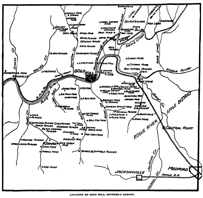 March 27, 1903 Oregonian MINING NEAR GOLD HILL
Considerable Activity Shown on Old and new Properties.
GOLD
HILL, Or., July 10.--(Special.)--The
Condor Power & Mining Company is placing a new steel wagon
bridge across Rogue River just below the Ray dam at Gold Ray.
L. T. Pockman, representing San Francisco capital, has bought the Hawkeye American mining claim in the Willow Springs mining district, and has moved a complete mining outfit out to camp with a small force to commence active development on the property. In near vicinity to this property Robert Allison and associates have taken a lease and bond on the Schumpf mine and are cleaning out and retimbering the old tunnel, from which the owners a few years ago took out several thousand dollars in free-milling ore. The Lucky Bart mine, on Sardine Creek, has been leased to J. W. Hay and partners, who are now doing considerable development work. J. M. Patrick has taken a year's lease on the Braden mine, two miles east of town, and is working quite a force of men on same. While repairing and fitting up the ten-stamp mill now on the property he has leased the Bowden mill at Gold Hill, though which he will run some 200 or 300 tons of Braden ore. This mine has produced large quantities of pay ore on the past, and as Dr. Ray has been steadily exploring and blocking out ore in this property for the past five years it now has immense ore reserves in sight, sufficient to keep the present ten-stamp mill running a number of years. The large ore bodies in this mine, in places from 15 to 20 feet in width, are found and opened to a depth of between 400 and 500 feet, thus adding another case to refute the old and well-established theory that there are nothing but "pocket mines" in Southern Oregon. Messrs. Simons and Hawley are prospecting E. E. Miner's placer ground on Karnes Creek with a view of demonstrating its adaptability for dredging purposes, and are meeting with very flattering results. Oregonian, Portland, July 11, 1904, page 4 MINING NEAR GOLD HILL.
Gold Hill--The Condor Power & Mining Company is placing a new steel
wagon bridge across Rogue River just below the Ray dam at Gold Ray.Considerable Activity Shown on Old and New Properties. L. T. Pockman, representing San Francisco capital, has bought the Hawkeye American mining claim in the Willow Springs mining district, and has moved a complete mining outfit out to camp with a small force to commence development on the property. In near vicinity to this property Robert Allison and associates have taken a lease and bond on the Schump mine and are cleaning out and retimbering the old tunnel, from which the owners, a few years ago, took out several thousand dollars in free-milling ore. The Lucky Bart mine, on Sardine Creek, has been leased to J. W. Hays and partners, who are now doing considerable development work. J. M. Patrick has taken a year's lease on the Braden mine, two miles east of town, and is working quite a force of men on same. While repairing and fitting up the ten-stamp mill now on the property he has leased the Bowden mill at Gold Hill, through which he will run some 200 or 300 tons of Braden ore. This mine has produced large quantities of pay ore in the past; and as Dr. Ray has been steadily exploiting and blocking out ore in this property for the past five years it now has immense ore reserves in sight, sufficient to keep the present ten-stamp mill running a number of years. The large ore bodies in this mine, in places from 1 to 20 feet in width, are found and opened to a depth of between 400 and 500 feet, thus adding another case to refute the old and well-established theory that there are nothing but "pocket mines" in Southern Oregon. Messrs. Simons and Hawley are prospecting E. E. Miner's placer ground on Kane Creek with a view of demonstrating its adaptability for dredging purposes, and are meeting with very flattering results. Corvallis Gazette, July 15, 1904, page 3 Jackson County.
H. Schaeffer, superintendent of the Gold Hill Dev. Co. at Gold Hill,
says work will be resumed and 200 men employed on the new electric
power and smelting plants. Josephine County.
The Oscar Creek hydraulic mines have been bought by Foster &
Gunnell of Grants Pass for Eastern men and initial payment made. The
Oscar Creek hydraulic mines are on Applegate River, 10 miles from
Grants Pass. They comprise 226 acres of mineral ground, 108 of which
are patented. The diggings are of creek bed bars, bench and rim
channel. The placers are equipped with two No. 1 giants and several
thousand feet of flume and piping and 3 miles of ditch. The new owners
will increase the length and width of the ditch, add to the water
supply and increase equipment."Oregon," Mining and Scientific Press, San Francisco, July 16, 1904, page 46 News has just been brought to Medford, Oregon, from Grayback Mountain, twenty miles east of Medford, by Wm. Gilmore, of the greatest gold strike ever made in Southern Oregon. He brought rock containing 64 percent of free gold. Harry Briggs and Charles Howard while hunting last week discovered the ledge. They were resting and picked up a small rock, which was covered with gold. They broke off a piece of the ledge cropping which weighed six pounds and mortared $700. They have opened up a vein sixty feet long and ten inches wide, exposing $20,000 worth of gold at what is claimed to be conservative estimate. The location of the strike is near the California line on a divide between the Illinois and Klamath rivers. This section was the scene of rich placer diggings in pioneer days, but no ledges were ever uncovered. "General Mining News," Mohave County Miner, Kingman, Arizona Territory, July 16, 1904, page 1 Jackson County.
Men are at work getting out timber for a complete rebuilding of the
Shorty Hope mine shaft, near Ashland, from the surface down to the
Golden Spike level. This will be a two-compartment shaft. A station
will be made at the intersection of the Shorty Hope crosscut and
necessary machinery placed at this point for sinking several hundred
feet on the ledge, which is nearly vertical. It is intended that the
shaft repairs will be completed and sunk to the Golden Spike level
before the tunnel reaches the intersection.Josephine County.
W. C. Slade, who has a placer mine on Johnson gulch, a tributary of
Sucker Creek, near California Bar, near Grants Pass, reports he has
also located a 4-foot ledge of gold-bearing quartz on his placer
claims. He has found indications of quicksilver ore deposits. A find
has been made on Sucker Creek, near California Bar, by J. Burnett. He
has two ledges running parallel. Grants Pass reports say a 5-stamp mill and equipment, formerly used at the Granite Hill mines, are being moved across the gulch to the Red Jacket claim of the Granite Hill Co. The mill is replaced at the Granite Hill by a 10-stamp battery, with four Frue vanners. The new mill has begun operations. The Red Jacket claim has several ledges of from 2 to 6 feet width, carrying values. It is intention of the American G.F. Co. to operate the Red Jacket separately, but later in conjunction with the Granite Hill. As development proceeds, the two will be united, says superintendent Wickersham. "Oregon," Mining and Scientific Press, San Francisco, July 23, 1904, page 62 J. H. Pearsons, secretary of the Oregon Securities Co., operating at Bohemia, says the tunnel which is being driven through the Champion to the Musick mine has reached a depth of 525 feet. A large amount of high-grade ore has been blocked out from the Musick mine, and by Aug. 1 the company's 30-stamp mill will begin grinding ore. The tunneling operations are being carried on through a ledge 45 feet in width. "Douglas County," Mining and Scientific Press, San Francisco, July 30, 1904, page 79 SOUTHERN OREGON MAGNIFICENT
RESOURCES
This issue of Mineral Wealth is
devoted, in the main, to that district referred to, in a general way,
as Southern Oregon. While Oregon has never attracted the attention of
the mining world as a distinctively mineral state, nevertheless, the
Eastern Oregon district, as well as the region known as
Blue River and
Bohemia, and also the district covered by this issue are today of
unquestioned mineral importance, and when compared with like areas of
mining territory elsewhere the state does not suffer by comparison.The Southern Oregon district, comprising Jackson, Josephine, and also parts of Curry counties, is, in fact. but a continuation of the Northern California mineral region, the state line passing over what promises to become some of the most important mineral deposits of the Pacific Coast. Geological conditions are not determined by artificial geographical boundaries, yet it is unquestionably true that comparatively few mining men are well enough posted on the situation to associate Southern Oregon with the mines of Northern California--the latter now by far the most prolific region of the Golden State. The location of a good mine, or a good mining district, should make no difference, save as it relates to the question of accessibility. Even though the name of Oregon is not associated with big mines as is that of California, Nevada and the various other Rocky Mountain and Coast mineral states, this fact should not mitigate against the state, but should rather create a desire to determine its proper rank in the list of metal-producing commonwealths. Happily, this attitude is now coming to prevail, and the regions named are rapidly winning a position as important mining territory. The larger mines are being put in operation, and the state of Oregon will soon take a place with her sister states as a state where the mining industry is of truly great importance. Judicious publicity is what the mining industry of the state of Oregon needs, and this issue of Mineral Wealth will, we believe, be of vast benefit to the industry in general and Southern Oregon in particular--the character and distribution of the publication assures this desideratum. Mining, as a business, is unlike other callings--particularly the mining of gold. There is no competition in this industry, the mint coins all the gold which may be offered by the miner, and there is no fluctuation from $20.67 an ounce, its coinage value. There is, moreover, a self-acceleration in gold mining that is found nowhere else. No place is the old saying more true that "Nothing succeeds like success." A miner welcomes a neighbor; the advent of a new operator in a district adds ultimately to the sum total of knowledge of the district. Geological conditions are better understood, metallurgical problems more easily solved and the cost of operation and production correspondingly lessened. Among broad and liberal operators this is looked upon as a most important and valuable means of contribution to the common knowledge of the district which in turn is used to the mutual benefit and advantage of all. To every established community in a mining region, the development and operation of a new mine is equivalent to the installation of a factory employing a similar number of people--in fact, it is of more importance, as the wage paid is, as a rule, larger, and the product of the mine is more lasting than the product of the average factory, with its benefits therefore more widely distributed. The statement that everyone residing in a mining region is interested in the welfare and progress of the mining industry is, therefore, not far fetched, and where the product consists of money metals this is doubly true. It behooves every individual to encourage the development of this great industry, and encourage also every agency organized to promote its welfare. Mining has evolved from the purely speculative, and is now recognized by the first financiers of the world as one of the most profitable fields for safe investment. The value of the minerals annually produced in the United States exceeds $1,300,000,000. The United States census shows it to be the most profitable industry of the country, producing more value per capita than do even the manufactures. This is the industry to which the chief value of Southern Oregon attaches, and the importance of that district is rapidly extending and making itself felt in the mining world. Mining regions have not always been favored by nature as Southern Oregon. The presence of mineral alone is not usually the only requisite to make the industry profitable. The surrounding conditions must be somewhat congenial otherwise, and in this respect Southern Oregon has no superior anywhere. Timber, water, climatic conditions and favorable opportunities for transportation facilities--all these are available to the operator. Within easy reach of the mines are produced cereals and fruits to feed an empire. In short, few regions are blessed with so magnificent a foundation for lasting prosperity as Southern Oregon. Mineral Wealth, Redding, August 1, 1904, page 6 Grave Creek and Tributaries
Across the divide, but in the same ridge as the Greenback, are the
Vulcan and Yellow Horn group, which comprise excellent prospects, with
ore similar to and quite as rich as that of the Greenback.VULCAN AND YELLOW HORN. Both carry tellurium. Their location is indicated on the map. The Vulcan is owned by F. Clements and the Yellow Horn and St. Elmo by Brown and Wise. The former recently erected a four-stamp mill. A claim owned by P. O. Scharingson adjoins these properties on the west and is undergoing some little development. The work so far has been in the nature of prospect work, but there is a good chance for a mine. THE MORNING STAR MINE.
One-fourth mile southeast of the town of Placer and a mile and a half
directly south of the Greenback is a property owned by C. F. Howe, and
well known as the Morning Star. It was originally discovered by J. C.
Dysert, but was bought in 1892 by Mr. Howe and C. W. Tremain, which
same year saw the erection of a Tremain two-stamp mill.The ledge is traceable for some little distance, and the principal development work consists of a shaft which reaches a depth of about 100 feet. The mine is so situated as to render operations by sinking the only feasible method. Drifts each way from the shaft bottom show a three- or four-foot ledge of ore quite well sulphuretted. The quartz lies enclosed in walls of diorite and is said to run from $5 to $15 per ton. A mile southwest of Placer is the well-known Hall group of claims, from which a number of thousand dollars have been taken out by pocket mining. The best work in this particular vicinity just now is being done on adjoining claims by J. H. Mills and Bennett & Mackin. Both have prospects that are looking up all right. The Little Dandy, owned by J. G. Hayden, is a good prospect a mile west on the same lead, and has the best arrastra in Southern Oregon. PLACER.
The post office and town of Placer is situated at the junction of Tom
East Creek and Grave Creek. The town comprises a store, hotel, school
house and a few private homes. It commands especially the upper Grave
Creek country and is the principal station between Leland and
Greenback. It is located eight miles east of Leland.The hotel conducted by Mrs. P. O. Scharingson enjoys a good patronage from the miners locally, and also from the traveling men and mining men. Mrs. Scharingson is an experienced hotel woman and knows how to look after the welfare of her guests. The store, which is owned by E. H. Wise & Co., is only a year or two old, but it has already made its convenience felt among the miners, prospectors and farmers who appreciate the opportunity of seeing what they buy, as against sending their orders off. Mr. Wise, the young man in charge, is showing his good faith by doing his share in the development of the district. He is interested with Mr. Brown in the St. Elmo and Yellow Horn claims, spoken of elsewhere. BLALOCK BROTHERS PLACER.
It should be known that Grave Creek, with its numerous small
tributaries from its source to its mouth, comprises one of
Southern
Oregon's leading placer streams. The greater number of mines comprise
immense bodies of low-grade gravel and are confined, mostly, to the
high bench or back channels along the main stream from the mouth of Tom
East Gulch down. The J. C. Lewis, the Goff, the Van Brunt (at present
under three years' lease to H. Miller), the Whitehead-Moore, the
Vindicator, the Archer, the McNeer Flat and the Harris Flat are the
principal ones from that point to the mouth, and with but one exception
are in constant operation and good producers. These mines, although all
on back channels, and probably breakovers of one and the same channel,
differ in respect to their values. Some are extremely low grade, but
are, nevertheless, good properties, because of the ease with which the
gravel can be moved; others are richer, while the Columbia, on the Tom
East Creek, and spoken of elsewhere in this issue, is the largest
producing placer mine in the county.For the first eight miles up Grave Creek, above the mouth of Tom East Creek, the grade of the stream is quite abrupt and the values are coarse and close to the bedrock. The stream here opens out into a comparatively flat area, permeated with a network of ancient channels. This basin or meadow is unquestionably the repository of untold placer gold, yet it is not worked completely with success by ordinary hydraulic methods, because of the slight grade and great depth of gravel. The back channels higher up, however, are being worked, vary readily and with good results. The principal operators here are George and John Blalock. They own 340 acres of the ground covering the higher channels. along with those of Slate, Baker, Rooth and Harris creeks, which streams also furnish them excellent water rights. The knowledge of the existence of the extensive placers on the head of this creek is not at all recent, locations having been made on this ground and the ground having been worked twenty-five years ago. Two men, John Rooth and Riley Hannum, owned two claims, which have since come into the hands of Blalock Brothers. Rooth and Hannum had equipped with a small giant and took out good pay. The gravel, however, is very compact, and Messrs. Blalock, realizing that the most profitable way in which the ground could be worked would be by the installation of heavier machinery, accordingly constructed some six miles of ditch and put on the ground 2,500 feet of eleven- to thirty-inch steel pipe and two larger giants. With this equipment and the giants operating under a 200-foot pressure, a large amount of gravel is moved each year, and in this manner the mine is made to pay very handsomely. The mine was last fall leased to other parties, but at present Blalock Brothers are operating it, with Geo. Blalock in charge. This property is not only valuable for its placer gold product, but also for its timber. Southern Oregon in general has gained considerable recognition for its timber of late, and Evans Creek, which is just across the divide from Grave Creek, has, in particular, become noted for its abundance of timber and the facilities for manufacturing and marketing. There are four or five operating sawmills on this stream and their product is eagerly sought. Grave Creek can boast of this same abundance and quality of timber. It, however, lacks as yet the facilities for marketing, because of the district's lack of good roads. THE AUTEN HOLDINGS.
Adjoining these valuable quartz claims on the south and west is the
property that will someday be valuable, and we refer to the holdings of
J. B. Auten, indicated on the map. The ground comprises most of what
was known as the old Browning Homestead, and besides covering valuable
agricultural and water rights, it almost beyond doubt contains the
continuation of the Yellow Horn, St. Elmo and Vulcan quartz ledges, as
can be seen by a study of the map.LELAND.
The town of Leland, twenty miles north of Grants Pass, on the railroad,
is the railroad shipping point for the Greenback mine, ten miles
distant, as well as a distributing point for both the upper and lower
Grave Creek country, a good portion of Wolf and Coyote creeks and the
Mt. Reuben district. It is now proposed to tap the Galice Creek
district also. At least, the Almeda Mining Company is seriously
planning the construction of a road from their mine on the Rogue to tap
the Southern Pacific railway at or near Leland, and the town of Leland
has already evinced a willingness to lend materially to any such
enterprise.It is only natural that Leland should occupy quite an Important place as a station and distributing point, and the fact is that it stands second to Grants Pass in Josephine County. Its relative prominence in the future will depend upon the encouragement and enterprise of its people and its business men are wise enough to know that it is largely "up to them." THE J. C. LEWIS PLACER MINE.
Mr. J. C. Lewis is operating two placer mines of importance on Grave
Creek, near Leland, one of which he is the owner, and the other, known
as the Goff mine, manager. The J. C. Lewis mine is covered by a
fourteen-mile ditch, the first water right of Wolf Creek, but which,
however, at present only supplies a pressure of eighty-five feet. The
deposit, which is largely of so-called old blue gravel, is sixty-five
feet deep. Its removal is augmented by drifting into the bank and
discharging blasts of powder with an electric battery. Two No. 4
monitors have a special use in helping the gravel through the flumes.The upper or Goff mine is a continuation of the lower channel of the Lewis. A sixteen-mile extension of the Columbia Mining Co.'s lower ditch gives an abundance of water under a 240-foot head. The immense bank, 100 feet in height, is being worked with two large giants and the values are caught in a long bedrock race and flume. WILSON MERCANTILE COMPANY.
Mr. Homer L. Wilson, the head and principal of the firm, is an
experienced and popular merchant. This has been his calling
for years,
or long before he left Indian Territory for this coast seven years ago.
He at that time bought a one-half interest in the business today owned
by T. J. Mackin, but selling out of that business, started for himself,
constructing in 1901 a big new store building on his own ground, a
building 100 by 25 feet. It is enough to say that he maintains a
well-equipped general merchandising store, pays especial attention to
the needs of the miners, for whose trade he makes a special bid,
carrying, for instance, a complete stock of powder, fuse and caps.STORE OF T. J. MACKIN.
The merchandising business of T. J. Mackin dates from 1894, when George
Turner established the pioneer store of the town, and with a small
stock of $400 or $500. He shortly afterward took in a partner, Mr. C.
Burnett, who succeeded to sole ownership th: following year. In 1899 D.
L. Browning, E. F. Hannum's partner in the Greenback discovery, bought
the store, but within a year sold it to Robt. G. Virtue and H. L.
Wilson. Virtue & Mackin succeeded to this ownership, and in
January, 1904 Mr. Mackin in turn became the sole owner.In these ten years the stock has grown from the small original five-hundred-dollar stock of Turner to one of that many thousands owned by Mr. Mackin. The trade of the Mackin store permeates every district above mentioned, Mt. Reuben, Grave Creek, above and below, Wolf Creek and Jumpoff Joe. The stock that occupies Mr. Mackin's shelves is a diversified stock, but one that, after all, looks to the special needs of both placer and quartz miners. Mr. Mackin has spent a number of years in this vicinity, and there is no one better posted than he on the needs of his mining and farming customers. He holds himself out as being especially able to properly outfit the prospector. His stock in general comprises dry goods, groceries, boots and shoes, hardware, tinware and such other commodities as will today be found in a well-stocked store in any mining camp. The Leland post office is located in Mr. Mackin's store building, with Mr. H. C. Ball as postmaster. Leland is the mail distributing point for Grave, Placer and Greenback, for which points there is a daily stage (except Sundays), leaving at 9 a.m. Mr. Mackin is a man whose interests extend further than the walls of his store. He is himself interested in mining, owning with Mr. A. J. Bennett the westerly extension of the well-known Hall prospect on Grave Creek, near Placer. He also owns considerable other property. He has a farm on Grave Creek, two miles above Leland, and is the largest individual property owner in the town of Leland. He is public spirited and is lending every encouragement and support to the proposed wagon roads to both Galice and Mt. Reuben. HARRIS FLAT MINE.
This mine, of which A. M. Gray is manager, comprises 160 acres of
located placer land, covering back channel ground of lower Grave Creek,
and is a property of more than ordinary interest.The ground was located by the early-day miners, and was worked by them in the ordinary way--one process of operation succeeding another. This early-day mining was, fortunately, done at a place that could not have been more admirably chosen had the old-time miners known that the ground would later be opened and equipped for the hydraulic process. Two embarrassing features in placer mining are, first, poor dumping facilities, and, second, poor water rights. The Harris Flat mine need never be embarrassed from these causes. At the present point of operations, which is also the lowest point so far reached in the mine, a natural gulch affords an excellent outlet for the tailings. A tailrace 360 feet long, and including four stretches of flume, with bedrock race and drops between that aggregate sixty feet, has a final fall of 360 feet into Grave Creek. The water right, which could be very much improved artificially, is a good one by nature, and as at present utilized, gives a pressure of 170 feet. The ground is easily worked. One inch of water will remove two cubic yards of gravel every twenty-four hours, under the present head. The bank is very high. as is shown in the picture, and seems to represent three separate channels. The first channel encountered was thought to represent the bottom, but when the opposite side was reached the rim was found to be much worn and the bedrock was suddenly found to be dipping away. Further work developed a new channel so much deeper than the first that the bedrock could not be "bottomed" with the then race. A new race had to be cut. These same conditions were repeated the past season in still another channel, which will necessitate a still deeper race. The values have improved with each succeeding channel, so that the required additional outlay will be gladly met. Mineral Wealth, Redding, August 1, 1904, pages 8-10 THE GREENBACK MINE
The Greenback mine of Grave Creek is the largest producer of Southern
Oregon, and with probably one exception, the North Pole of Sumpter, is
the most extensively developed mine in the state of Oregon, the
underground workings aggregating upwards of two miles. The
story of its
discovery, development and growth is full of interest and one that no
miner in this new district should fail to familiarize himself with.Largest Producer of Southern Oregon The history of the Greenback dates from only seven years ago--from May 16, 1897, to be exact. On that day D. L. Browning and E. F. Hannum, two young men who were at that time living near the present town of Placer, crossed over the divide between Browning Gulch and Tom East Creek, and began prospecting for a pocket. They took their first shovel of dirt from the upper bank of the Columbia Hydraulic Company's ditch, and were fortunate in getting a big trace in the first pan. In two hours they had followed it 250 feet. They lunched impatiently that day, and resuming their search, followed the trace for twenty-five or thirty feet more when at four o'clock they were rewarded by the discovery of a seam. From this seam they took out upwards of $300 in the next several days. This was a fair pocket. The seam was made up of disintegrated quartz particles, and was found to run diagonally into what appeared to be a stronger vein. It seemed to join the vein from the lower side, but was probably nothing more nor less than a breakover of the rich ledge, which in its gravitation had conveniently arranged itself into what is often called a "feeder of the main vein." The fact is that the discovery point was so near the main vein that the finding of the latter was a matter of natural consequence. Specimen ore of the richest kind was removed, and early in July the discoverers had an arrastra ready for operation. The vein was found to run almost east and west with a considerable dip toward the north, or with the surface. The pay chute was found to pitch westerly, and during the following twelve months the owners took out an average of about $2,000 per month--this from a property that had become to be spoken of as Browning and Hannum's rich "pocket ledge" on Grave Creek. The vein was opened by four levels, but the lowest was only 175 feet deep. All in all, the prospect presented such an excellent showing that it was bonded in August, 1898, by F. T. Sutherland, of Los Angeles, for $60,000. About this time it was discovered that the vein at its eastern and richer end was cut off by serpentine. At about the same time a neighboring locator had set up a contentious claim to the ground, so that the mine was finally bought by Sutherland and his associates for half the bonded figure. Tom East Creek, like Browning Gulch, is a northern tributary of Grave Creek. It is on this creek and immediately below the Greenback that is situated the Columbia mine, one of the largest of the state's hydraulic producers. It is not inappropriate at this point to call attention to the noteworthy quartz developments just now taking place up the numerous rich placer streams throughout Northern California and Southern Oregon. The surprise is that the possibilities of these fields have gone unexploited for so long. The explanation is in the fact that placer miners, after the days of the long tom and sluice in this country, preferred to go to other placer fields rather than take up with the new, and, to them untried, field of quartz mining. With the going of these placer miners went a world of valuable information which, were it only available at present, would prove invaluable in the search for pay quartz. It is enough in this connection to add that the gold of the Columbia gravel mine and Greenback quartz mine are identical in character. The purchase of the Greenback, on the part of Mr. Sutherland, was in behalf of Mr. W. H. Brevoort, of New York, and Moffat & Smith, of Denver. The corporation bears the name of the Greenback Gold Mining and Milling Company, and the control of stock is in Mr. Brevoort. The story of the development of the mine reads with interest. The year following its purchase a ten-stamp mill was built. Ten more stamps were started dropping February, 1903, and the June following twenty more, making a total of forty stamps. Last year also was added a new cyanide plant of 100 tons daily capacity. A hydraulic filter press, or montejus was also added, and is being experimented with on the slimes. Wilfley concentrators are used with great satisfaction. The camp that has sprung up about the Greenback is typical of the modern or up-to-date quartz mine, and numbers a community of 300 to 400 people. A selective influence has been exercised in the choice of employees, and the social and intellectual standard of the camp is correspondingly high. The mine itself, both in its underground works and on the surface, is operated along lines at once scientific, practical and businesslike. That is one reason of its success. Southern Oregon may well congratulate itself that this prospect fell into such efficient hands. No little of the credit belongs properly to Superintendent C. W. Thompson. As evidence of its good management, the mine is electric lighted, the drilling is by machinery; a hundred thousand tons of pay ore and more are blocked out in the stopes--a quantity sufficient for nearly four years' steady milling--and sinking from the 900-foot or mill level is being vigorously pushed with the help of first-class hoist and pumping machinery, the latter being operated by an ingeniously economical method, namely, by power developed from water brought to the pump underground from the upper mill level, 300 feet vertically above. The water is thence conveyed to the tunnel mouth and into the mill, where it undergoes a further use as battery water. As to the mine itself, its most remarkable feature is its long pay chute. Values continue uniform and comparatively high for a distance of 700 feet. This remarkable length is developed on both the upper and lower mill levels, the fifth and ninth, respectively. Up till the time the new mill started the ore averaged $16 per ton. Since then less pains are taken in sorting, and the average returns per ton have probably dropped one-third or thereabouts. The last ground above the old mill level has just been stoped out this winter, and henceforward that mill of ten stamps will be discontinued. The vein is a true fault fissure with the evidences of its fissure character very marked. The quartz itself is seldom found in well-defined ledge form, but, on the contrary, is badly mixed with filling, giving to the ore a mottled or "pudding stone" character which occurs throughout the mine. The pay matter lies mostly in the form of lens-shaped masses, usually on the hanging wall, and frequently overlapping one another. The distance between walls will ordinarily range from five to ten feet. The hanging wall is the better defined, yet the lenticular ore bodies, because of their feather edges, would often be mistaken for "feeders" but for the extreme watchfulness that is exercised to guard against being sidetracked. The geology of the mine presents an interesting problem. The ledge itself has an east and west strike and in a formation of diorite or diabase. A mass of serpentine rests against the diorite near the eastern end of the vein forming a north and south contact. The ledge, however, is cut off before the serpentine is reached by an almost vertical fault, also north and south. The fault, to be exact, extends a little east of south and west of north, with a slight dip to the northeast. It is the theory of the owners--and the theory is borne out by development to date, as well as by a study of the geology of the country round about--that the slip downward has been on the hanging wall side in which event the easterly continuation of the rich chute in the upper Greenback workings will be easily picked up by drifting along the line of the fault unless the slip has been too great. That the slip has not been very great seems to be indicated by the development of the ninth level. Here the tunnel was driven easterly far enough beyond the fault to show that the serpentine had receded to a point considerably easterly from where it had been encountered between the eighth and ninth levels. Mr. Thompson is so sure that they have reached a depth below the serpentine that he intends drifting from the eleventh level in an attempt to pick up the lost chute. This effort will be watched with interest by mining men. Drifting on the vein from the eleventh hundred-foot point of the winze is already being prosecuted in both directions. At the tenth hundred-foot point a station has just been completed to facilitate pumping and hoisting. The lowest point in the mine is already fifty or seventy-five feet below the bed of Tom East Gulch. Besides the Greenback proper there are seven veins in various stages of development on the group comprising the property. None, however, has been very extensively opened up. Of these the Irish Girl is the most promising. It lies south of the Greenback 150 feet, and is parallel to it. The walls are from three to six feet apart, and the values lie principally in small stringers of high-grade ore, carrying value, occasionally, in combination with tellurium. A promising vein shortly north of the main Greenback is just now receiving some active attention. It is showing up well and the company puts considerable faith in it. A noteworthy feature of the Greenback ore has been its tendency to show great richness in spots, while at the same time carrying regular values throughout its long pay chute. The gold continues free, handsome specimens are found in the lowest levels. The 200-foot winze sunk from the mill level gives a total depth on the vein of 1,100 feet, yet the proportion of gold saved on the plates at this lowest point is as large as ever. In other words. the ore is distinctively a quartz ore, the sulphurets rarely constituting more than one percent of the total. The Greenback in the true sense is pioneering the quartz mining industry in Southern Oregon. It is a property which, although hardly started on its career, yet would be a credit to any of the older established mining camps. It stands among that rare class of quartz mines that have paid from the grass roots down, and its output to date--approximately $750,000--entitles it to rank with the first-class mines of the country. Mineral Wealth, Redding, August 1, 1904, pages 10-11 WOLF CREEK MINES.
A formation very favorable to the existence of gold-bearing quartz
ledges in both Southern Oregon and Northern California is one that on
the surface shows up in the form of a soft red or yellow rock. It is a
formation for which the average prospector naturally has quite a
failing, and one which, for want of a better name, he conveniently
calls "porphyry." In reality it is nothing more or less than the
weathered or oxidizedSCRIBNER-HENDERSON. capping of one or another of the various formations of diorite or diabase, with which the country abounds. Occasionally, the diorite appears in a narrower width than at other times and is spoken of as a porphyry "dike." Some of these diorite belts are literally seamed with small gold-bearing quartz veins. It is not unlikely that there will be found among these bodies of diorite some whose weathered surfaces will prove sufficiently high grade to warrant some method of reduction. As a matter of fact, it is today not an infrequent thing to find their surface sluiced or hydraulicked for its gold-bearing contents. The gold gathers in rich seams after having been freed from the quartz by the oxidizing processes, and it is from these seams that some of the greatest pocket finds have been taken. The richness and frequency of these pocket seams might furnish a pretty accurate criterion as to what the unoxidized diorite beneath is capable of producing, save for the fact that in addition to the weathered portion of the formation which today contains this gold we must allow for the formation previously worn away, all of which has left behind at least a part of the yellow metal it once contained intact. The richest of these diorite bodies personally visited and inspected by a Mineral Wealth representative is the Scribner and Henderson ground at the head of Wolf Creek, now under option to Mr. J. C. Dysert. The two prospectors who gave it its name traced up a number of seams, and are said to have hand mortared and washed out $35,000. The whole surface yields a heavy trace of gold. A large number of seams have been opened up at various places on the property, and many others will, no doubt, be uncovered from time to time. Mr. Dysert took charge of the property last summer and constructed a well-built double tub arrastra, and since that time has operated the same profitably and to very good advantage in every way. The porphyry of the Scribner and Henderson mine is about a quarter of a mile wide, extends northeasterly and southwesterly, and lies between a formation of serpentine and slate, the serpentine lying on the southeast. The porphyry or oxidized part of the diorite is from twenty to forty feet deep apparently and will average quite well in free gold considering the amount of tonnage in sight. A good grade of sulphuret also is saved in the arrastra. The mine will be operated by surface stoping on exactly the same lines as the now-famous King Solomon porphyry dike that has produced so phenomenally in the past half dozen years, on the south fork of Salmon River, Siskiyou County, California. On the Scribner and Henderson property a tunnel 180 feet long has been run to cut a ledge that parallels the serpentine near the point of contact. The tunnel is not yet quite complete, but offers a most excellent opportunity to sample the diorite for its average value. The showing made by this tunnel and the various openings on the surface are surely such as to invite investigation, especially in view of the equally good showing made by the Sluter mine a mile northeast or on a continuation of the same formation. A large iron dike, averaging, perhaps, twenty feet wide, lies along the serpentine-porphyry contact, and a gold-bearing quartz ledge a foot or fifteen inches in width lies just north or immediately below. This ledge has been thoroughly opened up at a point easterly of the Scribner and Henderson holdings, and shows up to very good advantage. A good chute of ore is laid bare. The property is indicated on the map and is owned by J. B. and E. F. Hannum. SLUTER MINE.
This property, owned by H. D. Sluter, presents a duplication of the
conditions of the Scribner and Henderson mine. The surface showing is
the same, the diorite has the same width, namely one-fourth mile; the
serpentine still continues as the "hanging wall," and the slate
formation to the northwest might be designated as the "foot wall." Even
the iron dike and the Hannum quartz ledge both still hug the
serpentine. The quartz ledge has yielded some fine specimens. A
thirty-five-dollar piece was taken from the very summit of the Wolf
Creek divide.The Sluter placer mines, which compose part of the Sluter holdings, lie on Sailor's Gulch, which is a northern tributary of Wolf Creek. During the eight years he has mined this gulch, Mr. Sluter has piped away some 750 feet of the ancient channel formation that formerly lined this stream. The gold is heavy. Nuggets have been found weighing from $20.00 to $50.00. Mr. Sluter has realized an average of $10.00 for every foot length of the stream bed and has done this in spite of the fact that he was compelled to leave unworked a good bit of the lower ground because of a poor dump. These placer mines were unquestionably fed by the gold from the porphyry or decomposed diorite of these upper Wolf Creek properties, for, no gold is found above the serpentine-diorite contact. Mr. Sluter has found the same rich seams that are found on the Scribner and Henderson property. From one of them he took out over $4,000 in less than three months. Mr. Sluter a year ago last winter turned his giant upon a small area of the decomposed diorite, and while he was unable to save much of the gold because of the obstinacy of the porphyry in disintegrating, yet the experiment was of value in showing up quite a surface of the formation, and the seams that enter into its composition, and it furnished him, as it were, a cross-section of the geology. The Sluter holdings of 100 acres of the porphyry formation and the Scribner and Henderson holdings of 120 acres are separated, as indicated on the map, by a similar property owned by Brown, Cabel & Co. WOLF CREEK MINING AND DEVELOPMENT
CO.
The Wolf Creek Mining and Development Co. owns 160 acres of placer
ground and four quartz claims on Wolf Creek and Hole-in-the-Ground
Creek in the Wolf Creek mining district, Josephine County, Oregon.This is an ideal district. The region is heavily timbered and contains an abundance of water. This company owns excellent water rights. Arrangements are now being made to extend one of the ditches to the lower portion of the placer. It will cost only a comparatively small amount to build this ditch and when it is completed the company will have sufficient water to operate two large giants the greater portion of the year, and will have sufficient gravel ahead of them to keep the giants at work for fully twenty years on good ground without the further expenditure of another cent for the building of ditches, etc. The channels are sixty to one hundred feet wide, with a depth of four to six feet, and contain values of from twenty-five cents to seventy-five cents per cubic yard, and, in some places, yields as much as $2.00 per yard. The gold is mostly of a coarse nature, and many large nuggets have been found. Messrs. Wilson and Rickard, who are working the claim adjoining this property on Hole-in-the-Ground Creek, picked up a $17.00 nugget a few weeks ago. Pieces of the value of $2.00 to $10.00 are very frequently washed out in these old channels. A $1,220.00 nugget and another of $700.00 was picked up years ago by the oldtimers. There are portions of ancient channels on this company's placer ground that have never been touched, even with pick and shovel. Some of the more accessible parts were worked in early days and they yielded big money with the old-time sluices. With the modern hydraulic equipment that the Wolf Creek company will have installed for the coming season, every inch of this ground will be washed and handsome returns should be the result. The company also owns several good quartz claims.They are located on the head of Hole-in-the-Ground Creek, a tributary of Wolf Creek, about a mile above the placer property. There is an abundance of water and timber for mining purposes. These claims are located on the rich mineral belt running through that section of the country and are not more than five miles from the Greenback. It is conceded by mining men who are familiar with that section that the lead on which these claims are located has been the feeder for all the rich placer ground below it. Sufficient development work has been done on the quartz to demonstrate its value, and the tunnel now being driven is in ledge matter fifteen feet in width and the footwall has not yet been encountered. Both the quartz and placer ground are easily accessible. The county road runs through a portion of the placer and within a short distance of the quartz. The company is now selling a small block of the treasury stock for the purpose of equipping and developing the property as outlined above. M. B. Bozarth, 251 Alder Street, Portland, Or., is the secretary and manager of the Wolf Creek Mining and Development Company. The other officers are prominent professional and business men of Portland, Astoria and Salem. A DRIFT MINE.
Besides the placer properties of the Wolf Creek Company and
H. D.
Sluter, Lehman Brothers control 1,100 acres or so, which they are
working by drifting. J. C. Rickert has a claim adjoining. The present
channel was worked years ago. The present owners located it for the
same purpose thirteen or fourteen years ago, but after a year or two
they ran into a formation of gravel projecting into the present channel
from the north side, and on a brief investigation satisfied themselves
that the ground was rich and commenced drifting. This was a
surprise to
the old miners, who never suspected a back channel. The gold is quite
coarse, pieces as large as twenty dollars and more being found. A drift
mine needs no recommendation as to its hydraulic character and it
really would not require a great outlay to transform the Lehman
property into a hydraulic mine.Mineral Wealth, Redding, August 1, 1904, pages 12-13 THE RUBLE MINE AND GRIZZLY.
This mine is situated on Coyote Creek, which flows into Wolf Creek at
the station of that name on the Southern Pacific railroad, thirty miles
north of Grants Pass. Coyote Creek was one of the best streams of the
country in the early days.THE RUBLE MINE. The Ruble mine, owned by Ruble & Sons, comprises a consolidation of a number of former smaller properties, and is known to be a mine of good value. The one detractive feature has been the lack of natural dump, since the grade of the stream is very small. Then the water, too, is scarce for the ordinary methods of hydraulic mining and the material is quite heavy, there being many good-sized boulders. During six years of the mine's operation the present owners took out a total of $65,000. The property includes much virgin ground, and represents an ideal opportunity for a still further consolidation on the part of larger capital, this larger organization to provide for larger water rights and more extensive equipment in other ways. Mineral Wealth is in a position to state that these holdings could be secured on a reasonable basis. That they represent one of the best openings in Southern Oregon for a big hydraulic mine is a statement whose truth will become readily apparent on even a casual investigation. THE RUBLE GRIZZLY.
The slight grade and the limited water supply of the Ruble mine
involved a serious problem in that mine's operation. The owners were
driven to various experiments to meet the difficulties and since the
large boulders rendered hydraulic elevating out of the question, it
almost looked as though much good ground was destined to remain
unworked. After some experimenting, the Rubles finally hit upon a
process ofelevating, all their own. They constructed an apparatus consisting essentially of a grizzly and undercurrent over which the gravel is forced by means of ordinary hydraulic giants and the results have been very satisfactory. It was by this means that they were enabled to remove the above amount of money in the time named as stated, and from ground which, under other circumstances, would have been worked at a very great cost, if worked at all. The process of operating is simple enough. The material is forced over the grizzly, as shown in the picture. Boulders, stumps, roots and logs alike find a common dumping place beyond the "stacker." The finer material is screened from the rest in transit through the appliance and is sluiced off through an elevated sluiceway on the opposite side of the grizzly. It is in these sluices that the gold is saved. The Ruble elevator is a device whose merit has been fully proven, which is amply attested by the eighteen or twenty grizzlies which are in use in the various districts of Southern Oregon. Mineral Wealth's representative found them giving good satisfaction wherever they were being used. Mineral Wealth, Redding, August 1, 1904, page 13 JUMPOFF JOE CREEK MINES
Mineral
Wealth, Redding, August 1, 1904, pages 14-16ORO FINO MINE.
Mineral Wealth
is glad for the opportunity of giving the public some notion of this
promising young property, situated, as it is, in the heart of a
promising district. We are glad, moreover, to point out so instructive
an instance of what cautious, painstaking work will do toward the
development of an embryo mine.
The Oro Fino, like nearly all other Southern Oregon ledges, was free milling on the surface. The values, on the other hand, occur finely disseminated throughout the quartz instead of being concentrated in specimen-like quantities, so that at the present depth free gold is rarely ever seen, even in rock of the highest quality. The Oro Fino was discovered at a point about forty feet north of what is today being shown to be the main vein. The present workings show this discovery to have been only a branch of the main vein, although it produced from $18,000 to $20,000. Since Mr. S. Chase took hold of the property a year ago he has demonstrated beyond a doubt the separate entity of these two veins. In fact, what has been shown is this, that the Oro Fino proper is only one of three or four veins, all of which, as they descend, approach a distinct and separate vein--joining it from its northerly or footwall side. This main vein, previous to Mr. Chase's ownership, had been struck by a 140-foot crosscut tunnel, and followed with a drift for a distance of 333 feet. It was noticed that there was some little difference between the character of quartz at this place and the quartz above, but the cause for this difference remained for Mr. Chase to disclose. From the 333-foot point on the drift, a crosscut to the right or north was run to connect with a shaft from the old workings above, the object being to get air. This shaft, as subsequent development has shown, went down on another one of the feeders. Work on the main drift was resumed, and at a point sixteen feet beyond the 333-foot point a seventy-one-foot winze was sunk. At the bottom of this winze a strong ledge of good average ore, six feet wide, was disclosed, but in the drift things did not show quite so encouragingly. The ledge had given way to a bare seam and a displacement of waste matter. Attention was transferred to the tributary vein just mentioned, or on which the old shaft had been sunk. This vein was followed southwesterly on an angle that would have brought it to the main vein in a distance of 100 feet or so, but it in turn narrowed to a small width and was given up at a point ninety-four feet from the shaft. This was in 1902 and represented the last work done on this level in the mine until taken hold of by Mr. Chase and associates. After a study of the situation Mr. Chase decided to crosscut southerly for the vein. He believed that the vein could be found in place, and his hypothesis proved correct, for at the end of only nineteen feet of crosscutting the expected happened, for the vein was encountered. Since that time the development of the Oro Fino has been a simple, persistent, steady, unfolding process, with the result that today it stands as one of the country's best prospects. After intersecting the vein, a drift was pushed westward fifty-five feet, every foot of which was on good ore--in fact, some of it very high grade. A winze was sunk sixty-five feet in depth, every foot on good ore, showing a fine two-foot vein of unmixed high-grade quartz. The drift itself has been continued westward for sixty feet, the whole length of which and the face of which are both on a fine-looking ledge of good ore. The hanging wall is well defined, while the footwall is becoming more so as it gets down beyond the zone of feeders or branch veins. A fifty-ton daily capacity cyanide plant is at present being installed. A Boston crusher and Sturtevant rolls will be used to reduce the ore. Development at the Oro Fino will be watched with keen interest. BABY AND GOPHER.
These properties, which form with the Cosmopolitan a compact group, as
indicated on the map, are both prospects with interesting records to
their credit, as well as promising assurances for their future. They
have the good fortune of being in the hands of good companies. Both
happen to be California companies. The Baby is being developed by the
Capitol City Mining Company, of Sacramento, C. C. Higgins as manager at
the mines. The Gopher, with headquarters at San Francisco, is
represented at the mine by T. E. Lacy.Both properties are equipped with two-stamp mills. Both have yielded considerable from high-grade rock, especially the Baby. The work of both at the present time is in the nature of prospecting. At the Gopher there is being run a long crosscut tunnel to tap a mammoth ledge of quartz ore in the hope of striking a pay chute. This tunnel is now in over 700 feet. The ledge where exposed on the surface is low grade. THE HAMMERSLEY MINE.
This noted prospect, after a turbulent career of twelve years, is today
under bond to the Willis & Osgood Company of Seattle, who,
after
unwatering it, are today doing the first systematic development the
mine has seen since its early days. The mine is so situated in a
depression of the mountaintop as to make sinking and hoisting the mode
of operation. It is on the divide between Jacques Creek and Brass Nail
Gulch, on the upper Jumpoff Joe, and as indicated on the map. It has
produced $75,000 to $100,000, and is esteemed as a prospect of
excellent promise.LUCKY QUEEN.
This property, whose situation is given on the map, is owned by
Corliss, Rush & Son, but at present under bond to G. Trapschuh
and
associates of Spokane. It is thirty-five years old, being among the
first quartz locations in the country. Twice has it witnessed the
construction and removal of a five-stamp mill, and large quantities of
high grade rock have paid for expensive mining, hauling and shipping.
The tunneling and shafting will aggregate 2,000 feet.The new company has done considerable development during its ownership of the past year, and has commenced the construction of quite a long tramway and ten-stamp mill. Mr. C. D. Crane is manager. THE COSMOPOLITAN.
The Cosmopolitan group of mines, formerly known as the Little Dick
group, is situated on Bear Mountain with such mines as the Baby and
Gopher on its southern extremity, and the Lucky Queen mine just across
Jumpoff Joe Creek on the north. It stands distinctly in a class by
itself. In respect to the character of its ore it differs widely from
that of the mines just mentioned, and as regards size, it is not
equaled in the district.It consists of three quartz claims and eighty acres of railroad land, and was purchased by the present owners, A. G. Minter of Seattle and August Fetsch of Grants Pass last fall. They bought the ground from Jacob Meier, who likewise secured it by purchase three years ago from J. C. Dysert. The work, prior to the sale, was very much along the line of surface stoping. The oxidized ore near the surface was quarried out and the finer material was screened and conveyed to the bottom of the mountain, for a distance of 800 feet, by washing it through a V-shaped flume. The ore was treated with a twin-tub arrastra, built by Mr. Dysert, and by this method would give a gross return of over $4.00 per ton. When Mr. Minter assumed control he set about to open the property more extensively. He ran a crosscut of 150 feet west and tapped the vein at a depth of 100 feet, touching the footwall first. The length of this crosscut was through diorite, at first soft and easy of removal, but as depth was gained the rock became more and more hard, and when the ledge was struck the diorite had almost the hardness of flint. The course of the vein is northwest and southeast and dips southwest or into the hill. The crosscut was continued in the ore for twenty feet and the other wall has not yet been reached. The ore is a peculiar mixture of quartz and diorite, with also a great deal of lime. The values at this depth are mostly in the sulphurets and the method of treatment will no doubt be by cyanide. A one-and-one-half-mile ditch, tapping one fork of Jumpoff Joe Creek, brings water to the ground below, and affords an excellent opportunity for a reduction plant. There is an abundance of timber on the ground for mining and building purposes. JUMPOFF JOE HYDRAULIC
MINE.
Seven miles up Jumpoff Joe Creek from Merlin, on the tributary known as
Jacques Creek, is a consolidation of mining ground controlled by
Dysert, Keyes and Booth. It comprises 758 acres, of which 548 acres is
deeded ground. The nucleus of this area consists of about 500 acres
consolidated by J. C. Dysert in 1895 out of four separately owned
properties. The first year of the Dysert ownership, Mr. Dysert
constructed a three-quarter-mile ditch from Jacques Creek and, fitting
up with pipe and giant, mined the property in this way for the first
time. The present channel of that tributary of the Jumpoff
Joe had been
pretty well worked, at least, below its confluence with Horse Creek,
and in order to tap the old back channel it was necessary to cut a
bedrock race 600 feet long. The gravel was eighteen or twenty feet deep
and ran from fifteen to twenty cents per cubic yard. It was seen that
the plant was inadequate for the amount of ground to be worked away,
and accordingly, in 1898, Mr. Dysert commenced the construction of a
large ditch tapping Jumpoff Joe Creek, to be about five miles long and
having a capacity of 2,000 inches. Two miles had been completed when a
company of four San Franciscans formed a partnership, bonded the
property and completed the ditch in six months, employing at one time
as many as 150 men. But the ditch was finished too late for much of a
season, and six months more saw the partnership divided in some matters
of policy, with the result that the possession and ownership was
allowed to revert to Mr. Dysert.Early in 1903 the property was bonded to Jos. Clark, of Los Angeles, brother of Senator Clark, of Montana, who made a cash payment of $5,000 and fitted the mine up with additional pipe, giant, electric lights, etc., bringing the equipment up to four giants. Jos. Clark died during the summer and his personal representatives failed to close the bond. Besides several thousand feet of pipe, there are all told about twelve miles of ditches, including a bywash ditch of 800 inches capacity, also out of Jumpoff Joe Creek. The mine is opened up at two places. At the lower point or near the mouth of the creek there is little grade, it having been necessary to cut a 1,300-foot race, flumed for most of the distance with four-foot flume. But the giants here can be worked under a 400-foot pressure. As you go up the creek the grade increases rapidly until at the upper mine the dumping difficulties become merely nominal, the freshets of the creek acting as a flusher for the tailings. The pressure of piping, however, is less than half of what it is at the lower mine. The lower mine offers ideal conditions for hydraulic elevating. The J. O. Booth claims of eighty acres and the farm of H. M. Gorham lie below the property on the Jumpoff Joe and are supposed to comprise equally good ground. The property during the past season was under lease to Wallace and Hasty. SOUTHERN OREGON MINING AND
DEVELOPMENT COMPANY.
The Southern Oregon Mining and Development Company of Portland are now
operating one of the richest placer mines in the Southern Oregon field,
and it is a property that has an established record for its high values
in gold.This ground was first located in 1862 by Henry Wines, an erratic Prussian, but who was the pioneer miner of this district. The property, as it stands today, consists of a strip of land one and three-quarters miles in length on Jumpoff Joe and Bummer creeks, and the pay gravel for this entire distance is from 100 to 600 feet in width. The bank ranges from four to fifteen feet in depth. These conditions have been determined after careful prospecting. It is an economical mine for operation. The water supply is good and the dumping facilities are ample. It is a mine that can be worked as heavily as its owners may choose and obviously has years of operation before it. The present owners purchased the mine from C. D. Sexton, who has operated it every season for the past nine years, and whose cleanups have always been more than satisfactory. The gold is coarse and heavy, averaging $18.50 per ounce. Mr. Sexton has kept a number of souvenir pieces ranging from $2.00 to $180.00. This property had been in the eyes of old-time residents here for years. Wines was a very eccentric man; some charged him with being a hard old customer; others found him a generous, kindhearted old chap. No prospector who had "gone broke" and showed up at Wines' cabin was ever refused a welcome or a helping hand for a fresh start. Wines was known to have considerable gold always in his possession, mostly in large nuggets; his smaller gold he would sell to get his supplies. About ten years ago he had two men in his employ. It is claimed by these men that he finally grew sullen and that they feared that their lives were in danger at his hands. They watched him, and one evening, it was claimed by them, he attempted to take their lives. They, however, were quicker than he, and he was killed instead. These men were tried for murder and acquitted, but many of the residents and miners in the camp still think that the old man was murdered for his money. It is conjectured that his gold is still left where he hid it and will some day be unearthed. The present owners of the property have been operating this season on merely a prospective scale. It is their intention to equip it thoroughly for next season's run, and from past experience they are justified in expecting a big cleanup for the coming year. THE MT. PITT COMPANY.
A mining deal of no little importance was recently consummated in which
a part of the former holdings of Cook & Howland became the
property
of the Mt. Pitt Hydraulic and Quartz Mining Company, composed mainly of
Portland men. The company is incorporated under the laws of the state
of Oregon, and is capitalized for $50,000, with headquarters at
Portland, Oregon, 226 Failing Building. The directory is represented by
E. House, president; D. L. McCloud, secretary and treasurer,
and A. C.
Hoofer, one of the original discoverers of the St. Helens field,
Washington, as superintendent and manager.This promising property comprises 125 acres of valuable placer ground on Bummer Gulch, tributary of Jumpoff Joe Creek, Josephine County, and two quartz claims immediately on the line between Jackson and Josephine, and in close proximity to the placer. The present equipment of the placer is rather meager, but it is the policy of the present management, after some preliminary prospecting, to install an equipment adequate to handle the great deposits of rich gravel. A ditch of one mile will supply abundance of water from the gulch under a pressure of from 175 to 200 feet. The nature of the gravel is old channel deposit, and if indications count for anything, the owners are justified in their sanguine attitude toward their present holdings. The channel is no doubt a continuation of that of the Southern Oregon Mining and Development Company, and also the Cook & Howland. It is located less than two miles from the latter well-known property and adjoins the former. Former owners who were content to operate this ground in an unsystematic and haphazard manner obtained results that were far from being unfavorable, the upper end of the ground paying $7.00 per day with a rocker. The values are of a very coarse nature (one piece having been found on the lower end of the property that weighed $110.00) and are scattered throughout the bank, which is from ten to fifteen feet in depth. Just across the line in Jackson County the company owns two quartz claims, located on the same vein, and of these the company is, and has a right to be, very hopeful. The vein has been traced for a great distance on the surface and by pan prospects the most flattering results have been obtained. The ledge has been opened and discloses a vein five feet in width, gives returns by assays of $30.00 per ton in free gold, and will soon be tapped by a crosscut tunnel, now almost complete. About the middle of June or several weeks after our representative visited this mine, the Mt. Pitt Company struck their ledge. They struck a big body of high-grade ore. Part of the rock was exceedingly rich, and for the whole ledge, or for a width of ten feet, will pay well to mill. They have gained from 50 to 60 feet of back with a 90-foot crosscut. BRASS NAIL GULCH.
On this gulch, above the property of the Southern Oregon Mining and
Development Company, are properties owned by Hillis & Collins,
Thompson & Schroter and Bennett. For several months in the year
there is a good head of water from Brass Nail Gulch itself, and some
very heavy gold is found--one piece weighed $245.00.J. W. Robinson, now of Crook County, is said to have taken out $25,000 to $30,000 in his six years of ownership. THE GRANITE HILL MINE.
A
scene of great activity is the Granite Hill mine, on Louse Creek, the
property of the American Gold Fields Company. The mine was purchased by
this company about two and one-half years ago and has in that time
undergone almost phenomenal development. Modern equipment has
superseded the primitive methods in vogue; development work has been
constant and systematic; and all in all, the property bids fair to
become one of the state's best.Its history up to the time of its purchase by the present owners was not entirely unlike that of its contemporaries. The development was desultory at best and there were frequent changes of ownership. It finally in 1899 came into the hands of Mr. C. L. Mangum, who, at once setting about to inaugurate a systematic line of policy, interested with him such men as A. J. Hechtman, H. Fleishhacker and F. H. Buck, of California, and R. A. Booth, of Oregon. J. O. Booth subsequently obtained an interest. The holdings of the American Gold Fields Company cover more than 700 acres of area, and the placers on this ground were worked in the early days by the comparatively ineffective methods employed by the early gold seekers. After the richest had been worked by pick and pan, the ground was successively worked by the long tom, by ground-sluicing and by drifting. These various methods were each in turn employed with great success for a considerable time. The mine, however, failed to see any improvement in modes of working until twelve or fifteen years ago. This was no doubt due to the fact that it could be so successfully worked by the simpler methods. So that it was in the early nineties before a hydraulic equipment was added. This progressive step is to be accredited to M. F. Hull, W. S. Beck and Pelton Brothers, who at that time owned the ground on the south fork of Louse Creek, or what is known as the "Upper Diggins." C. N. Matthews and W. T. Turnham owned the ground at the junction of the three forks and they still continue to work it by drifting and ground sluicing. The gold in the placer of the south fork is local wash and was unquestionably deposited by erosion from the gold-bearing veins of the surrounding mountains. This was, however, not universally conceded by the placer miners working on the stream, till what is called the Bed Rock vein was exposed, by washing away the auriferous gravel which obscured it. The eyes of the miners were thus opened to a new field of mining and they constructed an arrastra, by which means they took out $8,000 from the Bed Rock vein. This gave an impetus to a new industry, and the possibility that Louse Creek would become a quartz mining camp led other placer miners to discontinue their calling and search for pay quartz. Other veins of promise were accordingly discovered and more arrastras were built, so that when Mr. Mangum secured the ground in 1899 and effected its consolidation, there were three arrastras and one small stamp mill on the ground that has later all been acquired by the American Gold Fields Company. Running east and west through the property is an ancient blue gravel channel 150 feet wide and from 40 to 50 feet deep, and this represents the nucleus of the company's placer ground. This is now covered by eight miles of ditches, representing the first and entire water right of the three forks of Louse Creek, and the necessary pipe and giant equipment. Four of the numerous veins on the holdings of the present company were discovered and partly developed when Mr. Mangum secured the ground; two more were discovered on the patented lands of the company and one on public land, which was accordingly located. There are seven distinct veins on the property in various stages of development. The veins, which are evidently true fissures, occur in two formations, viz., granite and diorite. The contact passes through the center of the property and has an east and west strike which is parallel to the strike of the Granite Hill vein. The strike of the High Tariff and Red Jacket veins, on the other hand, is nearly north and south. However, all other veins thus far developed on the property run east and west. Again on the northeast and lying smoothly against the granite is a dike of highly mineralized diorite, these three formations being in close proximity and their lines of contact parallel. During the time of Mr. Mangum's management the property was more thoroughly and consistently opened up than it had ever been before. A latest improved Wilfley concentrator was added to the equipment, which at that time was a small 5-stamp mill, run by steam. Underground work was pushed forward, and all in all, Mr. Mangum and associates expended some $12,000 in developing, and by the legitimate disposition of this amount the property presented such a creditable showing that it was purchased by W. J. Morphy, of Chicago, for the American Gold Fields Company, of which he is manager, about two and one-half years ago. Walter de Varila, who was superintending operations for the company at that time, commenced sinking the shaft on the Granite Hill vein. An engine and small hoist were installed and this work was vigorously prosecuted. Later L. B. Wickersham succeeded Mr. de Varila, and he has continued to work out the policy of the company. The shaft was a vertical, double compartment, five by six feet in the hoisting compartment, and five by two and one-fourth feet in the manway, and this shaft was down 107 feet when Mr. Wickersham took charge. A change was thought necessary in the construction of this shaft and was brought about by Mr. Wickersham by putting the spreader in the center of the shaft, thus making two equal compartments and giving sufficient room for the pump and air line in the manway.and ample room for the cage in the other compartment. The shaft was continued for fifty feet further before the ledge was struck, and here was encountered a chute of ore which was heavy in galena, and free gold in close proximity to the galena. A mill run of 100 tons at this point gave returns of $9.00 on the plates. On the 207-foot level a station was cut in the shaft and drifts run both east and west on the vein, aggregating about 400 feet, in which the ledge showed as strongly as it did in the upper or 107-foot level. In the west drift a chute of galena ore has been struck, of the same character as that encountered in the shaft in the sinking. The values are pleasingly high grade, and the ledge is from three to seven feet in width, with the pay ore mostly on the hanging wall. It is the policy of the company to carry the drifts steadily forward, raising on the chute to the level above, thus ensuring good air and ventilation. At a depth of 230 feet in the shaft a subterranean watercourse was struck, occasioned by a flat slip crossing the formation which allowed considerable water to come into the shaft. To overcome the difficulty of sinking against this influx of water, a number 9 Smith-Vaile pump was installed and a crosscut driven twenty feet north from the shaft and having the same width. At the end of this solid ground was struck, and a sump, capable of holding 10,000 gallons of water, was cut. The station was well timbered and electric lighted; then the big pump was swung from the shaft into the pump station. In this way, practically all the water entering at this point and from above is caught up and pumped to the surface, thus keeping the water away from the shaft and obviating the necessity of having to pump this influx from the lower levels. A small Worthington pump is hung in the shaft to take up any water that may accumulate in the bottom. This work has solved the water problem and enables sinking to be carried on vigorously. The shaft is now going down rapidly and its continuation will be carried on in conjunction with the driving of levels and connecting with raises, it being the intention of the company to carry this shaft down at least 600 feet at once, developing each level from the shaft as it is reached. The company has installed a hoisting plant, which is one of the finest in the state. It is of the double drum, twin engine type, and capable of carrying the shaft down 2,000 feet. The drums are six feet in diameter and the whole plant is set on piers of solid concrete ten feet in thickness. An inch steel cable is used hoisting over a forty-foot head frame and carrying a cage which can be converted into a "double decker," handling timber, men and loaded ore cars carrying 1,600 pounds of ore. The new mill has just been started. It is a model structure and deserves more than casual description. The stamps are of the well known Allis-Chalmers make. The ore cars wheel into the top of the mill from the collar of the shaft and dump into bins of 200 tons capacity. A drop of seventy feet is afforded from the bin to the concentrating floor and an excellent grade has been provided for an automatic run of ore from the time it leaves the shaft till it is impounded in the tailings. The stamps, as has been stated, are of the Allis-Chalmer type, provided with hanging feeders. A crusher of eighty tons capacity is stationed at the top of the lower ore bin. Six-foot Frue vanners are used, there being four in the mill at present. The mill is spacious and well lighted, being provided with electric lights. A 100-horsepower boiler supplies power for the plant, which will be augmented by one 75 horsepower, which is now being installed. A six-drill Ingersoll-Sergeant air compressor has been set up in the power house adjoining the mill delivering air through a three-inch line to the shaft and levels. With such an equipment, as regards hoisting, air compressor capacity and a complete solution of the water problem, the Granite Hill is in excellent shape to ensure a rapid development. The Red Jacket claim deserves more than a passing notice. It has been opened up by a tunnel driven over 250 feet in length, crosscutting three well-defined veins, with a rich pay chute of eighteen inches to two feet in thickness. Two of these veins, parallel, are only eight feet apart and dip toward each other and undoubtedly will unite soon and form a large body of high-grade ore. A winze being sunk on the vein discloses a fine body of high-grade ore, and the boiler, hoist and compressor formerly used on the Granite Hill mine are now being installed with a view to extensive development work. The owners of the property believe that the Red Jacket will prove to be one of the richest mines in Southern Oregon and propose to open it up on a scale commensurate with its merit. A sawmill in connection, with a capacity of 6,000 feet of lumber per day, is located 200 yards from the mill. All the lumber for the buildings and mine has been sawed out at this place. The company's holdings in the vicinity have an abundance of timber of the celebrated Douglas fir variety, which in its qualities of strength, toughness and elasticity is unexcelled. This settles definitely and favorably the problem of mining timbers at the Granite Hill for all time. The camp has an excellent mess house, and it is the intention of the company to erect a number of small bunk houses on the north fork of Louse Creek, each to accommodate four or five men. These will replace the ones now being used. The superintendent's office and the assay office and laboratory are situated about 100 feet from the new mill. All in all, the Granite Hill mine represents at the present moment the most interesting quartz development in Southern Oregon. The Greenback is too well established to excite any unusual interest, and the Benton, Opp and Braden are still all unequipped. The creditable showing at the Granite Hill is due to the efficient management the mine has had at the hands of Manager W. J. Morphy and Superintendent L. B. Wickersham. FOREST QUEEN MINE.
On Louse Creek, and adjoining the holdings of the American Gold Fields
Company on the west, is the conveniently located and fitly named Forest
Queen mine.Last October this property passed into the hands of J. B. Pipes, a practical miner who has extensive holdings in lead and silver mines near Wardner, Idaho. Mr. Pipes purchased the interests of two of the former owners and has the remaining interest under bond and lease. This property, while at one time a great producer, is just at present undergoing exploration for the purpose of determining the location of the pay streak, which was completely lost while under the management of owners previous to Mr. Pipes' purchase. This property, comprising 213 acres of patented land, covers both the present and ancient channels of Louse Creek for a distance of two miles or more. A two-mile ditch from Louse Creek supplies the ground with 2,500 inches of water. Two 800-foot pipe lines giving a pressure of 225 feet and with two number two giants and one number five, with sufficient water for a long season's run, go to make up a very complete equipment. The question of dump on this property was a very perplexing one, and was given solution by the installation of one of Ruble Bros.' patented elevators or grizzlies. The values were originally found in the old channel deposit, and this channel has been the objective of most of the work on the ground. GALICE DISTRICT.
This mine is in some respects the most notable hydraulic property in
Oregon. It comprises the deepest banks and probably contains greater
quantities of gold-bearing gravel than any other operating mine on the
Pacific Coast.THE OLD CHANNEL PLACER MINE. It is owned by a corporation known as the Old Channel Mining Co., which company is in reality a close corporation consisting of a trio of Chicago men who came into possession of it about four years ago. The ground in places is two thousand feet wide, and the banks frequently two hundred feet high. The mine is worked under unusually favorable conditions. The banks being high, the effectiveness of the water is great, and since this whole deposit occupies a plateau of bedrock a thousand feet above the Rogue River, the ordinarily important question of disposition of tailings is for this mine a problem quite simple. A twelve-mile ditch delivers 5,000 inches of water from an excellent water source, namely, the west fork of Galice Creek, to a reservoir affording a 510-foot head at the present point of operation. The situation, in a word, is most admirable for cheap operation, and the fact is that the ground is handled at a cost not to exceed two cents per cubic yard, which is a record that even the famous North Bloomfield mine of Nevada County, Cal., never equaled in its best days. The features that contribute to this cheapness are the vastness of the deposits, and the excellent advantages in water supply and dump facilities. This mine has produced as much as $50,000 to $75,000 a year, and is known to still embrace much ground of the same character. It is composed mostly, however, of lower grade gravel, the removal of which is rendered profitable only by virtue of the exceptionally excellent conditions. Four thousand to five thousand cubic yards can be removed daily when the mine is in full operation, and the season extends over a period of seven to eight months. The gold from the Old Channel mine is, as a rule, coarse and high grade. Running along in the middle of the deposit, or in what might be called the main channel, it will average $19.33 per ounce, while outside of this channel the value drops, for some reason or another, to about $18.25. There is another feature, however, that is quite as interesting as this high grade value of the gold. The gravel has been found to contain the various metals of the platinum group, and to such an extent that in the season of 1902-3 the mine was equipped with patent platinum-saving apparatus. Enough platinum was saved the first year to more than pay for all equipment and operating expenses for that season. The mine the past year has been under lease to one of the partners, Mr. J. R. Harvey, of Chicago. The first half of the season was spent in cutting a long and deep tailrace with an outlet on the Rocky Gulch side. Much of this race was cut through solid bedrock but represents an excellent investment, for it will facilitate the mine's operation for all time. Work on the Rich Gulch side was not prosecuted the past season, but during the ensuing year work will be resumed in earnest, and it will be worth the time of anyone to visit the Old Channel mine and witness no less than four great streams of water playing through nozzles from four to six inches in diameter and under a pressure of 500 feet against the giant banks of this monstrous mine. FRIDAY.
Almost adjoining the Golden Wedge on the north is a property owned by
Ed. Friday, and consisting of a single claim. Enough work has been done
to show a permanent-appearing lead and it is not unlikely that the
future will disclose it to be the northern continuation of the Golden
Wedge ledge. Mr. Friday will do considerable work on this prospect
during the ensuing year.BYBEE GULCH.
The mouth of Bybee Gulch has always been an interesting point of
geologic and mining speculation, both as regards quartz and placer.
Today Jas. Savage and Sons control this area with five quartz location
claims. There are several seams. They are about in a line with the
Golden Wedge and in the same formation, although a mile or two away.
The main ledge or the McKinley is traced across the Rogue River. Some
quartz has been mined on both sides of the river and there have been
five arrastras at one time or another within a radius of one-half mile
of this point. The Bradberry prospect, which has produced several
thousand dollars, is not more than a mile or so away. (See map for
location.)THE GOLDEN WEDGE.
This is a prospect that has always excited more than ordinary interest.
It has been more of a puzzle than anything else. It was discovered
twelve or fifteen years ago with the quartz lying, in great part, flat
on top of the ground, forming an uncovered or exposed blanket ledge of
a very high grade rock. Later, and at a point two or three hundred feet
further south, on the course of the main vein the ledge was found
dipping into the ground. The ore, however, was found to continue as
rich as ever, so that all told about $40,000 has already been accounted
for from a mine whose surface can literally and truly be described as
being as yet practically unscratched. Most of this amount was milled
from above the adit level of the present workings. Everything above
this level, or to a depth of eighty feet below the apex of the ledge,
has been stoped. Last year a winze from this level twenty feet deep had
been sunk by Mr. Willis Kramer, the Myrtle Creek flour mill man. At
this time the trio of Thein Brothers and Saurbrey came into a part
interest in the mine as well as possession. They extended this
twenty-foot winze to a depth of sixty feet, and then drifted fifteen
feet each way on the ledge from the bottom. At this point the fall
rains so thoroughly saturated the gulch in which the mine is situated
that work was brought to an end by excess of water in the winze.The property is equipped with a two-stamp mill, manufactured by the Ashland Foundry and machine shop, and by Jacobs' concentrator. Both machines are run by water power, which is amply supplied, at least for the winter, by Bailey Gulch, at two of whose forks the mine is situated. Some four or five hundred tons of tailings have been impounded below the mill, and these tailings will average from $5 to $15 per ton in values. The formation at the Golden Wedge mine is apparently a variety of diorite, with evidences here and there of a schistose structure. There is little doubt of the true fault fissure character of the vein, which is evidenced by the lenticular manner of its occurrence and the firm, smooth walls. It runs to six or seven feet in width, is of a grayish cast of quartz, and carries values in galena and probably occasionally tellurium. The Golden Wedge is easily one of the banner prospects of Southern Oregon. GREEN BROTHERS.
A mile and a half south of the Golden Wedge is a new and promising
prospect owned by Green Brothers. The Oriole nearby, owned by Mattison
and Mitchell, is on the same lead, and has some very pretty rock
exposed.THE SUGAR PINE QUARTZ MINE.
The Sugar Pine quartz ledge on the right fork of Galice was one of the
first discovered of Southern Oregon, having been located in 1860 by two
miners, Draper and Cassidy, who organized a partnership and built an
arrastra in the following year, although little further was done. The
prospect lay idle until the spring of 1872, when Green Bros. located it
and built a new arrastra, the only kind of milling plant the property
has ever had. They ran a drift on the ledge and stoped out about
$5,000. The following year they ran a lower drift, stoping from that
level about $10,000 in the year. A third drift also yielded $10,000
from its stopes. This represented practically the last milling the
property has seen (1882). A lower level had been driven on the vein for
a distance of 600 feet.The vein exposed is small, frequently narrowing to the barest seam, but has never been lost. In 1882 the property was acquired by Bolt & Kubli. The Kubli interest some ten years ago was sold to Frank Knight. Recently the whole property was acquired by W. I. Dowell at sheriff's sale. The tunnel was continued to a point over 700 feet in, but has come into a change of formation, pronounced by some to be a form of serpentine, which seems to have cut off the continuity of the seam. This fact, however, is making no difference with the present owner, Mr. Dowell, who expects to either sink or upraise at one or two of the more promising points in the tunnel. The strike is north and south, with a slight dip to the west, and the formation is diorite. The concentrates are high grade, three tons, the only concentrates ever saved, yielded about $4,100. BULL PINE AND BLACK JACK.
A seam that is exposed for a length of sixty feet and which may grow
into quite a ledge on very little additional development work is the
Bull Pine, across Galice Creek from the Sugar Pine and less than a
quarter of a mile away. The seam is exposed for the sixty feet by an
open cut and tunnel of that length. The rock is a fine-grained quartz
and every bit of it gives a flattering prospect from the pan. The
situation in respect to timber, water and power is hard to excel, and
the location is about three miles from the post office of Galice. It
was located November 19th, 1900, by Reeves, Williams and Merrill, but
is owned today by J. W. Reeves and the Williams estate.----
On Quartz Creek, the main tributary of the right fork of Galice, Robert
Jackson. working also for his partners, Moon and Cary, is working a
property that has several points of peculiarity. The gold is found in
bunches, finely embedded in quartz that itself is firmly frozen to the
seam walls, and occurs in a schistose structure laminated with silica.
Four thousand dollars was removed in a small bunch four years ago and
taken out by means of a hand mortar, and six or eight hundred dollars
again this spring by Mr. Jackson.The Galice Consolidated Mines
Galice Creek district is a district by itself, and Galice Creek proper
deserves almost to be classed alone as a producer of placer gold. It
empties into the Rogue River at a point twenty miles or so below Grants
Pass and fourteen miles west of Merlin, to which later point on the
Southern Pacific Railroad this whole section is tributary in a
commercial way.Galice Creek cuts for the most part through a slate formation. By examination of the map of Galice Creek it will be seen that the stream follows approximately the direction of the Big Yank contact but on a line further east. This means that for four or five miles of its length from where it empties into Rogue River it keeps to the east of the diorite or mineralized formation of Galice district, so that the creek itself has been fed its values from other sources. Those sources are not very far to seek. Independently of what it may have gained by erosion from its headwaters, the far-famed richness of Galice Creek is unquestionably due to the contributions of an ancient high channel that parallels it to the left at a superior elevation of 1,000 feet and that lies between Galice Creek and the Big Yank contact. This ancient channel, which is elsewhere described under the caption of "Old Channel Mines," represents a big deposit of gravel, large alike in each of its three cubical dimensions. Crossing this great body of gravel at almost right angles are the north fork of Galice, Blanchard Gulch, Applegate Gulch and China Gulch. Each of these flows from the west, and besides furnishing a means for the conveyance of the gold and gravel of the old channel to Galice Creek, the North Fork and Blanchard gulches have cut deep gorges through the slate bedrock below. These tributary streams and gulches were themselves exceedingly rich and paid well for working and reworking both before and after the old channel company had used them for artificial tail races for their truly immense quantities of tailings. The history of Galice Creek, if properly assembled, would make interesting reading. There is no means of getting any very definite idea of the output of Galice, but the total would probably not fall far short of $10,000,000. Considering the length of the stream this amount seems almost fabulous, yet it is probably approximately correct, and it accounts for the great name that Galice Creek will always hold in the annals of Southern Oregon placer history. After the whites and Chinese had skimmed the cream, which was previous to twenty years ago, it was, of course, thought that the remnants would not pay. There were those, however, who thought differently, and there were those, too, who were willing to sacrifice time and money in finding out. It is today practically universally conceded by those at all familiar with the conditions, that there are unworked spots of Galice Creek that must be very rich, and that will pay handsomely, moreover, for extraction by the use of the latest devised machinery. The Galice Consolidated Mining Company has added a Campbell hydraulic elevator, and there is little doubt that this process will prove eminently successful. The operations of this company are full of interest and show what can be done in the way of equipping a property when taken hold of by push and enterprise. The formation of this company probably dates back to six or seven years ago, when Mr. A. B. Cousin, a young man who had spent five years of his life on the creek and who had made a careful study of its possibilities, interested with him Mr. J. L. Atkinson, a pioneer and capitalist of Portland. It was the plan to put on ditches and pipe, and work off the remaining spots on the creek that could be worked with profit, and perhaps in the end also rework the bed of the stream. About two miles of the creek lying above the confluence of the forks was acquired and an equipment added. About this time Mr. Atkinson died, so that Mr. Cousin was compelled to organize a company to carry out his plans, which he succeeded in doing in 1901. His principal coworkers were Mrs. Atkinson and Wagy Brothers. The company was organized under the name of the St. Helens and Galice. The equipment of the mine was completed and the season of 1902 and 1903 proved a very profitable one. Mr. Cousin in the meantime had seen a good opportunity of organizing another company and thereby acquiring practically complete control of the creek from the mouth to its forks, which opportunity he embraced so that between this latter company, the Galice Hydraulic and the former, the St. Helens and Galice, Mr. Cousin acquired a control over five miles of the stream, or practically the entire stream, excepting the Green-Harmon (now the Anderson & Williamson) mine below the forks and the Call & Lewis claim above. It was in 1902 that the Galice Hydraulic Company was formed. and with Dr. E. Cable, G. E. Waggoner and A. B. Cousin as principal stockholders. Last fall the two companies, under the influence of Mr. Cousin, were merged into one, and under the name of the Galice Consolidated Mining Company. The equipment today includes ten or twelve miles of ditches, a thousand feet or so of pipe, three giants, two derricks, and now a Campbell hydraulic elevator. The water privileges for a large part of the year are simply not to be excelled. The four-mile ditch, today carrying 2.000 inches of water to a point near the mouth of the creek or where the elevator has just been set, furnishes ample water and ample pressure. The season, however, can be lengthened by the extension of the ditch from the north fork to the south fork, and this will be done this summer. A second elevator will then be installed, since the company in its recent purchase of Gamblers' Bar and the site of the present town of Galice has added a hundred acres of good ground, constituting excellent elevating ground. The company now owns some 700 acres, has a sawmill, good buildings and is in a position to commence to realize on its investment. OTHER GALICE CREEK CLAIMS.
One of the best portions of Galice Creek is that which is embraced in
the ground usually known as the old Harmon-Green property, but which is
today owned by two Oakland, California, men, under the partnership name
of Anderson & Williams. With good ground, good water right and
good
equipment otherwise, they are bound to get good results under the
efficient management of the resident partner, Mr. Anderson.The Call and Lewis claim just above the forks is owned by S. F. Call and H. L. Lewis and represents quite a strip of virgin ground. They have a small water right from Town Gulch. A three and one-half mile ditch from the left fork of Galice Creek would furnish adequate water and head and will probably be dug. Above the Lewis and Call claim is a claim owned by William Gebhardt and known to contain some good gold-bearing gravel. Like many other good gravel mines, Mr. Gebhardt's mine lacks the best water facilities, and it is consequently worked on a very limited scale. COLD SPRINGS COPPER MINE.
The Cold Springs copper mine comprises a group of five claims owned by
J. W. Reeves and the Martin A. Williams estate. Three of the claims
were located by these two men six years ago, and soon after, Mr. Reeves
located two more. The first three claims located cover, for their total
length, what seems to be a continuous lead of copper. The higher grade
of pay ore in this lode is a streak from one to six and one-half feet
wide. Eight tunnels have been run, the shortest being sixteen feet and
the longest 240 feet. A twenty-five-foot shaft and a few open cuts also
pertain to the development work, which in tunnels and shafts will
aggregate 734 feet.The elevation of the property is about 2,500 feet and is ideal for tunneling from the very start. It is situated about three miles from the wagon road and five miles from the store and post office of Galice. Five assays made from the croppings averaged very good indeed. Twenty assays taken over 3,400 feet of its length, and on the streak of high grade ore five feet wide, are claimed to have averaged $6 in gold, eight percent copper and two ounces silver. These assays were practically from the surface, since none were obtained from a depth of over fifty-one feet. The last work done was to drive a crosscut. This crosscut in 225 feet will tap the ledge at a depth of 175 feet; at present it is in 180 feet. There are two veins on the property and on these two veins three pay chutes have been discovered. The vein that has been given the most attention is in a formation of hornblende and schist. The mountains in which these veins occur are very highly mineralized and show considerable gossan. The strike of the vein is southwest and northeast and the dip is to the east. The property is in the control of Mr. Reeves. The estate of M. A. Williams owns one-half interest in three of the claims, but Mr. Reeves is the administrator for that estate. W. M. CROW PROPERTY.
A promising piece of entirely new and undeveloped gravel ground is that
which, unknown to the general public, has constituted the most valuable
portion of what has ordinarily been known as the Crow ranch, situated
on the Rogue River, at the mouth of Jumpoff Joe Creek. There is one man
who has not been unaware of the mineral character of the ground, and
that is the owner, Mr. Wm. M. Crow. It was not his purpose, however, to
draw attention to the fact until certain neighboring ground was
acquired, which acquisition was made in the spring of 1903. This
purchase gave him a total acreage of 275 acres, more than one-third of
which area is made up of gravel deposit, as indicated on the
accompanying map.There is one other man who happens to know a good bit about this property, and that is N. S. Yokum, of Grants Pass. Mr. Yokum, in the years gone by, was a resident of these parts, and at one time undertook some little prospecting or development work on the gravel. A surface cut thirty or forty feet long, and four or six feet deep, made just in front of the Crow residence, as indicated on the map, paid wages for its excavation. An eighteen-foot shaft on the rise east of Hog Creek showed gold to exist everywhere in the gravel, and, to use Mr. Yokum's own words, gave a "rattling good prospect" near the bedrock. On the west bank of Hog Creek and just overlooking the creek he took out $2.75 in a half day's pick and shoveling. An uprooted tree on another part of the ground tore up gravel containing a good prospect. A well near the eastern portion of Mr. Crow's ground showed gold throughout the gravel. Investigation will probably show the bed of gravel to average thirty feet deep, and Mr. Crow places its value very conservatively at ten cents per cubic yard. The property represents one of the very few spots of virgin ground remaining for placer mining, and the conditions in every way are ideal. Eight miles of ditches from Hog Creek and Quartz Creek, respectively, will furnish 1,500 inches of water for five to six months, and can be built for about $6,000, according to Mr. Crow's estimate. A pressure of 250 would be developed. The bedrock is apparently level, although at one place the gravel deposits spread out to about one-fourth of a mile in width. The old channel lies about 100 feet above the present Rogue River. At another place on the property a bank fully sixty feet in height is exposed, but this is very obviously a different channel, possibly a part of the channel opened up at the Stratton mine several miles below. The Crow ranch has heretofore been known only as a farm, garden and orchard, practically every acre of it being subject to cultivation. Mr. Crow, however, is not one of that type to undervalue the mineral characteristics of the ground, and it was for the purpose of consolidating his property into a placer mine that he purchased the Simpkins ranch last spring. Of course, the major portion of these combined properties will never interfere with the excellent garden ground at the mouth of Hog Creek, the twelve acres of fine orchard and eighty-odd acres of unsurpassed alfalfa land that the two places include. LOST FLAT.
This is another prospect that, like the Golden Wedge, had its richness
promiscuously spilled about over the surface. It was discovered about
1887 by two prospectors named Thorndyke and Hathaway, and was the first
prospect in the Galice Creek country to receive attention after the
Sugar Pine, from which property it is about four miles away, in a
southerly direction. as indicated on the map. W. M. Crow and another
got a half interest for developing the property, and later Crow and
Thorndyke became the sole owners. A little money was crushed out by
means of an arrastra. J. C. Taylor bought out the Thorndyke interest
and Taylor and Crow shipped eight carloads, realizing $80 per ton in
gross returns.The quartz, however, has never been found in place. The ledge was shattered by a slide, fault or eruption, but some systematic work the past year on the part of Smith Brothers, of Grants Pass, who succeeded to the Taylor interest and who have the Crow interest under bond, promises to result shortly in some interesting disclosures. THE COPPER EAGLE.
This property, owned by a group of Eastern Oregon mining men and
others, under the corporation name of the Copper Eagle Mining Company,
and managed locally by J. C. Mattison, is situated at the head of Rocky
Gulch, and shows some of the best copper ore in Southern Oregon, assays
running as high as thirty-five to forty percent. The ore, however, as
far as developed, is confined to a comparatively small ledge, from
three to six feet wide, and is of quartz.A Mammoth Prospect.
THE PROPERTY OF THE ALMEDA MINING COMPANY.
What promises to become one of the greatest mines not of the state of
Oregon, but the whole West, is being developed in the Galice Creek
district, on that is known as the Big Yank lode. At a point about three
miles below the mouth of Galice Creek the Rogue River cuts through a
formation that in a casual way has interested the passerby miner and
prospector for years, and it has also interested mining capital; but
out of it all little has ever come until three or four years ago. At
that time Mr. John F. Wickham, who had become interested in lode mining
in the Galice Creek district, began to take a close interest in the Big
Yank croppings. With Mr. O. M. Crouch and R. C. Kinney, he purchased
two claims commencing at the Rogue River and extending northeast. The
Almeda Mining Company was subsequently organized with Mr. Crouch as
president and Mr. Wickham as manager, and development since that time
has been steadily prosecuted, with the result of a most excellent
showing at the present time.
The ore body is exposed by two tunnels--one 185 feet long, the other 370 feet long--not to mention the immense outcroppings that can be followed by the eye for a distance of nearly half a mile. When visiting the mine Mineral Wealth's representative went to the pains of taking five samples, representative of the ore in the two tunnels, and got good gold and silver returns, in fact, very good returns considering the magnitude of the ore body as exposed and the amount of development work done. The lowest assay was $2.12 in gold per ton, and .09 ounces silver; the highest assay was $6.80 in gold and .24 ounces in silver. The average was $4.25 in gold and .16 ounces in silver. In both tunnels the values increased as the tunnels gained depth. The largest assay in each case came from points furthest in. From the upper or longer tunnel which crosses the ore body diagonally from left to right and a distance of several hundred feet vertically above the other tunnel; the sample furthest in gave a return of $5.20 in gold and .19 ounces in silver. It is on copper values, however, that the Almeda people are placing their greatest hopes, notwithstanding that as a gold and silver producer alone the mine would have few rivals. The expectations of the company in this respect are based on the well-known fact that the weathering processes of nature ordinarily leach out the copper values and cause them to descend into lower portions of the mine, constituting what geologists term the process of secondary enrichment. The present owners express themselves as highly pleased with the copper shown up by the present limited surface development. Samples taken by them and covering a period of two years gave an average assay of 2.66 percent copper, according to P. Baumel, the Portland assayer. The copper appears in the form of malachite, azurite and chalcocite. Besides the gold and silver (and in the recent workings considerable lead in the form of galena) there is a great abundance of iron in the form of pyrites. In fact, it is this latter, just as soon as the surface crust of oxidized ore or gossan is broken through--which in some parts of the croppings is a matter of inches instead of feet--that gives the Big Yank lode at this point its very apparent mineral character. The ore forms on a contact of slate and diorite. This contact, so far as determined, stands perpendicularly at the scene of the Almeda's operation. It extends northeasterly and southwesterly. There are two claims, the Bonanza and the Monte Cristo, embracing 3,000 feet of the lode, commencing at the Rogue River and running northerly. The red or oxidized capping shows for a width of 125 feet. The mammoth outcroppings can be traced on the surface for a distance of 2,500 feet and to a vertical height above the river of 1,000 feet. This elephantine prospect, although still in its early stages, has had a career that would make interesting reading if the facts were all available. The following interesting excerpt is from a report on the property by Mr. J. H. Fisk, a mining engineer and metallurgical expert of Portland: "The Great Yank ledge has a history running back for the past forty years or more, with which most of the Southern Oregon miners are quite familiar. It has been located and abandoned, and relocated many times, and many attempts have been made to develop and work it without success, on account of its immense size. Hundreds of assays have been made from it time and again. I, myself, have made, I presume, a hundred assays from it, always running a dollar or two per ton--some declaring it to be pay ore, others not; but the real fact is that these determinations have always been made from the hard, flinty capping which covers these two claims, or the ore body for eighty or one hundred feet." Mr. Fisk then proceeds to state that the true character of the mine stood unrevealed until the present owners took the property vigorously in hand and penetrated through the hard capping which to others had remained the fatal bar, but which to Mr. Wickham and associates became the "open sesame" to the mine's hidden stores. The work done has been done to good advantage, and there is already a large body of ore developed. In fact, the showing is so satisfactory that the company has decided upon the erection of a smelter. The furnace will be of a new type, put out by the Improved Mineral Smelter Company, of Portland. Preliminary to the construction of the smelting plant, however, a wagon road will be built. Surveys have already been started. The road will pass northerly over a low divide between the Rogue River and Grave Creek and connect with the Southern Pacific railroad three miles north of Leland. The total distance between the two points will be eleven (11) miles, but about two miles of the present Grave Creek road will be utilized. This will leave nine (9) miles of new road to be built. Access to the mine at present is by way of the Galice Creek road from Merlin, a distance of about eighteen (18) miles. By using this latter road only one mile of new road would be necessary, unless the company should elect to keep on the right side of Rogue River the entire way. The juncture with the Galice road would then be at a point above Massie's ferry, and about four miles of new road would be required. This, however, would shorten the distance to the railroad (Merlin) to sixteen (16) miles and also obviate ferrying at two points. The Almeda Company is fortunate in having at its head honest and efficient men. Besides the men already mentioned, the directorate consists of: Mr. R. C. Kinney, secretary and treasurer; Dr. Emmett Drake of Portland and Mr. G. H. Howland of Medford, Ore. Mr. Wickham, the manager, has the honor of being president of the Oregon State Miners' Association. VAN DORN & HEDRICK MINES.
On the Rogue River, immediately opposite the Crow mining and
agricultural holdings, lies a piece of L-shaped high bench gravel
mining ground that in the past year or two has been developed by its
owners of the above name. Today sluice cuts, shafts and other openings
expose a big body of good-paying gravel at numerous places, making it
possible and easy to get a fairly accurate idea of the ground's true
extent and value. About 10,000 cubic yards that have been piped away in
the course of this development has produced $2,800 and is about
representative of what the rest of the ground will do.The great handicap so far has been in the lack of water. A ditch has been started from Zigzag Gulch one and one-half miles distant which for a season of three months or so will furnish an effective head of 200 feet, and the mine will no doubt then become a fine payer. MERLIN.
The leading merchant of Merlin is Mr. J. W. Mitchell, who recognizes
the central location of his town, and in accordance therewith keeps a
stock that serves the varied needs alike of farmers, miners, fruitmen,
timbermen and stockmen. He has maintained his store here for sixteen
years and therefore is entitled to the name and consideration of the
pioneer merchant.The hotel in Merlin is conducted by Mr. H. A. Jordan. Mr. Jordan's connection with the town in this capacity dates from three or four years ago. Previously and since he interested himself in the country's chief industry. With Riley, Thompson and others he is interested in a promising prospect on the Quartz Creek branch of Thompson Creek on the Applegate, and they are at present doing some active development. CORLISS AND DEAN.
The Corliss and Dean placer comprises 200 acres (forty acres patented).
The main water right is from Ash Creek, but a one-mile ditch from Green
Creek and a one and one-half-mile ditch from La Mar Creek also cover
the property, which is this year under lease.MT.
REUBEN DISTRICT
The Gold Bug mine. of Mount Reuben district is classed with the three
or four largest producers of Southern Oregon. The reader will find it
indicated on the map of the Mount Reuben district, and it was this
property that occasioned the construction of the twenty-mile wagon road
from Glendale. While only from 500 to 600 feet deep, yet it is numbered
as the third deepest mine in the state, save in the Eastern Oregon
district, and from its short pay chute, averaging only 125 feet in
length, the phenomenal sum of $425,000 was removed in this depth.THE GOLD BUG. Senator John P. Jones, of Nevada, and associates are the owners, but it is at present optioned to a group of Portland and Eastern Oregon mining men, including Angus McQueen, Albert Tabor and others. THE BENTON'S WONDERFUL SHOWING.
There are two men operating in the Mount Reuben district whose faith in
her quartz prospects has never waned and who have backed their faith by
spending more money than any other two individuals. It so
happened that
these two men became interested together in the prospect known as the
Benton. In several months they have opened up a property that outranks
all its neighbors, and in the short space of a year's time ranks with
the best four quartz mines in Southern Oregon. The showing is almost
phenomenal. A 1,300-foot tunnel has been driven, every foot on the
vein, and every foot of the vein is paying ore. This, with the showing
at the Greenback, Braden and Opp mines, refutes forever the imputation
that the pay chutes of this country will be found to be short. When
these properties all get to going full blast, with thirty or
forty
stamps each, the quartz mining industry of Southern Oregon will be
placed well on its feet.The Benton is the property of J. C. Lewis and R. A. Jones. It is at present entirely under bond to Lewis, with Jones as superintendent and manager. THE ELWILDA GROUP.
This group, comprising eight claims near the mouth of Whiskey Creek in
the Mount Reuben district. is owned by Willis Kramer, the flour mill
owner of Myrtle Creek, and Grant Palmer, the discoverer, and who has
charge of operations at the mine at the present time. The prospect
dates from only three years ago, and while the work done is yet
unextensive, still it is of such a character as to present a very
flattering prospect at the present time. The ore is very high grade and
is shown up at several different points on the property. The two main
openings, while three-eighths of a mile apart, appear, nevertheless, to
be on the same vein and the showing in each is indeed gratifying. The
values occur largely in combination with tellurium, so that they have
been hard to save in milling. A Parker rotary four-stamp mill was
installed, but has not proven satisfactory. The situation for a
reduction plant is ideal. A flume from Whiskey Creek and less than a
mile and a half long has a vertical elevation above Rogue River of over
300 feet. The formation is diorite; there are seven distinct veins so
far discovered on the group, including one quite rich in copper, and
the claims from left to right and downward, as given on the
accompanying map of Mount Reuben district, are as follows: Oakley, Blue
Ledge, Elwilda, Willis Kramer, Riverside, Madrone, Golden Queen, Grant
Palmer and Manzanita.THE HELLER GROUP.
Separated from the Gold Bug mine by the Benton group, and, in fact,
properly forming the continuation of that group, is the Heller group of
five claims, owned by the Mount Reuben Mining Company. The company also
has two placer claims along the bed of Whiskey Creek. Most of the work
so far done is on what is known as the Heller claim. There are two
tunnels, one starting from a level a little above the creek bed and
following northward on the vein for 125 feet, and the other thirty feet
or so above and sixty-five feet in. The vein is a true contact lead
lying between walls that have been called diabase and syenite. These
walls will vary from three to six feet apart. About one-third of the
ledge filling will compose solid ore, the ore consisting of heavily
sulphuretted quartz. The assays are very satisfactory.THE COPPER STAIN.
This property is owned by C. D. Burnett, of Leland, and Jas. A.
Connelly and Mesdames S. L. Dana and R. D. Lawrence, of Springfield,
Ill. It was found fourteen or fifteen years ago, but the only work of
any consequence done upon it was done by J. B. Wetherell until
purchased from him by the present parties four years ago.The present owners continued an incline shaft from the sixty-foot point to a depth of 300 feet, and drifted on the ledge from the bottom of this shaft for 300 feet, most of this distance being southwesterly, which already practically blocks out a mine. The ledge is well defined, the ore is free milling and high grade and there are several thousand tons of it on the dump. AJAX.
This prospect, owned by David Williams, is in the heart of the Mount
Reuben district, and has produced some of the best rock taken out of
that region. The work for the past year or two has been in the nature
of development purely. The mine is equipped with a two-stamp mill, and
by many people is looked upon as one of the best prospects of the noted
Mount Reuben district.THE CALIFORNIA.
At
the bottom of a 125-foot shaft the California shows a six-foot ledge of
high-grade ore, and what is more the lead on the surface and elsewhere
has every indication of being a permanent one. C. W. Kline, J. C.
Lewis, R. A. Jones and the Gold Bug Company are all parties at
interest. This is one of the several instances in Southern Oregon where
inharmony among partners is holding back a good mine.REUBEN CREEK PLACER MINING
ASSOCIATION.
This association was organized three months ago in its present form to
avoid the odious requirements of the Eddy law as regards taxation on
capitalization. It is practically an effective partnership, and
controls that rich and well-known portion of Reuben Creek that has
passed into the control of Burton, White & Co., the prime
movers
behind the present organization.GLENDALE.
Glendale, a town of 300 or 400 inhabitants, is situated on the south
edge of Douglas County, close to the Josephine County line, and
thirty-five miles northerly on the railroad from Grants Pass. It is
situated well up Cow Creek and is a thriving railroad point. The
development of the timber interests has given the town its first
impetus and the mines will soon follow. Glendale is the outlet point of
the famous Mount Reuben district, which it taps with a twenty-mile
wagon road, and otherwise is the center of an interesting geologic
district.A big sawmill plant is now operating on Windy Creek several miles northeast of Glendale and the lumber is flumed to the railroad. H. G. ZONNEMAN DEPARTMENT STORE.
The town can boast of a full-grown department store, that of H. G.
Zonneman, who came to Glendale from Salem about four years ago and
bought the J. L. Dewey stock of dry goods and groceries. He last year
bought the additional store and stock of Hugh A. Cuthbert, which
increased the total ground floor space to nearly 5,000 square feet, not
to mention a thousand square feet or so of balcony space, devoted to
rugs, carpets, matting, etc. The stock is complete and up-to-date.LADD & OLSON.
A firm especially suited to the growing mining trade of Glendale and
vicinity is that of Ladd & Olson, who have both mined in
various
parts of Northern California and Southern Oregon. They formed a
partnership and started a small dry goods and notion store at Roseburg
in 1902, removing to Glendale in 1903 and adding a stock of groceries
and provisions.Besides their past direct interest in mining, they also have present direct interests in timber. This relation to both mining and lumbering brings them into close sympathy with the two main industries of the country, and such sympathy is necessary before a merchant is brought to appreciate the situation from the other man's point of view. CHAS. T. NAIL, MERCHANT.
Mr. Nail started up in business September 18, 1901, and has enjoyed a
steady growth along with the general improvement of the town of
Glendale. His stock comprises a general line of dry goods, groceries,
provisions and hardware, and has been added to gradually as business
justified it until today it is triple what it was in the beginning. His
advent into mercantiling on his own responsibility had been preceded by
six years' employment under others in the town of Glendale, and five
years at Wolf Creek. He, therefore, has not only served the people at
Glendale longer than any other merchant, but has had the opportunity of
studying the requirements of the miners, whom he makes a special effort
to serve.L. L. HURD.
Mr. Hurd came to this section several years ago and with customary
alertness at once became interested in the first industry of the
country--mining. He has not only interested himself, but others as
well. On the headwaters of Reuben Creek he, with R. A. Jones and
others, is developing a good prospect.STARVEOUT CREEK.
Sixteen miles east of Glendale on Starveout Creek, several placer and
quartz mines are operated. The district is a continuation northward of
the Coyote-Wolf Creek mining districts, and has about the same
geological formation and mineralogical conditions.COW CREEK.
Below Cow Creek are several good placer properties, at the head of
which stands the well-known Victory mine. This mine is a noted
producer, and is also noted for the installation of a steam power
pumping plant several years ago, at a cost of $80,000, and which proved
a failure. The mine has since then been operated by water gathered
together from several of the nearby tributaries of Cow Creek, and is at
present being successfully operated by E. N. Camp, of Chicago, owner.BLALOCK & HOWE.
One of the best strikes in Southern Oregon the past year is that of
Blalock & Howe, made last fall on their prospect of that name
on
Coyote Creek, as shown on the map on page 8.They are supposed to have taken out $15,000 to $20,000 by a few days' work, and the gold, as in the case of the Briggs discovery, appeared in big specimen character, embedded in solid quartz. The Blalock & Howe prospect is developing into a good ledge, and so will many another that is looked upon at the time of its discovery as a simple "pocket." Mineral Wealth, Redding, August 1, 1904, pages 24-25 GOLD HILL
DISTRICT
In our description of the Gold Hill quartz mining properties, we are
sorry not to be able to give more detail to the Roaring Gimlet, Nellie
Wright, May Belle, Fort Lane, Graham and Braden partnership,
Millionaire, Tin Pan and numerous others. We would be pleased to give
the particulars of the discovery and total production of the famous
Gold Hill pocket, which was accidentally found in 1854 by a young
rancher named James Hayes, and which from an excavation less than
thirty feet deep has yielded an amount variously estimated at from
$250,000 to $350,000. The ground is today owned by the Condor Water and
Power Company.UP THE ROGUE RIVER.
Above Gold Hill or Tolo on the Rogue, Mineral Wealth
was deprived of the opportunity of investigating at first hand into the
mineral possibilities of the region. Elk Creek and other tributaries,
however, are known to have gold. The lack of placer gold may have its
explanation in the same cause that operated in the Bohemia and Blue
River country in relation to those conditions.Forty-five miles northeast of Central Point and about eight miles north of the famous Rogue River Falls, W. H. De Zeng is opening up a porphyry dike bonded from P. Applegate and associates. Several miles to the north there are known to be great quantities of quartz, some carrying gold values and some not. The Pearl Mining Company owns 176 acres in an almost solid block of quartz as shown on the surface. Quartz Mountain to the north is probably the biggest body of exposed silica in the state, and here and there carry some values that may someday make it valuable. This whole Cascade country is new and untried, and offers an inviting field for the prospector, since it is safely beyond the railroad limit. HOUCK BROTHERS' INTERESTS.
One mile east of Gold Hill is situated a combination of industries
which embrace a flour mill, a quartz mill and an electric plant, the
property of a partnership consisting of two brothers, J. J. and A. L.
Houck. Mr. J. J. Houck, who has been a resident of Southern Oregon for
fifteen years, commenced business here in 1892 by building a flour mill
with a daily capacity of twenty barrels. Three years later he erected a
two-stamp quartz mill for the reduction of the ore from his mine, and,
incidentally, to handle custom work. The 1750-pound stamps are of the
Hendy type, and the mill is further fitted with a bumping table for
concentrating. The flour mill and quartz mill occupy the same building.The mine, referred to and known as the Ross mine, composed of five claims, is located three miles from the mill and is supplied with the most modern equipment. The shaft on the main vein is down at present 130 feet and is in four feet of ore and will be carried on down by means of first-class steam hoist, pump and drill, power at the mine being supplied from a twelve-horsepower boiler of the locomotive type. This was the first steam drill and the second steam hoist installed in the Jackson County mineral belt. The 130-foot shaft and 100-foot drift disclose a strong vein of free-milling ore carrying values of from $15 to $65 per ton. Fifty tons of high-grade ore are now on the dump awaiting treatment. In 1898 the flour mill was increased to fifty barrels daily capacity. The machinery in the mill is very modern, two-stand Nordyke and Marmon rolls and a one-stand case roll being used. The gyrator system of bolting is employed and the mill is further fitted with a Columbian first break feed governor. A Silver Creek cleaner is used. The cereals, mostly corn, wheat and barley, are brought to the door by the farmers of the locality, and Mr. Houck's product goes exclusively to the local market of Southern Oregon. A 15,000-bushel warehouse was completed last summer, giving a total storage capacity of 30,000 bushels of grain. The situation of the electric power plant is most ideal. A 2,000-foot ditch brings water directly from Rogue River without the construction of a dam and gives a head of twenty-five feet. This water is conducted to twin turbines connected with a Thompson and Houston eighteen-ampere generator, carrying 104 volts. This plant at present gives 100 horsepower, supplying the city of Gold Hill with both power and light. There is also a pumping plant in connection, and power is used to pump water into a reservoir, 300 feet above the town, which gives a pressure of 120 feet on the city mains. At the location of the plant the lowest water available is 150,000 inches, and under the head obtainable is sufficient to generate from 5,000 to 6,000 horsepower. Mr. Houck & Brother own 140 acres of patented land covering one mile of the riverfront. The power station throughout is fitted with the latest and most approved apparatus in electricity and the equipment of the mills, moreover, would indicate that Mr. Houck & Brother do not believe in doing things by halves. Since the preparation of the above description of the Houck Brothers' plant, a group of Eastern capitalists, through Mr. H. Schaeffer, of Milwaukee, have secured an option on the magnificent water privileges that this property controls, and have announced their intention of putting in a large electric plant of 3,000- or 4,000-horsepower capacity to start with. They have secured options on some valuable mining holdings as well and are planning the erection of a smelter. These enterprises would prove of inestimable value to this new district. CONDOR WATER AND POWER CO.
The biggest single investment made in Southern Oregon during the past
four or five years is that of the Condor Water and Power Company, whose
big dam
of the "horseshoe"
pattern, situated at Tolo, or four miles above Gold Hill at a point
where the Rogue River leaves the Rogue River Valley basin, was finished
last year, affords a twenty-foot head and is capable of generating an
almost unlimited supply of power.This company, financed in New York and represented locally by Dr. C. R. Ray, has acquired numerous mine, timber and agricultural holdings, and with its ability to furnish cheap electric power for the interurban railroads that will sooner or later network rich Rogue River Valley, promises to involve a greater outlay of capital than any other enterprise in this part of the state. The most important single holding of its various mining properties is the Braden quartz mine at Gold Hill, which, at a depth of about 400 feet, already has large quantities of medium-grade free gold ore blocked out. A twenty-stamp mill will be erected this year. The gold quartz mining industry of the Gold Hill district especially will see a decided development under the impetus of electric power for mill and mine as planned by the Condor company. WATER GULCH.
This is a small gulch three miles or so long and emptying into Rogue
River about two miles above Gold Hill. Some placer ground at the mouth
of the creek is owned by the Condor Water and Power Company and W. J.
Hayes; it is the quartz and base ore development, however, that
betokens the most for this gulch. At the mouth, and crossing Rogue
River, is a big iron dike; little work has been done but a large iron
oxide capping, carrying a little gold also, may develop into something
quite interesting with a little greater depth. It is known as the
Garfield. A group of Seattle men, headed by J. D. McCauch, recently
bought it for something like thirty thousand dollars, it is stated on
good authority.The best-developed quartz claim on the creek is the White Horse owned by W. L. McClure, but at present under bond to Davidson, Ward & Co., of Portland. A splendid vein is shown up as a result of some very systematic development work on the part of Mr. McClure. The value of the ore is said to be satisfactory; a very little more work is required to have ore blocked out for a depth of four hundred feet. MEADOWS, UPPER EVANS CREEK.
An interesting mineralogical section is the Meadows, on upper Evans
Creek, which has a greater field of mineralization than any other like
area in Southern Oregon. The minerals include gold, silver, copper,
nickel, cobalt, cinnabar, coal, asbestos, mica, iron and lead. The best
developments are in copper, coal and cinnabar. The Southern Pacific has
spent considerable money prospecting for coal.Dr. Chisholm, of Gold Hill, is doing the most extensive development in copper, and the best cinnabar prospects are owned by a San Francisco company, of which Mr. H. Bowers is the local representative. Mineral Wealth, Redding, August 1, 1904, pages 26-27 Galls,
Kane and Birdsey Creeks.
GALLS CREEK--THE COOK ESTATE.
If Galls Creek has any dredging ground--and to the writer it seems to
have--it is on that part of the creek covered by the Cook, Horn and
Lawrence properties, lying in the order named as you go upstream, and
commencing about two miles from the mouth.The Cook homestead, or property of the W. S. Cook estate, and comprising 160 acres of land adjoining Galls Creek on the west, is today in the hand of R. M. Cook, who, in his own right, controls the corresponding eastern side of the creek, or for a distance of one-half mile. The ground that will probably be found to be dredging ground constitutes a flat strip about 100 yards wide. A shaft sunk at the lower end of the ground encountered bedrock at a depth of forty-six feet. This was done in 1896 by M. J. Lawrence, who was planning for a hydraulic elevator. He found the ground rich enough, but too deep for that class of mining as developed up to that time. THE H. D. HORN PLACE.
One hundred and fourteen acres of deeded land constitutes this ground,
which was homesteaded by Mr. Horn's father a good many years ago. It
controls three-fourths miles of the creek, and lies just below the
mouth of Alder Gulch, on which is located the promising Gold Standard
quartz mine owned by Kubli & Co., and which is one of the best
in
the Gold Hill district. Half of the land comprises excellent farming
ground and the additional area available would bring the total close up
to 100 acres. A small ditch out of Galls Creek and three-fourths mile
long was recently built and covers the place quite well for irrigation
purposes. Aside from its prospective dredging value this place is
valuable as a ranch because of its topography, soil and location as
regards market. since it is within the triangle determined by the Last
Chance, Bill Nye and Golden Standard quartz mines.THE J. M. LAWRENCE PLACE.
This place comprises 134 acres, but was homesteaded as a complete
quarter section in 1871. After purchase by the present owner, M. J.
Lawrence, a tract of twenty acres containing the Bliss quartz mine was
sold off as also another strip of six acres to the Bill Nye Company.
The place controls a half mile of the creek, at the same time extending
easterly far enough to include a lot of good agricultural land. From
the house to the creek--a distance of a hundred yards or so--there is a
good strip of ground known to contain a wide channel of good pay
gravel. It is disclosed by shafts and cuts at various points.HOLDINGS OF T. DUNGEY.
On the gulch emptying into Galls Creek just north or below Alder Creek
are located an interesting group of quartz and placer claims owned by
Mr. Dungey. The quartz claims, three in number, are situated about one
mile north of the Golden Standard. Mr. Dungey relocated the ledges five
or six years ago, taking up what was supposed to be worked-out "pocket"
holes. He milled $1,300 to $1,400 at Houck's mill from a half dozen
tons of ore. These are two sister ledges and all show up well,
considering the amount of work done. They are on a line with the
Graham-Braden and Millionaire mines, but several mines west.GOLD HILL AND BOHEMIA COMPANY.
This company, of which Davidson, Ward & Co., of Portland, are
the
fiscal agents, has three separate properties in the Gold Hill district,
all situated on Galls Creek. The Gold Bank comprises eighty acres of
patented land and lies about two miles from the mouth of the creek on
the ridge dividing Galls Creek from Kanes Creek. This property has
hardly been prospected at all as yet, but it contains several seams
that give good promise of developing into permanent leads. The surface
of this ground is among the notedly rich spots of the Gold Hill
district. The Gold Producer lies one-half mile from the Gold Bank and
on the same side of the creek. It is down in the basin, however, so
that it will have to be worked by pump and hoist. Shafts sixty-five,
twenty-five and twenty feet have been sunk on it and enough ore stoped
to pay for this work. Since it is a sinking property and therefore a
more expensive one to work, the Gold Producer will be allowed to await
its development awhile, or until the other properties of the Gold Hill
and Bohemia Company get to producing.The Red Oak is a ledge near the Golden Standard, and while still almost entirely undeveloped, is, nevertheless, described as being a prospect of almost equal promise with that of its well-known neighbor. THE ALICE MINE.
A center of interest at the present time is the Alice mine on Kanes
Creek (see map). This property was found about twenty years ago by
Enoch Rhoten, who took out a lot of free gold by means of an arrastra.
The property was bought from the Rhoten estate by Morton Lindley in
1893 and four years later it was bonded to John R. Mitchell, a
prominent Colorado man, interested with an English company known as the
Gold Key Syndicate. This company had plans formulated and contracts
ready for the construction of a big electric power plant on Rogue River
about opposite Gold Hill when the South African war broke out and so
affected interests of the company elsewhere that the plans had to be
given up. A carload shipment of seventeen tons to Selby made by
Mitchell in 1898 gave returns of one ounce six pennyweights gold per
ton.It is a large ledge. Taken through its total width it will constitute a forty-foot body of low-grade ore, with the values occasionally running quite high. A crosscut at the bottom of the winze and representing the lowest point in the mine will average better than seven dollars for a width of thirteen and one-half feet. This winze is from the ninety-foot level and is itself forty feet deep. The tunneling on the property totals over five hundred feet. A quartet of Eastern Oregon men last fall took hold of the property. Their experience with Eastern Oregon ore enabled them to see an opportunity in the Alice that was going unappreciated by other men, and they are today adding a mill and cyanide plant of fifteen or twenty tons daily capacity. The mill, which is of the new Ideal type, is an experiment with them, but since they are not men of a hidebound, non-progressive type, and, moreover, since this particular experiment happens to be costing them nothing, as they merely removed the mill from a neighboring property, they are quite willing to find out what the Ideal can do for itself on this particular ore. C. R. Townsend, an experienced assayer and cyanide man, is the managing partner, and Mr. M. J. Roelsma will have charge of the mill. One-half mile up Galls Creek from the Alice, Winter & Nutt have three new claims. Wm. Mendenhall and associates also have some good prospects in this vicinity. THE BOWDEN MINE.
The Bowden Mining Company are developing a promising prospect about
four miles southeast of Gold Hill, a prospect that has already yielded
from $15,000 to $20,000. Like its neighbors, the Millionaire, Graham
& Braden, Nellie Wright, Maybelle and others, it is deprived of
development work by tunneling because of its situation in the low hills
that border the western fringe of Rogue River Valley. Proximity to the
great farming district of Southern Oregon may have its advantages;
freedom from shaft sinking is not one of them. The Bowden people have
faced the situation squarely and have equipped their property with the
best sinking plant in the district. A 100-horsepower boiler with engine
and hoist capacity for sinking 750 feet constitute the main equipment.
They are now down 175 feet in a well-timbered double compartment shaft,
inclined to coincide with the slight dip of the vein and disclosing
high-grade ore at various levels. There is an excellent showing at the
bottom and the ledge throughout averages twelve or fifteen inches.CENTENNIAL GULCH DRIFT MINE.
Centennial Gulch was the richest gulch of upper Kane Creek. Its values
were unquestionable contributed in great part by Paddy Hill. There is a
north and south channel that seems to bear a very close relation to
that eminence, hugging the east skirts of the hill. The wash is almost
ten feet deep, very high grade and seems to be traceable as a distinct
channel.This ground belongs to Mr. George Hall, of Medford, who has owned it for ten or twelve years. It was formerly the property of the Centennial Company, a group of Portland capitalists, who had been handicapped in their operations by lack of right of way, and to such an extent that the property, when Mr. Hall bought it, had not been worked for ten years. The water right is equally inadequate, so that Mr. Hall, after trying for two years by ground sluicing with the surplus water from the McDougall ditch, has operated the mine by the present method and through lessees until the last year. In the ten years the various lessees have worked out about $15,000, drifting in all a total of less than an acre. The Centennial Company sluiced $80,000 from four acres. There is evidence that what has been removed is but a small sum as compared with what is still unmined. It remains for some individual or company with the means and enterprise to equip the property on a scale commensurate with its true value. DREDGING OPPORTUNITY ON KANES
CREEK.
What appears to be one of the best opportunities for dredging in
Southern Oregon, a district that will in the near future abound with
dredgers, is on Kanes Creek in the property of E. E. Miner. Mr. Miner
owns two tracts on this stream, separated by the old Birdsey homestead,
and both places, as well as the Birdsey place, will someday be dredged.
The two forks of Kanes Creek and their tributaries were very rich
wherever they were worked. They were worked until the flat basins of
the valley made further work impracticable. The upper Miner place
occupies a position in the valley a little below the mouth of the rich
Centennial Gulch on the west, and directly opposite the even more rich
Harris Gulch on the east. Moreover, the famous Paddy Hill, a circular
eminence noted for its numerous pockets, joins the property on the
west; indeed, is partly included in the acreage. It is impossible to
take a pan on this hill without getting a trace, showing a richness of
the decomposed surface that would warrant sluicing or piping were water
available--in fact, parts of the outskirts of the "Hill" were worked in
that way and proved very rich.The Kanes Creek basin at this point is fully a thousand feet wide. There are various opportunities of getting some idea of what the ground contains, although a verification can come only from prospecting by drilling, which, of course, will be done by whoever options the property. A shaft sunk near the east side of the basin in 1901 by a man named Thorpe showed good values, and a drift of thirty feet toward the present creek paid for the work. Below, on the creek, and about one-fourth mile distant, a thirty-foot shaft was sunk the following year. A prospect drift northward or at about right angles to the stream and below the present stream level paid about one dollar a foot for a distance of twenty-five or thirty feet, although the dimensions of the drift were but about three by five feet. Four hundred feet north of this point or where the two channels of Kanes Creek meet a twenty-seven-foot shaft was sunk and $19.90 taken from the bedrock. The gravel itself was not washed, although it prospected throughout. There is one thing which gives an ideal opportunity for averaging up the gold contents of the top gravel. The left fork of Kanes Creek, which joins the right fork at the Miner ranch, cuts through the ranch like a tail race. The McDougall ranch above is shown up in the same way. For a depth of six or ten feet the upper stratum of gravel is exposed. Of course, it is essential in this connection to remember that the gold of nearly all the old channel washes of Southern Oregon is found concentrated in the lower gravel or near the bedrock. Such is true, for instance, on Foots Creek, where the Champlin Company is dredging. The Miner holdings of 350 acres control one and one-fourth miles of Kanes Creek and include some good quartz prospects as well. SARDINE CREEK.
Sardine is located within the Gold Hill district (see map) and has
produced considerable gold. It still has a lot of unworked ground, and
it is a fair question whether the land about its mouth and owned by
Messner & Son does not offer an inviting opportunity for
dredging.Immediately above the Messner ranch are 360 acres of deeded land controlling a mile and a half of the creek and owned by R. L. Dusenberry; there is a two and a half mile ditch out of Sardine Creek, but it gives a very small head, so that while the ground is known to compare with the best on the creek, its working effectiveness is far below what the mine properly needs. Mr. James N. Smith, on the opposite side and a mile above, owns 320 acres that he has bought at different times from C. Vrooman of Gold Hill. Mr. Smith's holdings are especially valuable in that they control two of the oldest and best water rights of the creek. Mr. Smith divides his time profitably between mining and ranching and shows what a young man of industry and enterprise can do, for, his present holdings, which could probably not be touched for ten thousand dollars, have been built up from nothing by mere dint of thrift and industry since his arrival in the camp only eight or ten years ago. FORKS OF SARDINE CREEK.
Mr. F. B. Ketchum owns four claims, including one above the forks. The
property was acquired by Mr. Ketchum October 15th last, by purchase
from Mr. Charles Veachler, who had owned and operated it for six years.
At this mine the bars and benches were not alone in receiving attention
from the sluice miners, as the surface debris or loam and even the
bedrock of soft decomposed porphyry was also sluiced away. In fact, it
is to the latter that Mr. Ketchum has directed his operations alone for
the past season, and with good results. There is another creek that
comes in here or near the forks named Drummond Gulch, from which Mr.
Ketchum gets his water for mining. A three-quarter-mile ditch
(2x3xlx½
feet) affords a season of three months or so by means of reservoir
heads. Half of Mr. Ketchum's ground is still unworked, the rest would
pay to rework; during a ten days' run in April of last year, or when
Mr. Ketchum had the property merely under bond, he got one hundred and
ten dollars from a thousand square feet of this formerly worked
bedrock. Mr. Ketchum is working with a pressure of 180 feet, more than
any other mine on the creek.Adjoining Mr. Ketchum's property is some good ground owned by H. L. White, but under lease to J. L. Mosena. Mr. Mosena placers in winter, but spends his summer developing some good quartz prospects about three miles up the right fork. DRUMMOND GULCH, SARDINE CREEK.
Drummond Gulch, aside from Ketchum's ditch, is interesting in the fact
that Miller, Owen & Reed are opening up a small but
permanent-looking vein of high-grade ore, on which they are today
operating a small one-stamp Kendall prospect mill by steam.The west fork of Sardine is interesting mainly in the Lucky Bart quartz mine, which has produced fifty thousand dollars or so, and has certain earmarks of becoming a good mine; it is owned by Joe Beeman, but is under lease and bond to Hayes & McKay of Gold Hill. Below the Lucky Bart, G. W. Sperry has two claims, one purchased and the other located. They comprise a square of forty acres and therefore include only about one claim length of the creek--from Johnson's claim above to the Ketchum mine below. Mr. Sperry is planning a small hydraulic equipment and can also boast of a sulfur spring as part of his mineral holdings. The last claim up the creek visited by our correspondent was that of G. R. Hammersley, about a mile above Sperry's. Mr. Hammersley owned the ground, and doubled its value by the purchase of the old Maybright ditch. This ditch gives a seventy-five-foot pressure at present point of piping, and is still more than a quarter of a mile from the lower end of the claim. At the upper end of the claim there is a natural reservoir site that could be improved and would increase the value of the property very materially. BIRDSEY CREEK.
A striking thing about Southern Oregon mining is how every little gulch
will have its banks of wash gravel ten to twenty and thirty feet high
where no pay was expected several years ago. Still others were known to
have pay but were not opened up.Willis M. Hiatt is opening up such a claim on Birdsey Creek, near Foots Creek, and has an excellent showing. Three years ago he bought the ground, two claims, from Sam Matthis. It lies three miles from the mouth of Bear Gulch, and probably represents the ancient flow of that tributary of Birdsey Creek. Mr. Hiatt has the first water right out of Birdsey, plays a No. 1 giant against a twenty- or thirty-foot bank with a 160-foot pressure, and is taking out good pay. Mineral Wealth, Redding, August 1, 1904, pages 28-29 EVANS CREEK DISTRICT.
Mineral
Wealth, Redding, August 1, 1904, page 30WOODVILLE.
The leading merchant, W. V. Jones, who is also the Southern Pacific
Company's agent, is a wide-awake man, and knows the needs of his
district. He has always been interested in the mines, and once had the
Hammersley mine on Jumpoff Joe Creek under control and management. The
hotel at Woodville is conducted by Mr. R. M. Moore, a man also fully
awake to Southern Oregon's chief industry. He has a two-thirds interest
in a quartz prospect on Fielder Creek, four and one-half miles above
Woodville.
THE HOMESTAKE.
Within a mile of Woodville the Homestake mine, owned by W. J. Stanley
and associates, but now under bond to a company of Wisconsin and
Eastern Oregon men, organized under the name of the Enterprise Mining
Company, is making an excellent showing. The ledge is not a large one
and lies quite flat in the hill, but a fine chute of ore has been
developed and a five-stamp McFarland mill is being erected. A half mile
or so westerly from the Homestake M. H. Lowell owns eighty acres of
patented ground on which a strong north and south quartz lead, standing
almost perpendicular, has been disclosed and may prove a valuable
prospect. A shaft twenty-three feet deep and an open cut 300 feet below
disclose the quartz in gold-bearing character.THE LONE STAR MINE.
This is the most important hydraulic mine at present operating on Evans
Creek, and it is situated on that creek's chief tributary, Pleasant
Creek, about six miles above where the two creeks meet. It is operated
by the Lone Star Mining Company, of which C. E. Wickstrom is the
principal stockholder. The most of this property was acquired by Mr.
Wickstrom about six years ago from Calvert Brothers, Lister &
Company, and made the nucleus for the present holdings of 305 acres,
200 of which are deeded land.Mr. Wickstom took this property up at a time when its real value was yet to be proved. He constructed a small ditch and did a lot of painstaking prospecting. As soon as the extent and value of the gravel deposits had been sufficiently determined, he added (1901) a big five-mile ditch and flume from Pleasant Creek. Since that time he has worked off upwards of two acres annually. The present point of operation is at the mouth of Harris Gulch, a west tributary of Pleasant Creek, and the wash is best described by saying that it is very much like that of the Golden Drift or old Dry Diggings ground at their present point of operation on Bloody Run Gulch and described elsewhere. The gold is very much the same, three-fourths of it being very coarse. For removing logs and stumps Mr. Wickstrom employs a novel arrangement, namely, a drum and cable, and he finds it far better than using powder. Good property adjoining the Lone Star is that of L. Antoine, who is also one of the stockholders of the Lone Star Company. THE CAMERON MINE.
This property, situated below the Lone Star mine on Pleasant Creek, is
operated at the present time by its owner, Mr. D. Cameron, as a
hydraulic mine. Operations are considerably handicapped, though,
because of the lack of pressure and dumping facilities. There are
several parallel channels running through the ground, and from twelve
to sixteen feet deep. Much of the ground was covered by three short
ditches which furnished a good pressure, but this ground has mostly
been worked over.The ground comprised in this mine has been worked since the early days and was owned by different parties at the time when Mr. Cameron six years ago effected a consolidation. Today it embraces 1,100 acres. It has been examined lately to ascertain its possibilities as dredging ground, and by those who know of its character and conditions otherwise, it is declared to be a most excellent piece of property. SYKES CREEK.
On Evans Creek, several miles above the junction with Pleasant Creek,
are its two best gold-bearing tributaries, Murpheys Gulch and Sykes
Creek. The first one you come to is Sykes Creek, and the two best
properties of the creek are the Jones holdings a mile or two up the
creek and the Hillis estate at the mouth. These properties should be
combined under one ownership, as they today handicap each other fatally
in the matter of water rights and dump. It is possible, however, that
each might be dredged.MURPHEY GULCH.
Above the mouth of Sykes Creek a little over a mile is the mouth of
Murphey Gulch, also a tributary of Evans, but from the south side. This
creek furnished some of the richest of early-day diggings. Carter,
Siver & Ammons are operating a good property today, although
with a
small plant and on a back channel. Several quartz ledges up this gulch
have been receiving some attention during the past year.An interesting property is that situated at the mouth of Murpheys Gulch and known as the old Albright place. It was for many years owned by the late John B. Hillis, the old Evans Creek pioneer. It was secured by the present owner, W. A. Van Goethen, seven years ago, from E. D. Thompson, the Wimer merchant. There are 207 acres, the most of it comprising old channel wash. Much of the gravel is covered by slide, this very slide matter, however, carrying a heavy trace of eroded quartz gold. The covered channel has about the same elevation as the present bed of Evans Creek and is known to carry good values. The ground has been completely prospected and presents an excellent opportunity for hydraulic elevating or dredging. BAGLEY IMPROVEMENT COMPANY.
Wards Creek is the scene of an
interesting new
enterprise, that of combining mining with fruit, hay and stock ranching.The gist of the plan is to store the water by means of great retaining dams. The winter season will furnish water in abundance for mining; the dams will store water for irrigation for the summer. This corporation is the Bagley Improvement Company. It dates from 1901, in which year John H. Bagley visited Rogue River and later with a partner bought some land and mining claims on Wards Creek. In the fall of 1902 E. E. Bagley visited the creek; in October he bought out the partner's interest and the partnership became Bagley & Bagley. There was some mining in a small way that winter. During the summer of 1903 plans were perfected for larger operations, and a company was organized under the name as given above. The whole creek or about 1,600 acres is today owned by the company or held under option. This includes much good gravel ground, already extensively opened up, and about 800 acres that will eventually be under irrigation; also a good quantity of timber land. The preeminently interesting feature of the enterprise is that of the reservoir dams. These dams are constructed by means of hydraulics after the order of an ordinary railway fill. One is just being finished that will back up a body of water whose surface area will approach, and possibly exceed, four acres, and whose average depth will be twelve to fifteen feet. Another, a quarter of a mile below, will be commenced this fall whose surface area will be four times that of the first. The control or manipulation of the water is complete. The dam just put in, and having a height of forty feet, has its supply outlet twelve feet from the bottom, which outlet consists of a ten-inch sewer pipe. A sixteen-inch pipe on bedrock serves as a sluice for sediment. Both pipes are supplied with the latest Ludlow valves, to be operated from platforms projected from the top of the dam. The spillway for the present dam is thirty feet wide and five feet deep, cut through blue clay and quite near the bedrock. The company is a close corporation, with an authorized capitalization of $100,000. The officers and directors are: Elmer E. Bagley, president and treasurer; John H. Bagley, vice-president; A. C. Hough, secretary; J. Swinney and D. T. Smiley. ----
A part of the ground under option to the Bagley Improvement Company is
the property of G. F. Schmidtlein, comprising 360 acres, the first 200
acres being deeded and the rest secured under homestead right as late
as 1860. About 175 acres are cleared up and about 240 acres of arable
land will come under the ditch.----
There are several good prospects as yet hardly scratched, but the best
so far is that known as the Gold Chloride, between the two forks of
Wards Creek, four miles above the Bagley dam. It is said to be a fine
prospect, but is now dormant.FOOTS CREEK DISTRICT.
Mineral
Wealth, Redding, August 1, 1904, pages 31-33CHAMPLIN DREDGING COMPANY.
In gravel mining the march of progress in a half century of development
in America had passed successively through all its various stages from
the pan, rocker, long tom and sluice up to the installation of great
ditch and pipe lines and hydraulic monitors. There was finally reached,
however, a point beyond which progress seemed impossible. It was
believed that the climax had been reached. It was thought that the
ultimate fate of most gravel ground must depend on the test whether or
not the pipe and giant could remove it. To be sure hydraulic elevation
had come into some little vogue and, under favorable conditions was
giving satisfactory results, but as a general thing, the admittedly
final test had come to be "will piping pay?" The monitor, in a word,
had come to be looked upon as the acme of perfection, the one
unsurpassable device for handling gravel. Wherever conditions (law
made, as in California, or otherwise) were such as to preclude
hydraulic operations, the situation was philosophically accepted as
irremediable, save as in such spots as might prove rich enough to
drift, or to sluice or pipe and impound the tailings. Thus great bodies
of auriferous gravel, some of which were known to be exceedingly rich,
were by common consent given up as ground destined never to be worked.This "common consent," however, did not extend to all men. Under certain favorable conditions the dredger was already being successfully employed in New Zealand and Australia, and the prizes hidden away in the unworked gravel beds of America were too great to long remain unsought. The dipper, or steam shovel dredge, which was the type to first receive attention, has been superseded almost altogether by the endless chain dredger. The most extensive of dredging fields in the world is the Otago River district in New Zealand, where there are some eighty companies operating. On the Feather River, below Oroville, California, there are twenty-four dredgers in a radius of six miles. One of the most successful dredging operators to date has been the Champlin Dredging Company, of Bannock, Montana. It has just completed and set in operation on Foots Creek, near Gold Hill, Southern Oregon, what will probably rank as one of the most perfect dredges of its type in existence. The history of this company dates from ten years ago, when it commenced the construction of a bucket dredge of the well-known Bucyrus type at Bannock. This was completed the following year, and was such a good investment that a second dredge was built, but along somewhat new lines. The work was done under the direction of R. W. Christian, who had also had charge of the construction of the previous dredge. The new features of the second dredge consisted of an improvement in the link, the installation of a sand pump for secondary elevation and the substitution of a sluiceway for a stacker. Both dredges proved good investments. The Montana ground gave out and the company, in casting about for new fields, was attracted to the dredging opportunities of Southern Oregon, where, after little delay, they a year ago secured an option on the land extending from the mouth of Foots Creek to the Hosmer place, a short distance up the right fork and to the Dufur claim a similar distance up the left fork. The distance from the mouth to the fork is two miles, and the total acreage afforded is 1,200 acres. The Lance property alone comprised 702 acres, and the consideration was $35,000. The prospecting proved favorable and the option was closed. The Foots Creek dredge, which is called the Abbie J. Champlin, was also constructed by Mr. Christian, and with an eye to certain very marked and serious difficulties. The gravel that had filled the Foots Creek basin had not been carried far enough to lose its angular character, nor to leave behind its big rocks. The formation, while not cemented, is, nevertheless, unusually hard and compact. Moreover, it is deep, much of the ground measuring forty to fifty feet, and over. To cope with boulders, and a formation both compact and deep, Mr. Christian designed a digging apparatus capable of withstanding twice the test of the second Montana dredger, which itself was one of the strongest dredges ever built. The total cost of the dredger will approximate something like $100,000. The whole machinery is such as to warrant a somewhat detailed description. The hull of the boat is 112½ feet long, and is of the standard pattern. An eighty-foot ladder or digging beam constitutes the frame for the chain of forty-two eight cubic foot buckets and their alternating links. The link connection is an invention of Mr. Christian's, who has had it patented. It consists of a slug or "telescope" link with multiple connecting projections, and is the particular feature upon which the present machine depends for its great strength. The digging or power engines are supplied with steam from two large boilers of the ordinary locomotive type and having a capacity of 100 horsepower each. They can exert a lifting force of 80,000 pounds, and this after making the very liberal allowance of sixty percent for friction besides. Theoretically, this can fill every bucket 350 times a day, or lift a total of 4,500 yards. The actual effectiveness on the Foots ground is about half the theoretical capacity. The gravel clings together almost as though cemented and for this reason abundance of water and ceaseless agitation is required for its separation. From the buckets the gravel gets a shaking up by a ten-foot straight drop into the hopper. Water enters at this point, helping to sluice as well as wash. The gravel is then received into a revolving grizzly, with five and one-half inch perforations and replaceable lining--replaceable because of wear. The interior of this grizzly is supplied with a number of water jets for a fresh supply of water. The boulders are conveyed through the grizzly to the side of the boat and dropped off, the rest of the material passing through the funnel-shaped bottom of the case surrounding the grizzly to a short sluice that leads to a second receptacle or well. It is on this short sluice that about seventy-five percent of the gold will be saved. The best means of accomplishing this are still to be devised. At present Hungarian riffles are used, the grade being one inch in five. From the well into which the sand and gravel has passed it is then elevated by a twelve-inch centrifugal sand pump, which pump is also supplied with replaceable linings, to a height of sixteen feet or to the head of a 120-foot sluiceway of Hungarian riffle. These riffles in that distance have a fall of seven and one-half feet. The sluiceway is supported by a pontoon and represents an interesting substitute for the old-time power-consuming stacker. Its outlet is only four or five feet above water level, yet when it is taken into consideration that it is situated 240 feet downstream from the "digger," and that the "swell" of the dredged gravel is only about ten percent, it merely requires an intelligent placing of the tailings to obviate "choking up." The boat is notable for its simplicity throughout, a fact which reveals the experience of the builders. DUFUR PLACER.
Up the left fork of Foots Creek and adjoining the holdings of the
Champlin Dredging Co. is the placer ground of E. B. Dufur, comprising
forty-one acres of ground, of which thirty-five acres are patented.
This property, which in later years was owned successively by Messrs.
Profontaine and Raphael Morat, was acquired by Mr. Dufur and three
associates about four years ago, previous to which time the mode of
operation had been by sluicing or piping with a small hose. Dufur and
partners added a No. 1 giant and 700 feet of six-inch pipe, which
latter was replaced by eight-inch pipe after Mr. Dufur became the sole
owner.The ground itself is a continuation of the old back gold channel which has given rise to the company of that name. Considerable drifting on this company's ground discloses a streak of high-grade gravel, but this part of the company's ground has been left unworked pending the stripping of more accessible ground. Mr. Dufur, however, has undertaken to bottom the deposit with pipe and giant, and the first thing thereby necessitated has been the cutting of a deep bedrock race. About four acres have been stripped to a false bedrock, and it is below this that the best pay lies. Limited pressure and water facilities have made the work difficult, but the richness of the ground has been its compensation. LANCE BROTHERS MINE.
This property, consisting of 310 acres and owned by Marion and George
Lance, is conceded to be the best property on the west fork, although
the Sanders, Hosmer & Anderson property is also a number one
property. Their ground commences about two miles above the mouth of the
forks and covers a mile and a half of the creek. They are working at a
point considerably below the middle of their property. There are two
distinct channels, about fourteen feet vertically apart. The lower
channel is shown to be about 300 feet wide and has furnished most of
the big pay of the mine so far; of the upper channel less is known, yet
it is known to contain good pay and will measure about one-third of the
width of the other, with a depth of about twenty feet. The larger
channel is shallower by eight or ten feet. The work on the back channel
has been discontinued on account of lack of dump.The property is well equipped. There are two ditches, not long, but one, at least, is high and effective. A thousand-dollar derrick of Hendy manufacture was installed last fall to handle the big boulders and has decreased operating expenses materially. The gold is coarse, one piece of $300 having been removed. SANDERS, HOSMER &
ANDERSON.
N. Hosmer, C. T. Anderson and A. W. Sanders own a good property above
the Lance Brothers' mine, and are operating today on what is called the
right fork of the west fork of Foots Creek. A peculiar feature at the
convergence of these upper forks is that, while the one appears to have
contributed the gold of the Lance mine, the other appears to have
contributed the big boulders. And since men mine for gold and not for
boulders, Sanders, Hosmer & Anderson have taken to the right
fork
and are mining good ground. Lance Brothers' property is situated below
the forks, so that they are compelled to take the big boulders with the
ground, and hence the introduction of their derrick last fall. The
operation of the Sanders, Hosmer & Anderson mine is much easier
and
their eighty acres are yielding them very good returns indeed. A new
ditch one and one-fourth miles long was built last year, and with
reservoirs planned, but as yet incompleted, a very good water right
will be advantageously utilized. Mr. Sanders has charge of operations.OTHER PLACER MINES.
Other hydraulic properties on the right fork are those of Mattison
& Son and also G. W. Matthews, both worked on a small scale,
and
near the mouth of Eads Creek. In fact, Mr. Matthews, who this year
equipped his plant with a No. 1 monitor, is working the creek bed
proper and has struck a good pay streak.The principal property up the left fork is that of the old Black Gold Channel Mining Company, N. H. Latimer, of Seattle, the president. The property comprises 900-odd acres, has a fair water right, and the small grade of the creek is offset by the use of Ruble grizzly. The property is under a five-year lease to S. C. Ruble. Above this property is the Bailey claim, which is paying for ground sluicing. Cook & Son made a good run this year with their hydraulic plant. The farthest property up the creek is that owned by Wm. Morris and Mrs. Ben Hayman, which had been sluiced for thirty years. Last year, however, the mine was fitted up with pipe and giant and this year has yielded a good profit. Carr Brothers, old pioneers, have a small hydraulic plant up one of the little tributaries of the left fork. Another property similarly situated on the left fork is one owned by a Portland company, but not this year in operation. THE BERTHA QUARTZ PROSPECT.
On a creek as short and as rich in placer gold as Foots Creek,
developments in quartz are bound to follow. None will be watched with
more interest than those of the Bertha mine, which property occupies a
central point in the district, located, as it is, on the middle fork
and three and one-half miles above the mouth of the main creek. It was
discovered in the fall of 1883 by Alex Orme, who at that time owned a
placer mine that has since been absorbed in the extensive Latimer
holdings. In the nine years Mr. Orme owned it he took out an average of
$2,000 per year. The bulk of the amount, however, was taken out in 1890
and 1891, in what might be called the preliminary development of the
mine. The ore was treated by a small five-stamp mill that was put up on
the property in 1890.The claim was sold in 1898 to J. C. Meier, who took Chas. F. Young in as a full partner three years ago. It is today under bond to Ruble & Bates. A tunnel constituting the third level was driven on the ledge by Orme for a distance of 200 feet. The distance between walls averaged four feet. Part of the distance there was a strip of high-grade ore milling $100 per ton. This strip ran from six to eight inches in width. No tailings or concentrates were ever saved. OTHER QUARTZ PROSPECTS.
One of the best prospects on the creek is that of Grant Matthews and A.
W. Sanders, situated conveniently two miles from the mouth of Foots
Creek and a quarter of a mile from the wagon road. It is located on a
twenty-acre claim that was formerly part of an eighty-acre piece,
three-fourths of which was sold to the Champlin Dredging Company. A
good vein running almost north and dipping to the east is shown up by a
forty-foot shaft and a drift to the south, which work also indicates a
pitch of the vein into the hill or to the south. The formation is
diorite.The Daisy Queen, formerly owned by Tom Cook, but today owned by Fitzgibbon, Hall & Young, is a property of a good record and still more promise. On the middle fork a copper prospect is being developed by a crosscut tunnel by the Rogue River Lumber and Mining Company, of Ohio. Mr. C. L. Carr is opening a quartz claim further to the west. Between these two, and a mile or two from either, is a big body of low-grade quartz owned by Sanders, Hosmer & Anderson that will someday see development. The Purkeypile, Bailey or Swacker, Orme and others might be cited to show the prevalence of gold-bearing quartz in the district. THE ADA GROUP.
This group of four claims, owned by Messrs. P. H. Harth & Son,
the
Grants Pass merchants, and William Ryan, dates its discovery from three
years ago last April when it was traced up and found by Mr. Ryan. That
summer a forty-foot shaft was sunk on the ledge which in this distance
had widened from eight to twelve inches. Seven tons of ore were removed
from the shaft in the course of this development and milled $348.86.
The following spring the shaft was sunk ten feet further. A 100-foot
crosscut was driven to tap the bottom of the shaft and twelve
tons more
of ore were removed, milling approximately the same as the previous
seven tons.Subsequently drifts were run on the ledge from the crosscut's point of intersection and a hundred-some-odd tons were stoped out and milled. In running the crosscut tunnel another and unexpected seam was encountered at about the fifty-foot point and last year a winze seventy feet deep was sunk on this seam from the tunnel level. In this distance the vein increased in size from an eight-inch seam to an eighteen-inch ledge of good grade ore. In the meantime a 200-foot crosscut had been started from a point gaining 105 feet greater depth than the above level. This tunnel was driven eighty-one feet, but encountered a hard reef of country rock and progress finally became so difficult that the owners decided to stop operations entirely. The formation is a diorite, although the interior wall of the first vein is a formation much like slate. By running a distance of 119 feet on the crosscut, and an upraise of thirty-five feet, the bottom of the winze will be tapped and a further crosscut of approximately fifty feet will tap the other or first ledge. The quartz is of a bluish-white caste and is beginning to carry some sulphurets along with the free gold. The 142 tons so far milled have returned an average of $28 per ton in free gold. The prospect is situated on the summit of the divide between Schieffelin Gulch and Birdsey Creek, one mile back from the Rogue River. It is within two miles of the Champlin dredge, so that the problem of power, with this proximity to an electric power line, need never give the Ada mine much concern. The situation otherwise is ideal. Jacksonville and Ashland
Districts.
THE OPP MINE.
The Opp quartz mine, which is now
attracting so much
attention, was one of the early discoveries of the country. C. C.
Beekman owned it for about thirty-two years, or until four years ago,
when he sold a half interest to Mr. William Opp, who since that time
has acquired the complete ownership.It is a property that has paid from the grass roots. The fact that the property, with only a little more than 1,800 feet development work, has produced more than $100,000, speaks something for its character. Another noteworthy circumstance is the mine's position, lying, as it does, on the headwaters of the rich and far-famed Jackson Creek. Much of the gold of that stream was undoubtedly contributed by erosions from what is now the Opp ground. The prevailing formations of the locality are diorite and slate. The veins on the property that have so far been developed are parallel and occur in both formations. That they are true fault fissures the development to date would seem to indicate beyond a doubt. The strike of the veins is northwest and southeast and the dip slightly to the southwest. The general character of the ore is a light- and dark-colored quartz, the vein filling being entirely of quartz, with no waste or barren matter whatever. The values are carried in free gold and auriferous pyrite. Near the surface the weathering processes of nature have worked a complete oxidation. Amalgamation tests prove fifty percent of the gold to be free. The ore to the depth so far attained is absolutely devoid of the baser metals, such as antimony, lead, copper, etc. In all the pay chutes thus far opened up and worked, the ore seems to lie in two streaks of different quality, the higher grade occurring on the footwall. The walls, so far as determined, are well defined and smooth, which would indicate more or less of a movement against the ledge. The adit tunnel runs in on the Opp vein proper for a distance of 150 feet. The vein runs from eight to twelve feet wide and is of low-grade ore, save in a pay chute that was encountered eighty feet from the tunnel mouth and which for twenty-five feet milled $7 in free gold and $4 in sulphurets. A crosscut of 120 feet in length taps the vein at a point seventy feet lower and an upraise is made clear to the surface. Another drift south 120 feet and still another north eighty feet disclose a chute of ore 160 feet in length, whose width is five feet and which assays $8. The walls are hard, dark, fine grained and mostly of diorite. Another crosscut of 180 feet taps the vein at a still greater depth of 130 feet and by means of drifts run in both directions here makes an excellent showing. In fact, the work discloses the best chute of ore yet developed on the property. It lies in the south drift and is 100 feet in length. Here the principal characteristics of the ore body come into prominence again, first, in the quantity and value of low-grade ore developed, and, second, in the higher grade ore occurring near the footwall. The streak is five feet wide and assays $9.50. The north drift shows a larger vein for a distance of 180 feet. For this entire distance the ore is uniformly low grade, averaging about $3 per ton. The vein at this depth is found to be continuous and well defined, while the ore chutes are known to extend to the surface, as disclosed by the other two levels. This summarizes, pretty much, the work that has been done on the Opp vein proper. The pay chutes developed on this vein alone entitle the Opp mine to first-class distinction. But, besides the Opp vein proper there are half a dozen other promising pay ledges, notably the Beekman, Kitto, Telluride and El Dorado. THE STERLING PLACER.
The Sterling is the biggest of the
placer producers.
It is supposed to yield from $30,000 to $40.000 and in its record
season of about five years ago its output approached $90,000.The history of Sterling Creek in general and of the Sterling mine in particular reads like a story. The discovery dates back to 1854, or to almost "the beginning of things" in placer mining, and was made by Aaron Davis and James Sterling, after the latter of whom the camp was named. For the first five years the camp was the scene of seething activity. It then witnessed a marked decline. The lighter placers were thought to be worked out. During this period of what was practically abandonment, two men, Hon. Theo. Cameron and U. S. Hayden, quietly located and bought up the whole creek on the theory that an ancient and rich channel ran parallel to the present creek channel. They, however, did comparatively little mining of an extensive nature, and after twelve or fifteen years disposed of it to D. P. Thompson. M. S. Burrell, Hon. Levi Ankeny, now United States Senator from Washington, and other Portland people, who, in 1877, incorporated the Sterling Mining Company. This company secured the entire water right of Little Applegate River, and constructed a twenty-eight-mile ditch with a capacity of 2,500 inches and installed the latest and most approved hydraulic machinery. The cost of the mine and plant when ready for operation was about $100,000. The equipment was at that time the most complete in Southern Oregon, and there is none better in the district today. In 1880 the property passed into the hands of the present management and is operated under the old corporation's name, with V. Cook, of Portland, president, and H. E. Ankeny, brother of Senator Ankeny, superintendent. At the present and for the past year F. E. Ankeny, son of H. E. Ankeny, has had charge of operations, and is conducting the mine admirably. The equipment of the Sterling is unexcelled. Numbers 3 and 4 Hendy giants are used, with Hendy deflectors; there are four giants on the ground, but a battery of only two is directed at the bank at one time, the others answering emergency purposes. The fact that they have been working upstream for so long a time has resulted in quite a decrease of pressure, which, at present, is about 125 feet, but the enormous quantity of water that is carried from the penstock through 700 feet of twenty-two-inch steel pipe makes up in great part for that loss. The water involving, as it does, such a desirable right, is sufficient for a long season's run, and by a comparatively simple piece of engineering could be made twelve miles shorter and give an increased pressure of 200 feet. This could be accomplished by tunneling through Wolf Creek mountain. Because of the compactness of the gravel, the force of the stream from the monitors against the bank is rather ineffective in cutting and caving the ground and to overcome this deficiency and to further assist in moving gravel, holes are drilled into the bank and loaded with powder, which is then discharged by means of an electric battery. This means an increase of working force and also of the expense account otherwise, but the results amply justify it. The powder bill alone frequently exceeds $300 per month. The Sterling mine is reached by an eight-mile wagon road leading directly south from Jacksonville. THE S. A. VANCE HYDRAULIC MINE.
One of the best known mines of Southern
Oregon is
the old Sturgis on Forest Creek, which recently changed into the
property of the S. A. Vance Hydraulic Company. It begins about three
miles from the mouth of the creek and extends a mile and a half up to
the forks, and then about one-half mile up each of the forks. An old
back channel is the mainstay of the mine and continues for most of the
length of the property. A right angle drift, started by Mr. Sturgis, to
crosscut the channel, has a length of 200 feet and has not yet
reached the opposite rim. Its bedrock averages eight feet or so higher
than that of the formerly worked old channel, and the present channel
is twice as rich, running probably $10,000 per acre. About five acres
of it have been worked away since its rim was first broken into by Mr.
Sturgis six years ago, and one-third of this has been piped away since
the change of ownership last December. The back channel at the time of
this purchase was definitely located by the crosscut drift, the mine
having been laid bare by shafts and gulches, not to mention the showing
made at the lower reservoir.At the time of the recent sale, there was one giant, a No. 3, and 2,000 feet of pipe, and the mine was operated only during the daytime. The new company added another giant of the same size, 1,100 feet of pipe and an electric plant, and in thirty days two giants were operating on the Sturgis mine for the first time, and the mine, moreover, was running night and day. A big derrick had also been added for handling the larger boulders. The mast of the derrick is sixty feet high, the boom seventy-four feet, and the power used is steam. The ground, while well settled, is easily worked, and at present a thirty-foot bank is composed about one-half of gravel. Besides this back channel, whose career is just being entered upon, there is still some good ground remaining virgin in the lower channel, and which in the end will be worked by hydraulic elevator. Some idea of the possibilities of Forest Creek gravel beds can be had from the fact that in 1868 2,000 whites and 400 Chinese found employment on that stream. A company of six Chinamen took out $23,000 in one season. What made the old Sturgis a specially valuable property was its water rights. The main or upper ditch is a mile and a half long and carries 1,500 inches of water. It empties into a larger reservoir immediately opposite the present workings, and gives a pressure of 200 feet. Another ditch eighty feet lower and with a capacity of 1,000 inches furnishes flush water for the tailings. The water comes from both forks of Forest Creek, a quarter-mile ditch connecting the two forks. This water system furnishes a steady head until April or May. The season is prolonged into midsummer by use of reservoir heads. ASHLAND DISTRICT.
The Ashland district is at present very
quiet. Some
work is being done by the Shorty-Hope Mining and Milling Company on
Wagner Creek. This mine, which is at present owned mostly by
Philadelphia capital, has seen a great deal of development
work--about 2,000 feet of tunneling--and has been quite a
producer. It has a present depth of about 300 feet.The Ashland mine, the second deepest in Southern Oregon, is a well-equipped property, and lies about two miles back of Ashland. It is developed to a depth of 800 feet, and has a fine ten-stamp mill, but has not been active during the past year. J. K. Reeder owns ninety acres of deeded land and one mining location on Ashland Creek, and on this ground has a well-defined vein. It lies in a formation of granite, and about 250 feet of development work tends to show a continuity. The greatest depth so far reached, however, has been but seventy-five feet. The vein has a width of about three and one-half feet, and some very rich chutes of ore. Alfred Mahon owns some ground on the divide between Ashland and Wagner creeks that has seen some extensive development, and also some good production. Jacob Wagner also owns some very promising prospects on Wagner Creek. Barron brothers are developing a huge ledge about eight miles southeast of Ashland. Mineral Wealth, Redding, August 1, 1904, pages 33-34 THE OREGON BELLE.
AN EXCELLENT PROSPECT ON THE
APPLEGATE.
Applegate River, from its source to its mouth, has, with its various
tributaries, contributed more to the gold output of Oregon than any
other like area. Its early day production was little short of
marvelous, and the one interesting consideration above all others was
that all her tributaries paid well, almost without exception, or at
least until down as far as Murphy Creek, which is ten miles or so from
Rogue River. Elsewhere have we spoken in detail of the records to the
credit of the tributaries, Little Applegate, Forest Creek, Humbug Creek
and Williams Creek.Applegate today has the biggest placer producer in the state, the Sterling, besides such other well-known properties as the old Sturgis on Forest Creek, the Layton and the Watts. This area, as might well be expected, has had a correspondingly good record for its quartz so far as developed, although the surface has as yet barely been scratched. So-called pockets have been found on every branch of the Applegate. It was at the head of the Applegate that the famous Steamboat pocket of $250,000 or $300,000 was found and mined in the early days. Systematic quartz mining, however, is a thing of recent advent. It has had to wait for systematic quartz miners, and this essential species has only lately come to take an interest in the possibilities of Southern Oregon quartz. For the very reason that placer mining has been so universal and profitable and also because of the widespread prevalence of pay quartz, as evidenced in the numerous pocket and incipient ledges--for these reasons it is a warrantable conclusion that Applegate will someday be in respect to gold quartz what it has always been in placer, namely, one of the ranking streams not alone of Oregon, but of the whole West. The best developed and most promising prospect at the present time is the Oregon Belle on Forest Creek. It was discovered twelve or thirteen years ago by a trio of prospectors, Broad, Reid and Throckmorton. They took out a rich bunch of specimen rock and the report went out as usual that another rich pocket had been found. The last named partner early sold out to the other two, and the prospect became known as the Broad & Reid, which name it retained until its sale by those parties to the present owners two years ago for a cash consideration of $30,000. The systematic development of the mine dates from 1895. In 1898 the small Huntington mill (three and one-half foot tub) was added that is today still on the property. The mine then, as is so often the case with good prospects, entered an era of troublesome litigation, from which it finally emerged some three years ago. It will thus be seen that nearly all of the development work, except that done by the present owners since their purchase, was done in the years from 1895 to 1898. The group comprises nine claims, but the work has been done on three veins or what subsequent work may show to be but two. They are the Oregon Belle, the Fairview and the Gold King. Most of the work has been confined to the Oregon Belle or the claim which gives the rest of the group its name. The veins have a general southwesterly and northeasterly trend with a northwesterly dip, but there is at least a slight variation between the veins in both the strike and dip. It is not unlikely that the Oregon Belle and Fairview will prove to be one and the same vein. The Gold King lies east of the Oregon Belle. It dips northwesterly at a less angle than the Oregon Belle, which fact denotes a divergence of these two veins with depth. In other words, the present indications are that the Oregon Belle and Gold King are, and by further development will be shown to be, two distinctly separate veins. The Oregon Belle is well developed and shows an average width of eighteen inches of milling rock; the Fairview will average four inches less. The Gold King, on the other hand, shows from twelve to thirty-six inches in the two places where it is opened up and will probably average two feet. A 250-foot pay chute on the Oregon Belle was developed successively by the levels today known as the fifth, fourth and third. The number one tunnel has not yet been run sufficiently far to encounter the pay chute in the bottom, but the raise that connects the number one tunnel with the number two has opened the same on the north side. This establishes definitely the pitch of the pay chute. The owners have little fear of failing of encountering it. This level will give them 160 feet of backs. A short pay chute of seventy-five feet was encountered on this level (number one) at the seventy-five-foot point, but this is entirely distinct from the larger pay chute developed on the levels above. The vein is a true fissure, lying between walls of fine-grained diorite. The Fairview and Gold King are both permanent-appearing ore bodies of quartz of good values, as is also another vein called the Cross vein, but which may prove to be a displaced or slightly faulted continuation of the Gold King. A notable feature is that the veins are true, with well-defined walls and thus far free from "horses." The Oregon Belle, with its eight levels, embraces most or nearly all of the development work, and it has a good showing to make for every dollar spent. This is one of the few properties in Southern Oregon or elsewhere to pay for itself as it went along. Its various levels give some idea of its permanence, while its output speaks for its values. It presents an ideal property for tunnel development. The mill or lowest level has an elevation of 3,300 feet and this tunnel level will open the vein a thousand feet below the crest of the mountain. The property is situated ideally otherwise. There is abundance of timber and water for milling and domestic purposes, while geographically it is twelve miles from Jacksonville, the county seat, accessible from Forest Creek by wagon road of easy grade. On the other hand it is situated only five miles westerly of the Opp mine on Jackson Creek, so that the problem of power for milling and mining purposes will be easily met by running a pole line for electric transmission from that point. The Oregon Belle is an ideal prospect, ideally situated, and will no doubt develop into a very valuable piece of mining property. Mineral Wealth, Redding, August 1, 1904, page 35 APPLEGATE AND TRIBUTARIES.
UPPER APPLEGATE.
In describing the mines of the Upper
Applegate,
mention should not be neglected of the famous Steamboat Pocket, found
on a tributary of that name of the right fork. This pocket, with the
Gold Hill Pocket, make up the richest bunches of ore ever taken from
Southern Oregon mines. The amounts taken from these pockets are
supposed to be about the same, although in neither case are the values
even approximately known. The amounts in each case are estimated at
from $250,000 to $350,000, and it can readily be imagined that the
discovery of such quantities of gold naturally caused quite an
excitement at the time.The Gold Hill pocket was found in 1854, and the Steamboat pocket about ten years later. A remarkable thing about these discoveries is that both were made by "greenhorns." Another remarkable thing in both cases is that the amount was taken from a very small hole, the area of ledge in neither case exceeding 400 square feet. Aside from the Steamboat pocket, there has been little quartz development on the Upper Applegate. The two prospects attracting most attention just at present are those of Collings & Hacker on the middle fork and Terry & Langley opposite the mouth of Squaw Creek. COLLINGS & HACKER.
This property, owned by Messrs. A. E.
Collings and
William Hacker, was found three years ago last fall, and has yielded
$6,000 from a depth of less than thirty feet, $2,000 of which was taken
out in ten days. It is situated on the Fall Creek tributary of the
middle fork of the Applegate. It is looked upon as being in the nature
of a pocket, although there are, in fact, good indications for a firm
and lasting ledge. A crosscut tunnel is being driven that is expected
to tap the ledge at a depth of about fifty feet.THE TERRY & LANGLEY
QUARTZ.
Several veins have been known to exist
on the
patented ground known as the old Langley homestead, which was taken up
thirty years ago. Some pocket hunters took some money out of one of the
ledges about three years ago. Mr. E. J. Langley refused to sell on
their terms, but formed a partnership with Jas. Terry. Considerable
work has been done since that time, enough to demonstrate the existence
of three veins called the Lucky Queen, Rover and North Star. They are
in a granitic formation and all have a general direction toward the
southwest that would seem to indicate a convergence with depth. The
veins vary from one to five feet, but have every earmark of permanency.
A small three-stamp mill, doing about the work of an ordinary arrastra,
takes out a little gold for the owners from time to time. The ledges
are within a quarter of a mile from the Applegate, so that their
situation in regard to water is all that could be desired. Timber, too,
is a plentiful quantity.SISKIYOU GOLD MINING COMPANY
This company controls the land at the
junction of
Joe and Elliot creeks. Two ditches cover the property. Each is one-half
mile long, one, the pipe head ditch, from Elliot Creek, furnishing a
600-inch head under 300 feet pressure, and the other 3,500 inches for
bywash purposes. There are eight claims besides the claim up Elliot
Creek, and the control of stock of the company is in Messrs. Willet and
Harrell.The property is otherwise equipped with a No. 3 giant and 1,100 feet of pipe. It would require about 800 feet more of pipe to extend to what is known as the lower bar, where there is some good ground awaiting development. Aside from its value as an hydraulic mine, the property has another good value. It is a natural site for smelter and town, and represents the nearest approach to the Blue Ledge that ensures practically unlimited water. Moreover, it represents the terminal of the new wagon road just completed by the Jackson County board of supervisors. APPLEGATE POST OFFICE AND
VICINITY.
The Applegate store and post office,
located on the
Applegate River ten miles above Murphy and fourteen miles west of
Jacksonville, is conducted by John W. Pernoll, in behalf of the Wm.
Pernoll estate. While only a young man, Mr. Pernoll is nonetheless a
first-class storekeeper. His neat store, his well-selected stock and
his unfeigned affability--these things explain the esteem in which
he is held.----
There is an area above Applegate as yet
comparatively little prospected, and that has every indication of
bearing good gold-bearing veins. It is that district that drains its
three sides, respectively, into Thompson Creek on the west, and
Applegate on the east and north. It is drained by such streams as Star
Gulch, Palmer Gulch and Keller Gulch, and the various eastern
tributaries of Thompson Creek. These several gulches all have
considerable placer yield to their credit, especially Star and Palmer
gulches. There are some quartz prospects located, but little
development work has as yet been done.The most important quartz prospects besides those already mentioned on Forest Creek, Missouri Flat and Williams Creek, are the Golconda, across the river from Missouri Flat and owned by A. C. Taylor and associates. In its lifetime of fifteen or twenty years it has produced upwards of $30,000. The Maid of the Mist on Thompson Creek, four miles above Applegate post office, is owned by White, Thurston and Brown. This latter has a very good showing for a small amount of development. ----
Three miles southeasterly from Ruch,
on Little
Applegate, the three McNulty Brothers are opening up a prospect said to
have a most excellent showing for the work so
far done. The
values are comparatively high and the ore body is large. The one
drawback is that the ore is base.HUMBUG CREEK.
There are several placer properties of
interest on
Humbug Creek, including that of White and Brown, which is active, and
that of the Johnson estate, which is dormant. This creek was formerly a
great scene of mining activity, but future interest will center in
quartz. Packer's Gulch is a tributary that has some good prospects, and
Ben Thurston has an interesting claim in a quartz prospect
located
in slate formation.THE TACOMA COMPANY.
This company. which two years
ago
bought out the Cook & Howland holdings on the
left fork
of Forest Creek and a mile or so above the Vance mine, are
equipped and situated almost like the latter property, except
that
there is a difference, namely, that the width of channel and length of
season are both abbreviated because, first, of the approach
to the
head of the stream, and, second, the priority of the Vance
water
right. The mine is ably managed by E. A. Spaulding.THE SAN ANTONIO MINE.
Another good placer property on Forest
Creek is that
one called the San Antonio mine. This property embraces two separate
tracts, one of 160 acres known as the Carter ranch and the other of 172
acres formerly owned by Peter Black. These two places were both
purchased by Mr. Jas. B. Duggan, of San Francisco, from the probate
court of Jackson County.The equipment represents three reservoirs, two supplying the pipe head and one the bywash flow. The water is brought from the reservoirs by a one-mile ditch and gives a pressure of 125 feet at the upper pit and 200 feet at the lower. The ground is opened at two places and shows a bank from fifteen to twenty feet deep. The values are mostly in the form of coarse gold, and the gravel, although compact and coarse, is quite free of large boulders. A derrick is used in their removal. A No. 1 giant is the size used. The entire water right of upper Forest Creek is controlled by Mr. Duggan, as is also that of Marshall Gulch. These rights ensure a good run during the winter months. and by the use of reservoirs extend the run well along into the spring. THE PEARCE PLACER.
A ditch one and one-half miles in length
brings
water onto this property from Poormans Creek. The ground, comprising
230 acres, mostly patented, is owned by J. D. Pearce and Sons, and
embraces a lot of entirely virgin gravel formation.The past season was a particularly good one. A lot of coarse gold was taken out. One piece, weighing $55 and another weighing $23, were among the output. During November and December, and while work was otherwise slack, Pearce Brothers built a three-quarter-mile ditch about ninety feet higher than the old ditch, and which later gave them an excellent run for all January and February and March, and leading them into an unexpected old channel with the values above spoken of. QUARTZ ON FOREST.
Opposite the Vance mine and half a mile
or so away,
George A. Dyson, the discoverer of the noted Lucky Boy mine of Blue
River, is opening up a small but rich quartz ledge between walls of
slate and diorite, and formerly owned by McIntyre & Orme, who
gave
it the name of the Yellow Jacket.THE SUNSET.
Situated at a 1,000-foot elevation
greater than the
Vance hydraulic mine and three-fourths mile northwest is a quartz
prospect of some promise called the Sunset. It was discovered about
five years ago by M. Winningham who, with M. A. Van Gorden, took out
from six to seven thousand dollars the following three years. This
amount was taken from only about 200 tons of ore.The ore is base where opened up by a 245-foot crosscut to a depth of 200 feet. The concentrates go about $200 per ton. The vein is small, running from four to fourteen inches, as shown by a 150-foot drift from the inner end of the above mentioned crosscut. THE REED & FLETCHER
PROSPECT.
This is situated on Bishop Creek, an east branch of Forest Creek, and
two miles above the mouth of Forest Creek. It was found 15
years ago,
and about $5,000 has been taken out. The ore is base at its present
depth of 150 feet. The trouble with this property is that it should
have heen opened by sinking. Its topography precludes mining by
tunneling.SAVAGE AND MILLER.
The chief hydraulic claim operating on Missouri Flat is that owned by
Savage and Miller. It comprises eighty acres of deeded land,
all on
Miller Creek, a directtributary of Applegate. The property lies back from the river about a mile and has an elevation of about 400 feet above the river. Nearly all of the ground is good gravel ground, averaging about fifteen feet deep. Only about two acres of bedrock have been cleaned. The mine is necessarily worked on a small scale, owing to its water right. There are two ditches, one from Miller Creek about 300 yards long, and the other from Rocky Creek about one mile long. This latter leads to a reservoir, but the reservoir affords only a very light pressure, seventy feet at the present point of operations. Besides this, the equipment comprises a No. 1 giant, 1,000 feet of eight-inch pipe and one-half mile of flume. The character of the ground is unquestioned, since Mr. Miller, when conditions for piping fail him, is repaid for his labor in drifting and rocking. Hydraulic operations are handicapped not alone by poor water facilities, but poor dumping facilities as well. Mr. Miller is covering good ground today with his tailings because of the farm below. It will require a consolidation of the divergent interests of Missouri Flat to ensure the best operation of the mines. The gold is high grade and generally coarse. It was on this ground that the famous Dan Miller nugget was found by the present owner's grandfather in the early days. In fact, it was found at a spot not fifty feet distant from the scene of the last piping operations of this season. DAVIDSON & SON.
The best individual gravel ground on Missourl Flat, at least excelled
only by that of Miller & Savage, is the ground held and mined
as
placer mining ground by Davidson & Sons. It is a theory, and a
very
plausible one, of some who have studied into the conditions of Missouri
Flat, that the ground owned by Davidson & Sons controls some of
the
richest gravel in the country. It is believed that that strip lying
between Miners Gulch and Taylors Gulch, and extending northwards for
considerably over a mile from where these streams flow into Caris
Creek, represents an old channel that flowed southward and emptied into
the Applegate at some point south of Caris Creek. The bed of
this old
channel is exposed at one or two places by the tributary gulches of
Miners Gulch and Taylors Gulch, and wherever the bedrock has been
approached good values have been secured.During the past winter Davidson & Sons took occasion to crosscut this tunnel easterly and westerly, by means of a water race which cut its way down into the formation. It was shown that there is an old channel bed, and while the race did not extend low enough to get to the bottom of the channel, still enough work was done to show the paying character of the deposit. Davidson & Sons have been restricted from extensive hydraulic operations because of the alleged damage to farming interests below. Someday all Missouri Flat will no doubt be consolidated into one big holding on a scale that will justify the absorption of all interests, and thus make away with all possible handicap. HEAD OF MINERS GULCH.
The Golden Cross and Big Mountain mines,
owned by
John R. and George W. Bailey, and the Sunshine, owned by W. S. Bailey,
form an interesting group at the head of Miners Gulch, which was the
richest gulch of Missouri Flat. On the Golden Cross there is 300 feet
of tunneling and a fifty-foot shaft, 200 feet of the tunnel being on
the vein. There is also a fifty-foot shaft, intersected by a 150-foot
tunnel. In the Golden Cross a firm ledge of good ore is shown up, and a
most excellent opportunity is given for further tunnel development. The
Sunshine may prove to be an extension of the Big Mountain.COOK AND HANNUM.
While tracing for a pocket on
Christmas Day,
1902, E. F. Hannum and Amos H. Cook discovered a ledge situated
one-half mile back from the Applegate River and a mile or so east of
Missouri Flat. They ran an open cut for the vein a distance of
seventy-five feet and encountered a rich bunch of ore thirty inches
wide and assaying $240. A shaft was started and the rich rock continued
for a depth of fifteen feet, although the vein had narrowed to a width
of fourteen or sixteen inches. It has been followed down by the shaft
to a depth of twenty-seven feet. The ledge is traced on the surface for
a distance of three or four hundred feet, lies between granite walls
that will average a distance apart of three to four feet where
developed and has an east-west strike.HOMESTAKE.
Besides the Mountain Lion and Golden
Cross
properties might be mentioned the Homestake on Caris Creek, owned by
W. S. Bailey, and which for the limited amount of work done presents a
good showing in the form of a permanent-looking ledge, of low-grade
ore, however.WILLIAMS CREEK, A DISTRICT WITH A
RECORD.
There is a north and south tier of seven
townships
that is claimed by some to be the preeminently interesting gold mining
district of Southern Oregon, and the most southerly township of this
tier is the one comprising for the most part the famous Williams Creek
district. The rich old Williamsburg diggings, like the remains of the
historic old settlement of Williamsburg itself, are fast becoming a
thing of memory only. The hydraulic mines operated by Mr. J. T. Layton
on Bamboo Gulch and Mr. Alex. Watts on Horsehead Gulch represent
practically all the placer activity on the main creek. The other things
of interest to the reader are, first, the historical associations of
the district; second, the development being made in quartz; and, third,
the possibilities of dredging. Leaving the first and last of these
three fields to other investigators, we take up the subject of quartz
development only to say that hardly enough has yet been done to either
commend much or condemn the district. The Golden Eagle, Rising Sun,
Horsehead, Oregon Bonanza, Bone of Contention and Rising Star all
represent investments of from a few hundred to good many thousand
dollars, in the order named, the latter two occupying opposite sides of
the stream, four or five miles from its mouth, and being equipped with
eight- and ten-stamp mills, respectively. The Bone of Contention is a
good-looking prospect and is today undergoing some good
development at the hands of Messrs. Johnson, Catterlin and
associates, of Portland. The Layton placer is referred to elsewhere.WILLIAMS POST OFFICE AND STORE.
Mr. David John, the pioneer storekeeper
of Williams
Creek, has owned and conducted a store there since 1892. Previously,
the nearest store was the Applegate store, and that store formerly was
two miles farther from the Williams Creek post office than it is today,
or twelve miles away. Prior to 1864 Mr. John had been blacksmithing;
that year he became interested in farming. His present holdings in the
heart of Williams Creek embraces 370 acres, part of which was bought
outright, part held under homestead right and part under location.
Practically the whole tract lies to the west of the creek and about
five miles from its mouth. The ground is devoted mostly to raising hay,
grain and vegetables, but there are about sixty acres that are conceded
to constitute ideal hop-raising ground. About 160 acres are under
cultivation.Mr. John has conducted the post office at Williams since 1882. There is a daily mail and stage to and from Grants Pass, except Sundays. Besides this store, farm and the post office, Mr. John takes an interest in keeping up a pleasant home, at which public travel also is entertained. MILLER'S CORNER.
This store, owned by J. H. Miller, and
located a
short distance below the post office, occupies a commanding position in
the Williams Creek Valley, and is patronized alike by miners, farmers
and stock ranchers. Mr. Miller was in the employ of the Gotcher mill
eleven years ago, when he saw an opportunity to branch out. He started
this store and has been gradually increasing his trade until it may
well be the envy of any investment of the same amount in that country.RANCHING AND IRRIGATION.
Williams Creek is noted not alone for
its past or
prospective mining output, but for its present achievements in an
agricultural way. It is without question the best valley in that
respect for its size in Josephine County. Its irrigation ditches
comprised a formidable competitor to its mining ditches, and its farms
have a renowned fertility. Six tons of hay per acre is a nominal
record. The biggest interests in this line are those of R. and C. O. Bigelow, father and son, who became interested in the valley at first through its mining, buying in 1862 the Baltimore placer mine and acquiring the other mining ground later. As placer mining waned Bigelow & Son began to expend their energies in other directions, and today their ranch and water right interests are quite as substantial as a good-paying mine. They own 1,000 acres of the valley's best land and the best water rights for irrigation on the creek. A ten-mile ditch, carrying 500 inches of water, runs through townships 38 and 39, covering 2,000 acres of land, and is today the big ditch of the valley. Other ditches, notably the old Hoxie and the projected Williams Creek Irrigation Company's ditch, will mean when completed the perfection of the most complete system of irrigation in Southern Oregon, and one that will no doubt serve as a good model for other streams. The J. M. Gotcher place adjoining the main Bigelow ranch is one of the other large holdings of the valley, and is correspondingly interested in the water question. Mr. Gotcher controls the second best water right in the valley, that out of Powell Creek. THE WATTS PLACER MINE.
This property is one of the faithful
producers of
Southern Oregon and one of the best on the Applegate. As already
stated, this mine is on Horsehead Gulch. It lies about one and one-half
miles northwest of Williams post office and five miles from the mouth
of the creek. It is about a mile back from the main stream, at an
elevation of 1,300 or 1,400 feet, and comprises 320 acres of land, of
which seven-eighths is deeded. There are several old channels, or else
a series of deposits resulting from a very remarkable perambulation of
one old channel. While the geological formation may be an interesting
enough question to speculate upon, this much is true, that prospecting
on the part of Mr. Watts has shown beyond a doubt that the whole flat
situated above and back of the Gotcher sawmill is one vast deposit of
good pay gravel, a fact not even suspicioned before the present
operations of Mr. Watts at this point, commencing about four years ago.
In 1862 a couple of miners named Woods Brothers took out $200 from a
spur or breakover on Butcher's Gulch, and from a hole that could be
washed out with Mr. Watts' present equipment in one or two hours.Mr. Watts has been interested on this creek since 1861. Previous to his four years of operation at the present point of workings, he piped for two years at a point further up Horsehead. For twenty years previous he had worked there at ground sluicing. Five years ago the three-mile ditch from China Gulch was extended five miles to Munger Creek and increased to six hundred inches capacity. This marked the serious entrance of Mr. Watts into the field of hydraulic mining on Williams Creek, and it is now planned to double the ditch's capacity and at the same time extend it six miles to the main Williams Creek. There is an understanding between Mr. Watts and the ranchers along the stream to the effect that Mr. Watts cease the use of the water at any time after May 1st that the ranchers require. Accordingly, in order to secure the maximum effectiveness of operations, Mr. Watts is compelled to augment his water supply for the winter months by thus enlarging the ditch. The ditch gives a pressure of 300 feet where now being used. POWELL CREEK.
Aside from some quartz claims opened up
by Sharp
Brothers and E. G. Holman at the head of the creek, the only mining
operations of consequence are those of the Powell Creek Mining Company,
comprising a partnership of the above named three men and Dr. J. S.
Moore. It practically represents a consolidation of the available
placer claims held in succession of ownership until finally acquired by
the present owners in 1902.The property comprises eleven claims, commencing about four miles above the mouth of the creek into the Applegate, and controlling three miles of the creek, although two claims are valuable only as controlling the dumping privileges of the mine. About six years ago six miles of Powell Creek was worked with pick and shovel, some of the ground going $10 a day per man for the whole season. The present work is on a bench along the sides of the main stream and operations have disclosed a channel still further back and above. The ground is quite heavy; a derrick, operated by water power, has been added, to remove the rocks. The gold is quite coarse. One piece found on Powell Creek contained $113. The facilities for working, at least so far as water is concerned, are good. The creek has a wonderfully steep grade, so that a 360-rod ditch gives a piping pressure of 300 feet. The dump, on the other hand, is not so good. It requires a flume 1,200 feet long to get rid of the tailings. A BIG PRODUCER WITH
EXCELLENT WATER RIGHTS.
Nature has not always been careful to
combine good
ground and good water rights; she did, however, in the case of J. T.
Layton's properties on the Applegate. To be sure, the conditions even
here supplied by nature required some revision, and it took a small
fortune to do it; but it was done, and the Layton water rights are
known as numbering with the best three or four in Southern Oregon, and,
therefore, the best three or four in the state.Up to the time that Mr. Layton began to acquire his holdings by the purchase and consolidation of the Kubli, Bolt, Hudson and Caldwell interests in Ferris Gulch in 1868 and 1869, these properties had been worked by pick and shovel or ground sluiced. What is known today as the lower Layton ditch was at that time used to supply the noted Williamsburg diggings. This ditch (dimension 5x4x2 feet and a grade of three-eighth inches to the rod) was extended from Whiskey Creek for three and one-half miles and a small giant started to working. This ditch is taken from the west fork of Williams Creek and is seventeen miles in length, including two small stretches of flume. It was determined by means of this equipment that there was ground of quality and quantity enough to warrant a higher ditch and accordingly in 1874 the construction of the Layton upper ditch was commenced and in 1877 it stood completed. This ditch, like the other, is also taken from the west fork of Williams Creek. It also takes up the water from the east fork and has the dimensions of 42x26x24 inches, with a one-half-inch grade. This ditch passes over some rough topography, but has no fluming. It, however, has an inverted siphon of 600 feet of length over the Williams Creek divide, the first siphon introduced into the country. These ditches could furnish an unlimited head throughout the year. Mr. Layton has preferred, however, to let them go unused during the winter on the assumption that it is the part of precaution to avoid breaking down over some of the fine Williams Creek farms in the turbulent water season of the year. The ditches furnish ample pressure, as well as ample water. The lower ditch gives a head of two hundred and seventy-five feet at the present point of operations, while the upper ditch is still 550 feet vertically above the lower. The mine itself controls the whole of Ferris Gulch, there being 140 acres of patented land, ninety acres of railroad land and a number of original locations. Virgin ground is at present being worked, but further up the gulch the surface was sluiced away for a depth of eight or ten feet, or until it was believed that cement had been struck. Mr. Layton finds that not only is the residual formation not cement, but that it contains the best part of the pay. There is a thousand yards of the channel's length still to mine. On Bamboo Gulch, which is on Williams Creek side, Mr. Layton is also operating a property, but this is worked only at such times as there is a surplus of water in Mr. Layton's mining season. It is well covered by the upper ditch and is 160 acres in extent. As valuable as are his mines, Mr. Layton's water rights are still more valuable. Someday, if in the meantime water is not brought from the Applegate, either through a forty-mile ditch or by a centrifugal pumping plant, the extensive and rich gravel deposits of Missouri Flat will be worked with these rights. Mineral Wealth, Redding, August 1, 1904, pages 36-39 Waldo, Kerby and Illinois River.
Waldo represents one of the best known hydraulic regions in Southern
Oregon. It is situated on the Grants Pass and Crescent [City] line, and
was one of the earliest placer fields in the West. At present this
section is receiving considerable attention because of its copper
deposits, and together with the Blue Ledge country, it represents the
most promising field for that line of mining activity. It is situated
on the Grants Pass and Crescent City stage line, about forty miles from
Grants Pass.WALDO. The only hotel in Waldo, one of the oldest mining camps in Southern Oregon, is owned and conducted by Chas. Decker, a pioneer. Mr. Decker followed mining in Oregon and California from his arrival on the coast in 1864 till the year of 1889, when he purchased his present business in Waldo, to which he today gives his exclusive attention. The hotel is a good frame building with well furnished rooms and accommodations for about twenty guests. It is located on a plat of 160 acres of patented land situated in and about the famous old mining camp, and much of it is still valuable as placer ground. Besides his hotel interests, Mr. Decker owns a store, carrying a $4,000 or $5,000 stock of general merchandise. Here is the outfitting headquarters for prospectors, and patronage is always enjoyed from numerous other sources in the fertile Illinois River Valley. Mr. Decker also conducts the post office. Just as it is in the case of his store, so in the case of his hotel, the main desideratum is the satisfaction of patrons. Mr. Decker, in the conduct of his diversified interests, has the good business judgment of applying the Carnegie rule of not attempting to look out for every detail personally, but to see to it that competent lieutenants do. In the store George W. Elder has charge, and no better all-round merchant could have been secured. At the hotel Mrs. C. Johnson presides--a more orderly hostess or better cook could not have been secured. The situation of Waldo is ideal. It is on the stage line between Grants Pass and Crescent City and is located about midway. By virtue of its location it is the pronounced stopover station between points. It is the open door to southwestern Josephine County, Curry and Del Norte. Within a radius of three miles are three of the leading hydraulic enterprises of the county, and it is the center of a very promising copper district. The mines have been developed far beyond the stage of prospects and a 100-ton smelter is now in course of construction. Waldo's location is not wrong. ----
The placer mining is confined principally to two large elevator
properties immediately adjoining Waldo. The one is known as the
Simmons, Logan & Cameron, and the other as the Deep Gravel
mine.
Both have installed hydraulic elevators of the Hendy type, which are
working very successfully, and represent two mines that are numbered
among the best hydraulic properties in the West. The former is managed
by Mr. James Logan, and the latter, which is owned by A. E. Reames and
W. J. Wimer, is managed by Mr. Wimer. The latter is equipped with two
large ditches. two and four miles long, respectively, furnishing a
pressure of 190 feet to a No. 2 Hendy elevator. The peculiar topography
of this mine has necessitated the cutting of a long race, 7,000 feet
long, and in some places sixty feet deep, including also a tunnel of
300 feet. This race constitutes a very important part of the present
process of hydraulic elevation, which was introduced into operation
only during the past year. This method of working the mine, however,
has proven a success beyond all doubt, and the Deep Gravel mine will
shortly be one of the most lucrative placer mines in the state. A cut
of their hydraulic elevator in operation is given below.On Allen Gulch, one mile southeast of Waldo, the W.&O. (Willis & Osgood) Company, of Seattle, are operating quite an extensive mine. The property includes 700 acres, or clear to the mouth of the creek. NEAR WALDO--JAMES LYTTLE HOLDINGS.
An interesting mineral area is that embraced in the old Lyttle
homestead several miles from Waldo on the road to Kerbyville. The east
fork of Illinois flows through the place for a half mile of its length.
The basin spreads out for a thousand feet and, while never prospected,
there is a good chance that it will make paying dredging ground. The
most of the values will no doubt be near the bedrock, however.South of the river on this place is an eminence that is interesting alike for the gravel and quartz it contains. The gravel consists of old back channels and is exploited to some extent by tunnels driven to prospect the quartz. Mr. Lyttle has spent some little money to tap a contact ledge lying between serpentine and diorite. A tunnel commencing a little above high water is in a bank of gravel for its entire distance, and the gravel prospects very well. A forty-foot shaft also has been sunk. The ledge, besides its outcrop on the hill, was beautifully exposed in the river bed before the irrigation dam on Mr. Lyttle's place was built. It showed two feet wide. Mr. Lyttle declares that every pan on this knoll will give a prospect of quartz or placer gold, and only regrets that he is not again a young man to develop it as it should be done. Mr. Lyttle has been a resident of Southern Oregon for over fifty years. He sold a couple copper claims near Waldo a year or two ago for upwards of $20,000. DREDGING NEAR WALDO.
Near Waldo was tried the first experiment of inland dredging in
Southern Oregon. An English company known as the American-Canadian
Company acquired the ground known as the Old China Diggings, which had
been owned and operated by a capable Chinaman for years, and were
reputed to be great producers. The American-Canadian Company equipped
the property with a Hammond dredger, but for some reason or other,
their operations proved unsuccessful.Adjoining this property, and almost surrounding it, is a tract of ground owned by Mr. F. H. Osgood, and which possibly offers a good opportunity for dredging. Mr. Osgood himself is turning his attention more to quartz mining, and consequently is willing to allow the experiments in dredging [to] be made by other parties. He has several hundred acres of Illinois bottom, just opposite the mouth of Allen Gulch, and from its surface, at least, it would appear to offer reasonable opportunities for dredging. Several miles above this property, on the same branch of the Illinois, is the Smith-Beer mine, which has produced considerable gold, and of which Mr. Oscar Beer is manager. Much of the gold has come from sluicing and piping of the weathered portion of a bedrock formation called porphyry. LIME AND CHROMITE.
Smelting in the Waldo district will never be handicapped for a lack of
lime as flux, especially after the projected railroad to the coast is
complete. Great bodies of limestone are available. The noted Josephine
Caves on Grayback Mountain are in a bed of limestone almost unlimited,
but there will be no need of ever going that far. There are numerous
lime deposits, but one of the best is on Woods Creek, two or three
miles from its mouth and four miles southwest of Waldo. Wm. Ross, of
Waldo, has some good claims and also has some good chrome iron claims
in view. Chromite was formerly shipped out in good quantities from
various Del Norte points from Preston Peak to Crescent City.LOWER ILLINOIS.
On the main stream, below the Wilson-Meredith on Josephine Creek, until
lately owned by Mr. Erasmus Wilson, of Los Angeles, but now owned by
Mr. W. P. Wilson, and which is one of the larger mines of Southern
Oregon, there is little activity just at present. This is a district
handicapped by lack of wagon road. The mine at the mouth of Six Mile
Creek and owned by the Old Channel Company of Galice has been greatly
improved and well equipped, but is this year being worked on a lease.
At the mouth of Briggs Creek the Oak Flat Mining Company has extensive
holdings, but have not worked this season.----
Four miles below Selma Sickles, Woodcock & Erickson control a
bench
channel 150 feet above the present bed of Illinois River. A fifty- or
sixty-foot bank of small gravel carries good values as disclosed by a
short drift. A four-mile ditch to Squaw Creek would afford abundance of
water for a six-months' hydraulic season, and a three-mile extension
would materially increase that supply. There are four claims and they
lie about one-half mile below the mouth of Deer Creek and on the
opposite side.BRIGGS CREEK.
This creek, a northern tributary of the Illinois and situated in the
western part of Josephine County, has been and is yet worked
considerably for placer gold. One or two places in the creek's channel
were rich, and some old back channels about ten miles up the
creek are
today being opened up and show some good values. A group of half a
dozen properties presents an opportunity for a consolidation and this
is the only way that they could advantageously be worked. A quartz
ledge, as yet little developed, was discovered a year or two ago by Mr.
Samuel Brown.----
Another northern tributary of Illinois is Silver Creek, and
there are
those who claim that this creek will soon be heard from for its quartz.
It was a richer stream in placer than Briggs Creek up to a point where
a slide came in and backed up the stream for a mile. A California
company is running a tunnel to bottom this immense accumulation for
drift mining, and if the pay streak is encountered some rich returns
will be secured.Southern tributaries of the Illinois are Fall Creek and Rancherie, both of which were good in the early days. About midway between the mouths of Fall Creek and Six Mile Creek is situated the old Sykes property, today owned by J. M. White. Mr. White has had this property for several years, but equipped it for hydraulic mining only last fall. He had everything in readiness for the first fall rains, and has had an excellent run. Besides these mining interests on the Illinois proper, Mr. White has good interests on Fall Creek--both quartz and placer. Especially has he several good quartz prospects there which were inspected somewhat in detail by Mineral Wealth's representative, and for which our correspondent will unhesitatingly vouch. On Fall Creek is also the copper showing known as the Siskiyou mine. It was discovered years ago when there was considerable native copper shipped away. Rigley and Smith were the first locators, about thirty years ago. There was also gold in the ore which was saved by means of a small handmade stamp mill, while the copper in the ore was leached. In 1895 Captain George Wheeler began opening the mine for the Siskiyou company of Baltimore. A trail was built, a six-ton water jacket smelter installed. Yet all this had been done before the ledge had been developed, although a mile or so of tunneling has been driven in all. With depth the vein will no doubt prove to be a contact vein. An east and west contact of serpentine and diorite cuts the country. Mr. James McGuire is the present owner. EUREKA.
On Soldier Creek, a tributary of Briggs Creek, is located one of the
best prospects of Southern Oregon, the Eureka, owned by
Eureka-California people, and managed by Mr. A. F. Nelson. It is
excellently equipped with a ten-stamp mill, and should soon become a
well-known producer.JOSEPHINE CREEK.
We have reserved to the last our mention of this stream, by far the
best tributary of the lower Illinois. Canyon Creek, in turn, was the
rich feeder of Josephine and among its tributaries we find Lightning
Gulch, which is at present exciting considerable interest for its
tellurium discoveries.Canyon Creek was one of the very rich streams of Southern Oregon, to which fact the stacked and worked-out tailings that line every square foot of available space contribute some evidence. Josephine was the richest, moreover, from the mouth of Canyon Creek down. Sister tributaries of Canyon that contributed to Josephine below and from the same side are Fiddlers Gulch, Day Gulch and Mike Gulch, all these streams today becoming more interesting for their quartz than their placer. Prospecting is encouraged from the fact that railroad grants do not interfere. At the head of Mike Gulch and Day Gulch is an interesting bit of territory called Pocket Knoll, whose surface is of decomposed diorite and which is literally poisoned with the offthrow of quartz gold. On Fiddlers Gulch, a mile and a half from its mouth, J. H. Wittrock is opening up a good prospect which he calls the Pinal. Some years ago a forty-five-foot tunnel had been run, but the looked-for lead was not struck. A year ago last June Mr. Wittrock returned and struck the ledge the first day. He took out some $600 last summer and fall, besides putting up an arrastra. This year he has been running a lower tunnel. The most interesting quartz development is on Josephine Creek proper, about four miles above its mouth, and being prosecuted by the Gold King Mining Company, M. Marks superintendent. A six-foot ledge somewhat broken up was found in the very stream bed. The Bour Brothers made the discovery on their placer diggings. The Chinese took out great sums of money at this point in quartz gold [on] the break over of this ledge. Some $10,000 in all was taken out in a few square feet. The ledge has a peculiar "salt and pepper" appearance, occupies a contact between diorite and olivine, or unweathered serpentine, running north and south or with the course of the stream, and carries some tellurium. A shaft was sunk from the creek bed in low water season, but this mode will probably be changed to sinking from the bank. The company, which is made up mostly from Fort Worth capital, devoted itself, during the winter, to the old Bour-Dailey placer mine, which it purchased last fall. A mile or so south of the Gold King is an extension owned by W. T. Fehely. It has the advantage of being out of the stream bed, and the further advantage of being situated just far enough above the stream in a steep bank to make prospect work by a crosscut tunnel ideal. It is opened at one or two places and shows the same peculiar looking ledge formation of the Gold King, carrying the same free gold values and tellurium. Boulders rich in free gold have been found below this ledge. A couple of claims intervening between this property and the Gold King are owned by Warren, Wade Tuttle and Fehely. SHELLY CREEK--EGGERS CLAIM.
Immediately adjoining the Monumental on the west are a couple of
promising prospects owned and being developed by Sam Eggers.THE ANDERSON CLAIM.
Two miles south of the Monumental, on the opposite side of
Shelly
Creek, Otto Anderson is developing a promising copper and gold
prospect, the ore assaying about $20 in the latter metal and $3.90 in
the former. The work as yet is too limited to give much of an idea as
to size.Mineral Wealth, Redding, August 1, 1904, pages 40-41 ALTHOUSE AND SUCKER CREEKS
ALTHOUSE CREEK.
Althouse and Sucker creeks were both notably rich streams in the early
days. At present they are being equipped to some extent with modern
apparatus, ditch lines, pipe and giants. The biggest producing placer
mine on Althouse Creek is that of the Althouse Mining Company, situated
three miles southwest of Holland post office. Captain Robert Brown is
superintendent. The past season the mine was operated in the same way
as heretofore, viz., by washing the tailings through the tunnel under
the divide between the Althouse and Sucker creeks and dumping on the
Sucker Creek side. But a ditch is now being constructed that will tap
Althouse above the head of the present ditch, whose water will then be
used to operate a hydraulic elevator, now being installed.The next property up the creek is Dale Hill, owned by Mr. T. F. Rourke, of Portland. It is situated on the mountainside and represents the ancient flow of the Althouse. It is equipped with a long ditch (covering a good water right), pipe line and giants, and is being successfully operated. The next mine of importance is the Grass Flat placer mine, owned and operated by George Layman and Wm. Neil. The past year the mine was equipped anew. A new ditch brings an abundance of water from Althouse Creek, and gives an excellent pressure. Mr. Ed McDowell, representing a company of Humboldt County, California, men is endeavoring to give solution to an interesting problem. He is working on the theory that the old channel is a continuation of the one that disappeared so completely on the Indian Creek side of the divide, in Siskiyou County, California. Mr. McDowell assumes that the unaccounted-for portion of the tunnel is buried beneath some mountain slide, and to prove his theory correct, he is doing some drifting at a certain point on the mountain. The result of his work will be watched with interest by those who are familiar with the conditions. On the Irwin Gulch. a tributary of Althouse Creek, is located a good-producing placer mine owned by Frank Houston. The equipment is small, but, considering the character of the ground, is quite effective. Just below the mouth of Irwin Gulch is the Kiphart placer, owned by Alex Kiphart & Son, who are operating with a complete hydraulic equipment, and taking out good pay. Further up, on a tributary of Althouse Creek, called Bear Gulch, which puts in from the south side, is the mine of C. D. Hammond. The ground is quite heavy, but is worked successfully with a small giant. The larger boulders are removed with a derrick. Mr. Hammond also has a quartz ledge on his claim. ON SUCKER CREEK.
The Sucker Creek Mining Company, of Seattle, H. Warner, secretary,
controls three miles of the creek, and has set out to work the flat
bars in quite a novel way. The dirt is hoisted and conveyed to water by
means of overhead cables, run by steam. The company is planning to put
in a steam shovel.Just across Sucker Creek from California Bar is a well-known placer mine conducted by W. C. Slade, who owns the ground with two partners, Messrs. Thornthwaite and Barnett. It has been equipped the past year with new ditches, pipe line and giant. The ground lying between the holdings of the Sucker Creek Mining Company and the headwaters of the stream, and all its tributaries, is largely controlled by individuals with small holdings, and is worked by drifting or ground sluicing. Among this class of mines should be noted the respective properties of Chas. Yager, F. A. Alexander. G. H. Benke, Cable, Perrin & Falk, George W. Lewis, David Briggs, and Creed & Engles. On the ground of the latter a nugget was found in the early days which weighed $2,500. These properties, paying as they do for the work done on them with the meager equipment they have, could be made to net handsome dividends if fitted up with modern equipment, since the grade of the stream is ample, and water can be had in abundance. The Reed property at the head of the east fork of Sucker, and the Wisecarver placer on Bolan Creek, are among the number that have already taken this progressive step, and they have realized nicely from this additional outlay. The quartz on this stream has not received the attention that it has justly deserved. The principal interest clusters about a prospect that is owned by W. H. King, of Holland, and H. G. Siskern, of San Francisco, and is situated on the divide between the headwaters of East Sucker and East Bolan. A thirty-foot shaft sunk on a two-foot vein of a peculiar ocher ore makes a most excellent showing. The ore is of high grade, and the values are entirely free. One-half mile north of this prospect, and on the same ridge, is the quartz property of Jas. Thomas and G. B. Thomalson. By a twenty-foot shaft they have exposed a thirty-inch contact vein of ore carrying good gold, silver and copper values. J. F. McCracken has several claims on lower Sucker Creek and on the Althouse divide. A forty-foot drift discloses a ledge of quartz four feet wide. The values are entirely in sulphurets, various samples assaying from $3 to $15. McDONALD GULCH.
The richest branch of Sucker Creek was probably Bolan Creek. McDonald
Gulch, in turn, was the richest tributary of Bolan. This gulch is today
practically in the control of Jacob Klippel. A small hydraulic plant is
being used to strip the basin of the gulch. There are numerous high
benches of virgin gravel, and there is an excellent opportunity to tap
Bolan Lake. which at low water mark covers an area of twenty-two acres.
This would ensure an increased water supply in winter, and an extended
season as well. Moreover, the lake, which is situated on the divide
between Bolan and Althouse, is amply high to cover effectively nearly
all the ground on either side.The quartz property of W. D. Gardner on McDonald Gulch comprises two claims which were discovered and located by Mr. Gardner in 1898. A sixty-foot crosscut taps the vein at a depth of thirty-five feet, and 120 feet of drifting on the vein shows very regular values. The ledge lies between porphyry walls and has an average width of four feet, with good values in the footwall for a distance of from four to six inches. The strike of the lead is slightly west of north, and dips west into the mountain. In the past six years Mr. Gardner has made more than a comfortable living off his property, by means of a small hand arrastra. An open cut of fifteen feet on a vein, that is evidently an extension of the vein described, discloses a good prospecting ledge two feet wide. Mr. Gardner sees a very interesting thing in the location of his ledge. The placer wealth of Sucker Creek and its tributaries has been almost fabulous, a richness that continues up the west fork of Bolan Creek to McDonald Gulch. As it approached the place where Mr. Gardner's ledge crosses this gulch, the nature of the gold departed more and more from that character of gold known as old channel gold to gold of a rough quartz nature. Above the Gardner ledges the ground ceased to pay, and Mr. Gardner therefore believes that he has located the source of much of the famous Sucker Creek placer gold. GRAYBACK MOUNTAIN.
A discovery that was made in June at the extreme heads of Althouse and
Sucker creeks and on the southwestern slope of Grayback Mountain has
created considerable excitement, and is, in fact, a discovery of more
than ordinary interest. The discovery was made while out hunting by a
young man named Roy Briggs, and represents a quartz ledge from which
out of a small excavation of a foot or two deep and six feet long
several thousand dollars were taken. The ledge lies in a contact of
diorite and granite and is said to be traceable for quite a distance.
There is a very reasonable likelihood that it will develop into a good
and permanent mine. Its location is given as being twenty miles
northeast of Holland, from which place it is reached, in most part, by
a wagon road, and the rest of way by trail. The discovery of this mine
recalls the phenomenal strike made by Blalock & Howe on their
Coyote Creek prospect last fall and described on page 25.Mineral Wealth, Redding, August 1, 1904, page 42 Copper in Southern Oregon.
A SMELTER FOR WALDO.
The first smelting plant of noteworthy proportions to be erected in
Southern Oregon is today being built to treat the ore of the Waldo
Mining and Smelting Company, a corporation which is at present made up
mostly of Colorado men, with Charles L. Tutt, of the United States
Mining and Reduction Company, at its head. This company is supposed to
have spent about $100,000 in the outright purchase and development of a
number of properties in this immediate vicinity. One vein, especially,
the Queen of Bronze, which has a width of over a hundred feet with its
values in gold and copper, will be the first to receive extensive
development. The smelter is being constructed by the Takilma Smelting
Company, a corporation which, while having a separate identity from the
Waldo Smelting and Mining Company, nevertheless is made up of much of
the same stockholders and has for its president the man who is
president of the other company, namely, Charles L. Tutt. The smelter is
situated at Takilma, which is the post office and telephone
headquarters for the mines and smelter, and about four miles southeast
of Waldo, as is indicated on the map. The smelter will be ready for
operation sometime early this fall, and marks the commencement of
operations in a district that before many years promises to become one
of the foremost copper-producing centers of the Pacific Coast.THE MOUNTAIN VIEW MINE.
One mile from Holland and one mile back from Althouse Creek on the
left-hand side and 800 feet vertically above is located the property of
the Mountain View Mining Company. A big ledge of chalcopyrite
ore is
drifted on for a width of twenty-five feet on the eighty-foot
level,
for a distance of 100 feet, and is stoped for a height of ten or twelve
feet. A level fifty feet lower is stoped for seventy-five feet for the
same height. From this lower level a vertical shaft of thirty feet
brought operations to the footwall; the hanging wall has nowhere been
encountered. The walls are slate and the direction northwest and
southeast. The gangue includes considerable silica and waste matter
from the walls. A fifty-ton Vulcan smelter was added a year or two ago,
but the disadvantages proved too great for operating on so small a
scale. After matting and shipping about $2,000 worth of copper the
experiment had to be given up. This property was formerly owned by
Sowell Brothers, but W. E. Olmstead and S. A. Vance are the principal
owners now.S. E. DUCOMMUN.
On
Houck Mountain, on Althouse Creek, five miles from its mouth and about
one-half that distance south of Holland post office, is situated the
Ank prospect, today owned by S. E. Ducommun. The discovery was made by
R. E. L. Ank in 1897, and was acquired by the present owner four years
later. Four claims more have been added,
making a total
of six claims, and the property is reached by wagon road from Holland.
A ledge apparently traceable for three claim lengths was crosscut at a
depth of fifty feet and showed a body of copper ore sixteen feet wide.
An average and carefully selected sample returned an assay of about $10
in gold and copper, the ore running about four percent in copper.A crosscut to tap the ledge 175 feet is today in a distance of 375 feet. The formation is diorite. The prospect is looked upon by mining men as one of considerable promise, considering the amount of work done. THE MAMMOTH PROSPECT.
Several copper prospects in Siskiyou County, and at various points
along the state line in Jackson, Josephine and Curry counties, Oregon,
have reached an interesting stage of development and will no doubt have
some big disclosures for the near future. Three districts that are
almost entirely new are represented by Elk Creek, Shelly Creek and
Diamond Creek. None of these streams have been gold-producing streams
and therein lies the reason of their apparent newness. We wish to speak
now of the copper showing on Elk Creek.Elk Creek is a branch of the west fork of the Illinois, and joins that stream some six miles from Waldo. The chief feature of this stream, aside from the timber and the proposed railroad which is surveyed out to pass through it, is an immense body of gossan croppings that call to mind the great outcroppings of the now famous Iron Mountain. It is the kind of showing that presages big things, and its owners, Messrs. Albright and Turner, who are opening it up, will no doubt someday be well paid for the kind of courageous spirit it required to undertake a mining enterprise of such proportions by a partnership of two men of limited means. This deposit seems wholly unattached to that of any other deposit in Southern Oregon or Northern California. It is several miles to any other copper indication, although beyond that distance there is copper at almost any point of the compass. The prospect occurs on a ridge dividing Blue Gulch from the west fork of the Illinois, Blue Gulch being a southern tributary of Elk Creek and rising within a hundred yards of the California line, and at a point not more than nine miles from Waldo, in a southwesterly direction. The croppings occur along the backbone of the ridge, and there are three immense exposed bodies within a distance of perhaps a couple of hundred feet between the nearest. The gossan is the leached-out remnant of a copper iron ore, a chalcopyrite or bornite, with a gangue of mixed quartz and barite. The croppings occur on or near a contact of diorite and serpentine, and their exact relation to this contact is being determined by the present development. The property is one that has been known for twelve or fifteen years, but has been held under present location only since October, 1898. In this time upwards of one thousand feet of tunneling has been done. The topographic conditions are such as to have rendered the development somewhat difficult. The owners, however, are at present doing some work which promises to be effective in its disclosures. When this property finally becomes a developed mine, it will have surroundings not to be surpassed. Wood and water are bountiful, and a smelter, located as it necessarily will be, on the Illinois River, immediately below and west of the property, will have an ideal situation, and for one thing will never be threatened by injunction suits, for there are no farmers to get out the writs. A wagon road will connect with the mine from the end of the present wagon road in a distance of two and one-half or three miles. The altitude is about 2,500 feet, but the location is such that the mine is singularly free from snow. There are about 300 acres comprised in the property, and the prospect properly goes by the name of Mammoth. PRESTON PARK DISTRICT.
On a copper-gold prospect in the northwestern corner of Siskiyou
County, Geo. W. Young, president of the New York Mortgage and Trust
Company, has spent thousands of dollars and has developed some great
bodies of high grade ore. A four-foot trail, twenty miles long,
connects with Waldo.Eight miles northwest of Preston Peak and in Del Norte County, J. F. Sanger is slowly developing a group of twenty-seven claims, and gets good encouragement in what he is bringing to light. Four miles north of the Sanger is a group of claims called the Ivanpah and owned by C. L. Mangum and J. R. Reeves. The ore bodies are described as being large, 200 feet wide, and lie in highly mineralized diorite, whereas the Sanger and Preston Peak deposits are in serpentine. The Ivanpah is about twelve miles south of Waldo. THE BLUE LEDGE COPPER MINE.
The month of June witnessed the consummation of what will probably
prove to be the most important mining transaction Southern Oregon has
ever known--the sale of the Blue Ledge copper mine at the
head of
Applegate. To be exactly accurate, it may as well be stated that the
Blue Ledge is not really in Southern Oregon. It lies in Siskiyou
County, California, about four miles south of the Oregon-California
line, but the relief of the country is all into Southern Oregon, so
much so, that while several different possible routes into Southern
Oregon are under contemplation as outlets for the camp, there has not
been even the remotest consideration of a plan of connecting with the
Southern Pacific railway at Hilt, the nearest point in California and
hardly half so far away. Either Grants Pass or Medford will land the
prize and the contest may become an interesting one. Grants Pass has
the advantage of a water grade (the basin of Applegate River) and also
the argument of the projected railroad to the coast. Medford, on the
other hand, has the argument of the shorter distance. The
difference in
distance, however, is not very great. The length of such a road to
Grants Pass would be forty-five to fifty miles.The Blue Ledge district has the latent possibilities of becoming one of the greatest copper districts of the country. In its five years of existence known to man it has been visited by many capable geological men, who expressed great faith in it, and some of whom enthusiastically declared it to be the greatest copper showing extant for the amount of development work done. A thing acting as a deterrent against its earlier sale was the unusual formation, micaceous schist, in which the ore is formed. The pay is in the form of chalcopyrite, lying in immense lens-shaped masses in the huge laminations of the schist formation. Additional work, however, has shown their tendency to go down, and it is a reasonable prediction that in this highly mineralized area, say, ten miles square, there will be unearthed in the next few years some of the greatest bodies of copper ore in the West. At least the careful reports of no less than a dozen authoritative investigators defer to that conclusion, and the fact that there were numerous big operators after the property at the time of its recent sale affords some evidence of the esteem in which the property is held. The Blue Ledge property is located at the head of Joe Creek, a tributary to Elliot Creek, the latter in turn emptying into the east fork of the Applegate. There are eleven claims in the group, and while not patented, they have all been located by survey. They are given on the accompanying map under the names of Malone, Cooper, L. F. Cooper, McVay and Adams, W. H. Hamilton, Brown Bear, Malone, Hamilton, L. H. McVay, Lake, S. G. Adams, D. Malone, and Adams. There is a new wagon road up the Applegate and up the east fork to within four miles of the Blue Ledge. The Blue Ledge is in the center of a district fully six to eight miles square, whose geological features in matter of structure, strike and dip are everywhere identical. The formation is classified as a micaceous schist, which is sometimes decidedly black in color and other times of a lighter or more silvery hue. The Blue Ledge vein itself, whose croppings are from fifty to three hundred feet wide, is sometimes described as a contact vein because of the variation of the walls in this respect. The vein strikes with the formation whose general direction is ten degrees east of north and also dips with the formation, the angle being about fifty degrees from horizontal and the dip to the west. In other words, the Blue Ledge--and all the other veins of the district, for that matter--appear to occupy rifts in the laminations of the schist, which laminations are like fissures in their general character. There are probably ten distinct fissures in this belt, the Cook & Green vein ranking second to the Blue Ledge. The Bloomfield claim, owned by Jeldness & Co., is a part of the Cook & Green lead; it is a fine prospect and is described elsewhere. The Nabob, of which considerable is heard as being one of the best showings of the camp, is owned by the Blue Ledge Company and is probably an extension of the Blue Ledge itself. While the surface croppings or gossan are in themselves a great showing, taking the whole district over, the work on the Blue Ledge and Bloomfield claims has shown up some immense ore bodies, and depth is the desideratum with copper mining investors. The most important work on the Blue Ledge is a drift seventy feet long starting in a narrow streak of gossan and running for the first third of that distance in a body of ordinary pyrite. The pyrite there is replaced to some extent by chalcopyrite. The ore is crosscut at several points and a width is determined of twenty-two feet that will average five percent in copper, $5 in gold and silver. Aside from this there is a three-foot streak of chalcopyrite that averages fifteen percent copper. The situation of the mine, aside from remoteness to the railroad, is ideal. Water and timber facilities are unsurpassed, and the topography of the country lends itself ideally for tunnel operations and development. A depth can be reached in this manner of 2,200 feet. Although the depth today is not to exceed 300 feet, yet it is computed that there are upwards of 100,000 tons of ore exposed averaging not less than $15 per ton, or a total of upwards of $1,500,000. Development work on a big scale has already been inaugurated, and another of the big base ore deposits of Northern California-Southern Oregon can be said to be safely started upon its career as a mine. The selling parties are: W. Hart. Hamilton, Geo. M. Keller, L. F. Cooper and W. F. Malone, all of Crescent City, M. Wenger, of San Jose, California, Chas. Prim and George Neuber, of Jacksonville, Oregon, and J. F. Reddy, of Spokane, Washington. The buyers are John R. Allen and associates, of New York. THE BLOOMFIELD GROUP.
A surface showing and underground development that is a good second to
that of the Blue Ledge is the Bloomfield. This property is owned by a
partnership of three individuals--Peter Larson, O. Jeldness and A.
Jeldness, all of Spokane, Washington, and was located by the latter
named partner shortly after his arrival in the district, two years ago
last April. Mr. Jeldness was attracted to this field while in Reno,
Nevada, en route to Tonopah. He first gave his attention to Squaw
Creek, but afterwards transferred it to Elliot Creek. On the divide
between Elliot Creek and Joe Creek he examined into the conditions
surrounding the Blue Ledge to learn what he could of the nature of the
mineral deposits of this field. His experience in copper has been in
such camps as Republic, Rossland and Okanogan, and when he took hold of
the present mine he very apparently knew what he was about. On the
Bloomfield lead he has two claims and two fractions, on the Blue Ledge
he has some claims, and half a mile east of the Blue Ledge he has
located a group known as the Wellington group. This group is on the
same mountain as the Blue Ledge, but on the Dutch Creek tributary of
Elliot Creek, and presents the best surface showing of any of the
partnership's properties at the present time.The development work consists of a drift on the ledge, beginning at a point where the gossan capping has a width of forty-five feet. This drift has been extended southward 150 feet, gaining a back of eighty feet, and towards a point where the capping has a width of ninety feet. A crosscut has been commenced which will tap the ledge at a point where drifting on it will give an increased depth. This crosscut is now thirty feet and near the ledge. Specimens of native copper have been gotten from the wall rock in this crosscut. In the upper drift a streak of iron ore, lying against the hanging wall, has been followed the entire length of the drift. This streak has been crosscut at intervals, and in every instance has shown a width of not less than fifteen feet. In all, Mr. Jeldness and his associates own less than ten full claims, but these claims are on five different ledges. The work done on them is what miners everywhere would call first class, and this helps to give this property its position in the front rank of Southern Oregon copper prospects. THE ANDERSON CLAIM.
Immediately adjoining the Nabob on the east is a claim called the
Siskiyou and owned by E. W. Anderson. It is a sister lead to the Nabob
and, therefore, supposedly of the Blue Ledge proper also. It is
controlled by Mr. Anderson for two claims, for he also has a north
extension called the Oak Hill.Mr. Anderson came early into the Blue ledge district. He has stayed persistently and therefore deserves the success that is today coming his way. He puts his greatest faith in what he calls the Rising Sun claim, which parallels the Blue Ledge to the west. The Rising Sun, in fact, is on what is known as the Cook & Green lead, which includes the Jeldness & Co. prospect, the Bloomfield, on Joe Creek. The croppings show for fifty to sixty feet wide for almost the entire length of the Rising Sun claim, and at one point, a forty-foot tunnel, today breaking through the oxidized croppings, is showing up some fine ore. THE MONARCH GROUP.
This group commences on the summit west of Joe Creek and continues in a
southerly direction on the lead for a distance of 6,000 feet. The
surface showing is one of the strongest in the district, and the gossan
capping, which has a width of from 100 to 200 feet, has been traced for
more than a mile.A greater amount of actual development work has been done on this property than on any other in the district, the Blue Ledge alone excepted. This is largely due to the fact that the property was under bond one year ago to Williams & Harrison, the bonded figure being $30,000. In all, 300 or more feet of underground work will testify to the purpose of the operators. There are five different tunnels on the ledge. The longest is 120 feet and gives a back of eighty-two feet. Assays taken at various places under the capping give returns of from $6 to $40 in gold. The property has been in the hands of the present owner, E. C. Fawcett, since the camp first began to attract attention. Mr. Fawcett believes the district has a great future and backs his judgment with time and money. He has also other claims in the district, notably on Squaw Creek, which were discovered by himself while following a trace for gold. The trace led to the oxidized ores of an immense copper vein, which was accordingly located. THE LUNDGREN CLAIM.
Another claim on the Cook and Green lead is that on the divide between
Joe and Cook & Green creeks, and owned by A. T. Lundgren. Mr.
Lundgren owns another claim and on the same lead, occupying the same
topographic position, but between Joe and Elliot creeks. Besides this
he is interested in five claims lying between the Nabob group of the
Blue Ledge company and the Copper King owned by Anderson &
Edwards.THE COPPER KING CLAIM.
This claim lies near the Nabob (as shown in the map) and is owned by E.
W. Anderson and F. Edwards. Several cuts and one tunnel show the owners
that they have the surface showing of one of the characteristic ore
bodies of the district and they are planning to do considerable work on
it this summer.STAGE LINE TO BLUE LEDGE.
George N. Lewis owns the only livery stable in Jacksonville. His
business is conducted along the lines of an up-to-date livery stable,
and his turnouts are suited to the requirements of his field. Mr. Lewis
makes a specialty of boarding stock, and caters also to the patronage
of commercial travelers. He is the proprietor of the only stage line
between Jacksonville and Blue Ledge copper camp, and is prepared to
handle both passengers and baggage.SQUAW CREEK--THE PROSPECTS OF
Squaw Creek is a tributary of the Applegate, coming in below Elliot
Creek, and in respect to geological formation is identical with that of
Elliot Creek, Joe Creek, Cook & Green creeks and Middle Fork.
In
other words, the schistose or sulphide ore-bearing formation of the
Blue Ledge district extends over on the Oregon side far enough to
embrace Squaw Creek, and to include some excellent-looking prospects on
that stream.SPENCER, SPIKER, NEUBER & WAITS. The best prospects today shown up are these of Bruce Buck and the Spencer-Neuber Company. The latter company's operations in this region had their beginning in the arrival of Mr. E. Spencer in this country in 1901. Mr. Spencer is an experienced prospector and was attracted to this district from Idaho and Montana by the accounts that had gone out concerning the Blue Ledge. The year 1901 was spent in comparing the various properties and points of interest of the various streams and mountains that make up the whole district, and in January, 1902, he was prepared to locate for himself and associates a series of nineteen claims on Squaw Creek. These claims do not lie in a group, but, on the other hand, represent the careful selection by a competent prospector of what were at that time the best surface showings on the stream. And bona fide development work on each claim has improved that showing each year. The first claims located by Mr. Spencer were near the granite-schist contact. Later on, the more southerly locations were made and on the other side of the stream. On this side of the creek, namely, the south side, the Jumbo, Butte and Boston give the best showings. These ore bodies vary from thirty to one hundred feet in width, and the largest is the Jumbo. They assume the general dip and strike of the whole country, namely, a north and south trend, with an angle of forty to fifty degrees to the west. The divide on which these claims are located, between Squaw Creek and Elliot Creek, presents ideal topographic conditions for mining operations. On almost any of the above named ledges backs of 2,600 feet can be gained by a three-quarter mile tunnel. Since the location of the original nineteen claims on the part of this company in January, 1902, there have been nine additional locations, making a total of twenty-eight claims, and on every one of these twenty-eight claims has the discovery and assessment work to date been fully done. On Squaw Creek the best individual showing is that on the claim known as the Iron Hand, located on the north side of the creek, not more than a mile and a half or so from its mouth. The ore body crops from the surface for a width of one hundred feet. Assays give gold and silver returns of $5 and upwards, and with less than twenty feet of depth the copper values run one and one-half to two percent. There is a fine showing of ore on the dump. PICKETT CREEK COPPER.
The immediate prospects of copper for the Pickett Creek district, five
miles west of Merlin, but on the opposite side of the Rogue, are
wrapped up in a prospect owned by H. E. Booth. Some little work has
been done and some exceedingly good-looking copper ore shown up. A
sixty-four-foot shaft shows the best ore at the bottom and for the
whole depth discloses a ledge that will average seven or eight feet in
width.Interest at present is centered on what will be shown up by two crosscut tunnels about 100 feet vertically apart, one today eighty-nine feet long and the other fifty-nine. The prospect has just been bonded to Colorado capital and some interesting developments may ensue. Besides this copper claim, Mr. Booth has some good ground adjoining that has produced some fair-sized "pockets," and that no doubt contributed much to the Pickett Creek placers below. Mr. Booth himself has taken out upwards of $1,000. The formation is the familiar "porphyry" of Southern Oregon, and is also under bond. The Booth claims, nine in number, are named as follows: the Clay, McKinley, St. Joe, Della M., Henry, Mae S., Tom S., Native Daughter and Hobson. Mineral Wealth, Redding, August 1, 1904, pages 44-47 Grants Pass District.
GOLDEN DRIFT MINING COMPANY.
Mining in the immediate vicinity of Grants Pass is confined mostly to
that district lying about four miles above the town on the Rogue River.
It is here that the Golden Drift Mining Company is operating its
hydraulic mines, and it is on the opposite or south side of the river
that are found several good quartz prospects, the chief of which are
mentioned below.The operations of the Golden Drift Company are of more than ordinary interest. In November, 1901, C. W. Ament, of Chicago, bought the extensive placer holdings of H. A. Corliss, who had in the previous eight or ten years made a consolidation of the various claims on Bloody Run, Granite, Jones, Maple and Nealey gulches. This ground constituted the famous old-time Dry Diggings, whose name bespeaks the character of the diggings. The ground was rich, but operation was rendered difficult because of lack of water, the short gulches affording, in this respect, a serious handicap. Some idea of the pay character of the gravel is gained from the fact that over 1,000 feet of drift mining was done on Jones Gulch. Mr. Corliss added a hydraulic equipment, building a reservoir for storing the water of the gulches. He was thus enabled to operate a number 3 giant from 200 to 600 hours (eight to twenty-four days) a season, securing a production of from $125 to $200 for every twenty-four hours of operation. When Mr. C. W. Ament saw the quantities of gravel available, and the unlimited water supply available from the Rogue River nearby, he at once recognized an excellent opportunity for the installation of a great pumping plant. He accordingly bought the Corliss holdings and organized the Golden Drift Mining Company under the laws of Arizona, and with a capital of $1,500,000. An immense dam has been completed, affording a 20-foot head for generation of power. The dam is built in sections, on the hydraulic principle, the pressure of the water holding each section separately in place. This summer will see the installation of the turbine wheels and pumps. Four 18-inch five-step centrifugal pumps, each 42,000 pounds in weight, and each capable of delivering 9,000 gallons of water per minute to a height of 800 feet, will be used to supply six number 3 giants, equipped with 2⅝-inch nozzles, and operating under a head of from 400 to 500 feet. The plans of the company also include that of furnishing electric power to the quartz mines, and also of extending irrigation ditches from the dam to cover both sides of the Rogue River for at least six or eight miles. The plans for irrigation that are being formulated contemplate taking two ditches from each side of Rogue River at the point of the dam and covering in all some 20,000 acres of land. The upper ditch, on the north side, will be eighty feet high; that on the south will be forty feet high, and each will be supplied with water by pumping. This system of ditches will cover practically all the land not too steep for convenient cultivation. A BIG LEDGE.
When Mr. H. A. Corliss sold his placer interests to the Golden Drift
Company he reserved a certain portion of the ground near the present
dam because of its quartz possibilities. Within 300 feet of the dam
there is a large body of granitic or syenitic formation, very highly
mineralized. Any of it will assay, and some of it will assay very well.
The discovery was made four years ago and some development work has
been done each year since. It is the theory of Mr. Corliss that a
crosscut tunnel giving depth may have some interesting things to
reveal, since the formation embraces a mountain, and the situation
could not be excelled for cheapness of operation.THE COMSTOCK MINE,
The Comstock Mining and Milling Company, of which J. Monroe Layman, of
Danfield, Illinois, is manager, has eight claims on Green Creek, and
only one mile from Rogue River, at a point opposite the site of the
Golden Drift Company's power dam.The vein, while only partly developed, has a showing sufficiently good to induce the owners to continue work on a somewhat larger scale than has heretofore obtained. The work so far has been confined to one claim and consists of a tunnel on the main vein of 250 feet, a winze sunk on this level fifteen feet, a shaft sixty feet deep and drifts run from this shaft, aggregating in all about one hundred feet. The working tunnel is in a distance of 250 feet, giving a back of nearly 200 feet. This entire distance was on the ledge and it has nowhere disclosed a tendency to fault, waver or in any way lose its persistence. The ledge is composed of a number of small stringers of quartz, which are very rich, the values being carried mostly in the form of sulphides, although when the vein was first discovered a bunch of ore was found which was exceedingly rich in free gold. There was enough of it to induce the owner, at that time a Mr. Belden, to erect a five-stamp mill for its treatment. The ore then turned base to such an extent that treatment by milling became unprofitable, and the mill was later removed. The vein is in a formation of diorite having a strike nearly east and west, dipping to the north. The vein filling is also of diorite but slightly mineralized and carries good values. Just across the gulch and in a direction west of the mouth of the tunnel a shaft has been sunk to a depth of sixty feet. At a point fifty feet down a crosscut was started and driven to reach a granite formation which lies against the diorite. The dip of this contact is greater than the dip of the vein and it is thought that when the vein encounters this contact that it will continue in the course of the contact. Furthermore, the diorite filling, as depth is gained, becomes more altered, and the owners believe that it will give way entirely to quartz when the contact is encountered. A study of the existing conditions on the grounds would seem to justify these conclusions. In the main tunnel the existence of a pay chute 150 feet in length was determined and a winze started downward to connect with a drift that is being pushed forward from the fifty-foot point in the shaft. This winze is now down fifteen feet and when the drift and winze connect a nice body of ore will be blocked out. THE JEWETT MINE.
Not far from the Comstock is the Jewett mine, owned by Benjamin Healey,
of San Francisco, and from which considerable gold has been mined and
milled.BELOW GRANTS PASS.
On the Rogue River, below Grants Pass, there is comparatively little
mining until you reach Galice Creek, the exceptions being at Pickett
Creek and the Emerson-Flanagan mine, below the mouth of the Applegate.
The latter is a well-known property.Mineral Wealth, Redding, August 1, 1904, page 48 THE MOUNTAIN LION MINE.
The Mountain Lion mine on Missouri Flat, which was recently bonded by
Mark S. Smith, of Minneapolis, Minnesota, Clarence Poindexter, of
Portland, Oregon, and J. B. Crawford, of Grants Pass, Oregon, has long
been waiting the development that it is now receiving. It is owned by
C. E. Harmon, John Bailey, George Bailey and L. L. Jewell and embraces
four claims and a mill site and is equipped with a five-stamp mill,
engine and boiler and a Woodbury vanner, all of which are now being
overhauled. The mine can already boast of 3,500 feet of
development
work, and a contract has recently been let for 750 additional feet, 600
feet on the adit tunnel and 150 feet on the extension of the No. 2
tunnel to cut the No. 1 shaft. The adit tunnel will have a back of 298
feet with a 300-foot drift on the vein. There are two well-defined
veins on the property, called the north and south, but it is the
opinion of Col. Crawford that there will subsequently prove to be
three. The vein matter consists of two classes, occurring on the
footwall as a ribbon rock and on the hanging wall as a formation of
what Californians call decomposed sugar quartz, carrying free gold from
one to eight ounces per ton so far as found. The enclosed rock runs
from $2.40 to $6 in gold.STEVE'S GULCH.
On the headwaters of the Applegate, on a tributary called Steves Fork,
there have been two new hydraulic mines started in the past year, and
on a creek that had not even been worked by the miners in the early
days. The Oro Grande Company was organized by Whitman, Heard and
Hutchinson, of Medford, and the Missouri Company is backed chiefly by
Messrs. Warner and Smith, of Eugene. The two companies control six or
seven miles of the stream, and have already installed complete plants.Mineral Wealth, Redding, August 1, 1904, page 58 Superintendent A. F. Nelson of the Eureka mine on Soldier Creek, south of Grants Pass, reports that mine in a prosperous condition. Sinking and drifting is being done with two machine drills, and the ore body is 94 feet in width. Nelson reports 18,000 tons of ore blocked out. The vein is a contact between slate and dolerite and the ore averages $18 a ton. The company is operating a 10-stamp mill, concentrator and cyanide plant. Grants Pass reports say telluride ore running $100 a ton is being taken from the ledge of one of the claims of the Lewis & Clark M. Co. on Canyon Creek, near Kerby. J. M. Layman et al. are owners and have been developing the group with satisfactory results. These men have six claims, or 120 acres, and, aside from the ledges, there are timber and an abundance of water for power and general mining purposes. The company has men at work opening the ledges, building trails and bridges preparatory to bringing out ore for shipment. Layman says the claims on which they are directing principal work shows an 8-foot ledge, with a porphyry hanging wall and granite foot wall. "Josephine County," Mining and Scientific Press, San Francisco, August 13, 1904, pages 112-113 Jackson County.
A. C. Hoofer of the Mount Pitt Hydraulic & Quartz M. Co. says
he is
putting in machinery for the development of his ledge on Jumpoff Joe,
near Medford, which he has bonded from the Hydraulic M. Co. A small
quartz mill and equipment is being set up. Josephine County.
The 100-ton smelter being built by the Takilma Smelting Co., at
Takilma, for the Waldo copper mines, is nearing completion, and is
expected to be ready for its initial blowing in before Sept. 10. The
last of the machinery is being placed at the plant. A. C. Hoofer of Portland, manager of the Mount Pitt Hydraulic & Q.M. Co. properties, on Jumpoff Joe River, near Grants Pass, is superintending development of the property. He is putting in a mill and development plant. The ledge is 3 feet wide and carries values, largely in free gold. Grants Pass reports say an ore strike has been made by the American G.F. Co., at the Granite Hill and Red Jacket mines. Superintendent Wickersham says the mill is running steadily. The new mill handles ore from the Granite Hill and Red Jacket mines. On the former the main shaft is down between the 300 and 400-foot levels, and the 200-foot level is opened up with over 350 feet of drift and 60 feet of raises being carried to the 100-foot level. Machine drills are used. The cage used in the shaft is provided with extension guides for lowering below timbers, thus facilitating the shaft sinking. A pumping plant has been installed in the pump station at the 220-foot level, capable of pumping 370,000 gallons a day. The mill plant contains ten 1000-pound stamps, four Frue vanners, 80-ton crusher, a 65-H.P. engine, a 10-H.P. engine for concentrators and a six-drill compressor. An electric light plant is also in operation and the mine is lighted by it. The steam plant comprises three boilers, aggregating 200 H.P. The Red Jacket mine is being operated in conjunction with the Granite Hill. A drift constituting the present workings affords 70 feet of back at present face and drifting westward will increase it. The hoist and boiler formerly used on the Granite Hill are being moved up to the Red Jacket to continue work on the winze. Ore is now hauled to the mill by steam, but as the Red Jacket develops an aerial tramway will be utilized. "Oregon," Mining and Scientific Press, San Francisco, August 27, 1904, page 147 SOUTHERN OREGON MINES.
This
is by far the most prosperous season the mining industry of Southern
Oregon has ever known, More money has been expended for development and
equipment than has ever been expended before in the same length of
time. The mines that have been thus favored are making a fine showing,
and not a few that but a short time ago were mere prospects, or
deserted diggings, will become producers in a few months time. One of
the properties that have come rapidly to the front within the past few
months, by systematic development add and an adequate expenditure
of
money, is the Mountain Lion, on Applegate River. On June 11th
of this
year the Mountain Lion was a dilapidated mine with many of its
buildings given over to the rats and decay. On that date it was taken
over by Colonel J. S. Crawford, of Philadelphia; Chas. Poindexter of
Topeka, Kansas and Mark B. Smith of Minneapolis. Under the management
of Colonel Crawford the mine has been opened up, the tunnels and drifts
extended and a fine body of ore uncovered. Over 16,000 feet of new
lumber has been put into the buildings, all of the old ones being torn
down. The mill has been rebuilt and equipped with boiler, engines and
stamps. The present vanner will be replaced by a Wilfley
concentrator.
The tracks have been laid with new steel rails, and equipped with steel
cars. The mill is running and the whole property operated in an
up-to-date manner. There is several hundred feet of development done by
two adit tunnels. The vein is from one to three feet wide and carries
gold at the rate of from $10 to $100 a ton.DENNIS H. STOVALL. The Golden Drift Mining Company, which is operating in the Dry Diggings, three miles above Grants Pass, is installing the 400-horsepower turbines at its power dam across the Rogue. Several carloads of machinery have arrived for this company, and among the consignment were four of the sixteen turbines that will ultimately be installed. The power from these wheels will be connected by one shaft to a motor centrifugal pump. This pump is now being manufactured especially for the Golden Drift Company. It will have a capacity of 9000 gallons a minute, under a 440-foot head. The company has fifty men at work and is pushing its construction work with all possible speed. The main purpose of this dam and its power is to operate a battery of hydraulic giants in the Dry Diggings, in which the Golden Drift Company own about 1000 acres of rich placer ground. The new equipment will be ready for work by the opening of regular placer season. The American Gold Fields Company has things buzzing merrily at its Granite Hill properties. The new mill is at work and the gold is showing bright and yellow on the plates, everything is working like Grandfather's clock, and the big property is beginning its career with a prosperous future. Five more stamps will be started up in the new mill just as soon as the stopers get ahead. Ore is being uncovered for the mill on three levels, and there is a good supply on the dump. The shaft is down 425 feet, and is going down as fast as men and air drills can drive it. Work is also being done on the Red Jacket claim of the Granite Hill properties; the ore is hauled from this mine to the new mill, one quarter of a mile distance. Manager W. J. Morphy of Chicago, and of the American Gold Fields Company, will visit the mine the first part of September and will remain in Southern Oregon for one month. Manager J. Monroe Layman of the Lewis & Clark mine of Canyon Creek is highly jubilant over the showing this property is making with development. It is a tellurium and sylvanite proposition and was taken hold of as a prospect about a year ago by Mr. Layman for the Comstock Mining, Milling and Development Company. Since that time he has been steadily developing it, with most flattering results. The ledge is ten feet wide with many fissure veins running through. Rich shipping ore is being taken out, the value running up in the hundreds. Colorado mining men have examined the property and declare it to be identical to the tellurium mines of Cripple Creek and believe the veins of the Canyon Creek district will prove as permanent as those of the far-famed Colorado camp. Geo. W. Kirkley, W. J. Cleland and Eugene Pearson, Eastern capitalists who recently purchased the Golden Wedge mine, of Galice District, have placed a crew and began developing and are shaping the mine for a much larger business than it has known in the past. The ledges will be well opened up and the mill equipped with a more extensive plant. The report of the rich strike on the Almeda mine of Galice, in which a 180-foot body of ore was uncovered, has been confirmed. This mammoth ledge is found to carry values of from $8 to $12 a ton across its entire face, and it can be traced up the mountainside for 2400 feet. The values are largely in gold, though from 2 to 5 percent copper is also carried in the quartz. Mineral Wealth, Redding, September 1, 1904, page 4 Jackson County.
Superintendent T. Kahler, at Tolo, says he will superintend prospect
work for Ray & Co. on the McDonough place. An ancient channel
of
Willow Creek runs through the land and is said to be payable placer
ground. Should there be gold sufficient to justify, Ray will put in a
dredger similar to that operated on Foots Creek by Champlin &
Co.
If there is not sufficient water caught in the basin to float the
dredger and wash the gravel in the sluice boxes on the scow, water from
Rogue River will be pumped to the basin. Josephine County.
Grants Pass reports say 4 feet of ore running $40 per ton is being
opened at the Golden Wedge mine of Galice district, owned by G. W.
Kirkley of Wilmington, Del., and W. J. Cleland of Philadelphia, Pa.
Drifting on the vein is being done at the 300-foot level. A tunnel is
being driven to cut the ledge 150 feet below the shaft. They will
increase the mill battery to twenty stamps and add other equipment,
including an electric lighting and power plant. Water power will
generate the electricity and electric drills will be used underground.
A sawmill will be built. At Takilma the smelter is completed and will be blown in this week. The smelter has a capacity of 100 tons of ore per day. Three engines will supply power for the ore crusher, dynamo, blower, elevator, etc., and water for the boilers and for the smelter will be supplied by a 6-inch pipe under 180-foot pressure. Charcoal and coke will be used for fuel. The company is having charcoal burned on its timber land near the smelter. The coke will be hauled from Grants Pass--42 miles--by wagon. These teams will haul out copper matte. Bins at the smelter are filled with ore and 2000 tons are on the dump at the mine. The company expects to put in a railroad to connect the mine with the smelter, and it is expected that next year a railroad will be built from Grants Pass to Takilma and on to the ocean at Crescent City, Cal. C. L. Tutt of Colorado City, Colo., is president of the United States R.&R. Co., owning the Takilma smelter. Machinery is being put in at the Hammersley mine, in the Jumpoff Joe district, near Grants Pass, including a boiler and 5-stamp mill.… The Albright mines on Rancheria Creek, near Kerby, have been bonded to T. F. Hopkins et al. for $20,000. The ore is of low grade. They intend to put in a mill of 100 stamps. The Golden Drift M. Co., operating 5 miles from Grants Pass, on the Dry Diggings group, on Rogue River, has put in five 400-H.P. turbines. The power is to be connected with a single shaft and will be used in the operation of a centrifugal pump which has a capacity of 9000 gallons of water per minute under a 430-foot head. The dam is being built to accommodate eleven more of the turbines. There are fifty men employed at the dam. The Golden Drift Co. bought this property from H. A. Corliss three years ago for $15,000. This year their cleanup was in the neighborhood of $20,000, and it has never fallen below the purchase price equivalent in either year of operation since.… J. M. Layman, superintendent of the Lewis and Clark mine on Canyon Creek, reports taking out telluride ore. Manager Kirkley of the Golden Wedge quartz mine, near Merlin, says a reduction plant will be built. "Oregon," Mining and Scientific Press, San Francisco, September 3, 1904, page 166 The Platts quartz group on Bolan Creek is reported developing a ledge 12 feet in width, carrying free gold values of $10 to the ton. Platts & Sons, owners, expect to put on machinery. The Platts mine is near the mouth of Bolan Creek, near Althouse. At California Bar on Sucker Creek, near Althouse, the Sucker Creek M. Co., under superintendent H. Warner, has put on a pumping and hoisting plant. Two drifts are being run to show the extent of the gravel deposit. Two pumps are used, one to keep out the water from the excavation and the other to pump water from the creek to operate the sluices. A 7-mile ditch has been surveyed. S. Bowden is arranging for development and equipment of the mine, of which he is owner, near Kerby. R. G. Virtue of Leland says he will start development of the Ajax mine, in which he is part owner, in Mount Reuben district. "Josephine County," Mining and Scientific Press, San Francisco, September 10, 1904, page 183 NEW SMELTER NOW IN FULL OPERATION
The Portland Oregonian,
of
August 29, contained an interesting interview with Charles L. Tutt,
president of the United States Reduction and Refining Company, relative
to the operations of the new smelter which Mr. Tutt has recently
completed at Takelma, Oregon. The article follows:
Charles L. Tutt, of Colorado Springs, the president of the United States Reduction and Refining Company, one of the largest smelting companies in Colorado, was at the Portland last night, accompanied by Mrs. Tutt. Mr. Tutt has just reached Portland from Takelma, Josephine County, where he has been for the past four years interested in the development of the gold and copper mining industry of the section. As the result of his labors, a new smelter with a capacity of 150 tons of ore a day was blown in on August 25, and will be in operation by the first of September, the plant having been erected at a cost of more than $250,000 and at a vast expense of time and labor. Last night Mr. Tutt told of his experiences in the mountains of Josephine County, of the hardships necessary in the construction of his smelter and of the final success crowning his efforts. "I have spent the past four years in Josephine County," said Mr. Tutt, "and have done a lot of hard work there, but I am sure that it has been to good purpose and that it will result in the betterment of the district--not only from a mining standpoint, for the establishment of the smelter will tend to open the country in other ways. "The Takelma smelter, of which I am the owner, is located at a little post office by that name in the mountains of Josephine County, and about 40 miles to the southwest of Grants Pass. "When I went into the district," continued the mining investor, "I early discovered that there were great quantities of ore to be taken from the ground and bearing quantities not only of copper, but of gold as well. Owing to the great distance from the railroad, however, and the roughness of the trail, it was impossible to get the ore to a shipping point at a profit. It was then, after a great deal of consideration, that I concluded to build a smelter, not only for my benefit, but for the good of the district, which is capable of great development. "Work on the plant was begun on March 13 last, and no one who has never been through the country can appreciate the task confronting the workmen. In the first place, quarters had to be constructed for the men, and as there was no way of getting lumber from the railroad, a sawmill had to be built. After that the excavation work proceeded in the mud and storms of the early spring until the foundations were laid and the main construction work was begun. "At this point another difficulty faced the workmen. It was necessary to make the brick from which to build the big chimney of the smelter, as well as the walls and the furnace casings, all parts, in fact, where brickwork was required. Not only did the brick have to be made, but we had to burn the lime for the mortar. "All these difficulties were overcome, however," continued Mr. Tutt, "and the smelter was 'blown in' for its trial run when it was demonstrated to be a complete success. Matte was produced which will, when all expenses are deducted, pay a good percentage on the investment. Owing to the fact that an addition will have to be made in the water supply, the continuous operation of the plant will not be commenced until September 1. After that time the smelter will run continuously the year round. "I am sure that the venture will be a success, for it will make a market for the ores to be mined in the district. The product of the smelter can be shipped out at a profit, while without its help the miners could not have a market for the metals taken from their claims. With the successful operation of the smelter, we hope in time to secure easier transportation, and when that comes the mineral district of Southern Oregon will lead the state." Mr. and Mrs. Tutt will leave this morning for their summer home on the Columbia, a short distance above Vancouver. Weekly Gazette, Colorado Springs, Colorado, September 14, 1904, page 8 SOUTHERN OREGON MINES.
The
successful operation of the Takilma smelter, at the Waldo copper mines,
marks an epoch in the mining history of Southern Oregon. The big plant
is now running without a hitch, and Manager Charles Tutt states that it
will turn out from 125 to 150 tons of matte per day from now on. At
present ore is being supplied the smelter by the Queen of Bronze and
Cowboy mines, properties of the Waldo Mining & Smelting
Company,
but there are a number of other well-developed mines of the district
that will be in line with ore in a short time. The Waldo Mining
&
Smelting Company has two shifts at work blocking out a new supply, and
they have over 2000 tons on the dump and in the bins.DENNIS H. STOVALL. Until a railroad is built the matte will needs be hauled from the smelter to Grants Pass or to Crescent City by wagon. It is over forty miles either way, over mountains, and the road is bad, even in summer. To assist in this work twenty-five spans of big mules have been brought here from the East and will be employed by the Takilma Smelting Company for hauling matte and coke. S. Chase, and Portland associates, owners of the Oro Fino mine, of Jumpoff Joe, are setting up the thirty-ton cyanide plant received some time ago for this property. The Oro Fino is making a splendid showing under the development given it by Mr. Chase, and a magnificent ore body is uncovered. F. H. Osgood, owner and manager of the Hammersley mine, of Jumpoff Joe, is installing a new boiler, engine and other equipment, including a five-stamp mill and concentrators. Mr. Osgood took the Hammersley several months ago. It was a deserted and dilapidated property then filled with water. Now it is in ship shape, with a fine body uncovered, and all ready for work. Willis Kramer will install a five-stamp mill and plant, including a dynamo for lighting, at the Kramer & Palmer mine, on Mount Reuben, in the near future. C. D. Crane, manager of the Lucky Queen mine, of Jumpoff Joe district, will put in a five-stamp mill and plant soon. The big dredger of Abbie Champlin, on Foots Creek, after a suspension of work for two weeks, during which time it has been overhauled and put in shape for winter, is again at work. The boilers and all steam fixtures have been covered with a coat of asbestos, and over the lower coat is spread an additional coating of asbestos cement. This is painted white, and the whole secured with brass bands. The dredger is now as trim, neat and tidy as a passenger boat and in condition to meet any and all kinds of weather. Albright & Company have bonded their quartz mines located near Kerby, to T. F. Hopkins & Company, a Colorado corporation. The consideration is $20,000. This company is composed of a number of prominent Colorado mining men of means, and if they find the ore body [to be] all it promises to be from present workings, they will develop and equip it for a big business. Another rich strike has been made at the Lewis & Clark mine, of Canyon Creek district, the property of the Comstock Mining & Milling Company. About 200 pounds of ore, in two large chunks, have been brought into Grants Pass and placed on exhibition at the permanent mineral exhibit. The ore is thickly shot with sylvanite values. Colorado mining men claim that the ore is identical with that of the Cripple Creek district, Colorado. A survey has proved the famous Briggs property of Upper Thompson and Sucker creeks to to located both in Oregon and in California. The Briggs camp near the strike is directly on the line, and the camp table is so located that when at mess one-half of the number about the board can be in California and the other half in Oregon. Mining men and everyone in general in Southern Oregon are loud in their praises of the recent Southern Oregon number of Mineral Wealth. The verdict of all is that the edition is superior to all other similar attempts by other publications, and that it will be of lasting benefit to the mining industry of this section of Oregon. Mineral Wealth, Redding, September 15, 1904, page 3 Enlarged Operations for the Opp
Mine
The Opp mine, located a few miles west of Jacksonville, is one of the
important properties of Southern Oregon. It was discovered years ago,
and for a long time lay comparatively inactive. About four years ago,
J. W. Opp secured an interest, and subsequently became the sole owner.
About 1800 feet of work has been done demonstrating the vein on three
levels and disclosing three pay chutes carrying good-grade ore.The ledge, which occurs in a fissure, is from eight to twelve feet thick. The ore in the pay chute carries from $8 to $11 in free gold and auriferous pyrites, and the low-grade portion of the ledge between chutes will average from $3 to $4 per ton. The property needs extensive development and enlarged equipment, and a deal consummated last week will provide this essential. J. F. Reddy of Spokane, Washington, and Frederick Perry of New York have become interested with Mr. Opp in the property, and the old three-stamp mill will at once be replaced with a ten-stamp mill, and other equipment necessary for the recovering of values from the ore. A new level, attaining considerable depth below the present level, will be run in from the point where the new mill is to be located. About 600 feet of crosscut will be necessary to reach the vein, and work is already under way under the supervision of Mr. Opp. The new mill will be equipped with 1000-pound stamps, and F. E. Willett, who erected the new Granite Hill plant, near Grants Pass, will be in charge of construction. The possibilities of the Opp mine bid fair to make of it one of the largest producers of Southern Oregon. In addition to the Opp vein, large in itself, a number of other pay veins exist on the property, and enlarged operations will in time compel a reduction capacity of great magnitude. Mineral Wealth, Redding, September 15, 1904, page 4 The Braden Mine Gold Hill District
A few months ago E. H. Patrick, who formerly operated in Eastern
Oregon, secured a two years lease on the Braden mine, located a few
miles south of Gold Hill, in Jackson County, Oregon.The property is part of the Condor Water and Power Company's holdings, and the machinery formerly on the property was removed to another mine, but has in part been reset on the old site. The mine is developed by means of tunnels on six different levels. No. 6, or the mill level, is 1300 feet in, and attains considerable depth on the vein, as the dip is very flat, though it is becoming more vertical in the lower levels. The development openings crosscut the formation a portion of their lengths and then follow the vein. The pay vein varies from six to eight inches to eight feet thick, in places, and the ledge occurs in slate. Mr. Patrick has been dropping five stamps, and a test run of two weeks produced a very satisfactory cleanup from the mortar and plates, besides producing seven tons of high-grade concentrates, which will be shipped either to the Selby smelter at Vallejo or to the Tacoma smelter. At present a force of fifteen men are employed, but it is expected that the force will be increased in the near future, and that ten stamps will be supplied with ore from the Braden. Mineral Wealth, Redding, September 15, 1904, page 4 Permanent Mineral Exhibit at
Grants Pass, Oregon
One of the leading attractions in Grants Pass today is her mineral
exhibit. This nucleus, about which so much interest is now being
centered, was formed through the cooperation of the Grants Pass Board
of Trade, the citizens, ant the Grants Pass branch of the Oregon
Miner's Association, and which, with the further support of the miners
and mine operators in the neighboring districts, can be made to develop
into a very substantial index of Southern Oregon's principal resource.The exhibit occupies the entire floor of a very spacious building, which is centrally located, and is made up of representative ores from about seventy different mines and prospects in the two Southern Oregon counties, embracing both copper and gold quartz. Although less than a month has passed since the exhibit began to assume definite shape, its growth has been remarkable, which is due, equally. to the efforts of the committee in charge and the hearty response of contributors. A splendid feature of the exhibit is the reading room, a portion of the main floor having been reserved and nicely furnished with desks, tables and chairs, both San Francisco and Portland daily papers, mining journals and magazines are constantly kept on file for the further entertainment and instruction of visitors. A very careful registration of visitors is kept, which up to date is quite large and very metropolitan. Mineral Wealth, Redding, September 15, 1904, page 4 Southern Oregon
Mr. L. G. Higgins, the Grants Pass assayer, has discovered a good pay
chute on some of his prospects at the head of Chetco River, in Curry
County. He has on exhibition at his office some very fine specimens
from his new find. The four-mile trail from the Hammersley mine to
Placer has been completed. Grave Creek is thus made the outlet to the
railroad at Leland.The main shaft on the Greenback mine is now down 1000 feet, the shaft having been extended 300 feet during the past year. The quality and quantity of ore is as good as ever. After sinking a 20-foot sump, an east drift will be started to determine whether the eastern end of the vein is cut off by a wall of serpentine, or not--a condition which is known to extend as deep as the ninth level, but which the miners have every reason to believe has ceased to exist. The Homestake mine, near Woodville, has its five-stamp mill nearly ready for operation. A fine body of high-grade ore has been developed. The Shump mine on Willow Springs Creek, in the Gold Hill district, is under bond to Mr. W. Ellison and associates, and some development work is being done. This property is patented, and was bought from the Shump estate about a year ago by Messrs. Ingram and Houston. The Alice mine at Gold Hill has been equipped with a two-stamp mill, made by an Ashland foundry, which is run by a four-horsepower gasoline engine. It is the only property in that section that is equipped with a complete cyaniding plant. The final payment has been made on the Sturgis mine, situated on Forest Creek, near Jacksonville. The purchasers, the S. A. Vance Company of California, have had charge of the property for a season and are said to have already taken out at least half of the purchase price of $30,000. The Mt. Pitt Company, operating at the head of Jumpoff Joe Creek, are preparing for their season's run on their placer mines. This company is also operating several quartz claims. The further developments of their recent rich strike seems to warrant the installation of a complete modern mining and milling plant. At the Old Channel mine in Galice, Mr. Harvey, the lessee, is stationing his main pipe on the Rich Gulch side. There is a 300-foot strip of deep ground which will be washed this season. The most interesting ledge in the Galice district is the Golden Wedge, which was recently bonded to New Jersey parties, on terms involving a very substantial payment. One of the best properties of Southern Oregon is the Palmer-Kramer mine in the Mt. Reuben district, discovered by Grant Palmer some three years ago. Mr. Palmer recently sold his interest to Mr. Kramer, the flour mill owner of Myrtle Creek, who now owns the whole mine. A ditch four and a half miles long is being constructed to convey 2000 inches of water from Reuben Creek over to the Harris Flat placer mine near the mouth of Grave Creek, which will be completed next season, and will materially advance the placer interests in that district. Mineral Wealth, Redding, September 15, 1904, page 9 Jackson County.
F. Perry of New York and J. F. Reddy of Spokane, Wash., have bought an
interest in the Opp mines, west of Jacksonville, and they will install
a 10-stamp mill.
Josephine County.Men are driving development work on the Almeda mine at Galice, says manager J. F. Wickham. Work is under way on two adits and in a crosscut. Work will be started on an opening between the two levels. The company will build roads that will give shorter mileage to the railroad, and which will make Leland its shipping point. It will also afford a direct route for hauling in mill machinery. The dredger of A. Champlin, on Foots Creek, near Grants Pass, has resumed work after two weeks, overhauling and repairing for the winter. The Albright & Co. quartz mines near Kerby have been bonded to T. F. Hopkins & Co. for $20,000, who will develop and equip them. The ore is low grade. Hopkins & Co. will begin work this week and will later put in a stamp mill. "Oregon," Mining and Scientific Press, San Francisco, September 17, 1904, page 199 Douglas County.
The Continental G.M. Co., operating on South Myrtle Creek, near
Roseburg, will build a 40-ton milling plant, says manager W. B.
Stewart. Three tunnels are being driven on the main vein and all
opening up ore. Bohemia reports say the main working tunnel of Le Roy M. Co. is now in 600 feet on the ledge, which shows concentrating ore. The ledge has been exposed by six tunnels and a shaft for 1200 feet, showing average width of 15 feet. A reduction plant will be built. Short aerial tramways will be built from the lower tunnels on either side of the canyon to the mill site on Champion Creek, near Bohemia, where water and timber is at hand. The company has an air compressor plant and drills. A sawmill will be installed to turn out lumber and timbers for the plant and bunk and boarding houses. Work on the Grizzly group, near Bohemia, will be resumed next week. The upper tunnel is in 500 feet, showing a chute of ore 8 feet wide, with 180 feet of backs. About 200 feet lower down a crosscut tunnel is being run to cut the ledge. The property is on Grizzly Mountain, and the ore is concentrating and smelting. The mine has mill site, water power and timber. In Champion basin at Bohemia the Oregon Securities Co. is running an 8x9 tunnel through Grouse Mountain to connect by electric railway the Musick mine on east slope of Bohemia Mountain with the new mill in Champion basin. This tunnel will be 1600 feet in length, of which 800 feet is completed, and work is progressing at the rate of 5 feet daily. From mouth of tunnel down the mountain has been built a double-track endless wire tramway for 2600 feet to the mill, and enclosed with snow sheds. The 30-stamp mill is being finished. The company has an assay plant. The 500-H.P. electric plant of the company on Brass Creek, 5 miles below, is in operation. The sawmill, near the mill, is run with electricity. In the tunnel, at 400 feet, the Grey Eagle ledge has been cut, showing 6 feet of milling ore, and at 200 feet farther in, the Excelsior ledge has been cut, exposing 50 feet of milling ore. At 1000 feet the Champion ledge will be cut. All these ledges will have 1000 feet of backs from the tunnel level. One shift of two drills is driving, but a double shift will be put on next week. F. J. Hard of the Vesuvius mine, near Bohemia, will add an electric lighting plant to his mill. The Vesuvius mill is about completed and will be ready to start work about Oct. 1st. Jackson County.
Opp, Reddy & Perry will put in machinery for a mill on Jackson
Creek below their present mill, near Jacksonville. Manager J. W. Opp
says ore can be brought to the mill on cars by gravity from the mine. A
building for a 20-stamp mill will be erected and ten stamps will be
first put in. Power will be electricity from one of the Rogue River
power stations. Progress is reported in development at the Blue Lead copper mine of Upper Applegate, near Applegate, under management of the Bradshaw M. Co. of New York. Twenty-five men are employed. Superintendent G. W. Geddes states his company will put in a compressor and drive the tunnels with power drills. Josephine County.
F. D. Million of Ashland and W. S. Love of Portland, with J. W.
Thomasson, owners of the Blue Channel M.&D. Co., will put a
hydraulic plant in on their claim in Robinson Gulch, near Wolf Creek.
The property consists of three placer claims. Men are at work cleaning
out ditches and sluice boxes, says superintendent Thomasson. Ore carrying free gold and sylvanite values is being taken out at the Lewis & Clark mine on Canyon Creek, near Kerby. The mine is being opened up by the Lewis & Clark M. Co., of which M. Layman is manager, and headquarters are at Urbana, Ill. The formation is limestone and slate. The rich ores are from a depth of 100 feet in a tunnel on the vein. Development will proceed in this and also in five other tunnels. The company proposes to put in a milling plant soon. Electric drills are being used. F. V. Metts, manager of the Silver Creek Basin placer mines near Grants Pass, says work is being carried on and 600 feet of tunnel is completed. The ditch is finished and the sawmill ready for operation. The tunnel will tap the basin at a depth of 210 feet from the surface, and 300 feet of tunnel remains to be run before the basin is tapped. After the tunnel is put through it will be enlarged and retimbered and double flumes put in. C. Crane, superintendent of the Gold Lucky Queen mine on Jumpoff Joe Creek, near Grants Pass, says a 10-stamp mill will be put in this fall.… The Granite Hill mine reports developing an ore chute 500 feet long, the vein being 5 feet in width at the 200-foot level. The ore is milling rock. The company is steadily operating five stamps of the mill. The Galice Con. M. Co. has opened a low bar on Rogue River, below Galice Creek, near Grants Pass, taking advantage of the low water stage. A flume has been extended into the river. The gravel is said to be yielding 50 cents per yard. At the Mountain Lion mine, in Missouri Flat district, 12 miles south of Grants Pass, work is reported progressing under Crawford & Poindexter. Since June they have added 500 feet of tunnel, exposing two ore veins of an average width of 14 inches each. Two stopes have been opened. The 5-stamp mill and concentrator have been overhauled and remodeled. Assay office and other buildings have been put up. The Mountain Lion is under bond to J. S. Crawford, M. B. Smith of Minneapolis, Minn., and C. H. Poindexter. In Sucker Creek district, south of Holland, the Sucker Creek M. Co. has holdings of placer ground on California Bar. The company is working the ground and determining its value for more extensive operations by pumping and hoisting. While it is prospect work, and being done to ascertain the width and depth of the pay channel, the gravel is being hoisted and dumped into a sluiceway provided with riffles, where the gold is washed out, says manager H. Warner. Two pumps supply water for the sluices and keep out the water from the drifts. A 7-mile ditch has been surveyed from the head of Sucker Creek. T. T. Burkhart of Portland, interested in the Gold Bug mine in Mount Reuben district, near Grants Pass, says development is progressing. The 5-stamp mill is not running at present, but will be opened again next month. The Benton, Gold Bug, Kramer and other mines in same district are being opened up. "Oregon," Mining and Scientific Press, San Francisco, September 24, 1904, page 215 Douglas County.
Bohemia reports say work is progressing on the Utopian group, on
Elephant Mountain. The group of five claims is owned by F. J. Hard of
Portland. Several tunnels and open cuts have been run on the veins,
showing bodies of ore. The main working tunnel is in 200 feet in
milling ore. The Jordan Creek M.&W.P. Co. of Portland, which owns a group of quartz and placer claims on Jordan Creek, between Riddle and Canyonville, expects to begin development work this month. A. Rowley, manager of the company, states that several tunnels have been run. Jackson County.
(Special Correspondence).--The Braden mine, near Gold Hill, is being
worked by G. Patrick and J. B. McGee, lessees. Tunnels on this property
have been run to extent of 1400 feet. In the main tunnel a shaft is
being sunk to 300 feet. The ore at 100 feet in depth is free milling,
with high-grade sulphurets. The ledge is from 1 to 4 feet wide. On the
property is a 10-stamp mill, with a Wilfley concentrating table. The Little Alice mine, 5 miles from Gold Hill, is in slate and developed by four tunnels, the longest 200 feet in, tapping the ledge 150 feet below the surface. The others are connected with raises and bodies of ore blocked out. On the property is a 2-stamp mill and cyanide plant. Gold
Hill, Sept. 27.
(Special Correspondence).--The Opp mining group, near Jacksonville, has
been under development for several years. The general formation in this
locality is porphyry, diorite and slate, with ledges 3 to 10 feet in
width and the ore free milling, with about $7 per ton values. The
longest tunnel is in 200 feet with a 200-foot raise to the surface.
There are 300 feet of drifting. In the strongest ledge the pay chute is
over 5 feet wide. During development of the mine it has produced
$100,000 from its oxidized ores. J. H. Reddy of Spokane, Wash., is
associated with J. W. Opp in management and development, and the
3-stamp mill is being replaced by a new building containing ten
1000-pound stamps, with space to add ten more. Jacksonville,
Sept. 27.
(Special Correspondence).--W. H. Jackson and I. L. Hamilton of Medford
are developing at 30 miles from Medford a quarter section of land
bought from the railroad grant and report opening up of cinnabar
values. The breast of the 140-foot tunnel is 100 feet below the surface
and in vein matter 10 feet in width. Development will be carried on
during the winter months. Milwaukee, Wis., men are negotiating with J. J. Houck of Gold Hill for his holdings consisting of a 2-stamp mill and the water of the river to the extent of 8000 H.P., and a ditch of 2000 feet and other appurtenances. The company is to build an electric plant to supply power and lights to mining and other properties and to the towns from Ashland to Grants Pass, a distance of nearly 50 miles. H. Schaeffer is manager. Medford,
Sept. 27.
(Special Correspondence).--Operations are progressing on the Shorty
Hope mine, near Ashland. In the 2000 feet of tunnel work eight ore
chutes have been cut, the ledges being 3 to 8 feet in width and the ore
50% free milling, the balance high-grade sulphurets. They will sink a
500-foot shaft in the main tunnel, which point will admit of drifting
and stoping ore 700 feet below the surface. On the property is a
10-stamp mill with two Frue vanners. While the property is equipped
with 500 H.P. of water, it is proposed to contract with one of the Gold
Hill electrical power plants to furnish power for using electrical
drills and lighting. Ashland,
Sept. 28.
(Special Correspondence).--Two miles from Gold Hill, E. T. Staples and
C. E. McChesney are developing their holdings by a tunnel to crosscut
the ledge. There are four ledges within 480 feet which are expected to
unite. After striking the ledge a raise will be cut to the surface.One of the well-developed properties in the district is the Lucky Bart on Sardine Creek, 6 miles from Gold Hill. The ledge is 40 feet in width, between diorite and serpentine, with payable ore, free milling, with 4% sulphurets. Development consists of 550 feet of work in the three tunnels and over 3000 feet of drifting at 170 feet below the surface. The ore from the Rita ledge averages $15 in gold to the ton. Shipments have been made to the Tacoma [Takilma?] smelter. On the property is a 5-stamp mill and a Johnson concentrator. The mill is run by steam. J. H. Beeman is owner. Gold
Hill, Sept. 27.
J. A. Whitman et al. of Medford have incorporated a company to develop
and operate 2000 acres of placer ground in Jackson County. They are
equipping the property. Josephine County.
(Special Correspondence).--The Seeley mine on Murphy Creek, 9 miles
from Grants Pass, is being worked by C. Clark of Kerbyville and A.
Fetsch of Grants Pass. There are two tunnels, one following in on a
12-foot ledge of free-milling quartz of $12 value per ton in gold.
Other development consists of several shafts down 30 to 40 feet.
Development will be increased. The Old Dick mine of three claims on Jumpoff Joe Creek is being developed by S. W. Richards of Port Townsend, Wash. The 2000-foot tunnel is at its face 150 feet below the surface on a 4-foot ledge of free-milling quartz of the value of $12 per ton in gold. Grants
Pass, Sept. 28.
"Oregon,"
Mining
and Scientific Press, San Francisco, October 1,
1904, page 231SOUTHERN OREGON MINES.
The
Bradshaw Mining Company, owners of the Blue Lead copper mine of the
Upper Applegate, is so well pleased with the showing the property is
making, they have decided to put in a compressor and power drills.
These will be at work in a short time. and the development of this big
property will be pushed with greater speed.DENNIS H. STOVALL. Ore running from $600 to $4000 a ton is now being uncovered in the Lewis & Clark mine of Canyon Creek. Twelve tons of this have been brought to Grants Pass and shipped to the smelter. The property is opened by a 100-foot tunnel on the vein. It was discovered but a few months ago, and has been developed and is owned by the Lewis & Clark Mining Company, Monroe Layman, manager. The ledge is six feet wide, the rich veins being three in number, and from four to six inches wide. The values are carried in sylvanite, identical in every respect with the richest ores of the Cripple Creek, Colorado district. Mr. Layman has a large crew at work. and will give the property a thorough development. The mine is 12 miles from the old town of Kerby. The Mountain Lion mine is located on Applegate, 11 miles from Grants Pass. Its resurrection came about through the capital and enterprise of Poindexter, Crawford & Smith. These gentlemen have built a new 5-stamp mill, installed a new vanner, erected shops, mess house, lodging house, assay office, barn, store and other buildings. The mine is equipped with steel rails and cars, and a crew of 22 men is employed. Since the date of the bond, given on June 11 of the year, about 2000 feet of track has been laid, and all of the adit tunnels and main workings retimbered. There are now about 25,000 tons of ore in reserve that will average $15 a ton. The richest of this is being hauled to Grants Pass and shipped to the smelter, and the remainder is treated in the mill. The management is now opening up reserve ground for the purpose of running the mill on high-grade ores during the winter, when the roads will be unfit for hauling. It was nearly twenty-five years ago that the old Lucky Queen mine of Jumpoff Joe district failed. The Lucky Queen had been a rich property. Its surface or oxidized ores yielded handsomely, but suddenly the big thing pinched, the values disappeared from the ore and those who had been made rich sank it all in a vain hope for more. The stamps were hung up and the mine given up as a bad proposition. During the past year C. D. Crane took hold of the Lucky Queen and got down below the old workings, drove a new tunnel and in due time struck the ledge. He has a mammoth ore body in sight now, and has purchased a ten-stamp mill, as the old one was long ago dismantled. In but a little while the Lucky Queen will be a busy camp again, for now the free-milling values will not be alone depended upon; it will be conducted on a more economic, businesslike plan. A Milwaukee company is making preparations to install a 100-ton smelter for treating base gold quartz, at Gold Hill. One of the company has been here and looked over the ground and definitely decided to place the plant. It is announced that the new smelter will be ready for work within the next three months. This will greatly assist Josephine and Jackson County miners and owners of low-grade quartz propositions in getting a market at home for their ores. Under present conditions, and with the high freight rates and expensive hauls, ore must be exceptionally rich to leave even a small margin of profit after shipment to the smelters of neighboring states. The smelter at Takilma, for the Waldo copper mines, is operating successfully, and will be kept at work continually, supplied with ore from the Cowboy and Queen of Bronze mines of the the Waldo Smelting & Mining Company's properties. Other developed properties of the district will produce ore in the near future. The Granite Hill mines are employing 55 men now, with the new mill continually at work and drifts being run on four levels. An eight-foot body of high-grade is uncovered on the 200-foot level on the west drift. The Red Jacket mine, of these properties, is being worked; the ore removed is hauled away by wagon to the Granite Hill mill. The Red Jacket has three distinct veins, some of which give $50 a ton. The ore of this property is all high grade. The mine is being opened by tunnel, drift, and inclined shaft on the vein. The inclined shaft is a large, double-compartment, well-timbered affair, provided with steel guides and automatic dumping skip. A separate boiler, engine and hoist is employed at the Red Jacket. Manager W. J. Morphy is now making an inspection of the Granite Hill mines for the American Gold Fields Company of Chicago. A number of the prominent stockholders of the company have visited the mine recently; all are highly pleased with the showing the mine is making, and good work is being done by Superintendent Wickersham and the general management. ----
ARTHUR P. DITTMAR.
On Upper Grave Creek Briggs Bros. are getting things in readiness for a
good run the coming season on their placer mine. A new ditch one and
one-half miles in length has just been completed, which will give them
a pressure of 200 feet. The equipment is otherwise very complete, and
piping will be carried on both night and day.A 1900-foot flume will shortly be constructed at the Bennett and Mackin prospect on Grave Creek, near Placer, for the purpose of the more economical conveyance of ore from the mine to the arrastra. The line has already been surveyed and brushed, and some constructional material is already on the ground. A consolidation of the Hall and Mills properties on the Jordan Gulch tributary of Grave Creek was recently made, and the Jordan Gulch Mining Company was formed. The company is capitalized at $1,000,000 and is being financed by the National Finance Mining & Development Co. of Portland, Oregon. J. H. Mills, one of the original owners, is president. The work outlined by the management will consist of 100-foot shaft on the Talco claim, and a 1500-foot tunnel on one of the parallel veins with a crosscut to the other, which will give backs of 600 feet. Howland and Cook have a force of men employed in the grading of a 500-foot spur on the main line of the Southern Pacific Company, four miles north of Merlin. This will reduce the hauling of lumber from the mill to railroad from 12 to 9 miles. Merlin was their former point. They are, however, contemplating at a later time to construct a flume for transporting their lumber product to railroad facilities. The Mt. Pitt Hydraulic and Quartz Mining Co. are engaging a small force on their quartz property on Jumpoff Joe Creek. A 50-foot drift on a ledge of high-grade ore has resulted in the removal of almost enough of this ore for shipment. A carload will later be made up and shipped to Selby for treatment. The company is figuring on the construction of a mill to the near future. The 5-stamp mill at the Hammersley mine, from which nothing but silence has been heard for the past several years, is again awakening the echoes at the head of Jumpoff Joe Creek. A trial run was made on the afternoon of September 17th, and the stamps commenced dropping on some high-grade ore, which has been removed in the course of development since the property was taken hold of by the Willis & Osgood Co. of Seattle. The famous old Cohen ledge, situated on the divide between Althouse and Sucker Creeks, which has till recently been owned by C. A. Trefethen of Holland, has been secured by Alex Gainer of Portland. The upper crosscut tunnel which was allowed to fill with waste falling from the empty stopes above this level, has been cleaned out, and for the first time in years this excellent vein of high-grade quartz has again been exposed. At the point where this crosscut tapped the ledge, a drift was run northward on the vein 200 feet, and the ground was stoped to the surface. The work was done in early days, and the ore was hauled by wagon to the valley below and reduced in an arrastra. It is said the ore milled $12 per ton. To open this crosscut was extremely difficult, but it was accomplished by Mr. Gainer, who now intends sinking a winze on the vein, which dips eastward or into the hill at an angle of about 45 degrees. The ledge at the point exposed has a width of 2 feet. The Hill Ranch, just below the Lucky Queen mine, has been bonded by the company operating the mine, and it is on this ground the company proposes to erect the new 10-stamp mill. The mill is of the J. B. Hammond pattern, and will be connected with the mine by a tram. A force of men is steadily employed at the mine, and development is persistent, and of the right kind. The company, under the management of C. D. Crane, is erecting an office and dwelling houses near the mill site, and an additional order for 25,000 feet of select lumber was given to the Howland & Cook Lumber Company for the new mill. ----
CARL F. DITTMAR.
The Champlin dredge on Foots Creek is now one of the regular
dividend-paying gold mining enterprises of Southern Oregon, and
representing an original investment of over $100,000.Coyote Creek.
A nice nugget was recently found on
Coyote Creek by
Barney Pollock weighing $51.20. It was found while cleaning up bedrock
on the well-known Ruble mine.The Thompson mine on Coyote Creek is being developed by Messrs. Thompson and Ruble. A short crosscut adit is being driven which is expected to tap the ledge at the contact of serpentine and diorite. A fine lead is exposed on the surface. Messrs. Miller and Davis have added a new Wilfley concentrator to their mill at a cost of $500. Messrs. Clark & Son are opening up an interesting lead on Schuels Gulch. The little two-horse Fairbank-Morse & Co.'s gasoline engine is operating the three-stamp prospecting mill in a most satisfactory way. The mill will be moved up the gulch nearer the mine, and a gravity tram will be constructed to convey the ore to the mill. Wolf Creek.
The most active diggings on Wolf Creek are those of Mr. H. D. Sluter,
on Sailor Gulch, a tributary of Wolf Creek. Last year Mr. Sluter
unfortunately followed a wrong lead and his season's work netted him
very little. This year he has regained the pay streak and his holdings
will resume its rank among the good smaller properties.Below the Sluter mine, and on the main Wolf Creek, Messrs. Schuman Brothers continue to get good returns by drifting. The property is one of the few drift mines still operated in this section. Messrs. Golden & Johns are opening up some placer ground on Sailor Gulch, below the Sluter holdings, that is expected to develop into something good. The most interesting quartz development of the past several years is that of the Scribner-Henderson mine, reported to have produced some $30,000 to its owner. Mr. J. C. Dysert recently milled about 100 tons of the "porphyry" that constitutes the gold-containing rock and got over over $400. Messrs. Hannum & Hannum have an excellent-looking quartz ledge that has been shown up by ground sluicing, which shows a fine well-defined vein, ten or twelve inches wide, carrying good values. The recent excitement over the Briggs Bros. find on Sucker Creek, near the Oregon-California line, has resulted in some substantial work, and consequent development of some good claims all throughout this district. The sylvanite discoveries on Canyon Creek, a tributary of Josephine Creek, are continuing to attract a great deal of attention. Mineral Wealth will describe this district in its columns next month. The smelter near Waldo is turning out about 20 tongs of copper matte daily. The transportation difficulties require that the ore be quite high grade to justify treatment. About 150 pounds of coke is used to the ton charge of ore. A description of the smelter and mines of Waldo district, with cuts and maps, will appear in our next issue. Mineral Wealth, Redding, October 1, 1904, page 3 Douglas County.
(Special Correspondence).--A ditch 4½ miles long is being
built to
convey 2000 inches of water from Reuben Creek to the Harris Flat
placer, near the mouth of Grave Creek. It will be completed for next
season's run. A. M. Scott and A. W. Shearer are rushing preliminary
work on the placer claims of the Gold Flat M. Co. Glendale,
Oct. 4.
Development this season on the Pittsburg group, near Bohemia, is
reported showing satisfactory results. The group of six claims, owned
by W. H. Shane and others, is at the head of Rock Creek, on the Monte
Rico ridge, 2½ miles from the Musick mine, at Bohemia. Over
700 feet of
tunnels have been run. The main crosscut tunnel, in 160 feet, will cut
seven ledges in 1000 feet, and will then have vertical depth of 1000
feet. The group has timber, water power and mill site, and a wagon road
will be built by which machinery will be taken in. Bohemia reports say a body of milling ore is opened up in the Twin Rock group of nine claims, on Twin Rock Ridge. The main working tunnel is being driven and a crosscut shows 15 feet of ore. The owners of the properties in that section of the district are arranging to combine for construction of a wagon road to connect with the main stage route, to facilitate transportation of machinery next season. Jackson County.
(Special Correspondence).--The Bievenue Bros., on Rich Creek, intend to
enlarge their operations this winter and will use a 6-inch pipe, 600
feet long, and have pressure enough to readily handle the red clay and
gravel formation of their claims. The pipeline is completed, as are
also the ditch and reservoir. The Blue Ledge C. Co. has bonded the J. Bars land, owned by J. L. Willetts, consisting of 160 acres. In the tract are several acres of level land, having good water supply, which makes it desirable for a townsite. Stages make semi-weekly trips between Watkins and Jacksonville. Watkins,
Oct. 3.
(Special Correspondence).--The Oregon Belle mine, on Forest Creek, 12
miles southwest of Jacksonville, is being developed. The group consists
of nine claims in slate and diorite formations, with two ledges 4 feet
in width, with a northeasterly trend. The Oregon Belle claim shows a
pay chute of 18 inches, while the Gold King claim has a 3-foot ledge of
free-milling quartz. Developments are mostly on the Oregon Belle, by
several drifts and tunnels connected by raises. The 250-foot chute of
pay ore is cut by these drifts at 100 feet apart. Work now consists in
driving a crosscut tunnel to strike the ledge at 940 feet below its
apex. After drifting 200 feet on the new level a crosscut will be run
to cut the ledge of the Gold King 230 feet below the surface. The ore
of the Oregon Belle is free milling, with values averaging $17 per ton,
and that of the Gold King an oxidized ore with quartz, with average
values of $8 per ton. The Oregon Belle has eight levels. The mill and
lower tunnel are at an elevation of 3300 feet above sea level. An
abundance of timber and water for all purposes is at hand. The
equipments are a 3½-foot Huntington mill, a concentrating
table, a
return tubular boiler, just installed, and two 2½-inch
machine drills.
The property is owned by the New York & Western M. Co., with
home
office at Amsterdam, N.Y. W. S. Roberts is president and A. H. Gunnell,
Grants Pass, western manager. Jackson,
Oct. 4.
The Homestake mine,
near Woodville, has its 5-stamp mill ready for operation. A body of
high-grade ore has been developed. R. A. Miller of Portland says he will resume development work on his quartz mining properties adjoining the Opp mine, near Jacksonville. A stamp mill will be built. Josephine County.
(Special Correspondence).--Three miles north of Leland, A. E. Reeves,
representing Mullan, Idaho, parties, is developing a group of three
claims, through which runs a 20-foot ledge enclosed in diorite and
slate. The ore is quartz with chalcopyrite, carrying 7% copper and $2
in gold. The Benton group of seventeen claims, in Mt. Reuben district, has over 4000 feet of development, including one tunnel of 1460 feet, with raises of 200 feet and other workings giving 500 feet of backs. The general formation is syenite and granite. About 20% of the ore is free-milling and 90% of the values can be saved by cyaniding. Sinking is the system of development and the ore is stacked on the dump ready for a cyaniding plant to be placed in the spring. Placer ground and mill sites are in connection with the property. J. C. Lewis and R. Jones have been developing this property. The Ideal gravel mine, owned by Blaisdell and others, in Mt. Reuben district, covers 700 acres of bench land. The owners are starting to construct a ditch, including 6 miles of flume and piping, the whole to cost $50,000. The Columbia gravel mine, owned by Lewis Bros. of Portland, near the Greenback quartz mine, works forty men during the winter season. Five miles east of Leland, T. J. Mackin and A. J. Bennett are developing a free-milling proposition; the ledge matter is in granite and porphyry. A tunnel and an incline shaft have developed ore bodies which, by arrastra, yield $20 per ton in gold. Leland,
Oct. 1.
(Special Correspondence).--Tho Copper Stain group of claims, in Mt.
Reuben district, is being developed under management of W. H. Dana. The
vein is in diorite. The lodge is 2 feet in width with quartz giving
mill returns of $15 in gold. From the several levels are over 2000 feet
of drifting. The mine is owned by Springfield, Ill., men. Grants
Pass, Oct. 4.
(Special Correspondence).--On Jumpoff Joe Creek, near Grants Pass, and
about 3 miles north of the Granite Hills property, is the Oro Fino
group of three claims, owned by S. Chase of Portland. There are several
ledges averaging 4½ feet in width in diorite. The pay
streaks vary from
18 inches to 40 inches of free-milling ore near the surface, changing
to high-grade sulphurets with depth. Development has reached a depth of
240 feet and is in ore. Values in the main ledge [are] $15 to the ton
and in the laterals $30 in gold. The ledge of the Elkhart, an
extension, has a 400-foot tunnel showing a 16-inch pay streak of $21
ore. Improvements are a roll crusher, Sturtevant rolls, a
Fairbanks-Morse steam hoist of 25 H.P. and a 50-ton cyaniding plant. One of the extensive gold-bearing channels in Southern Oregon is that owned by the Old Channel M. Co. on the benches above where Galice Creek empties into Rogue River, 20 miles west of Grants Pass. It has been proven 2400 feet in width in places, with banks of gravel averaging 120 feet in height. The holdings consist of 1500 acres, 900 acres being patented and extending 4½ miles in length. The property is worked by J. R. Harvey, part owner, under lease. With the available supply of water and an unlimited dump, he handles 10,000 cubic yards of gravel daily at an expense of 2½ cents per cubic yard. The ditch and flume, 12 miles in length, carry 5000 inches of water and deliver it at the mines under a pressure of 510 feet by three 6-inch nozzles with No. 4 giants. The gold of the channel is coarse, with a value of $19.33 per ounce, while that from the banks has a value of $18.25 per ounce. The lower gravel of this mine has been found to contain metals of the platinum group--platinum, osmium, ruthenium and iridium. The concentrates are easily saved, as 1300 yards of gravel make one cubic yard of concentrates, and in regular season one ton is saved every two days. Manager Harvey is repairing at all points, preparatory for a heavy season's work. The arrangement of the sluice channel is such that there is a constant gravity flow to the center and oil to the dumping ground. Grants
Pass, Oct. 4.
J. T. Breeden has leased and will operate the Nunan hydraulic mines of
Forest Creek, near Grants Pass. These mines cover 150 acres of placer
ground. The water rights supply the diggings through two ditches, one
giving 280 and the other 580 feet pressure. Superintendent H. Foster of the Oregon Belle mine, on Forest Creek, near Grants Pass, reports improvements being made. The Oregon Belle is owned by the New York Western M. Co. Developments will be increased and they will put in a 10-stamp mill. Superintendent Foster says the compressor plant is ready to run. Two drills will be used and men put to work extending the two tunnels now opened. Grants Pass reports say the Benton mine of Mount Reuben, which has been undergoing development for two years, is to have a 40-stamp mill. The Benton is owned by J. C. Lewis of Portland and R. Jones, the latter being superintendent. A 1400-foot tunnel has been driven, all on the vein. The Golden Drift M. Co., at the Rogue River, near Grants Pass, is placing turbines to supply power and water to the Dry Diggings placers. There remains only the installation of the pump, the laying of pipes and the setting of giants. Manager Ament says this will be completed in November. The four turbines in place will give sufficient power for present requirements, and the number will be increased later. The company will supply power not only for its own uses, but for surrounding mines. The pumps for the Golden Drift dam are of the five-step centrifugal type, each one having a weight of 42,000 pounds, and each capable of delivering 9000 gallons of water per minute to a height of 800 feet and giving it to the giants in the diggings under an equivalent gravity head of 400 to 500 feet. Foster & Gunnell of Grants Pass, who are developing the Oregon Belle mine of Forest Creek, will build a 10-stamp mill. J. T. Breeden has leased and will operate the Nunan hydraulic mines of Forest Creek, near Grants Pass. These mines cover 150 acres of placer ground. The water rights supply the diggings through two ditches, one giving 280 and the other 580 feet pressure. The Sylvanite G.M. Co. has been incorporated at Portland by J. T. Walls, Washington; T. Daniels, H. L. Pittock, F. J. Conway, Nampa, Idaho; J. K. Neill, Sumpter; B. C. Ely and A. L. Morris to work mines near Grants Pass. "Oregon," Mining and Scientific Press, San Francisco, October 8, 1904, pages 247-248 Jackson County.
(Special Correspondence).--The Hawkeye-American mine on Lanes Creek, 21
miles south of Gold Hill, is being worked under management of L. T.
Pockman. This is a low-grade proposition, the body of ore being 25 feet
in width between walls of porphyry and slate. Development is by
tunneling, with breast of tunnel 100 feet below the surface. Ore values
average $4 per ton free milling. San Francisco parties are principal
owners. The Shump mine on Lane Creek, owned by A. M. Allison of Iowa, is proving a high-grade proposition, as ore from a pocket gave returns up to $1000 to the ton. Development is by 300 feet of tunneling. Gold
Hill, Oct. 11.
The Cohen mine of Sucker Creek has been bought by A. Gainer of
Portland. Gainer has cleaned out the old workings, retimbered the
tunnels and drifts, and is driving deeper into the mountain, uncovering
a body of ore. J. A. Whitman of Medford says he has bonded the Mixer placer mining property on Steamboat Creek, in Sucker Creek section, south of Ashland, and is fitting it up for operation during the winter. This is a few miles north of the Briggs find. He has built a ditch. Josephine County.
(Special Correspondence).--In Galice mining district, W. H. Moore, N.
P. Hansen and J. C. Mattison of Moro own four claims which are at 4000
feet altitude, in schist, the ledges being about 4 feet in width and
the ore chalcopyrite, assaying 25% copper, $6 gold and $1 silver. There
are 350 feet of tunnels, the longest being 275 feet, beside several
shallow shafts. Development is being increased. The Rand M. Co. of Bellingham, Wash., owns five claims on the Big Yank ledge, in the Galice mining district, 20 miles west of Grants Pass and near Rogue River. The formation in general is diorite. Tunnels and drifting amounting to 1000 feet have been done, giving a vertical depth below surface of 300 feet. The ore carries values of $17 gold and copper. The company platted a town site of 100 acres on the banks of the river, and, with the sawmill in operation, erection of buildings will begin. The officers of the company are: F. J. Barlow, president: D. L. Smith, secretary and treasurer; L. B. M. Simons, manager. The Galice Con. M. Co. owns 700 acres of gravel land along the banks of Galice Creek a distance of 4 miles above its emptying into Rogue River, and in width varies from 600 to 1200 feet. The banks are from 6 to 20 feet in depth from surface to bedrock. Equipments include two No. 1 giants, two No. 2 giants and a Campbell hydraulic elevator. There are over 12 miles of ditching and 1000 feet of piping. The 4-mile ditch carries 2000 inches of water to near the river, where the elevator is set. By extending the ditch from the north fork to the south fork another elevator can be put in and the season lengthened. There is a sawmill plant in connection with the property. The company is composed chiefly of Portland men. A. B. Cousins is manager and E. F. Terry superintendent, at the mines. Galice,
Oct. 11.
At the Hammersley quartz mine in Jumpoff Joe district, between Jacques
Creek and Brass Nail Gulch, near Grants Pass, the 5-stamp mill is ready
for operation. F. H. Osgood is operator. Transportation of ore from the Queen of Bronze and Lyttle copper mines, which, with the Cowboy, are supplying ore for the Takilma smelter at Takilma, is to be solved by building a cable tram. Survey has proved the grade sufficient to operate a tram by gravity, says manager C. Tutt. More bins are also being built at the smelter, both for ore and coke. Teams are hauling coke from Grants Pass to the plant, as it is desired that a supply will be on hand when the rains make heavy hauling impossible. "Oregon," Mining and Scientific Press, San Francisco, October 15, 1904, pages 264-265 Important Operations in Southern
Oregon Copper
The successful "blowing in" on August 23rd for a trial run, and the
commencement of regular operations on September 12th, 1904, of the new
furnace of the Takilma Smelting Company, Waldo district, Josephine
County, Oregon, marks the entrance upon what will probably prove to be
an era of extensive developments of the copper deposits of Southern
Oregon.The smelter was visited recently by a representative of Mineral Wealth, and was found to be running satisfactorily in every way, but so far the management has not tried to run it at its full capacity, which will be done when the proper reserves of coke are on hand for such operation. The furnace is of the standard water jacket type, dimensions 40x92 inches at the tuyeres, representing a maximum capacity of 200 tons of ore per day of 24 hours, but by banking the fires, as at present, it can be made to handle as little as may be desired. That it can easily do what is expected of it is indicated from the fact that at the very commencement of operations it handled 13 one-ton charges per hour, the product being a matte containing about 40 percent copper, besides gold and silver values which are very satisfactory. The furnace was built by the Holthoff Machinery Company of Cudahy, Wisconsin, and its erection on the ground was superintended by Mr. A. I. Goodell, an experienced smelter man, now manager of the big smelting plant of the Le Roi Company at Northport, Washington. The present manager of the smelter is Mr. E. W. Walters, a good executive as well as a capable and experienced metallurgist. The blast is furnished from a number four Connersville blower, and the tuyeres are fitted for both hot and cold blasts as necessity may require. An elevator from the ground floor to the charge floor is operated by steam pressure. The plant is lighted by electricity, furnished by a small dynamo at the engine room. A noteworthy feature of the smelter is a brick flue to a conduct away the fumes, and incidentally collect the flue dust and other fines. It is 186 feet long, connected with the furnace by an inverted elbow, or "gooseneck," which conveys the smoke to a vertical height of 38 feet, where the fumes are received into a boiler iron stack four and one-half feet in diameter and 40 feet high. The brick and lime for the entire plant was manufactured on the ground. The remoteness from the railroad involves the greatest problem that the present operators have to meet, as the smelter is 42 miles from Grants Pass, the shipping point. All the machinery had to be hauled in over this distance, but the lumber was cut from the woods near the smelter by a sawmill installed for that purpose by the company. The contract has been let for hauling the coke from Grants Pass to the smelter and for hauling the matte from the smelter to the railroad on return trip. The Takilma Smelting Company has a capitalization at 25,000 shares of capital stock at $10 per share, and has on its directorate Mr. Chas. Tutt, Mr. K. R. Babbett, Mr. J. A. Hull and others. Mr. Tutt is general manager of this company, as well as president of the Waldo Smelting and Mining Company. His general policy is that of a broad-gauge operator, which is shown from the fact that townsites, hotels and stores occupy no part of his regime. Mining and ore reduction is his field, and the Waldo district is fortunate in having attracted the attention of an active man like Mr. Tutt, as his neighbors can always expect the most liberal encouragement in the development of their mines, and the custom ores witl find a liberal market. The Ore Reserves.
The announcement two years ago that Mr. Chas. Tutt, president of the
N.S.R.&R. Co., of Colorado Springs, Colorado, had become
interested
in the Waldo district, lent considerable interest to the copper mining
situation in Southern Oregon. When the further announcement was made
last spring that Mr. Tutt--who had by this time become the owner of the
best developed mine in the camp, the "Queen of Bronze," as well as a
controlling interest in the various claims owned by the Waldo Smelting
and Mining Company--would at once undertake the construction of a
smelter in the district, great expectations were formed for the future
of the camp. Only eight months have elapsed since active work on the
smelter began, but the camp is already realizing on the expectations
formed.The Queen of Bronze mine, owned by Mr. Tutt, has furnished most of the ore that is being smelted at present. The ore is a chalcopyrite carrying gold and silver values, as well as copper. The ore deposit or vein is from 15 to 20 feet wide on a contact of serpentine and diorite. On the south end of the claim a chute of ore 20 feet wide is developed to a depth of 60 feet. On the north end the vein is cut in two places, and has an average width of 28 feet. A 600-foot crosscut tunnel is being driven, which is now about half finished, and will cut the vein at a depth of 287 feet. The Cowboy mine, owned by the Waldo Smelting and Mining Company, is also furnishing ore for the smelter. This ore carries good values and contains from 10 to 12 percent magnesia, a factor which renders the use of additional lime unnecessary in the smelting charge. The ore from these two mines, mixed, makes one of the easiest ores to smelt that any district can produce, as the ore from the Queen of Bronze carries the necessary silica, in addition to a magnetic iron ore which also carries gold and silver values; hence the ores of this district are practically neutral in character. The fuel used is coke, of which it requires about 150 pounds to the ton charge. The Cowboy claim has been developed to a depth of about 60 feet. A tunnel already 400 feet long is being run, which will open up the ore body 210 feet deep. Auother promising group is the Mabel and Copper King claims, which have been developed by shaft to a depth of 87 feet, showing a 5-foot vein of good values. On the Lyttle claim, one of the Waldo Smelting and Mining Company's group, a tunnel was driven which developed the vein 100 feet in depth, showing an ore body 27 feet wide by 90 feet long. A tunnel is also being driven here, which is now in 500 feet, and designed to encounter the vein at about 150 feet greater depth than the upper works. A 2000-foot gravity tram will be built to deliver the ore from this lower tunnel to a point near the smelter. There are other promising prospects in this district which promise to develop into good properties, as the small mine owner is offered, and will be given, the same terms and opportunities as the large owners, on custom ore. The Waldo Smelting and Mining Company is incorporated with an authorized capital of 30,000 shares at $100 each. Its directorate is composed of Mr. Chas. L. Tutt, president; Mr. J. O. B. Gunn, Col. T. Waln-Morgan Draper, Mr. Spencer Penrose, and Mr. K. R. Babbett. The company has several thousand tons of ore awaiting smelting, and are actively blocking out large reserves. Mineral Wealth, Redding, October 15, 1904, page 2 Southern Oregon Mines
The winter season is opening very auspiciously for the mines and the
mining industry of Southern Oregon. That which has most contrived to
bring this happy and prosperous condition about is the number of
properties that have been intelligently developed this past year by men
who have the means and the experience consistent with proper mining
methods. "Capital and practical mining ability are the only two things
needed to make Southern Oregon one of the greatest mining districts on
earth," said a prominent mining operator recently, and the success
being met by those who have applied these two prime requisites to
mining in the Southern Oregon gold field amply proves the truth of this
statement.Dennis Stovall. At least six new and well-developed properties will operate mills in Southern Oregon this season. As has already been told in Mineral Wealth, a number of these mines are properties that were at one time given up as "pinched out" propositions. The old-time owners simply followed the rule of old-time methods measuring the depth of the shaft by the shovel handle. The hydraulic mines are undergoing an overhauling preparatory to the usual winter's run. Ditches are being cleaned out, flumes repaired, and pipe lines adjusted. Several of the larger placer properties have increased their equipment and capacity, and will begin the new season prepared for a bigger and better run than ever before. The Waldo Smelting & Mining Company, through its general manager, Col. T. W. M. Draper of San Francisco, has made a final payment of $25,000 on the Mountain mine, of Shelly Creek, Del Norte County, Cal., near the state line. The Monumental was purchased several months ago by the Waldo Company, and since that time has enjoyed an excellent development under the new management. A crew of from 40 to 50 men has been employed and much machinery installed. A large body of ore has been uncovered and the ponderous parts of a 200-ton cyanide plant are now being hauled out to the mine from Crescent City. These will be set up at once, and the plant, when erected, will be the most complete of its kind in the West. A small but very thriving town has already sprung up about the mine, and in a few months a crew of 100 or 150 men will be employed. The only difficulty the Takilma Smelting Company is meeting, in the operation of its plant at Takilma for the Waldo Copper mines, is in getting men and teams. They desire to haul out a large supply of coke from the Pass before winter rains arrive and make the roads impassable for heavy wagons. Manager Chas. Tutt of the Takilma Company states that he is seriously contemplating the building of a wire tram from the Queen of Bronze and Lyttle mines to the smelter, for the transportation of ore. A railroad was at first contemplated, but a wire tram will serve the purpose equally as well and will cost far less to build and operate. The final organization of a local mining association, known as the Grants Pass Mining Association, was perfected in this city this past week. The new organization will be independent of the Oregon Mining Association, and will work entirely for the development of the mining industry about Grants Pass. It starts out with a membership of 200, but will increase this number to possibly 400 by next Christmas. One of its purposes is to maintain the extensive mineral exhibit now established in Grants Pass. E. T. Staples, who has charge of the permanent development work in progress at the famous Briggs mine, of Upper Sucker Creek, has gone East, taking with him several of the big chunks of pure gold taken from the property. Mr. Staples will attempt to interest Eastern capital in this noted proposition, and says he will let the gold do the talking. The mine is showing up well under the development being given it. Work will continue all winter, supplies having been taken in by pack. The Almeda Mining Company is planning to build a new road from their quartz properties on Rogue River, near Galice, to Leland. This will give them much shorter mileage from the mine to the railroad, and greatly facilitate the work of development. A new and promising group of copper claims is being opened up by H. E. Mattock of Portland. The group is an extension of the Cleopatra and is located well up on the Siskiyou Range, in Curry County, Oregon. A 250-foot tunnel has been driven on the vein, with a 100-foot crosscut from this depth, nearly all in ore. Seven claims are embraced in the property. There is ample timber, and Smith River, which runs across the claims, will supply all water and power desired. Mr. Mattock has a number of prominent mining men interested with him. They intend to give the property a good development, and will later equip it for large operation. Mineral Wealth, Redding, October 15, 1904, page 4 Mining in Oregon.
The lower Rogue River Valley of Oregon may be taken as that portion of
it lying between the mouth of Mule Creek and the Pacific Ocean; here
the river passes between high mountains through what is more a canyon
or gorge than a valley, to within 10 miles of its mouth, where it
widens a little and presents more the appearance of a valley, with some
ranch land. This lower valley lies entirely in the county of Curry, in
the state of Oregon, and is about 60 miles long; the country is too
mountainous, and taxpayers too few, to support a county road, and the
entire distance, with the exception of 5 miles at the mouth of the
river, must be passed over by means of a very poor and dangerous trail;
this necessitates the packing of all machinery and supplies on
muleback, except at certain times of the year when boats can be worked
up the river. The river is swift and deep, with numerous rapids and
stretches of "white water," but is navigable for canoes under an
experienced hand for about 40 miles, except at lowest water in the
fall. Written for the Mining and Scientific Press by H. B. Keading. Deer, grouse, salmon and trout abound; the mountains are covered with dense growths of red, yellow and white fir, some yellow pine, white cedar and sugar pine, and a little spruce. The undergrowth is dense and, in places, impenetrable; the ground is moist, and covered with ferns the year around, and water is abundant, every ravine running with plenty of good water. Evidences of copper deposits are to be found, but, as yet nothing permanent has been discovered. Thirty miles from the mouth of the Rogue River the Illinois River empties into the Rogue, and in the country drained by the Illinois are to be found several superficial deposits of carbonate of copper ores, and also some metallic copper. This region is also crossed by the contact between the slates and granitic rocks, with occasional intrusive dikes of rhyolite, and in places on this contact true gossan occurs in deposits of considerable size, but no work has been done on these deeper than 50 feet, and at that depth no copper was found. Several small, and occasionally rich, seams of gold-bearing quartz have been opened on the Rogue River, which are found to occur in the granitic rocks, no veins having yet been discovered on the slate-granite contact. As yet none of these quartz veins have been shown, on development, to have permanency. On the headwaters of Mule Creek some local people have been following a promising vein, and encountered some very good ore, and they are starting to install a 5-stamp mill, but on endeavoring to cut the ledge at a depth of 200 feet they failed to find it, and it now seems probable that it was merely a lens of ore in the granite. Just above what is called Big Bend are what are known as the "Mule Mountain" mines, owned by Portland men, and now under the management of E. B. Burns. These comprise twenty or more claims, and on one of the claims there was a small lens of high-grade ore, which was extracted and shipped, but the lens was small and the supply soon exhausted. This company, however, is pushing development work, in the hope of finding something, and has a 3-stamp mill strewn along the river in various stages of transportation from the mouth, and hope to have the same in operation by next fall. These two properties are the only ones in this region that have had any work done on them, and as far as the outlook at present is concerned, there is evidently nothing to be expected from these small seams in the granitic rocks; but should veins be discovered on the slate-granite contact they should prove more permanent. The region, however, abounds in deposits of auriferous gravels. From Mule Creek to the mouth of the Rogue River is a succession of gravel bars, and portions of the old channel that show up well. Several of these have been worked by hand with rocker and sluice, and have yielded well; one was worked by hydraulic some time ago, and gave a good yield in bullion, although inexperienced management caused so much needless expenditure that the net profit was small. One mile below the Big Bend is the claim known as the Gold Bar mine, owned by parties living in Southern Oregon. These people have been at work for six or seven months ditching and fluming, and hope to begin operations this fall; they are the only ones operating at the present time. Between the Big Bend and Mule Creek is what is known as Paradise Bar, and on this is located the Royal Flush mine; this comprises about 110 acres of the old channel, and while no work has been done on the claim except the cutting of two ditches, the outer rim appears to be intact, and this mine is as promising as any in the region. On all of these bars the gold is fairly coarse--"cucumber seed gold"--and while naturally the bulk of the mineral is on the bedrock, colors can always be found in the top dirt. The volume and considerable fall of the Rogue River, as well as the abundant water available in the creeks, timber, etc., make this region one in which hydraulic mining can be carried on under most favorable conditions. All the ocean beaches, from Bandon to Crescent City, are rich in gold, platinum and iridosmine, which is present with the black sand; many of these beaches are being worked in winter with sluice, and pay well, despite the fact that much of the precious metal is lost by crude methods. There is little water to be had for beach mining and extensive operations would necessitate a pumping plant taking the water from the surf. Mining and Scientific Press, San Francisco, October 22, 1904, page 271 Douglas County.
At Bohemia, the
10-stamp mill of the Vesuvius mine has been put in operation. Ore is
being broken in the stopes. Josephine County.
The Southern Oregon M. & Dev. Co., composed of Portland men, is
shaping its placer mine of Jumpoff Joe district, near Grants Pass, for
running this winter. The ditches have been cleaned and the flumes
repaired, new piping laid and the whole property overhauled. The water
supply will operate one giant night and day. The ground is an old
channel, with banks from 5 to 20 feet deep, carrying values in coarse
gold. F. J. Catterlin et al. of Portland are making progress in development of the Bone of Contention mine of Williams district, near Grants Pass. Over 700 feet of development work is done and a body of ore is uncovered for the mill. The group of seven claims owned by the Almeda M. Co. of Portland is on Rogue River, 25 miles west of Grants Pass and about 3 miles below Galice Creek post office. The ledge, 200 feet in width, strikes through the mountain nearly north and south, in slate formation, with diorite on the west. Rogue River, cutting through, exposes the entire width of the ledge. Covering the mineralized rook or ore body is an iron capping 40 feet in thickness. The lower tunnel which is developing the property is about 50 feet above Rogue River. This tunnel is in 275 feet and several crosscuts have been made which show the ledge 30 to 40 feet--all payable ore. The upper tunnel crosses the ledge 300 feet above and shows 30 feet of ore. The ore in lower tunnel assays from 1% to 8% copper and $2 to $10 in gold, while the upper tunnel ore gives values of $7 per ton. South of this property the company owns two claims in a different formation and having low-grade ore. There are 160 feet of tunnel work; the lowest point is at 150 feet below the surface. The company intends building a road from the mine to Leland station, on Southern Pacific, a distance of 11 miles, with about 5% grade to overcome. The company proposes building a 200-ton smelting plant, which will be installed this winter. There are fifteen men at present on payroll of the Almeda mine. Headquarters are at Portland; O. M. Crouch, president; R. C. Kinney, secretary; J. F. Wickham (at the mine), manager. "Oregon," Mining and Scientific Press, San Francisco, October 22, 1904, pages 282-283 Douglas County.
It is reported that the Oregon Securities Co. will start to operate its
30-stamp mill at Bohemia by Nov. 10th. Sufficient water is in sight to
continue work. Development is progressing. Jackson County.
A cinnabar mine has been opened on Palmer Creek by J. H. Ray of Medford
and A. McKee of Upper Applegate. A retort will be put up in the spring.Josephine County.
Grants Pass reports say thirty tons of machinery have arrived and is
being set up at the power dam of the Golden Drift M. Co., near Grants
Pass. Four turbines have been put in and connections of shafts, pulleys
and wheels are being made. Centrifugal pumps of five-step type will be
put in. The Golden Drift Co. is preparing its placer diggings in the
red clay hills above the dam for increased work this winter. W. Kramer of Myrtle Creek, owner of the Kramer & Palmer mine, on Whiskey Creek, near Mount Reuben, says he will put a stamp mill on the property. It is free-milling ore. Development work is being done on the Benton mine, owned by J. C. Lewis of Portland. Grants Pass reports say the Wilson & Meredith hydraulic mines of the Illinois River district have been leased for the winter by A. K. Anderson. The property includes 200 acres of ground on both sides of the Illinois River, but operations are confined to a bar of forty acres. A 7-mile ditch supplies water, four giants and a grizzly being operated. The sluices are provided with undercurrents for catching the black sand and saving the platinum values. Samples of high-grade cinnabar are reported taken out of a quicksilver prospect on Pickett Creek, north of Grants Pass, by J. M. Farmer. The ledge is said to be a contact between walls of shale and porphyry. The Lucky Queen quartz mine at Leland is putting up a quartz mill. The Maid of the Mist mine on Thompson Creek, owned by B. Thurston of Applegate and White & Armstrong of Grants Pass, has developed ore by tunnel driving. They will put in a mill and increase operations. They will start with a 3-stamp mill. "Oregon," Mining and Scientific Press, San Francisco, October 29, 1904, page 299 SOUTHERN OREGON MINES
According
to reliable report the Benton mine, of Mount Reuben, which has been
undergoing an excellent development for over two years, is to have a
10-stamp mill for its next season's business. The management has placed
an order for the plant, including not only the stamps, but a complete
equipment for ore treatment. The Benton is the property of J. C. Lewis
of Portland and Reuben Jones of Nevada. Mr. Jones is superintendent.
These gentlemen have spent a large sum of money in the past several
years in a systematic development of the Benton. The amount of
underground work done and the ore body uncovered easily places the
Benton among the four leading quartz mines in Southern Oregon. A
1400-foot tunnel has been driven, all on the vein, and every foot of
the vein uncovered this distance is paying ore. It is the purpose of
the owners to operate the Benton on a large scale.By Dennis H. Stovall Thirty tons of machinery have arrived here and is being placed at the power dam of the Golden Drift Mining Company, near Grants Pass. Some time ago the dam was completed and four turbines set in place. This last consignment is largely shafts for construction, pulleys, wheels and other parts of the huge equipment that will be a part of the immense power plant. The pumps are expected at any time and will be set up ready for work by the arrival of the regular placer season. The pumps will be unloaded from the cars at the dam, which will be a great convenience and saving for the company, because of their great weight. The turbines were manufactured in Logansport, Indiana, and are each capable of developing 400 horsepower. The larger centrifugal pumps are now being constructed by the Byron Jackson Machine Works of San Francisco, and will have a capacity of nearly 1000 inches under a 430-foot head. As a result of the recent visit of F. Troutwine, a director, and W. S. Roberts, president of the New York & Western Mines Company of New York, the Oregon Belle mine, of Forest Creek, property of the company, will soon have a 10-stamp mill. A compressor, boiler, engine and other equipment has just been installed and the mine is making a fine showing. Messrs. Troutwine and Roberts visited and made a critical examination of the property in company with Superintendent Harry Foster, and both are highly pleased with the progress the mine is making and the showing of the ore body. The property is opened by two tunnels, each on the vein, and tapping it to a depth of 200 feet. One of the richest strikes yet made in the famous old Greenback mine of Grave Creek district has just occurred on the 1200-foot level. The finding of the rich ore and the stability and firmness of the ledge at this depth is good news to the mine operators of Southern Oregon. H. Brevoort of New York, president and general manager of the Greenback Mining Company, is having a thorough inspection made by a mining expert of various Southern Oregon mining districts and properties. The success of the Greenback has led him to believe heartily in Southern Oregon. The richest strike of the several strikes that have recently been made at the Granite Hill mine has just occurred in the west drift of the 200-foot level. At this point the main Granite Hill ledge has widened out to 20 feet from wall to wall. The drift is getting well under the Jumbo claim, an extension of the Granite Hill, and which in early days netted a fortune to the operators of a primitive arrastra from the surface of oxidized diggings. W. J. Morphy, general manager, has just returned to Chicago, after spending a month at the mine. He has made plans for the addition of a third boiler to the mill power house, and is also arranging to add ten more stamps to the equipment. The Takilma Smelting Company has practically shut down its plant for the winter on account of the inability of the wagon train to keep the smelter supplied with coke. It is a forty-mile haul over a mountain road from Grants Pass to Takilma. Now that winter and bad roads have arrived, the management concludes it best to cease operations till spring. But in the meantime the teams will be kept busy hauling out the matte that has accumulated, and a large crew will be employed constantly in the copper mines of the Waldo Smelting & Mining Company blocking out a good supply of ore. It is believed that before another winter comes a railroad will be built between the smelter and Grants Pass. The Black Butte Quicksilver Mining Company, a Washington state corporation, of which W. B. Dennis in manager, is preparing to place a much larger equipment and operate its mine on a far larger scale. The company has confined its efforts in the past largely to the work of development. The mines are located on Black Butte Mountain, of the Calapooia Range. The cinnabar ore is found in an intricate system of veins and fractures permeating the mountain, and to open up these over 1200 feet of tunnels, adits, upraises and general underground workings have been driven, giving a vertical depth of 1500 feet. Unbroken pay chutes 1200 feet in length are found along the main fractures between the surface and the 400-foot level, and the values are increasing as depth is gained. The property is at present equipped with a 50-ton fine ore furnace, but the new plant will be of much greater capacity. The ore is treated at a cost of 67 cents per tun. ----
On the "Wounded Buck" claim of the Briggs holding, now under bond to
E. F. Staples, a shaft has been sunk to a depth of 35 feet at
the point
where the rich ore was found that created considerable excitement a few
months ago, and at this depth a drift was run on the ledge towards a
point where another ledge appeared to cross it at right angles. The
intersection was reached to 12 feet of drifting, and work is
temporarily suspended until houses can be built for the accommodation
of the employees, with a view of keeping up development work during the
winter.By Arthur P. Dittmar. One-half mile west of the Briggs property is located a group of claims owned by L. B. Wickersham, superintendent of the Granite Hill mines, and F. E. Willet. They have three or four men employed in giving their holdings a thorough surface development, by means of open cuts on the vein at frequent intervals, which has determined the course and continuity of their vein for nearly 3000 feet in length. The ledge, as exposed in these open trenches, shows up nicely in free gold by panning. One-half mile south of the above described property, on the divide between Thompson and Indian creeks, is located the property of C. R. Scott of San Francisco, George P. Harris and W. B. Coad, consisting of a group of 8 claims, four of which are owned by Messrs. Scott and Starrin, and four by Messrs. Scott and Coed. These claims are developed by two tunnels, one being 110 feet in length and the other one 30 feet, showing a vein about 14 inches wide, carrying good values in free gold. A cabin is now being built and Messrs. Harris and Coad will remain at the mines during the winter. An extension of the Wickersham and Willet vein is located by Messrs. Barnes, Whipple and Pinell, on which a 30-foot shaft has been sunk. At the bottom of this shaft a drift was run on the vein which shows a width of from 8 to 18 inches, carrying values in free gold associated with iron oxides. East of the Briggs property is located the Tobacco group of claims, four in number, owned by W. P. Dobson and Neil Barnett. Six 10-foot shafts have been sunk on the ledge, which shows an ore very similar to the other ores in the district. On the Applegate.
G. A. Dyson, one of the discoverers of the Lucky Boy mine in the Blue
River district, and W. W. and P. A. Marquam of Eugene, Oregon, have
secured a lease of an adjoining claim to the old Steamboat pocket which
in early days produced nearly $400,000. They are sinking a shaft which
is at present down 30 feet.The Maid of the Mist mine, situated on Thompson Creek, four miles south of Applegate P.O., is a very promising property. It was discovered fourteen years ago by Messrs. Hall and Sleezer, and is now owned by Messrs. White, Armstrong and Thurston, who came into possession of the property three years ago, and during this time they have done the kind of development that puts it among the first-class mines. The vein was opened up by two crosscut levels, one 80 and the other 130 feet in length, and tapped the lode fifty feet apart, vertically. A 100-foot drift has been driven on the upper level and a 140-foot drift on the lower level, both showing a good ledge. Two winzes have been sunk on the lower level, one to a depth of 70 feet and the other 50 feet. At the bottom of the 50-foot winze a 20-foot drift was run on the vein which shows a good strong ledge of pay ore, and the work done blocks out a large reserve of ore. At the bottom of the 70-foot winze, the deepest point in the mine, the ledge shows up better than ever. The only ore milled was that which was taken out in development, and is said to average better than $50 per ton. The most recent development has disclosed a parallel vein, and it is the hope of the owners that these two veins will converge into one. E. B. Hawkins and Harry M. Morse of the Morse Detective Agency of San Francisco are the owners of an excellent prospect on Thompson Creek, consisting of two claims, showing a ledge which has been traced for a considerable distance on the surface. From one place on the ledge a pocket of specimen ore was removed some ten years ago, and glance that time practically nothing has been done until the present time. Now a tunnel is being run which will tap the ledge at a depth of 200 feet. Mr. Morse has the distinction of having developed and sold the Niagara mine in Nevada County, California, some years ago, and Mr. Hawkins has recently obtained a patent on an invention of his which is a mechanical arrangement for removing dies from the mortar of a stamp mill, providing a great saving of time and labor. Messrs. R. M. Thompson, W. H. Jordan and Frank Jordan are constructing an arrastra in which to reduce the ore from the Little Treasure mine, owned by themselves. They will also reduce the ore from the Mt. Buck mine, owned by J. H. Pipes. Messrs. Hasker and Collins will soon commence work on their property on the middle fork of the Applegate. A tunnel will be driven to tap the ledge below the bottom of their shaft, which is now down about 35 feet. Messrs. Terry and Langly are doing some prospecting work at their placer mine on Elliot Creek, and are taking out good pay. They contemplate moving their 2-stamp mill across the river to a point nearer their quartz mines in the near future. At the Blue Ledge work is progressing rapidly on all four levels, with a force of miners as large as can be accommodated. A new boarding house and several dwelling cabins have been built recently, and the old boarding house will be converted into a bunk house which will supply additional accommodations for miners; the crew will then be increased. The development of ore in the mine since the property was taken hold of by the present company, under the management of Mr. C. W. Geddes, has been nearly as great as that under all preceding ownerships. The Joe Bar property, consisting of 160 acres of quite level land at the mouth of Joe Creek, owned by Willet & Harold, has been bonded by this new company. Mineral Wealth, Redding, November 1, 1904, page 9 FOUR TONS DYNAMITE TEARS OPEN MOUNTAIN
By the explosion of 8,000 pounds of dynamite in the Galice district,
near Grants Pass Monday, the entire diggings of the Royal group
hydraulic mines, lying between Rocky and Rich gulches, were blown up
and a mountain was rent asunder. Hundreds of tons of earth and rock
were blown skyward, and the entire Galice district trembled as by an
earthquake. The report was considerably muffled by the mountain into
which the 8,000 pounds of explosives was set, but the report was heard
for many miles.The purpose of the explosion was to loosen up the cemented gravels and strata of the Royal Group diggings, making it available for washing down by the giants without further blasting. Ordinarily blasting is done a little at a time throughout the mining season. Pieces of bank are frequently encountered that are too stiff for the giants to gnaw through, and a stick of dynamite is necessary. To do this the giant streams are turned aside, and just that much time is lost. Manager Harvey believes he has saved much valuable time. It is a new departure in Southern Oregon placer mining, and the result will be watched with interest. The method of setting the dynamite was by driving a long drift into the auriferous mountain and placing the powder in this, connecting the fuses so that all exploded at once. The gravel banks here are very high, towering to 125 and even 230 feet, with gold all the way through. The ground is an old channel, and after such a shaking up as it had yesterday will yield easily and can be washed in great quantities through the sluices this winter. Sumpter Miner, Sumpter, Oregon, November 9, 1904, page 2 The
Granite Hill Mines of Southern Oregon.
The Granite Hill mines of the American Gold Fields Company of Chicago,
Ill., are on Louse Creek, Siskiyou Mountains, 8 miles from Grants Pass,
Oregon. Deep sinking and the reduction of ores by improved and
up-to-date machinery are rapidly changing the status of affairs in
mining in Oregon; gold quartz mines are in demand and mining engineers
are investigating for capitalists. [FROM A STAFF CORRESPONDENT.] The development of the Granite Hill mine was desultory and unsatisfactory and with frequent change of ownership; but five years ago the property came under the management of C. L. Mangum, who, with a few associates, expended thousands of dollars in development, aided by a 5-stamp mill. Before and at this time three arrastras were in use. The showing made two years ago determined the company to purchase the entire property for the American Gold Fields Company of Chicago, of which W. J. Morphy is general manager. Since that time development has been constantly pushed; systematic and modern equipment has superseded primitive methods. There are 1200 acres of mineral land in the holdings, upon which there are seven distinct veins, occurring in two formations. The contact passes through the center of the property and has an east and west strike, which is parallel to the strike of the Granite Hill vein. Nearly all of the veins thus far developed strike east and west, with the exception of the Red Jacket and High Tariff, which have a nearly north and south course. On the northeast and lying against the granite is a dike of highly mineralized diorite. Granite Hill is an almost solid body of granite, surrounded by diorite, with true fissure veins cutting through. The main ledge, upon which are the principal workings and improvements, is from 3 to 6 feet in width, with a dip of about 30°. The ore outcrops at the surface near the mill and can be traced continuously for 1000 feet, and, at intervals, for 2 miles. In development the ore is encountered in chutes of 50 to 100 feet or more. The vertical shaft is of two compartments of equal size, giving sufficient room for the pump and air line in one and ample room for the cage in the other. In sinking the shaft the ledge was cut through at about 160 feet, and a mill run of 100 tons at this depth gave $9 gold on the plates. The ore of this chute was heavy in galena, with free-gold quartz in close proximity. At the 207 level a station was cut in the shaft and drifts run 250 feet east and 350 feet west. On the 307 level drifts are run 100 feet west and 50 feet east. On the 107 level the drifts run 200 feet east and 100 feet west. Upraises at different points in chutes of ore connect the different levels, thereby giving good ventilation. The ore treated at the mill has been mostly from development until recently, when stoping began east and west of the upraise in a chute of ore in the second level. At a depth of 230 feet in the shaft a watercourse was cut, which necessitated driving a crosscut 20 feet north of shaft and cutting a sump to hold 10,000 gallons. Beside the No. 9 pump, which was first installed, a second No. 9 pump is in position, pumping 150,000 gallons per day, and is capable of doubling that amount. The vein of the Granite Hill is a ribbon quartz, carrying galena, iron and copper sulphides, with considerable free gold, the greater values being next to hanging wall. The average value, as determined at the mill from the combination of the ore of the Red Jacket and Granite Hill mines, is about $20 to the ton, and assays of the tailings give 90 cents to the ton. To the south of the Granite Hill shaft, 2000 feet, are the workings of the Red Jacket property. The vein is from 18 inches to 3 feet of mixed diorite and quartz, both walls being defined. This is intersected at intervals by cross fractures which form the ore chutes. The ore is free milling, with very little sulphurets. This ore will mill five tons to the stamp daily and is mixed with that of the Granite Hill sulphuret ore. Development consists of a 350-foot tunnel, a 75-foot and a 40-foot upraise, and a winze being sunk to 100 level, a 20-H.P. boiler and a self-dumping skip. At an early date an aerial tram will be placed between the Red Jacket and the mill on the Granite Hill claim. A sawmill is cutting 6000 feet of lumber and mining timber per day. On the 1200 acres is a large amount of timber. The headframe and skip shown in one of the illustrations on the front page was erected a few weeks ago at the Red Jacket mine and is giving excellent satisfaction. The headframe is erected at the collar of an inclined shaft and does service for both prospecting and operative work. The double-compartment shaft is heavily timbered, though only one compartment is thus far used. It is calculated that the headframe will serve all purposes to a depth of 1000 feet, and even to greater depth, when a more powerful hoisting engine is installed later. The headframe is simple and durable. It is built of 10x10-inch squared timbers of tough yellow fir, tied with ¾-inch iron rods and bolts. The formation of the mountainside at the collar of the shaft is very firm, affording a solid foundation, the hill being graded for the purpose, dispensing with the necessity of a concrete foundation. The two main posts of the frame, which continue above the collar of the shaft, are at the same angle as the shaft. The posts are set well apart, to give ample room for the skip dump and a wide platform for loading and unloading timbers and other materials. The entire mechanism is operated by one man, who serves also as engineer and firemen of the hoist engine and boiler. There are two automatic, or self-dumping, arrangements, one each for ore and waste. By a signal from below, the engineer knows whether ore or waste is coming up, and, by throwing in or out the short-hinged section of the skip track on the headframe platform, the dumping point of the skip is fixed, either for the waste pile or the ore bin. In addition to their quartz mines, the placer ground of the American Gold Fields Company embraces about 400 acres in a basin between the Granite Hill and Red Jacket workings and may be worked by hydraulic method. To make this deposit available it will be necessary to drive a bedrock tunnel along the bed of an ancient river channel a distance of 1500 feet and this will be done next year. It will tap the basin at its lowest depression and give an outlet to the debris from the hydraulic plant. Test shafts have been put down at various points. The Greenback mine is also in Josephine County, Or., on Grave Creek. In July, 1897, two months after its location, specimen ore was found in a feeder to the main vein and an arrastra was put to work. During the following year the owners took out about $2000 per month. In the early development the main vein was opened by four levels, the lowest 175 feet below the surface. In 1898 the property was bought for W. H. Brevoort of New York and D. Moffat & E. Smith of Denver, Colo. The whole control and ownership is now vested in Mr. Brevoort. The opening to the vein at the old mill is by a 275-foot crosscut, cutting it at 500 feet on its dip. At the new mill the 9th level tunnel follows the ledge, and by upraises and winzes the several levels to the 1200 will be connected and all ore will be taken to the mill through this tunnel. Sinking is also being vigorously pushed from the 1200 level. This mine has a pay chute 700 feet long, the values being uniform and comparatively high. It is developed on the 500 and 900 levels. The ground above the 500 level has been stoped out. The quartz is mixed with filling, giving the ore a mottled appearance. The pay ore occurs in a series of lenses, usually on the hanging wall of the fissure. The distance between walls ranges from 3 to 5 feet. The ledge has an east-west strike and is in greenstone. The value of the ore as treated is $12 to the ton. There are seven veins in various stages of development besides that of the Greenback proper. The walls are from 3 to 6 feet apart, the values being principally in small stringers of high-grade ore, in connection with tellurium. The tendency of the Greenback ledge is to show richness in spots and at the same time carrying values throughout the pay chute. The 200-foot winze sunk from the mill level gives a total depth on the vein of 1100 feet, and the proportion of gold saved on the plates at this point is as great as on the ore from higher levels. The percentage of sulphurets in the ore does not exceed 1%. The equipment comprises the old mill of 10 stamps, the new mill of 30 stamps, Wilfley concentrating tables and a cyaniding plant of 1000 tons daily capacity. The mine and plant is lighted by electricity, the drilling is done by machinery and ore is blocked out for four years' steady run of the milling plant. C. W. Thompson is superintendent. Mining and Scientific Press, San Francisco, November 5, 1904, page 309 Curry County.
Work is to be increased this winter by H. E. Matlock et al. of Portland
on a copper mine in Curry County, 20 miles north of Crescent City, Cal.
In the early days this mine is said to have shipped copper ore to
Swansea, Wales, for reduction. Ore from one of the tunnels shows native
copper. Douglas County.
Pending the erection of a concentrator and a leaching plant, manager H.
Banfield of the Rainbow M.,M.&S. Co., near Bohemia, has
suspended
underground development. Banfield says the development completed on the
Rainbow is 5000 feet. This work has been concentrated on one location.
Six adit levels 100 feet apart have been established and drifts
extended on the Rainbow main ore chute, blocking out ore. The Rainbow
has essentially a copper ore, gold values also being present. The
group, consisting of nine claims, is on Drew Creek, a tributary of the
South Umpqua, both of which afford water power. Superintendent W. B. Hartley, driving a tunnel on the mine of the Star Con. Co., near Bohemia, says a strike has been made. It is intended to put a 5-stamp mill to work next spring. Josephine County.
At the Royal Group placer mines of the Royal Group M. Co., near Galice,
they have driven a tunnel into the auriferous gravel deposits, and
loaded 8000 pounds of powder, firing it last week. This broke and
loosened up the side of the mountain. Hydraulic giants will wash the
loosened material into the sluices. Manager L. B. M. Simons of the Rand M. Co. of Bellingham, Wash., is putting in machinery at the company's mines at Galice. A boiler, engine and machinery equipment for a sawmill are included, and must be hauled over a 14-mile mountain road to the Yank mine. The company is developing the Yank quartz ledge, is operating a placer mine and is installing a sawmill to cut lumber for building and mining purposes. The Yank mine is across the river from the Almeda mine and said to be on same mammoth lode. There are five locations in quartz in the Yank properties and 500 acres of placer ground. The placers are equipped with hydraulic plant and 5 miles of ditches, taking water from Bailey Creek. C. A. Chalmers has charge of the placers. The Layman interests on Canyon Creek, near Grants Pass, including the Clark, Lewis, Iron Clad and Golden Age claims, have been sold to the Lewis & Clark M. Co., and J. L. Layman remains as manager. The ore is said to carry sylvanite. The Carson & Miller placers, in Oscar Creek district, near Grants Pass, have been bought by Foster & Gunnel of Grants Pass for the New York & Western M. Co. for $7500. This ground will be added to the Oscar Creek hydraulic mines and is largely to give additional water rights and more dumping ground for the Oscar Creek placers. Foster & Gunnel have also bonded the Jewell & Moore hydraulic mines, which adjoin the Carson & Miller. The W. J. Palmer interests in the Kramer & Palmer group of quartz claims, comprising the Madrona, Golden Queen, Elwilda, Little Granite, Riverside, Oakley and Golden Rule, have been sold to W. Kramer for $30,000. The Kramer & Palmer mine is on Whiskey Creek, in Mount Reuben district, near Grants Pass. The ledge is from 2 to 4 feet in width. Preparations are made for increased work in the placers of north Josephine County, says J. Winton of the Wolf Creek D. Co., north of Grants Pass. The company will start as soon as the rains bring sufficient water to operate the four giants. A drift run into one of the company's claims shows payable gravel above bedrock in deep ground. "Oregon," Mining and Scientific Press, San Francisco, November 5, 1904, pages 315-316 Coos County.
Marshfield reports say the flooding of the Beaver Hill mine, which was
on fire for a month, was completed last week and the fire extinguished.
Douglas County.
The 10-stamp mill at the Vesuvius mine, near Bohemia, was started last
week, says manager Hard. About 150 feet more of tunnel will be driven in the mine of the Judson Rock M. Co., near Bohemia, says J. B. Keefer of Portland, president of the company. The quartz struck will pay $30 per ton. The property of the Judson Rock Co. is 2 miles north of Mineral. Jackson County.
A 10-stamp mill is being put in at the Opp mine, near
Jacksonville. J.
F. Reddy, to whom the mine is bonded, reports progress in development.
He reports twenty men at work on the Blueleaf mine, which he also
controls.Josephine County.
The New Channel placer is being operated by H. P. Schoenfeld and J. E.
Verdin, on south side of Rogue River, 5 miles above Galice. It
comprises 120 acres of places ground. The gold is said to be coarse
particles. The mine is equipped with hydraulic plant, with No. 2 giant
and 1000 feet of 10-inch pipe. A ditch 4½ miles in length
has been
completed. A 400-foot cable is stretched across Rogue River, fitted
with cars for transportation of freight and passengers. The Oro Fino mine has hauled the 50-ton cyanide plant from Merlin to the mine, 11 miles, and it is being set up. The mine, under superintendent Chase, has been opened and ore blocked out. "Oregon," Mining and Scientific Press, San Francisco, November 12, 1904, pages 332-333 SOUTHERN OREGON MINES
Mineral
Wealth, Redding, November 15, 1904, page 8By A. P. Dittmar
At the Granite Hill mine conditions are being shaped to begin sinking
on the 300-foot level. An excellent chute of ore has been opened in the
west drift on this level which carries its values in free gold and
galena. Only five of the ten stamps are now dropping, because of the
lack of steam power. The ore for these five stamps is being supplied
from the drifts of the Granite Hill mine and the Red Jacket. The power
from the boilers will shortly be augmented by the installation of a
Pelton wheel which will be supplied with water from the ditch which
conveys water from the North and Middle forks of Louse Creek to the
placer mine. The ditch affords a good head at the mill, and will
develop 100 horsepower. With this additional power the ten stamps will
be kept dropping constantly, also the necessary vanners for saving the
concentrates. The plant so far has been doing most excellent and
satisfactory work.
Osborn & Meers, who have a bond and lease on the Tin Pan mine on Galls Creek. have just shipped a carload of high-grade ore to the smelters at Tacoma. The machinery for the new mill at the Opp mine, near Jacksonville, has arrived and in being speedily hauled to the mine. The equipment includes a 10-stamp mill, ore crusher, and two Pinder concentrators, the first of this make of concentrators to be installed in the Southern Oregon district. The entire plant is of Joshua Hendy Machine Works construction. A new engine has been added recently to the 2-stamp mill equipment of the Prize and Van Sickle prospect on Sterling Creek. In conjunction with the work on the main channel at the Sterling placer mine, another giant has been placed at the mouth of the old Grub Creek channel, which puts into the main channel about one-fourth mile down from the present point of operation. This work is to be more on the prospective order, and can be continued when water cannot be had for operating the two large giants in the main channel. If results will prove to be satisfactory, piping will be constantly continued at this place. At the Vance, or old Sturgis, mine on Forest Creek all is in readiness to commence work as soon as the streams contain water enough to fill the ditches. A new ditch on the property was completed this summer, which can now carry the normal high water flow of Forest Creek. A nearby wash water reservoir is now being finished. The equipment has been augmented by the installation of another giant, which will be placed at the end of the flume to stack tailings. Work, the same as last winter, will be carried on night and day. The new compressor recently installed at the Oregon Belle is now delivering air through a 5½-inch line to machine drills on two levels. The machines are kept busy both night and day and the whole plant in giving general good satisfaction. H. E. Foster is on the ground superintending operations. At the Fowler and Haviland quartz prospect on Green Creek, one-half mile from the Golden Drift Mining Company's dam, the owners have made a showing sufficient to warrant the construction of an arrastra. The constructional material is already on the ground and work will be commenced immediately. A 70-foot incline shaft on the vein covers, mostly, the development. Hunter, Smith Edgar and Gant are the owners of a prospect on the divide between Greens Creek and Mill Creek, and at a point about midway between the Comstock and the Jewett mines, who are also figuring on an arrastra for treating the ore removed in development. Mr. Gant, the last-named partner, has recently acquired an interest by purchase, An 86-foot crosscut disclosed the vein lying between granite and quartzite walls, having at this point a width of four feet of which three carries good milling values. An 87-foot drift was then run on the vein towards a point where a pocket was removed on the surface by some previous owner and which at this point gives a depth of seventy feet The arrastra will be of the twin tub type. The partnership also owns some valuable placer ground on Mill Creek just below the quartz property from which some exceedingly coarse gold has been removed. H. A. Maddock of Portland, Oregon, representing the Big Seven Copper Mining Company, also on that place, has passed through Grants Pass on his way to the company's copper properties on Smith River, Curry County. The property is composed of seven claims adjoining the Cleopatra copper mines. Supplies have been sent out, and it is the intention of the management to keep three men at work for the next eight months. A tunnel will be commenced at a point as near the river as will be consistent and driven on the ledge to attain depth. ----
By Dennis H. Stovall.
The placer miners are waiting for rain. It has been a long dry summer
with a late fall. Plenty of water and a full "pipe head" will set all
things to rights in the Southern Oregon gold fields.The Southern Oregon Mining & Development Company, composed of Portland men, is shaping its rich placer diggings on Jumpoff Joe for a big run this winter. Though this property has been in charge of the Portland company but a little while; it is among the oldest diggings of Southern Oregon, having been worked continuously and with profit since 1862. The ditches have been cleaned, the flumes repaired, new piping laid, and the whole property overhauled. The water supply is very good and will operate one giant for a long season. For over four hours the bed of Rogue River in this city, and for several miles below here, was practically bare a few days ago while the big power dam of the Golden Drift Mining Co., three miles above town, was filling. The dam took the pressure of the old Rogue without a tremble or quiver, and the entire current is now pouring over the crest, with a fall of 20 feet. The completion of this dam marks an epoch in Southern Oregon, as it is a great step in the general progress of the irrigation and power movement of the state. While the dam is primarily to supply power and water for the operation of the Golden Drift Company's hydraulic giants in the Dry Diggings placer fields, the company has also under way a great irrigation enterprise. Two long ditches will be built, which will supply water to Grants Pass and all of the country around and below there, embracing the best fruit-growing section in Oregon. At present the company is installing the power equipment. By the explosion of four tons of dynamite in the Galice district a few days ago the diggings of the Royal Group placer mines were blown up and an entire auriferous mountain lifted from the bedrock and rent. The purpose of the explosion was to loosen up the cemented gravels and strata of the Royal Group Diggings, making it available for washing down by giants without further blasting. Ordinarily blasting is done a little at a time throughout the mining season. Pieces of bank are frequently encountered that are too stiff for the giants to cut, and a stick of dynamite is necessary. To do this the giants are turned aside, and just that much time is lost. Manager Harvey has done all of his blasting at once, and he believes he has saved much valuable time. The method of applying the powder was by driving a tunnel into the auriferous mountain and setting the dynamite in this. One of the biggest placer mining enterprises yet undertaken in Southern Oregon is that under way by Docker & Walker, Colorado miners, who are operating in the remote Silver Creek district. These men own the old Thoss & Ferren placer diggings, with adjoining holdings, to the amount of several hundred acres. The diggings are very rich, but are located in a wide canyon into which a mammoth slide came years ago, making placer mining by ordinary methods impossible without a tunnel through this slide or hill, which has become solidified. The Colorado people have been working diligently for several seasons, employing all the men that could be conveniently worked, and the tunnel is now in more than 700 feet, with but a short distance more to run. They are also constructing larger and longer ditches, and are now setting up a sawmill by which lumber will be cut for buildings, flumes, and larger and more commodious quarters. Mr. J. Monroe Layman has transferred his interests on Canyon Creek, including the Clark, Lewis, Iron Clad and Golden Age claims, to the Lewis & Clark Mining Company for consideration of $7000. Mr. Layman remains the general manager of the company. These properties contain rich telluride ores, and have been attracting much attention of late on account of the several strikes of importance that have occurred there. Douglas County.
The Mayflower M. Co. is increasing development work on its properties
near Bohemia. W. P. Ely of Kelso, Wash., is part owner. The company has
been opening up ores of promising values and intends to put up a stamp
mill. Jackson County.
The Oregon Belle mine being developed by the New York & Western
M.
Co. under supervision of H. Foster, near Jacksonville, is working
fifteen men at the mine and is cutting wood for the steam plant. He has
put in a 40-H.P. boiler and an eight-ton compressor and two drills. Two
tunnels are being driven and ledges opened up. It is free-milling ore
handled in a Huntington mill. Foster says the company will put in a
10-stamp mill next spring. The Gold Hill & Bohemia G.M. Co. reports success in development of its Red Oak group of quartz claims near Gold Hill. There are five claims in the group. The first work to be done is driving a tunnel from the gulch, which will tap the ledge at depth of 350 feet. The Gold Hill & Bohemia expects to have the Oak group sufficiently developed by next summer to put in a mill.… The Millionaire mine of Gold Hill district, in which Portland men are interested, reports good showing with development. The company intends to have tho Millionaire opened up and developed by next spring so as to put in a 10-stamp mill. Josephine County.
It is reported the 10-stamp mill of the Eureka mine, near Grants Pass,
which has been idle, will resume this week. Development has been
increased. The Champlin gold dredger on Foots Creek, near Grants Pass, is operating steadily with thirty men. J. C. Lewis & Co. of Portland have bought the Benton mine, on Mount Reuben, near Grants Pass. Superintendent Jones will be retained in that capacity. A 1300-foot tunnel has been driven on the vein, and there are also several hundred feet of other workings. A 40-stamp mill will be put in next spring. Grants Pass reports say the Gold Bug mine, of Mount Reuben, is held by option by McQueen & Burkhardt, of Portland. They have 25 men at work. New ore bodies are being opened, drifts and tunnels driven, and the old ones retimbered. Ore supply is blocked out, and the 5-stamp mill is in operation. The Gold Bug ledge is a contact vein, and carries values in free gold and concentrates. Among the larger Southern Oregon hydraulic mines overhauled and repaired the past summer is the Sturgis of Forest Creek, near Grants Pass, sold to Los Angeles, Cal., mining men, L. A. Vance president. The main ditch has been widened from 3 to 5 feet and the headworks strengthened to increase the capacity of the reservoir. Another giant has been set, making a battery of three No. 3 monitors. The large boulders will be handled by a steam-power derrick. The mine is electric lighted, says manager Olmstead. Progress is reported by the Bradshaw M. Co. in its development of the Blue Lead copper mine of the Upper Applegate district, south of Grants Pass. Three tunnels are being driven on the vein. The Bradshaw Co. is also putting in a compressor and machine drills. "Oregon," Mining and Scientific Press, San Francisco, November 19, 1904, page 349 Douglas County.
Since the recent rains the Oregon Securities Co., operating in Bohemia,
has water to run its electric plant to full capacity. More men have
been added and the main tunnel is being driven ahead at rate of 6 to 10
feet per day and by Dec. 15 it is expected to reach the Champion vein,
which has been opened on surface. The company has its mill and tram
completed.… On the Riverside group during the past few weeks
men have
been putting in a flume from above the tunnel on Horse Heaven Creek to
run the blower to force air to the breast of the tunnel, which is in
700 feet. The contractors will begin work on contract for 500 feet
more.… The contractors on the Oregon-Colorado report
progress. Work
will be continued during the winter.At the Vesuvius mine, near Bohemia, manager F. J. Hard reports the 10-stamp mill and the 2000-foot tram are working satisfactorily. J. C. Lewis has bought nine claims on both sides of Rogue River at mouth of Whiskey Creek, near Glendale. They form the Royal Rogue group, and carry copper, nickel and gold. Josephine County.
The Mount Pitt M. Co., whose mines are on Jumpoff Joe Creek, 12 miles
above Merlin, has completed two arrastras. The tubs are 12 feet in
diameter and the power is furnished by a 50-foot overshot wheel, says
superintendent Hoofer. He ran a crosscut, striking the vein at a depth
of 60 feet, and cutting 8 feet of ore which carries free gold. The
arrastras will handle four tons of ore in ten
hours.… The Golden
Wedge, on Rogue River, in Galice district, laid up for two months this
fall, is equipped with a 2-stamp mill and has again started up, says
superintendent Miller. The ore is high grade. A crosscut is being run,
which will tap the vein 150 feet below the main tunnel and 80 feet
below the present workings. The ledge is 4 feet in width. Grants Pass reports say the owners of the Sterling placer mine, on Sterling Creek, V. Cook of Portland, manager, have shaped the hydraulic for increased operations this winter. The Sterling M. Co. is owner of the Sterling mine, with H. E. Ankeny, superintendent. A battery of four giants has been set. There is water enough to operate at least two giants day and night. The gravel banks of the Sterling are cemented, requiring blasting. The company has prepared to do the blasting from tunnels or drifts driven into the banks. The powder will be set in these and fired by an electric battery. Near Grants Pass the 10-stamp mill of the Eureka mine of Soldier Creek, which has been idle while the mine has been undergoing overhauling and more extensive development, will be started again this week. The Eureka is owned by California men, and is under the management of A. P. Nelson. Work for the winter's run has begun by the Galice Con. at Galice. Manager A. Cousin says he has started four giants of the battery of five. Two are being operated on Gambler's Bar, on the Rogue, below Galice, and the other two are at work on the high benches along the creek. Later two more will be put in operation. "Oregon," Mining and Scientific Press, San Francisco, November 26, 1904, page 367 SOUTHERN OREGON MINES
Mineral
Wealth, Redding, December 1, 1904, page 7By Dennis H. Stovall The
Bradshaw Mining Company of New York is planning to install a large
compressor and put in machine drills at its Blue Lead copper mine, of
the upper Applegate district, near the Oregon-California line.
The 40-ton cyanide plant from the Barnell mine, near Kalama, Wash., has been removed, and is now installed at the Oro Fino mine, of Jumpoff Joe, and the test will be made by Manager S. Chase in a few days. The Oro Fino is making an excellent showing with the systematic and intelligent development being given it by Mr. Chase. The Rand Mining Company has its sawmill about installed at the Yank group of quartz mines on Rogue River of the Galice district. The mill will cut lumber for the erecting of new buildings and more commodious quarters. The company is also employing a large crew in the development of the Yank. The placers will be operated this winter by the Rand company. The Kramer & Palmer mine of Mount Reuben is being equipped with steel tracks, ore cars and more modern facilities for development. The rotary mill will also be replaced by stamps. Willie Kramer is now sole owner and manager of this property. The 10-stamp mill of the Eureka mine of Soldier Creek began operations on the 15th, after a suspension of several months while the mine was being overhauled and more adequately developed. The Eureka is the property of Eureka, California, people. The Galice Consolidated Mines Company has five giants set and ready for operation on its Galice diggings. The recent light rains have given the company sufficient water to work four of the giants during the day shift, and one and two are operated at night. The Millionaire mine of Gold Hill district, a property in which Portland people are interested, is making a splendid showing with development. Both day and night shifts are employed, and two shafts are being driven on the two ledges. A steam hoist is used to facilitate development work. The management intends to have the Millionaire sufficiently opened up by next spring to install a 10-stamp mill. A rich strike has been made at the old Free and Easy mine on the Illinois River, near Kerby. A flask of gold, mortared out by hand, as it came from the ledge, was taken to Grants Pass a few days ago. The property was recently purchased by the Siskiyou Sunset Mining & Development Company, of which Samuel Bowden, formerly of Spokane, is manager. The property will undergo development by this company. The feature of the mine is a large lode 50 feet wide, of a soft quartz, and carrying values from $4 to $5 a ton throughout. The owners are planning to install a cyanide plant and operate the property on a large scale. The Free and Easy, as a surface proposition, produced many thousands of dollars years ago from its oxidized ores. Patrick Clark, the well-known mining man, with Dr. J. F. Reddy and other copper mining men of Spokane, have been in Southern Oregon for the past week. Through its representative, Mr. Porter, Mr. Clark is having an examination made of a big copper proposition held by C. L. Mangum in the Waldo district. The fact that Mr. Clark is taking an active interest in Southern Oregon copper properties is received with much interest by mining men, and should he connect himself with any of the propositions he is investigating it will mean much for the copper industry of that section. The property held by Mr. Mangum, and which is receiving the attention of Mr. Clark, is a vast one. Though undeveloped, it is one of the largest copper ledges yet uncovered in the Waldo district, and the samples of ore from it on display at the permanent minerals exhibit room in Grants Pass are among the finest specimens of copper ore to be seen in this excellent collection. Both asbestos and jade have been discovered on Rogue River, in the Galice district, and a second discovery of asbestos has been made in the Canyon Creek district. Fine samples of each have been taken into Grants Pass and are on display at the minerals exhibit room. The jade is of a Nile green, very hard, tough, and susceptible of a fine polish. The stone resembles the famous sacred stone of Asia, which is so much prized by Orientals in making rings, bracelets and other ornaments. The stone comes from a wide body of the mineral located near Indian Ferry, on the Galice road. The samples of asbestos from the Canyon Creek discovery are of an excellent fiber, of a texture and quality equal to the best, so mining men acquainted with the mineral aver. The samples from the Galice discovery are of equal excellence. The veins are several inches in width and contain but a small percentage of waste matter. No doubt each discovery will prove of value. John C. Lewis of Portland made another mining purchase recently and added to his Southern Oregon mining holdings the Royal Rogue group of nine claims in the Mount Reuben district. The claims are rich in copper, nickel and gold, and will be extensively developed by Mr. Lewis. The property was purchased. of Reuben Jones, the veteran Mount Reuben miner and former superintendent of the Gold Bug. At the Monumental mine, of Shelly Creek, work will soon begin on the construction of a quartz mill, and the building of a long ore chute to carry the ore from the main adit tunnel to the ore bins. The company has been operating its own sawmill, cutting the vast amount of lumber necessary to erect the several buildings and the long flume which is to bring water from Shelly Creek and supply power for the plant. The Monumental mill will be equipped with a battery of the roller type, as the ore is soft and friable. From the mill the powdered ore will be delivered to the concentrators and cyanide plant for final treatment. Colonel T. W. M. Draper of San Francisco is manager of the Monumental. Douglas County.
W. Cochran, working mines in Bohemia, says with O. G. Gilbertson he has
been opening up City Creek bodies of both oxidized and sulphide ores.
They expect to build a mill next season.Jackson County.
The Millionaire mine, 2 miles south of Gold Hill, was sold last week to
W. R. McKeene of Terre Haute, Ind., for $40,000 cash. Josephine County.
M. Armstrong, with T. Reid of Medford, owning a placer mine on Taylor
Creek, near Grants Pass, report they will start piping this week. Their
equipment consists of a No. 2 giant, but another No. 2 will be put in
this winter. Work will be started this week to put in another ditch of
a mile in length, which will give a larger quantity of water and higher
head than the present ditch, which is also a mile in length. H. E. Booth of Pickett Creek, near Grants Pass, owning the Gold Standard group of six claims, says he is developing ledges of gold and copper-bearing rock, the copper assaying up to 13% and the gold ore $6. The copper is in a ledge 12 feet in width, and development work consists of 200 feet of tunnel and a 50-foot shaft. The gold is in a porphyry dike. The rock is decomposed, giving ore that is free milling. The group is on Pickett Creek which would afford water for power and other purposes, and is miles from the railroad at Merlin, with a wagon road of easy grade. The placer season was opened in Southern Oregon last week by the beginning of operations on Galice Creek, near Galice. The Galice Con. has four giants at work in its diggings, and manager J. Harvey will begin operations in the Royal group next week. The Almeda and Rand mining companies are working men in quartz mining development. The new wagon road makes the district easier of access from Merlin. Near Grants Pass the forty-ton cyanide plant, rolls, rock crusher, engine, boiler and other machinery for the Oro Fino have been set up at the mine on Jumpoff Joe. The Oro Fino is owned by Portland men. S. Chase is superintendent. The property is over the divide from the Granite Hill. A. E. Dodson and J. Bumgardner on Oscar Creek, near Grants Pass, are opening up two claims, one a placer, the other quartz. The placer claim embraces the creek channel and the earth to be handled is from 1 to 12 feet deep, with a layer of gravel on bedrock that prospects well. Dodson & Bumgardner will put in a ditch 500 feet in length, which will give them a pressure of 60 feet to operate a hose in piping the earth through the sluices. The quartz claims are near the placer. C. L. Mangum of Grants Pass owns in Silver Creek district the Old Glory group of quartz claims. He says the ore will be tested by cyanide and amalgamation. It is expected a mill will be built and the mine further developed. "Oregon," Mining and Scientific Press, San Francisco, December 3, 1904, page 382 Douglas County.
The Osgood placers on Illinois River, near Glendale, will be worked
this winter with three giants, which are now being placed in condition.
F. H. Osgood of Seattle is owner. At the Hall mine, 10 miles from Myrtle Creek, owned by James and John Hall and J. Rice, the ore is being hoisted 75 feet to the surface by a whim, but the increasing output will necessitate the erection of heavier machinery to handle it. Josephine County.
At the Millionaire mine, Gold Hill district, machinery will be placed
to facilitate development and, if the ore body warrants, a stamp mill
will be placed next spring. M. Ward of Portland is manager. J. F. Reddy and P. Clark of Spokane propose the installation of a 40-stamp mill before long at the Opp mine, near Jacksonville. Ten stamps are now dropping. The Rogue River Courier gives the following list of producing quartz mines in Southern Oregon: Greenback mine, Grave Creek district--Two mills, one of ten, one of thirty stamps; 100-ton cyanide plant, output $40,000 monthly; C. W. Thompson, superintendent, Greenback. Gold Bug mine, Mt. Reuben district--Five-stamp mill, 30-ton cyanide; supposed production, $5000 monthly; R. Jones, superintendent, Glendale. Ajax mine, Mt. Reuben--Three-stamp mill; superintendent's address, Glendale. Kramer & Palmer mine, Mt. Reuben--Ten-stamp Parker mill; W. Kramer, superintendent, Myrtle Creek. Granite Hill mine, Louse Creek district--Ten-stamp mill; ten more will be added by July; L. Y. Wickersham, superintendent, Grants Pass. Gopher mine, Jumpoff Joe district--Five-stamp mill and equipment; superintendent, Dean, Grants Pass. Baby mine, Jumpoff Joe district--Undergoing development; 2-stamp mill operated; C. C. Higgins, superintendent, Grants Pass. Vulcan mine, Grave Creek district--Five-stamp mill and concentrators; superintendent's address, Placer. Yellow Horn mine, Grave Creek--Uses Vulcan's mill; superintendent's address, Placer. Eureka mine, Soldier Creek district--Ten-stamp mill and splendid equipment of boilers, engines, hoists and compressor; H. C. Nelson, superintendent, Grants Pass. Rising Star mine, Williams district--Five-stamp mill and plant; superintendent's address, Williams. Bone of Contention mine, Williams district-- Eight-stamp mill; manager, F. J. Catterlin, Grants Pass. Mountain Lion mine, Williams district--Five-stamp mill; C. E. Harmon, Grants Pass. Braden mine, Gold Hill district--Ten-stamp mill and plant; more stamps to be added soon; R. C. Ray, Tolo. Bill Nye mine, Gold Hill district-- Five-stamp mill and plant; Bill Nye M. Co., Gold Hill. Golden Wedge mine, Galice district--Three-stamp mill; cyanide plant and other equipment to be added; Thien Bros., Golden Wedge, Galice. Harth & Ryan mine, Wards Creek district--superintendent, H. Harth, Grants Pass. Golden Standard mine, Gold Hill district--Five-stamp mill; Kubli Bros., Jacksonville. Hammersley mine, Jumpoff Joe district--Five-stamp mill, concentrator; F. H. Osgood, Grants Pass. Ida mine, Louse Creek district--Two-stamp mill; L. Y. Wickersham, Grants Pass. Comstock mines, Baldy district--J. M. Layman, Grants Pass. Mule mine, Rogue River district--Five-stamp mill; superintendent's address, Gold Beach. Oregon Belle mine, Forest Creek district--Four-stamp mill; Foster & Gunnell, New York & Western M. Co., Grants Pass. Oro Fino, Jumpoff Joe district--Forty-ton cyanide, with Sturtevant rolls, ore crushers: manager, S. Chase, Grants Pass. Opp mine, Jacksonville district--Ten-stamp mill, concentrators; manager, J. F. Reddy, Medford. Takilma Smelter, Waldo district--One hundred-ton copper smelting plant, Takilma Smelting Co., Colorado Springs, Colo.; manager, C. Tutt. A rich strike has been made at the old Free and Easy mine, on the Illinois River, near Kerby. The property was recently purchased by the Siskiyou M. & Dev. Co. of Grants Pass, who are planning to install a cyanide plant. The center of interest in platinum mining in the United States has shifted from Shasta and Trinity counties, Cal., to Southern Oregon, where, in the neighborhood of Grants Pass and Kerby, considerable platinum and iridosmium are found in the placer gold. In collecting this material another heavy mineral has proved commercially profitable--that is, the natural alloy of iron and nickel called josephinite, which is found associated with the platinum and gold. The quantity of pure platinum contained in the platinum sand, obtained in 1903, amounted to 110 ounces of refined metal, worth $2080. "Oregon," Mining and Scientific Press, San Francisco, December 10, 1904, page 401 TELLURIDE ORES IN SOUTHERN OREGON
A mining district in Southern Oregon that is at present attracting
considerable attention is Lightning Gulch, a southern tributary of
Canyon Creek, which is a western tributary of Josephine Creek, situated
about 10 miles westerly from Kerby, Josephine County, and about 40
miles southwest of Grants Pass. The district is reached by wagon road
from Grants Pass to Kerby, and thence by a good trail.The first discovery, that is now attracting such widespread attention, was made about the middle of August, 1903, by two prospectors, Mr. A. T. Luce and Mr. William Coffman, who found and located the first claims on the gulch. They done some work and developed a very high-grade ore of a peculiar nature. The second discovery and locations were made by two other prospectors, Messrs. Strock and Toohey, who had had some former experience in the Colorado mines, and they at once recognized the Luce and Coffman ore as sylvanite, from their experience with that mineral in Cripple Creek. They also done some developing and discovered a very high-grade sylvanite ore. By this time the early winter had come on and it was very apparent that no developments could be made before the next spring. However, in the meantime several other prospectors found their way into the camp, among them being Messrs. Winters and Von Kannon, Messrs. H. H. Paine and M. Hanseth, who made discoveries and staked out claims. The late spring of this year delayed work until near June, since which time some interesting discoveries have been made, with the most interest centering on the Lewis & Clark claim, located originally by Messrs. Struck and Toohey, and Messrs. Winters and Von Kannon, but is now owned by Mr. J. M. Layman and associates of Urbana, Illinois. They are organized under the name of The Lewis & Clark Gold Mining Company. A representative of Mineral Wealth recently visited this district and found a notable showing for so young a camp. On the Lewis & Clark claim a tunnel has been driven in on the vein for a considerable distance between a footwall of granite and a hanging wall of a slate-like structure, designated variously by the miners of the district as schist, horn-rock, baked shale, and modified serpentine. The vein itself is of a ribbon structure of slate and quartz and varies in size from a mere seam to a width of 16 to 18 inches. Some fine ore has been taken out, and samples assay upwards of $30,000 per ton. The hanging wall of this vein represents the prevailing country rock of the district. The strike of the vein is northeasterly and southwesterly, with a dip to the east, as indicated in the illuatration accompanying this article, which gives a flashlight view of the face of the tunnel on the Lewis & Clark vein. The company has several claims, either on Lightning Gulch or the main Canyon Creek, as shown on the map of this district, and control the best group of mines in the camp. In addition to the more extensive work on the Lewls & Clark claim, 35 feet has been driven on a second and 25 feet on a third vein. The main ledge is fully ten feet thick between the walls, and ledge structure is schistose in character. At points where the high-grade ore makes along the wall, some free gold is shown, but the phenomenal values occur as sylvanite and petzite, and wherever the sylvanite velns, or seams, have been disclosed so far, they are characterized by a well-defined lamination for a few feet on either side of the seam, which makes them easily recognized. Mr. Layman, who is secretary of the company and also its manager, states that there is a plenty of room for prospectors and capital in this new and promising region, and is anxious to get good neighbors. No doubt the coming year will see great activity and important development in this part of Southern Oregon. Josephine Creek was the richest tributary of the lower Illinois in the pioneer days of placer mining, and is still the scene of some good active diggings. Canyon Creek was by far the richest tributary of Josephine, to which fact the stacked and worked-out tailings that line every foot of available space contribute the best evidence of rich ground Several good quartz leads were struck in those days, but the miners were only looking for pockets, some of which were found by Messrs. James Hamilton, Henry Wittrock, M. Habersach and M. Bachman, who put up an arrastra in 1870 and took out $2200 from a stringer they discovered a short distance up Lightning Gulch from the present Lewis & Clark discovery. The values were in free gold in a small quartz seam, and in a formation of granitic appearance. Day Gulch and Fiddlers Gulch are tributaries of Josephine Creek, to the north of Canyon Creek. Both have been the scenes of some placer mining activities and are at present attracting considerable attention for their quartz prospects. On Day Gulch Mr. L. A. Root has a good-looking ledge on which he at one time in years past had a Parker rotary mill in operation. On Fiddlers Gulch Mr. J. A. Wittrock is opening up a good lead which he calls the Pinal, reducing the ore in an arrastra. The vein so far is not a large one, but is a good payer from the grass roots down, with a couple of years' operation to its credit, and is in an apparent serpentine formation. Mineral Wealth, Redding, December 15, 1904, page 6 SOUTHERN OREGON MINES
The rainfall has been very light in Southern Oregon this season, and
the lack of water has hampered the early operating of the placers, as
only the largest mines which derive their supply from the larger
streams have been able to operate at all, but it is very probable that
there will be plenty of water by New Year.Dennis H. Stovall. The Eagle mine, located near Gold Hill, has been bought of Dr. James Braden and John Graham by New York parties. The consideration is $14,000, most of which is cash down. That the new owners mean business is evinced by the manner by which they are taking hold. A crew has already been set to work in the mine under the management of E. W. Liljegran. The Eagle will be well developed and equipped. It has been an important gold producer for the Gold Hill district. The Golden Drift Mining company is laying its pipe line from the power dam across Rogue River to the placers of the company in the Dry Diggings, a mile distant. Four turbines, which will generate over 3000 horsepower, have already been set and connected, and one big centrifugal pump will be in place by the time the pipe is down and the giant set. The company expects to operate at least four giants from the beginning. Patrick Clark, the millionaire mining man of Spokane, with two associates, and accompanied by C. F. Mangum of Grants Pass, turned his attention this past week to the Old Glory copper mine, owned by Mr. Mangum, and located in Siskiyou County, Cal., near Preston Peak. Mr. Clark made an examination two weeks ago of copper properties in the Silver Creek district and further north in Southern Oregon. The Scenic mine on Coyote Divide, which was purchased by Carey W. Thompson and Wm. Brevoort of the Greenback Mining Company, will be developed and equipped by these gentlemen. A ten-stamp mill will be installed. The new wagon road over the Coyote Divide is now completed, and the Greenback mine is now reached from Wolf Creek instead of Leland. Arrangements are being made to have the mail route changed to the new road. The Galice miners have their new road down Rogue River into Galice district nearly finished. It will cut out the long climb over Taylor Hill and will be one of the best mountain roads in Southern Oregon. The trip into Galice camp from the railroad will be one of pleasure instead of hardship over the new road, and the expense of hauling in machinery and supplies will be reduced nearly one-half. John Ross Jr., the well-known Sutter Creek, California, mining man and superintendent of the Wildman Mahoney mines of Amador, Cal., made his regular quarterly inspection of the Granite Hill mines this past week. Mr. Ross is consulting engineer for the American Gold Fields Company, owner of the Granite Hill. While he is averse to giving out anything for print, he expressed himself as highly pleased with the Granite Hill--with its development, its showing of ore and values, and its general progress. Manager T. Waln-Morgan Draper has installed a large power drill on the copper claims of the Waldo Smelting & Mining Company of Waldo district. The drill will prospect veins and ledges that have not yet been developed by the Waldo company. A crew is kept at work continually on the Cowboy and Lyttle mines, and a large body of ore is being blocked out in reserve to meet the demands of the Takilma smelter when it starts up again next winter. A mammoth copper lode has been uncovered on the divide between Slate and Bear creeks. The first strike made upon it was of such importance that in a short time 17 claims were located--some of which are already being given development. The size and general extent of the big ledge, as reported by incoming miners, is of such remarkable magnitude that it borders on the incredible. The big ledge is between a contact of granite and slate. It is from 200 to 800 feet wide, and the contact has been traced across the Deer and Slate Creek divides for two miles. The owners of claims on the lode believe that, by reason of its magnitude, ore can be quarried from it instead of by the slower, more tedious, and more expensive method of underground workings. In this way a smelter of vast capacity could be continually supplied at but little cost. Samples taken from various points on the ledge have been assayed and show values in copper of from 6 to 30 percent; also they carry gold at the rate of from $2 to $13 a ton. Eastern men have become interested in the proposition, and it will be given a thorough investigation. Mineral Wealth, Redding, December 15, 1904, page 7 SOUTHERN OREGON MINES
Grants Pass, Ore., Dec. 10.--The Galice Consolidated placers, of Galice
district, have made their first cleanup for the present season. These
placers clean their sluices about once a month during the working
season, with a final total cleanup in June or July. Two giants have
been operated night and day for the past month, and four were at work a
part of the time.Special Correspondence. All of the placers are hampered by a lack of water. The rainfall thus far has been very light in Southern Oregon, and only the largest mines, which derive their supply from the larger streams, have been able to operate at all. It is very likely that Jupiter Pluvius will begin to shed tears in real earnest by the arrival of the new year. The Eagle mine, near Gold Hill, has been bought of James Braden and John Graham by New York parties. The consideration is $14,000, most of which is cash down. That the new owners mean business is evidenced by the manner with which they are taking hold. A crew has already been set to work in the mine under the management of E. W. Liljegran. The Eagle will be well developed and equipped. It has been an important surface gold producer for the Gold Hill district. The Golden Drift Mining Company is laying its pipe line from the power dam across Rogue River, to the placers of the company in the Dry Diggings, a mile distant. Four turbines, which will generate over 3,000 horsepower, have already been set and connected, and one big centrifugal pump will be in place by the time the pipe is down and the giants set. The company expects to operate at least four giants from the beginning. Patrick Clark, the millionaire mining man, of Spokane, with two associates, and accompanied by C. L. Mangum, of this city, turned his attention this past week to the Old Glory copper claim, held by Mr. Mangum, and located in Siskiyou County, Cal., near Preston Peak. Mr. Clark made an examination, two weeks ago, of copper properties in the Silver Creek district, and further north in Southern Oregon. The Scenic mine, on Coyote divide, which was purchased by Carey W. Thompson and William Brevoort, of the Greenback Mining Company, will be developed and equipped by these gentlemen. A ten-stamp mill will be placed. The new wagon road over the Coyote divide is now completed, and the Greenback is now reached from Wolf Creek instead of Leland. Arrangements are being made to have the mail route to Greenback changed to the new road. The Galice miners have their new road down Rogue River into Galice district well nigh completed. It will cut the long climb over Taylor Hill, and will be one of the best mountain roads in Southern Oregon. The trip into Galice camp from Merlin will be one of pleasure instead of hardship over the new road, and the expense of hauling in machinery and supplies will be reduced nearly one-half. John Ross, Jr., the well-known Sutter Creek, California, mining man, and superintendent of the Wildman and Mahoney mines, of Amador County, California, made his regular quarterly inspection of the Granite Hill mines this past week. Mr. Ross is consulting engineer for the American Gold Fields Company, owner of the Granite Hill. While he is averse to giving out anything for print, he expresses himself highly pleased with the Granite Hill--with its development, its showing of ore and values, and its general progress. Manager Colonel Morgan Draper has placed a large power drill on the copper claims of the Waldo Smelting & Mining Company, of Waldo district. The drill will prospect veins and ledges that have not yet been developed by the Waldo company. A crew is kept at work continually on the Cowboy and Lyttle mines, and a large body of ore is being blocked in reserve to meet the demands of the Takilma smelter when it starts up again next spring. A mammoth copper lode has been uncovered on the divide between Slate and Deer creeks. The first strike made upon it was of such importance that in a short time seventeen claims were located, and some of which are already being given development. The size and general extent of the big ledge, as reported by incoming miners, is of such remarkable magnitude that it borders on the incredible. But that the strike is no "scare" is evidenced by the action of the Improved Minerals Smelter Company, of British Columbia, which sent in a representative and reports that it will place a smelter in the new district whenever required, feeling confident that the ore and values are all there. The big ledge is between a contact of granite and slate. It is from 200 to 900 feet wide, and has actually been traced across the Deer and Slate Creek divides for two miles. The claims taken up are located end to end along the ledge, and each contains ore in unlimited quantity. The owners of claims on the lode believe that, by reason of its magnitude, ore can be quarried from it instead of by the slower, more tedious and more expensive method of underground workings. In this way a smelter of vast capacity could be continually supplied, and at but little cost. Samples, taken from various points on the ledge, have been assayed, and show values in copper of from six to 30 percent; also they carry gold at the rate of from $2 to $13 a ton. Eastern men have become interested in the proposition, and it will be given a chance, at least, to prove its worth. DENNIS H. STOVALL.
The Mining Review, Salt Lake City, December 15, 1904, page 17Derrick for Handling
Placer Boulders.
The derrick is becoming a fixed feature in the equipment of many
Southern Oregon and Northern California placer mines, at least, in
those diggings where huge boulders are encountered. The most
disagreeable, annoying and expensive part of placer mining, in some
channels, is "bucking" boulders. They are too large to be juggled by
the giant, and even though moved in this way will later cause trouble
by choking the sluice. The old way was to turn aside the giant, drill a
hole in the big stone, put in a stick of dynamite, and the explosion
did the rest. But this was an expensive method. Written by Dennis H. Stovall. A derrick, similar in construction to those used in stone quarries, is found to solve the problem completely. The main mast, which is made of tough, yellow fir, is from 35 to 50 feet high and is fitted by a revolving pin to a steel plate at the base. It is guyed by cables which are easily adjusted, and the whole affair can be quickly moved to accommodate the placer operations. The jib, or boom, is fitted with a joint at the foot of the mast, with block and pulley at the end, and the whole can be lifted and swung around when the load is raised. Loads of four or five tons are easily handled by the crane platform of this derrick. Donkey engines are used in some diggings to supply power, but the most economical method is to use a water motor when the supply and pressure are adequate enough to permit. The motor is sometimes attached by a fire hose to the main pipeline. Mining and Scientific Press, San Francisco, December 17, 1904, page 406 Click on the link for a photo of such a derrick. J. F. Wickham, manager of the Almeda mine, is building a wagon road from Leland station, on the Southern Pacific, to the mine, which will be the main road to Galice. Merlin has been the point at which travel and traffic for Galice were diverted from the railroad, but to reach the Almeda property by that route required twice ferrying Rogue River, which at some seasons of the year is difficult and always consumes some time. Grades on the old roadway are heavy. The new road will have a maximum grade of 3%, will be 6 miles nearer to the railroad than by the present road, and will avoid crossing the river. R. Sinden is operating a small quartz mill at his mine on Kane Creek, near Grants Pass. H. W. Reynolds has the Henry Wines placer mine, on Jumpoff Joe, adjoining the Cook & Howland mine, in order and ready for piping as soon as there is water in the creek. He will operate two giants, No. 2 to work on the bank and No. 1 to handle the tailings. A new strike in copper has been made in the Butcher Knife, of the Josephine County mountains, in Deer Creek district. Seventeen claims have been taken up, some of which are already under development. The Improved Minerals Smelter Co. of British Columbia agrees to install a smelter on the ledge as soon as required. The owners of several adjoining claims are considering signing a contract with the smelter company for the installation of a plant. "Josephine County," Mining and Scientific Press, San Francisco, December 17, 1904, page 415 Douglas County.
The Umpqua Coal Co. is opening up two coal veins at Elkton and propose
a gravity tram line l½ mile from the mine to the Umpqua
River. R. W.
Fenn is secretary. Josephine County.
Dr. Ray of Gold Ray plans to put a dredger on the McDonough placer,
near Tolo, which T. Kahler is working. Pumps and pipeline will be
needed to force water 2 miles. Electric power will be used. Power drills are to be put in at the Blue Ledge copper mine, on the divide between Elliott and Joe creeks. Surveys have been made for an electric transmission line and for a 27-mile railroad from Joes Bar to Jacksonville. C. W. Gedder is superintendent. At Waldo the Waldo S.&M. Co. is prospecting its copper claims with a power drill under the management of M. Draper.… C. W. Thompson and Wm. Breevoort of Greenback will place a 10-stamp mill on the Scenic mine, on Coyote Divide. The wagon road from Wolf Creek to Greenback has been completed over the Coyote Divide.… The Golden Drift M. Co. at Dry Diggings has put in four turbines, generating 3000 H.P., and will operate four giants on its placers, water being carried 1 mile by a new pipeline from its power dam on Rogue River.… F. W. Lillegran is managing the Eagle mine, near Gold Hill.… A. C. Hoofer, manager of the Mount Pitt Hydraulic & Quartz M. Co., operating at Jumpoff Joe, near Grants Pass, intends to put in a 10-stamp mill. "Oregon," Mining and Scientific Press, San Francisco, December 24, 1904, page 430 At the Golden Spike claim on Wagner Creek, near Talent, the main tunnel is in 670 feet and 180 feet of shaft has been sunk to connect with the tunnel.… J. T. Pierce & Co. of Gold Hill have bonded land on Kane Creek and are prospecting with two drills, intending to put in a dredger.… The Lois mine on Briggs Creek, operated by the Lois M. Co. of Portland, N. M. Bain manager, has 270 feet of tunneling and is milling with an arrastra, run by a water turbine wheel. Development work will be continued all winter and next summer; if the ledge continues to show up good a large mill will be erected. The Crescent M.&M. Co., owning eighty acres of land on the Applegate, near Murphy, are developing their ledge and may put in a 10-stamp mill. C. Richton, secretary and manager, is at the mine. A. A. Pompe of Vancouver, Wash., is president.… The Maid of the Mist, on Thompson Creek, owned bv H. M. White of Portland and B. Thurston of Applegate, has 180 feet of development work. The Strong ledge on Applegate, near Murphy, has been bought by the Michigan M.&M. Co., C. D. Peters, president, and R. L. Sowers, secretary and treasurer, at Charlotte, Mich. W. T. Perry of Portland is vice president and manager. The 100-foot shaft will be sunk another 100 feet and drifts will be run at the 50-foot level and 100-foot levels. If sufficient water can be had from the mine, the mill will be placed at the mine, otherwise on the banks of the Applegate River, ½ mile from the mine, and the ore transported by a gravity tram. The metal occurring as black, irregular nuggets which has been found in the placers of western Josephine County has been identified by the chemists of the United States Geological Survey as a natural alloy of nickel and iron, containing 23.36% iron and 60.47% nickel, from which is deduced the chemical formula Fe5N15. It differs from meteoric iron in containing no phosphorus. The nuggets range in size from that of a grain of sand to a goose egg. They are found particularly along the serpentine belt of western and southern Josephine County. This is the only district in the world where the strange alloy is known to exist. It has been called josephinite. "Josephine County," Mining and Scientific Press, San Francisco, December 31, 1904, page 446 PROGRESS OF THE YEAR IN SOUTHERN
OREGON
The year now drawing to a close has been the most successful, so far as
real growth and development are concerned, that the mining industry of
Southern Oregon has ever known. The three essentials to successful
mining operation are responsible for this happy condition.By Dennis H. Stovall. Mineral Wealth's correspondent, by the aid of mining men, has summed up the exchanges made in Southern Oregon during the past year, and the total can very conservatively be placed at $2,000,000. Such men as John V. Alen of New York, F. H. Osgood of Seattle, W. J. Morphy of Chicago, J. O'B. Gunn of San Francisco, B. V. Thomas of Milwaukee, Wm. Brevoort of New York, W. C. Ament of Chicago, Ira A. Town of Tacoma, Col. Frank Ray of New York, and many other prominent and successful mining men have invested in Southern Oregon properties this past year, and invested heavily. Among this list are several millionaires. They are men who investigate before they buy, and it is unnecessary to state that their respective properties will be well developed. A complete and detailed resume of the year's progress in this district would fill a volume, and no attempt will be made here to do more than convey a general idea of the season's accomplishments through development as applied mainly to the quartz properties. Over one hundred placer mines will, of a necessity, be left entirely out of the count. These virgin gold producers have been worked and talked about for fifty-four years, and they will be worked and talked about for fifty-four years to come. But it is to quartz mines that Southern Oregon must look for its future prominence in the gold producing field. It is these that will write the name of Oregon's pioneer mining district high on the list of future annals. The placers are and have been important factors in the mining development of Southern Oregon--that cannot be denied--but they only scrape the surface. Real mining is deeper than the limitations of a shovel handle, or yet of the mighty hydraulic giant. The Wimer and Simmons mines of Waldo, the Royal Group and Galice Consolidated of Galice, the Sterling and Vance of Forest Creek, and the Columbia and Lewis of Grave Creek, all with their magnificent equipments--their miles and miles of ditches and flumes, thousands of feet of pipe line, their sluices and races, their lighting plants for night work, their powerful batteries of giants, their hydraulic elevators and general hydraulic equipment and buildings as well as their vast acreage of placer ground--at once places them among the very largest and richest of the placer mines of the world. But they are multitudinous, and the imagination is dwarfed in an attempt to comprehend the scope and number of all, great, so very great that, as stated, no attempt can be made here to describe them. But to tell a little of what has been done this year in quartz development--that is the thing. Just two companies can be stated, and the story of $200,000 being spent for opening up and equipping mines is told. They are the Takilma Smelting Company, and the American Gold Fields Company. Not long ago Mineral Wealth gave in detail a description of the Takilma smelter and likewise described the principal copper properties of the Josephine County "copper belt," which covers an area 25 miles wide by 50 miles long, running due north from the Oregon-California line--just a continuation of the Northern California belt--and proving that the state line is after all but an imaginary one. The properties of the Takilma Smelting Company and of the Waldo Smelting & Mining Company are on the east fork of the Illinois. It was just this past summer that the Takilma company built a 100-ton smelter. There are a number of well-developed mines near the new plant. The smelter is idle during the winter on account of the bad condition of the roads, making transportation of matte and freight out of the question during the wet months. The Greenback--but let's give the Greenback a rest once more. The story of this famous old Grave Creek mine has been told so many times that the recital of its rapid growth, its climb from s blind horse and an arrastra to a forty-stamp, fully equipped property in four short years has been so oft told that it would soon be placed in the "chestnut" class. Greenback Mining Company, New York, Wm. Brevoort president, C. W. Thompson superintendent. Enough said. Next in line is the Granite Hill, and here again we almost feel like the end man at a minstrel [show]. By reason of its rapid and remarkable growth this past year the Granite Hill has been given pages and pages; therefore it is known to all those who read of Oregon's mines. The American Gold Fields Company, through manager W. J. Morphy, has expended over $90,000 for development and equipment on the Granite Hill this past year. The finest and most complete mill and mining plant in the state is now doing service at the Granite Hil. Over a mile of underground workings have been run, and a fine body of high-grade ore is uncovered. In truth, the growth and success of the Granite Hill has been nothing short of marvelous. It gives promise of better, bigger things than the Greenback, which is saying much, very much. The property is being developed and operated under the superintendence of L. Y. Wickersham, a young mining man of ability and energy. The two boilers which have been supplying power to the compressor, hoist and stamps will be augmented in the near future by the addition of a 100-horsepower turbine. Water will be derived from the two forks of Louse Creek, the ditches to convey which having been already run. A crew of sixty men is employed. There is a daily stage to the camp from Grants Pass, eight miles, and a post office will be established in the near future. In the adjoining district--Jumpoff Joe--a lot of work has been done this season, and a large sum has been expended in development and equipment. S. Chase and associates, with Mr. Chase as manager and superintendent, has accomplished excellent results in the development of the Oro Fino of this district. This is an old mine and produced come $18,000 or $20,000 from its surface ores, but [it] was not this that Mr. Chase was after. His system of development has resulted in the unfoldment of a magnificent body of ore, and the property is now equipped with a 50-ton cyanide plant. The quartz is made ready for cyanide treatment by a Boston rock crusher and Sturtevant rolls. The Lucky Queen of Jumpoff Joe is another property that has been reincarnated this year by intelligent work. Spokane men are financing the enterprise and the work being done is under the supervision of C. D. Crane. Mr. Crane has the property well opened up, and a large body of ore blocked in reserve ready for the new mill which is now been placed. It will be of ten stamps. And still another mine in this district that has undergone the same experience as the Oro Fino and Lucky Queen is the Hammersley. Its reincarnation is the result of the money and energy of F. H. Osgood, a Seattle mining and railroad man, who also has extensive placer interests in the Waldo district. Mr. Osgood succeeded in cleaning out the old workings, pumping out the water that flooded the tunnels and drifts and, doing deeper work, uncovered good ore and has built a new 5-stamp mill, equipping it with a complete plant. On Mount Reuben, in the extreme northern end of Josephine County, development work of a permanent character has been done this year. The Gold Bug of this district is one of the oldest quartz mines in the state, and aside from its having been overhauled and repaired, it is grinding away day and night pretty much the same as of yore. But the Benton, owned by Portland people, has witnessed the greatest amount of development this summer than any of the Mount Reuben mines. It presents one continuous pay chute of 1200 feet, with various other tunnels and drifts, nearly all in ore. The body of workable and paying rock fully warrants a forty-stamp mill, and a plant of this capacity will be placed this next summer. The Kramer & Palmer mine, on Mount Reuben, is making good progress. Mr. Kramer is now sole owner of this mine and recently began equipping it anew. Steel tracks, ore cars and other features of modern mining development are being installed, and the rotary will be replaced by a stamp mill. In the Galice district we find the big base quartz propositions of the Southern Oregon mineral field, located on the famous "Yank Lode." Here, looking out from a bluff directly over Rogue River, is the Almeda mine, the property of the Almeda Mining Company. This mine has been rightly named the "Oregon Homestake." Its value lies in the vastness and continuity of the ore body. The ledge is from 60 to 200 feet wide. The ore is smelting in character, and an order has been placed for a 400-ton plant. About 100 feet of tunnels and drifts have been run in the Almeda. The company is building a new wagon road from the property across the mountain to Leland, giving a shorter route from the mine to the railroad. The Yank group of claims, owned by the Rand Mining Company, of Bellingham, Washington, lies just across the Rogue from Almeda, and is located on the same big lode. It is likewise a mammoth proposition. It is being extensively developed by the Rand company, which has also expended a considerable sum in sawmill machinery and general equipment for the development of its properties. In the matter of conserving power, by the harnessing of the Rogue, over $200,000 have been expended by two companies in Southern Oregon this year. One is the Condor Water & Power Company, whose enterprise is at Gold Ray, and the other is the Golden Drift Company, at Dry Diggings, nearer Grants Pass. Colonel Frank Ray, a New York millionaire, has supplied the funds for the building of the big dam at Gold Ray. This company owns several thousand acres of ground near and about the dam, and on this territory is much placer and dredging ground, as well as quartz veins, all of which will receive development in due time, and upon which the power from the dam will be used. This in addition to supplying power to other mines, and to surrounding towns. The Golden Drift Company completed its big dam this fall, after more than two years' constant work. The prime purpose of this dam is to supply water and pressure to a battery of giants in the Dry Diggings placers, the 1000 acres of which, nearly all of which, is workable ground, is owned by the Golden Drift Company. Four turbines have already been placed, and the big centrifugal pump, of the five-step type, which will operate the four first giants, is expected to arrive soon from San Francisco. Pipes are now being laid from the dam to the diggings, and by the time the pump is installed all will be in readiness for the beginning of work. As a sort of general summary I append a list of the quartz mines of the Southern Oregon district, with present equipment: Greenback mine, Grave Creek district, two mills, one of 10, one of 30 stamps; 100-ton cyanide plant; supposed and undisputed output, $40,000 monthly; C. W. Thompson superintendent, Greenback, Oregon. Gold Bug mine, Mount Reuben district--Five-stamp mill, 30-ton cyanide; supposed production, $5000 monthly; Reuben Jones superintendent, Glendale, Oregon. Ajax mine, Mount Reuben--Three-stamp mill; superintendent's address, Glendale, Oregon. Kramer & Palmer mine, Mount Reuben--10-stamp Parker mill; output not known; Willis Kramer superintendent; address, Myrtle Creek, Oregon. Granite Hill mine, Louse Creek district--10-stamp mill; 10 more will be added by July; splendid equipment of boilers, engine, hoists and compressors. L. Y. Wickersham superintendent, Grants Pass. Gopher mine, Jumpoff Joe district--Five-stamp mill and equipment; superintendent Dean, Grants Pass. Baby mine, Jumpoff Joe district--Undergoing development; 2-stamp mill operated; C. C. Higgins superintendent, Grants Pass. Vulcan mine, Grave Creek district--Five-stamp mill and concentrators; superintendent's address, Placer, Oregon. Yellow Horn mine, Grave Creek--Uses Vulcan mill; superintendent's address, Placer, Oregon. Eureka mine. Soldier Creek district--Ten-stamp mill and splendid equipment of boilers, engines, hoists and compressor; H. C. Nelson, superintendent, Grants Pass. Rising Star mine, Williams district--Five-stamp mill and plant; superintendent's address, Williams, Oregon. Bone of Contention mine, Williams district--Eight-stamp mill, hoist, etc. F. J. Catterlin, Grants Pass, manager. Mountain Lion mine, Williams district--5-stamp mill and plant; C. E. Harmon, Grants Pass. Braden mine, Gold Hill district--Ten-stamp mill and plant; more stamps to be added soon; Dr. C. R. Ray, Tolo, Oregon. Bill Nye mine, Gold Hill district--Five-stamp mill and plant; Bill Nye Mining Company, Gold Hill. Golden Wedge mine, Galice district--Three-stamp mill; cyanide plant and other equipment to be added soon; reduced $40,000 from upper level; Thien Brothers, Golden Wedge, Galice, Oregon. Harth & Ryan mine, Wards Creek district--Recent returns on shipment of $1000 worth of ore; Henry Harth, superintendent, Grants Pass. Golden Standard mine, Gold Hill district--Five-stamp mill and plant; Kubli Brothers, Jacksonville. Hammersley mine, Jumpoff Joe district--Five-stamp mill, concentrator, hoist, etc.; F. H. Osgood, Grants Pass. Ida mine, Louse Creek district--Two-stamp mill; L. Y. Wickersham, Grants Pass. Comstock mines, Baldy district--Grants Pass; shipment of ore; J. Monroe Layman, Grants Pass. Mule mine, Rogue River district--Five-stamp mill and plant; superintendent's address, Gold Beach, Oregon. Oregon Belle mine, Forest Creek district--Four-stamp mill, boiler, compressor, etc. Foster & Gunnell, New York and Western Mines Company, Grants Pass. Oro Fino, Jumpoff Joe district--Forty-ton cyanide, with Sturtevant rolls, ore crushers, boilers and engine; S. Chase, manager, Grants Pass. Opp mine, Jacksonville district--Ten-stamp mill, concentrators, hoist, and complete plant, Dr. J. F. Reddy, manager, Medford. Takilma Smelter, Waldo district--100-ton copper smelting plant; Takilma Smelting Company, Colorado Springs, Chas. Tutt manager. Mineral Wealth, Redding, January 1, 1905, page 8 C. B. Hanson, superintendent of the Opp mill, Jacksonville, says that the new 10-stamp mill is working satisfactorily. The amalgamators are F. Hale and J. H. Erskine.… J. W. Opp of Jacksonville, J. F. Reddy and F. T. Perry are owners, and are contemplating putting in ten more stamps. Electric motors, with current from Gold Ray station, run the crusher, the stamps and the amalgamators.… The 10-stamp mill at the Lucky Queen on Jumpoff Joe, C. D. Crane of Grants Pass, manager, will be in operation in February. A turbine wheel, with water from Jumpoff Joe Creek, having a 30-foot head, will run the mill during the winter months. The mine will be lighted by electricity.… At Fiddlers Gulch J. H. Wittrock of Grants Pass is working the Pinal mine with an arrastra run by a 17-foot overshot wheel.… Piping has begun at the Booth & Dysert placer on Jumpoff Joe with three giants. J. Dysert is superintendent. H. W. Miller and C. T. Davidson of Jacksonville have leased the Howland & Cook placer mine on Forest Creek. J. Davies has leased the Spaulding placer mine on Forest Creek and will operate it this winter.… E. H. Perkins of Wolf Creek, H. A. Perkins and A. C. Spence have leased for three years the Marshall placer mine on Coyote Creek from W. Paine of Waldo. At the Gold Flat, reached from Reuben's siding, 3 miles of ditch is completed and 2 miles to finish. Operations will be commenced by end of January. Mr. Henley of Virginia City, Nev., is superintendent, A. W. Shearer, foreman. "Josephine County," Mining and Scientific Press, San Francisco, January 7, 1905, page 15 Jackson County.
(Special Correspondence).--The Golden Spike on Wagner Creek is one of
the Shorty-Hope group of claims owned by the Shorty-Hope M.&M.
Co.
of Ashland. G. S. Sanford, 130 East Terrace, Chattanooga, Tenn., is
interested. The main drift is in 700 feet and the shaft is being sunk
through an 8-foot vein of good ore. Ashland,
Jan. 9.
Josephine County.
The Golden Drift M. Co. is putting in a 5-step centrifugal Jackson pump
at its newly completed dam at Gold Ray, on the Rogue River, 3 miles
above Grants Pass. Four 400-H.P. turbines have been placed for power
and pipes have been laid from the dam to the Dry Diggings. The pump is
designed to furnish 9000 gallons per minute under a 300-foot head to
hydraulic giants at the placer mines. The company is now operating near
the river with one 3-inch giant with water from Jones Creek under
500-foot head. This being insufficient throughout the year, it is hoped
to work with water pumped from the Rogue River by power developed by
the river. F. Ray of New York is interested.… H. E. Foster
of Grants
Pass is superintendent at the Oregon Belle mine in the Forest Creek
district.… W. H. Brevort of New York and R. N. Bishop,
engineer of the
Greenback mine, have formed the Martha M. Co. to work the Scenic,
Yellow Dog, Scorpion and St. Peter's claims at Greenback. It is
reported that they will put in a 10-stamp mill on the Scenic, which R.
N. Bishop is developing at Greenback. The Blue Ledge Copper Co., working on tributaries of the Upper Applegate, intend to put in a compressor plant in the spring and to push development work on their copper chutes.… It is reported that a railroad will be built from Grants Pass to Takilma. T. W. M. Draper of Grants Pass is interested. "Oregon," Mining and Scientific Press, San Francisco, January 14, 1905, page 30 SOUTHERN OREGON MINES
Mineral
Wealth, Redding, January 15, 1905, page 9By Dennis H. Stovall An
important change has been made in the management of the Greenback mine;
important because it will mean the broadening of the fields of
operations covered by that enterprising company. Instead of the one
mine, and one company, there will be both the Greenback and the Martha
Mining companies in the future. Both will be operated under one
management. This practically means the addition of the St. Peters,
Yellow Horn, Vulcan and Scenic claims to the Greenback, all of which
are in the immediate vicinity and within a radius of one mile.
Superintendent Thompson, who has been with the Greenback since it was
but an unpromising hole in the ground, has resigned and sold his
interests to other members of the company. R. N. Bishop, a Colorado
mining man of means and experience, takes Mr. Thompson's place. All of
the claims added to the Greenback are quite well developed, and some of
them have produced. The Vulcan has a four-stamp mill, which has been
operated during the period of development of the mine. The Scenic is
being extensively developed under the superintendence of Mr. Bishop,
and a ten-stamp mill will be erected in the early spring. The St.
Peters group, or "Martha" mine, as it will be known, will be operated
in conjunction with the Greenback, as ore can be brought by gravity
tram directly to the Greenback mill. Extra crews are being collected to
be put on at each of these properties, and the Greenback payroll will
be greatly increased. Instead of one Greenback, there will be three. In
the meantime the old mine with its forty stamps is hammering away
continually.
The first mining district in Southern Oregon to be favored with a rural mail route is Jumpoff Joe. The district has been inspected and approved by the postal department, and as soon as the necessary requirements are complied with, in the matter of building better bridges and improving the roads generally, the route will be established. And in line with this improvement, another improvement for this district will be the installation of telephone lines. Like the mail route, it will touch all of the mines, both quartz and placer, and put them in direct connection with the outside world. Other districts are getting in line in the matter of telephones, and strings are now being run from Merlin to Galice, connecting the several diggings of the Galice Consolidated Company, and of the mines of that district. Lines are also being put in on the lower and upper Applegate, Provolt and Williams districts and from Kerby to Sutter Creek, on which some twenty-five mines will have telephones, These various lines will place from 75 to 100 mines in Josephine County in direct connection with the outer world, and will be a great convenience to both owners and managers. So fast is the growth of the Galice district, with the development of the many mining properties of that section, that the one country store which has catered to the wants of the region for fifty years has become inadequate, and two new structures are now being built. Both the Rand and Almeda mines of Galice are making rapid progress under the development of their respective companies. Each employs two shifts of miners, and the tunnels and drifts are being driven into the ledges with the most possible speed. The Almeda expects to have its new road built from the mine to Leland in a few months, and a separate crew is being employed at this work. The Rand company has its new sawmill in operation, cutting lumber both for its own use and that of other mines and enterprises of the district. The Cook and Howland placers, of Forest Creek, are taken over for one year by Henry Miller. The mine contains more than 200 acres of mineral ground, nearly all of which is good diggings. The water supply is ample for a good season's work. The ground is especially productive of coarse gold, and in past seasons many nuggets of from $40 to $50 value have been found. One season a $1500 chunk was picked up on the exposed bedrock of these diggings. Spence and Perkins have leased the Marshall placer mine, of Coyote district, for a term of three years. This mine has been operated for many years, and has water for one giant during winter season. The new managers have expended considerable money in repairing and re-equipping the property, and have it in fine trim for a long season's run. The Spaulding placer mine, of Forest Creek, has been leased to James Davies, formerly foreman of the Cook and Howland mine, and it will be operated under Mr. Davies' management this winter. The property is equipped with two giants, and the water supply is derived through two ditches from Forest Creek. By the aid of a reservoir the water supply is adequate for a night and day run of six to eight months. The bank is from 15 to 40 feet deep and carries good values in coarse gold. There are not many heavy boulders, and the gravel yields readily. The Booth and Dysert placer, of Jumpoff Joe district, which was operated for one year by the late Joseph Clark of Los Angeles, and later by Senator Clark, of Montana, will be under the management of Dysert and Crane this season, Mr. Crane having leased the interest of Mr. Booth for one year. Mr. Dysert has made many improvements at the mine and will superintend operations. Quartz mines in the midst of a blooming and verdant valley is the situation of things in Williams district, south of Grants Pass. The Golden Eagle, Rising Star, Horsehead, Oregon Bonanza and Bone of Contention are located amidst the hop fields, orchards and farms of Williams Valley, and all are making good showings. The best developed and equipped is the Rising Star and Bone of Contention, the first having a five, and the latter an eight-stamp will. The Bone of Contention is being opened up by the Williamsburg Mining Company, under management of T. F. Catterlin. Another chapter is added to the interesting history of the Gold King mine of Josephine Creek, formerly known as the "Frenchman's Lost Ledge." This last chapter is the filing of a suit in the circuit court to foreclose a miner's lien. The "Frenchman's Lost Ledge" was originally discovered and lost over fifty years ago by Louis Belfils, who lately spent some twenty-five or thirty years in an attempt to relocate it, but he died without even striking a trace of the treasure that he had at one time been given a fleeting glimpse of, but from which he was driven by hostile Indians. The ledge was discovered a few years ago by Bauer Brothers, who took out some $12,000 from the surface or oxidized ores of the vein. They later sold it to the Gold King Mining Company, and under the management of M. Marks of Seattle the company launched out on what gave promise of being a very brilliant career. Through lack of funds the development the proposition needed could not be given it, and as a result the company failed. Mining men believe the ledge to be a good one, but it will require a large expenditure to do deep development. The fortune taken from it was but the surface values of the outcroppings. The new 10-stamp mill at the Opp mine has now been in operation a month, and is giving every satisfaction. This mill will likely soon be duplicated, as the large extent and average grade of the ore bodies in this noted property are well known, and no doubt will justify 20 stamps. The mill is of Hendy manufacture, and is operated by power from the Condor Power Company's plant at Tolo, Oregon. The Greenback Gold M. Co. and the Martha Gold M. Co., operated under one management, have added to the Greenback claims the Scenic, Vulcan, Scorpion, Yellow Dog and St. Peters, and will develop them under the superintendence of R. N. Bishop at Greenback and W. Brevoort. The Vulcan has a 5-stamp mill, and the Yellow Dog a 3-stamp. A 10-stamp mill will be put on the Scenic. Ore from the St. Peters will be brought by gravity tram to the 40-stamp Greenback mill. "Josephine County," Mining and Scientific Press, San Francisco, January 21, 1905, page 46 The Siskiyou M.&D. Co. has been formed at Ashland to develop and operate placer and quartz mines in Placer County, Oregon [sic], and Siskiyou County, Cal., by T. J. Nolton, Wm. Hulen, A. H. Findley, J. W. Potter. "Jackson County," Mining and Scientific Press, San Francisco, January 28, 1905, page 62 A TRIP TO HISTORIC OLD GALICE
On that summer day we arose early. The four of us jumped into a
carriage and were soon bowling along the winding road that climbs into
the mountains surrounding Grants Pass. By Dennis H. Stovall Grants Pass, by the way, was named in honor of General Grant, who made the place a visit during his western tour at the close of the war. [Grant never visited Southern Oregon.] That was long before the railroad came, and the General and his men made their way northward from the pioneer trading post through the most convenient pass; hence the town came by the way of "Grants Pass." [The post office was named in honor of Grant's victory at Vicksburg.] We were bound for Galice Creek, down Rogue River, in the heart of the Southern Oregon mountains, where Nature is most lavish in her endowments of open-air enchantment. From the Southern Pacific railroad to Galice Creek the winding road follows the Rogue nearly the whole distance of fifteen miles. When we reached the summit of the range, where the road follows the turbulent river, the first peep of the sun touched the mountain tops and revealed the park-like beauty of the country below us. From this point the view is magnificent--one of the very best, indeed, that Oregon's mountains afford. We followed the road that hangs to the canyon wall directly over the river. At times our carriage wheels splashed into the water's edge, and at others we were suspended in midair, it seemed, with the river frothing many hundred feet below. At last we reached a point whence the Rogue makes a long, sweeping detour; and away in the distance, nestling at the foot of the mountain, and walled in apparently by impassable barriers, Galice Hotel appeared in view. Of old Galiceburg absolutely nothing remains. Galice Creek, which flows into the river here, babbles over the pebbles so tranquilly and peacefully that one would never guess this to have been the scene of bloodshed, of strife, of excitement and turmoil that existed there fifty years ago. The remains of the long rows of cabins, the saloons, and the dance halls were swept away by the great freshet of fifteen years ago. Instead of the boisterous merriment of the saloons, the music and revelry of the dance halls, and the shouts and cries of the streets, seethed as they were by the restless stampede of 2000 men, there is naught to break the mountain quiet but the songs of the birds, the barking of the squirrels, and the chatter of the creek. We armed ourselves with fishing tackle and a camera and struck up the creek. The trail we followed to the fishing grounds was a veritable "Lovers' Lane,'' bowered over with drooping branches and climbing vines. Down below the creek chattered and leaped from rock to rock; shadows and light danced across the path; leaves fluttered in the wood-spiced air; the great trees about us nodded a pleasant salutation; squirrels barked and skipped from bough to bough; and birds sang everywhere. At the forks of the creek fishing began, and while the others angled I took pictures. The trout were the gamey little "speckled beauties," with which many of the Oregon mountain streams abound, and they took hold of the flies with a vim that made the fishermen smile. When we returned that night we had eighty fine trout and twelve exposed photographic plates to our credit. Pacific Monthly, February 1905, pages 118-122 SOUTHERN OREGON MINES
Mineral
Wealth, Redding, February 1, 1905, page 9By Dennis H. Stovall The
new mill at the Opp mine, near Jacksonville, is now in operation and is
running without a hitch. Ten stamps are operated, and the power for the
entire plant its supplied by electric wire from the Condor
company’s
power enterprise at Gold Ray, on Rogue River. The cleanup for the first
three days' run showed $1700 on the plates, besides a large amount of
concentrates saved by the concentrators. The ore by this test
run gives
better returns than was anticipated, and the management is highly
elated over the prospect. Two shifts are employed, and the mine is
being developed on three levels.
Samples of almost pure copper, in huge chunks, have been brought to Grants Pass from the Queen of Bronze mine, of Waldo, near Takilma. The Queen of Bronze is the property of the Waldo Smelting and Mining Company. It is developed to a depth of 500 feet, and will supply the bulk of ore for the Takilma smelter when it resumes operations next spring. The mill of the Mountain Lion mine, of Applegate district, has resumed operation after several weeks of idleness pending the settlement of litigation brought on during the management of Colonel J. S. Crawford. Colonel Crawford and associates had a bond on the property and spent over $10,000 in equipping and developing it, but just as the mine was in condition to begin producing the management was overtaken by unfortunate litigation. The mine will be operated in the future by the owners, Messrs. Harmon, Jewell and Bailey Brothers, of Grants Pass. Several tons of machinery have arrived at the Lucky Queen mine of Jumpoff Joe district. Spokane capitalists purchased the Lucky Queen and by intelligent and enterprising work have made a mine of it. The plant now being installed is a 10-stamp mill, boilers, engines, and air compressor, with concentrators for saving the values of the ore. The mill site is located on a flat at the foot of the mountain below the adit workings, and a long ore-chute will convey the rock to the bins above the stamps. The Almeda mine, of Galice, is being shaped by the Almeda company for a smelter in the spring. The showing made by this property is phenomenal, the ledge presenting an unbroken breast of over 100 feet. The mine is located on a bluff directly over the Rogue River, and is opened by three tunnels. The lower tunnel, which is 100 feet above the river, is in 385 feet, and the face is in a fine body of ore, which like that found throughout the property carries values in gold and copper, with a fair showing of silver. The second tunnel is 92 feet above the first, and is driven in 200 feet. Still a third tunnel is driven in 100 feet higher to a depth of 400 feet, following ore throughout its length. There are thousands of tons of ore on the dumps, and enough blocked out to ensure a continued operation of the proposed plant. A site is being cleared for the smelter on a shelf or bench just above the high water mark of the river. Two carloads of machinery have arrived and are being installed at the Martha mine, of Coyote district. This property lies near the Greenback and was recently purchased by that company. The boilers and engines have already been set and the compressor set in operation, also, air drills are clattering in the several levels, replacing the old-time hand-jack and steel. R. N. Bishop, who succeeded Carey Thompson as superintendent of the Greenback mine, is superintendent also of the Martha mine, and will have general supervision of the allied properties of the company, which now embraces a number of excellent properties about the Greenback. The Martha mine will be the first of these to be given a thorough development. Ore is being fast blocked out, and the ledge is making an even better showing than the Greenback. By early spring they will have a 10-stamp mill at work on this property. The next properties to be given attention by the Greenback company will be the Vulcan and Yellow Horn. These mines are on the opposite side of Browning Mountain from the Greenback. The Yellow Horn operates a 3-stamp mill and the Vulcan a 5-stamp mill, each for development purposes only. This past week a mortgage was given on the famous Briggs claims, on Upper Sucker Creek, for a total consideration of $140,000. The mortgage was given to David Briggs, owner of the claims, by E. P. Staples of Southern Oregon. Mr. Staples has Eastern people interested with him and proposes to develop the claims. This is the property on which the rich strike was made that started a stampede up Sucker Creek last summer, and which yielded some $40,000 from a shallow hole. The two claims mortgaged are the Wounded Buck and the Pay Streak. They lie side by side and along the contact on which the strike was made. Mr. Staples is now in the East arranging with his associates for future work on the property. He built cabins last fall and took in supplies with the intention of developing the claims this winter, driving in two tunnels to tap the ledge. But the great depth of snow during the cold months and the remoteness of the district from the nearest supply point makes it next to impossible to do much winter work until the camp is better established. The men who have taken over the property hope to thoroughly develop it this next summer. ----
The Columbia, on Tom East Gulch, a tributary of Grave Creek, has an
abundance of water this winter and two giants are consistently kept
driving at the breast of their channel.By Special Correspondence, Grants Pass. Fred Clements, owner of the Vulcan mine, has under option the St. Elmo and Yellow Horn quartz prospects located on Grave Creek. He has a small force of men engaged in doing development work. R. F. Swinden & Son and J. E. Rhoten, who have a lease on the North and South mines belonging to the Condor Water & Power Company, recently erected a 5-stamp mill for handling the ores of those mines. Three men are kept at work on the vein, which averages 14 inches in width, carrying good values. Quite a force of miners is employed at the Tin Pan mine on Galls Creek. Extensive development work is being done, and at present a deeper level is being driven. Several miners are also at work at the Millionaire mine, located on the same creek, and the ledge is said to be looking very promising. H. D. Sluter, who has been working his placer mine on Sailors Gulch, a tributary of Wolf Creek, with little or no success for the past two seasons, recently recovered his lost pay streak, which was pretty much evidenced by his picking up a $27.60 nugget on the bedrock. Luther Schumucker is operating his placer mine on Grave Creek this winter and is washing some very good gravel. His property is located thirteen miles from Placer and is the farthest mine up the stream. Just below the Schumucker ground is located the property of Ernest and Lester Briggs. They have a well-equipped mine and are working an old back channel of Grave Creek. At the Gold Bug mine, Mt. Reuben district, a force of twelve or fifteen men is kept employed. Their 5-stamp mill and 30-ton cyanide plant keeps turning out bullion regularly. At the Benton mine, located in the same district, a well-known mining engineer and his assistant have been making a thorough exploitation and sampling test to enable the owner, John C. Lewis, to more consistently determine the kind and capacity of a reduction plant to be installed for this class of ore. Mr. Lewis is going at the proposition in the right manner, for a few dollars judiciously spent in properly determining the metallurgical character of the ore will be of great help and benefit in the future. Because of the openness of the season and the general scarcity of water, Ruble Bros., who own one of the best water rights in northern Josephine County, only commenced actual work on their placer mine the first of the year. The Martha Mining Company, which owns the Martha, St. Peters and Scenic prospects, between the head of Tom East Gulch and Coyote Creek, recently installed on those properties a new steam boiler and the three-drill air compressor formerly used at the upper workings of the Greenback mine. Air is now delivered to three machines, used in driving tunnels ahead on those levels, day and night. The Martha Mining Co. represents practically the same ownership as the Greenback, W. H. Brevoort of New York being the principal owner. The new properties are located about one mile from the Greenback mine. The greatest depth attained in the Greenback is 1222 feet, and sinking is being continued from this point. The Horace Greeley claim, owned by Blalock & Howe of Coyote Creek, joins the property of the Martha Mining Company, and is being steadily developed by its owners. A crosscut 108 feet in length taps the vein at a depth of 86 feet. A 50-foot drift was then run on the vein and a raise of 50 feet was made to connect with a 30-foot shaft from the surface. The ledge has been uncovered for a distance of 200 feet easterly, and is found to be continuous. The ore body, although small, is of very high grade. The width of the vein varies from two to twenty-three inches and mills $35 in gold. The owners have a 2-stamp mill on Coyote Creek, just below this property, and considerable ore has been milled and the above-named results obtained. Blalock and Howe also own four other claims of prominence on the creek, one of which, the Sylvanite, produced so handsomely several years ago. C. D. Smith is working the White & Benson placer mine on Humbug Creek, 2 miles above Applegate.… The Sucker Creek M. Co. are prospecting on Sucker Creek, 10 miles above Illinois River, near Grants Pass. The method is to sink shafts to the bedrock, the creek bottom being cross-sectioned at regular intervals. Should the prospecting prove satisfactory the company will put in a dredging plant, but will use a steam shovel rather than a bucket dredger. P. Rowe is president, W. H. Townsend vice president and H. Warner secretary and treasurer, all of Seattle, Wash.; W. Symmes of San Francisco, Cal., is the manager. The work at the mine is under the supervision of H. Warner and W. H. Townsend.… On the Coast Range divide, 16 miles west of Kerby, H. J. Isaacs of Grants Pass and H. Mills, D. Mortiny and G. Howard of Placer have found a promising copper-gold vein. A rich strike of free-milling ore has been made on the 300-foot level of the Granite Hill mine. The ledge at this point has a width of from 5 to 7 feet. The vein dips about 65°, and is close and compact with well-defined walls. W. J. Morphy is manager, L. Y. Wickersham, superintendent. The new turbine, developing 100 H.P., is installed. The power from the turbine is transmitted by dynamo and motor. The big pump has been moved from the 237-foot level to the 300, and a smaller pump is set in the old station. The three pumps installed obviate all danger of flooding, as they have a combined capacity of 22,000 gallons an hour. The present battery of ten stamps will be doubled. "Josephine County," Mining and Scientific Press, San Francisco, February 4, 1905, page 78 The Continental mine, on South Myrtle Creek, is running with a full crew. Superintendent W. B. Stewart reports that as soon as the season is advanced ore will be shipped to San Francisco. He also expects that machinery will be put in to reduce the low-grade ore early this year. "Douglas County," Mining and Scientific Press, San Francisco, February 11, 1905, page 94 RICH DEVELOPMENTS IN SOUTHERN
OREGON
Undoubtedly the richest strike ever made in any Southern Oregon mine is
that of the Granite Hill, from which tons of gold-glittering ore are
being removed. It is vastly different from many of the fabulous strikes
made in Southern Oregon in that it occurs in a well-developed property.
The strike has caused a rush of visitors to Granite Hill camp, and to
avoid the annoyance of these, guards are placed over the mine and mill
and none are allowed to enter except those directly connected with the
property. But the loads of ore being brought up the shaft and dumped in
the bins over the crusher and stamps is proof enough of the worth of
the find. Free gold is visible in all parts of the rock. The strike is
well under the Jumbo claim, an extension of the Granite Hill, and at
the end of an 800-foot drift on the 300-foot level. The drifts on all
the levels have followed the vein throughout their course, proving a
continuous ore chute of at least 1000 feet. At the point of the find
there is five feet of marvelously rich ore carrying free gold,
sulphurets, and a high percentage of galena. The strike is almost
directly under the point at which the "Jumbo find" of some twenty years
ago was made, and from which $18,000 was taken from a shallow hole, the
method of treatment being by an old-time arrastra. The crumbling
remains of the crude mill still exist, only a few hundred yards from
the present big mill house and its thundering battery. The Granite Hill
is the property of the American Gold Fields Company of Chicago, of
which W. J. Morphy, a prominent Chicago business man, is general
manager. The company has met flattering success in the development of
the property, which promises to become one of the leading bullion
producers of Oregon. From 55 to 70 men are employed.By Dennis H. Stovall At the close of the first fifteen days' run the 10-stamp mill of the Opp mine produced $3000. Of this, $1500 was cleaned from the plates and the same amount in concentrates was taken from the vanners. The management of the Opp is highly elated with the outlook of the property and will at once enlarge the plant and increase the facilities for operation. The Opp is one of the oldest mines in Oregon, but until the recent management took hold of it a few months ago was worked only in a desultory way, the oxidized ores being treated in a small mill. There is a vast system of veins on the property, opened by a dozen tunnels, and the main body is now being systematically uncovered from three of these. The new mill is very complete and is operated by electric power from the power dam of the Condor company on Rogue River. A crew of 25 men is employed. The Opp is the property of J. F. Reddy and associates of Spokane, Washington. The Greenback Mining Company is meeting excellent success in the development of its new property, the Martha, recently purchased and consolidated with the Greenback. R. N. Bishop has charge, and work is done by machine drills. The ledge promises to become as great a producer as the famous Greenback, and is pretty much of the same character. The Ajax mine, of Mount Reuben district, which has been hammering away for many years with a 3-stamp mill, used principally for development, will install a large plant in the near future. The Ajax has paid dividends during the entire time of its development, a record that very few quartz mines have made. The Golden Wedge mine, of Galice district, has resumed operations after a suspension of several months. The property is owned by George W. Kirkley and associates, of Wilmington, Delaware. The mine has a small mill and has paid about $40,000 in dividends to its former owners. The old Bone of Contention has come out of its difficulties again and will soon start up its 8-stamp mill. It has been under development for several months by the Williamsburg Mining Company, at the head of which is F. Judd Catterlin, of Portland. The Lucky Queen of Jumpoff Joe district has its 10-stamp mill installed ready for a test run. Ore will be hauled from the mine to the mill until the ore chute is built. The Mountain Lion, of Applegate district, is making a good showing under the management of its owners, Bailey Bros., Jewell & Harmon, of Grants Pass. The 5-stamp mill is kept in continual operation. The Eureka Mining Company will start up its 10-stamp mill on the Eureka, of Soldier Creek, in the near future. Development work has been under the supervision of A. F. Nelson. A 5-stamp mill has been built on the Homestake mine, of Evans Creek district. The property has been under development for several months. The old Sugar Pine mine, of Galice district, which was one of the bonanza properties during the early days of mining in Southern Oregon, and which "pinched out" in free-milling values a long time ago, is being revived by W. J. Dowell. Mr. Dowell recently bought the old mine and has, by intelligent and systematic work, uncovered a good body of ore.Mineral Wealth, Redding, February 15, 1905, page 1 SOUTHERN OREGON MINES
J. Frederick Gale, of San Francisco, California, arrived here recently
to take charge of the books at the Greenback mine, relieving C. C.
Brackin, who will now give his attention and time to the details in the
assay office and laboratory.By A. P. Dittmar, Grants Pass, Or. The Elkhorn Mining Company owns 730 acres of placer mining ground on the Middle Fork of Smith River, Del Norte County, California. They have a water right such as to effect perpetual operation, and are doing good work this winter. L. C. Hudson is foreman. The Martha Mining Company have purchased two claims formerly held by Kellar and Everett, on the Arrastra Gulch, tributary of Coyote Creek. These claims are adjacent to the St. Peters ground on the east, and represent some very desirable claims. H. A. Mattock, superintendent of the Big Seven Copper Mining Company, who is developing a copper property in Del Norte County, California, located near the Cleopatra, recently returned to the mines after a short stay in Grants Pass. His company also owns some claims on the Mount Bailey, near Grants Pass, on which he has commenced work with several men. The new 10-stamp mill at the Lucky Queen mine is now completed, and all the machinery has arrived and is in place but the concentrators. The new mill is conveniently constructed, and reflects much credit upon the superintendent, C. D. Crane. L. T. Jones was in charge of the mill construction. The company has under bond four claims owned by A. R. Lozier. Mr. C. E. Wickstrom is the largest operator on Pleasant Creek, and is working on a back channel running parallel to the present creek channel. Mr. Wickstrom has had an abundance of water, considering the season, and has moved an enormous amount of ground. Dan Cameron is working with a giant, just below Mr. Wickstrom, and is confining his operations to a channel nearer the creek. J. Sweeny, of the Bagley Improvement Company, who last year purchased the Joe Carter mine, on Ditch Creek, is working with a small pipe head, as are also the Thompson Brothers further up Pleasant Creek. They, however, are washing away the surface ground on the mountainside, at an elevation considerable above the creek, to recover the gold deposited therein by the disintegration and erosion of the gold-bearing formation. The Elkhorn mine, located fifteen miles from Baker City, is at present operating three Bryan mills, seven Wilfley concentrators and one Wilfley slimer. They have developed to a depth of 216 feet, and E. I. Fields, the superintendent, is authority for the statement that nearly one-half million dollars' worth of ore is in sight in the mine. A plan is now on foot to tap the Elkhorn vein at a depth of 1500 feet by running a 6000-foot crosscut tunnel. Mr. Fields was formerly general manager of the Nellie mine, near Telluride, Colorado. Joe Applebaker and Will Mills, both of Medford, Oregon, recently bonded the Whitehead and Wolke placer mine, located near the Steam Beer mine. They are at present temporarily fitting up the property, which has been idle for the past three years, for a trial run, but express themselves well satisfied with the results already obtained and will probably take up the property on the bond. H. Miller, who has under lease the Steam Beer mine, on Grave Creek, near Leland, has not been hampered so seriously by the lack of water, notwithstanding the exceptionally dry season. He is operating two giants under ordinary pressure, and in a little over one month has swept clean one acre of ground with a thirty-foot bank. Mr. Miller is working under a three years' lease. D. B. Grant recently made an excellent strike on his claim on Arrastra Creek, a north fork of Wagner Creek, while doing development work. At the end of a 400-foot crosscut he encountered a 5-foot ledge carrying values better than $60 in gold, silver and copper. F. J. Hill has a location on the same vein and has driven a crosscut toward it 100 feet. He estimates that 100 feet further will tap the ledge. J. Garvin recently encountered a 4-foot ledge on this same stream, and by a 50-foot drift on the vein he entered the pay chute, developing a vein carrying $50 free-milling ore. William Schroder, who is working the Schroder & Thompson placer mine on Brass Nail Gulch, one-half mile south of the Hammersley, recently uncovered an old channel which lies adjacent and parallel to the Pleasant Creek channel. The find was unexpectedly made while piping away the gravel on the rim lying between the two distinctive channels. It was again opened at a point 300 or 400 feet further up the stream and has the same position. The gravel prospects ordinarily well and Mr. Schroder is now engaging his force in cutting a new race so as to enable him to bottom the new ground. Just over the divide from the head of Ditch Creek, on Jumpoff Joe Creek, is located the quartz property of the Mt. Pitt Hydraulic and Quartz Mining Company. The property, under the efficient management of A. C. Hooper, is fast developing into a producing mine. Eight men are employed in the quartz mine and on the placer owned by the company on Bummer's Gulch. A twin-tub arrastra was constructed on the property last fall, which is unquestionably the finest in Jackson and Josephine counties, and one tub is almost sufficient to grind out bullion enough to pay for development expenses. J. J. Holcomb, a mill man of considerable experience, is in charge of the ore reduction. The Rand Mining Company has nearly 900 feet of work done on its ground, the greatest part having been done on the vein. The vein is tapped by a 100-foot crosscut tunnel from the hanging wall side, and 600 feet of drifts on the ledge. Three crosscuts have been started to strike the footwall. All the work is in a good grade of sulphide ore. The sawmill on the company's ground has been running to supply the demand for building material in the new town of Galice. The general appearance of things is much changed. The store at the mine is being managed by S. E. Chatin, of the firm of Chatin & Barlow, who purchased the location and stock of J. E. Loomis. C. B. Chalmer has leased the placer ground belonging to the Rand Company and has been working very steadily. Frank Trowbridge, formerly of the Elkhorn mine, operating sixteen miles from Baker City, recently arrived in Woodville to assume charge of the Homestake mine, owned by the Enterprise Mining and Milling Company. A 5-stamp McFarland mill was erected on the property last summer and a test run of two weeks was made. Some modifications are to be made in and about the mill and work commenced in the mine shortly. A 4-foot vein of ore is disclosed in the 60-foot winze in the upper workings, which will be opened by an 80-foot crosscut from below. The vein dips with the surface of the mountain and this 80-foot crosscut will tap it at a depth of 150 feet greater than the lowest point in the present workings. Mineral Wealth's representative recently visited the Almeda mine, on Lower Rogue River, and during his brief stay was given an opportunity of carefully looking over the mines. H. B. Perks, who has the work now in charge, has had considerable experience on the great sulphide belt near Nelson, B.C. The work now being done most certainly bespeaks the efficient management, and all things connected with the bringing of this mammoth property to the position it properly deserves is fast assuming definite shape. The total distance driven on the ore body on the lowest level is 385 feet. This drift lies close to or on the hanging wall, and at four different points on the level crosscuts have been commenced to strike the footwall. One of these crosscuts, starting 15 or 20 feet from the hanging wall, was driven a total distance of 95 feet and has not yet reached the footwall, making a total distance of 110 or 115 feet, all of which is in solid ore. The crosscut started from the breast on this level is being driven at a rate of better than 60 feet a month, and will be continued until the footwall is encountered. The highest level driven on the vein was started at a point 178 feet above the level just described, and near the footwall, with a course diagonally across the ledge. This drift is now in a distance of 387 feet and is estimated to still be 60 feet from the hanging wall, and at this point has backs of 220 feet. Another level more recently opened on the vein 86 feet vertically below the No. 3 level is now in only 50 feet. The total horizontal distance developed on this enormous ledge is 1100 feet, and is represented in the distance from the outcrop of unaltered sulphide to the breast of the upper level. The Almeda Company has negotiated for the purchase and construction of a smelter, to be located on the ground. It will be fitted with a Vencedora hot blast furnace of 100 tons capacity. The new wagon road between the Almeda mines and Leland has been surveyed and stakes set to grade, from the mine to its conjunction with the Mt. Reuben road, on Grave Creek. Beginning at the lowest mine level the grade is carried at 6 percent to the summit, a distance of three and a half miles; thence three and a half miles on a level around the head of McNeer Gulch, and down to Grave Creek three and a half miles at 6 percent. The road is now under construction, and the work will be driven to completion quickly. The force in the mine will also be increased, the present working force numbering fifteen men. Mineral Wealth, Redding, February 15, 1905, page 8 Manager A. B. Cousin and superintendent E. F. Terry of the Galice Con. placer mines, near Galice, state that the bedrock flume being built by the company to work the bed of Galice Creek from the Rogue River Bar is progressing rapidly, and that four giants are in steady commission. They intend to install the Campbell tubular elevator on Gambler's Bar, at the mouth of Rogue River, as soon as the spring freshet of the Rogue is past. As the bedrock of this bar is but a [few] feet above the river, it has never been deemed amenable to hydraulic methods. By means of the elevator this will be overcome and the Galice management will wash the entire bar, which embraces about sixty acres of promising placer ground. The high line ditch will be extended so as to reach the ground with a pressure of 300 feet to handle 1500 to 2000 cubic yards of gravel a day for seven or eight months of the year. The Mt. Pitt M.&M. Co. are treating high-grade ore from the Climax mine in the upper Jumpoff Joe district in two tub arrastras run by water power. A. C. Hoofer has charge.… The Harmon-Green placer at Galice is being worked by T. K. Anderson.… F. V. Metts and O. L. Leigh have driven 900 feet of tunnel to drain the Silver Creek basin preparatory to mining the rich detrital deposit. "Josephine County," Mining and Scientific Press, San Francisco, February 18, 1905, page 111 Douglas County.
C. C. Mathews, superintendent of the Oregon Securities Co., in the
Bohemia district, reports that driving on the Champion vein is
progressing rapidly, and that the ore encountered continues to improve.
The mill was started, but the ice formed on the concentrates and it was
closed down until the weather moderates. Josephine County.
The Grants Pass Miners' Association intends to oil the 45 miles of
wagon road between Grants Pass and the Waldo copper mines. Under
existing conditions the road is impassable to loaded wagons during the
winter months, and, as a result, the smelter cannot be operated except
in summer, when the hauling in of coke can be done on a scale
sufficient to keep the plant running. C. D. Crane, manager of the Lucky Queen mine at Winona, reports that the new 10-stamp mill is almost completed. It will be run by a 15-inch water wheel under a head of 31½ feet, from a ditch from Jumpoff Joe and Shorthorn creeks. It is intended to have the mill running by March 1. In the mine 2000 feet of tunnels have been run, blocking out considerable ore, which will be hauled 1 mile to the mill in wagons until the aerial tramway is completed. The post office will be discontinued on February 28, being superseded by the rural mail service on February 15 on the route from Grants Pass by way of the Jumpoff Joe Valley.… It is reported that E. F. Terry will equip the Carr & Ferry placer on Silver Creek, near Grants Pass, with hydraulic machinery.… A. H. Gunnell and H. E. Foster may build a 10-stamp mill on the Oregon Belle mine, near Jacksonville. Plans and an estimate have been prepared by F. E. Willett of Grants Pass, who recently completed the mill at the Opp mine.… The Enterprise M. Co. has started work on the Homestake mine, ½ mile north of Woodville, under the superintendence of F. Trowbridge, formerly with the Elkhorn mine, near Baker City. He will put in electric power so soon as the Gold Ray and Grants Pass electric line is completed. "Oregon," Mining and Scientific Press, San Francisco, February 25, 1905, page 125 Hydraulic Placer Mines of the Galice Consolidated
Grants Pass, Ore., Feb. 24.--The Galice Consolidated Company, of
Galice, Southern Oregon, which owns the complete water right of both
forks of that historic old stream, and over 600 acres of mineral
ground, has just declared a monthly dividend of one-half cent per
share, as a result of a recent cleanup. Manager Al Cousin states that
the present outlook of the property promises a regular dividend the
remainder of the season.Written for the Mining Review. The Galice Consolidated is one of the few placer mines that has had ample water for operations this season, as the rainfall has been unusually light. Four monitors have been kept at work night and day, and will be operated for several months yet, in truth, by the excellent system of reservoirs and conserving dams, a supply is maintained for an all-summer run of at least one giant. Besides its regular operations the company has under way the gigantic proposition of opening up Galice Canyon, by setting a big double flume on the bed of the creek, into which will be washed all of the gold-bearing gravel on both sides of the stream, the high benches, bars and channels. As the Galice Consolidated owns all of the ground along Galice, and the bars and channels on Rogue River for a distance of one mile, there can arise no contention on the question of debris by private parties. The laws of the state of Oregon favor the placer miner, and Rogue River, being an unnavigable stream, makes possible no trouble in the matter of choking navigation. Also, there are no farming or fishing laws to interfere, and the big flume now in operation can dump its thousands of cubic yards of gravel per day into Rogue River indefinitely and uninterruptedly. Manager Cousin has repeatedly made the assertion that when the property was fully equipped he would be able to move 10,000 yards of gravel per day, and as his estimates have always been conservative and representations kept to the letter, it is confidently expected that by spring this capacity will be reached with a great increase in the amount of daily output in gold dust and nugget. With the battery of four or five giants now at work on the rich bars along the creek, the company is paying dividends of at least one-quarter of a cent per share monthly, and during the past three years while this property was in process of development, eight dividends of one-half cent per share have been paid. Only a placer mine can do these things. Quartz mining requires a clear outlay of from $100,000 up in cold cash before any returns can be expected, but the Galice placers, by economical and judicious management, have practically paid their own way, and thousands of dollars to stockholders besides; the money received from the gale of a part of its treasury stock having been expended in purchasing and equipping additional properties while at the same time mining was being vigorously prosecuted on the company's already large original holding. The properties of each of the subsidiary companies were entirely paid for before any stock was placed on the market. In consolidating the two companies (Galice Hydraulic with the St. Helens and Galice) there was no stock watering or jobbing, and no officer or anyone profited one dollar or a share of stock by the consolidation. It was made in the best interests of all concerned and for economy of management and operation. The water rights of Galice Consolidated are valued by disinterested parties at over a quarter of a million. The ditches have cost all told over $100,000, and $75,000 has been spent in machinery on this property. The value of the ground cannot be estimated, ranging all the way from $10,000 to $50,000 per acre, and the company owns outright 700 acres and has control of that much more. The claims (40 acres) at the mouth of Galice are estimated to contain gold enough to pay nearly the par value of the stock. Gambler's Bar, along Rogue River, will yield from seventy-five cents to $5.00 per cubic yard, and by using the company's gravel elevator from 1,000 to 1,500 yards per day will be handled for seven months in the year starting in April of each year. This is a low river bar, where the gold, being swept out of the Galice Canyon for ages, has been caught by Rogue River and deposited upon a strip of rough slate bedrock only a few feet above the river at normal stage, together with boulders, sand and the heavy material always accompanying gold. Heretofore it was thought impossible to work this rich bar except by the slow hand process, but as the Galice company has its high ditch extended to this point now and an available gravity pressure of 300 feet, this gravel can be shot up an incline to a height of fifty feet and run off through an elevated flume and dumped into Rogue River. On the upper part of the creek gold-bearing deposits of vast extent are practically untouched, except to determine their richness, and each year will see the equipment increased and improvements inaugurated that will move the ground more rapidly and with added profit. DENNIS H. STOVALL.
The Mining Review, Salt Lake City, February 28, 1905, page 1THE QUESTION OF WATER SUPPLY IN
PLACER MINING
The question of water supply has become a paramount one with placer
miners of Northern California and Southern Oregon. The "sluice-head"
days of placering are a thing of the past. Now, nothing less than a
"full pipe-head," for a battery of three or four giants and for a
season of six, eight or ten months in the year, will suffice. Some
mines, in truth, by the construction of longer and bigger ditches, the
building of dams and reservoirs, and expending much money and labor for
other methods of conserving the water supply, operate at least one
giant the entire year through. Still others, by constructing power
dams, such as being done by the Golden Drift Mining Company, at Grants
Pass, and the installation of huge pumps and laying of long pipe lines,
will use the power thus derived in pumping water to a battery of
giants, not for a few months each season, but for the entire year,
winter and summer. Does it pay? It certainly does. Mines that were
operating but one or two giants a short season several years ago are
now operating a battery twice as large, and are realizing an output
just twice as great as formerly. The running expense is no greater than
it was before. The only additional cost was that of installing the
extra pipe line, giants, and of building larger and better ditches,
reservoirs and flumes.By Dennis H. Stovall. A placer mine may pay good dividends if it has ground and the water, overcoming the embarrassment of a poor dump by hydraulic elevators and grizzlies, but it may have rich ground and a dump that will take care of half the earth, and still it will not pay if it has not the water. An ideal placer mine of the hydraulic type is one that offers the three prime requisites--an abundance of working ground, ample water, and a good dump. Fortunately Northern California and Southern Oregon is a land of much rainfall, and is cut by innumerable streams. Also, it has counties thousands of acres of placer ground in channels, bars and benches, high and low. Fifty years of constant operations by shovel, sluice and giant, have scarcely made a mark upon this vast acreage. And after years of mere dabbling, placer miners are now growing to realize that they have missed an opportunity. Rivers of water are flowing unused to the sea, that might just as well be applied to the tearing down of auriferous mountains and robbing them of their gold. Ground, ground, there is no end of it! Water, water, everywhere! Then why not work the one by harnessing the other? It is up to the miner to bring the two together. The amount of mining done each season is dependent upon the water supply--other things being equal--that miner, therefore, who has the best water supply for the longest season is the owner of the best property. There is no phase of mining in which risk is reduced to as low a minimum as in placering. The placer miner can compute, to a dot, just how much or how little will be his output for the season. By churn drills and other prospecting devices, the ground can be prospected accurately from the surface to the bedrock. There is no unknown quantity. He has but to compute the amount of this ground his battery will wash down, and the problem is solved. Placer miners usually estimate that a giant will mine $100 every day of twenty-four hours it is operated, and in recent years a number have become wise in the fact that three or four giants will do just three or four times as much as one, with an additional expense of only $12 or $15 a day, covering the labor of the extra pipers. While all placer ground in Northern California and Oregon is more or less "spotted," and with the values somewhat irregularly distributed, but it will always strike a very uniform average on the whole. It is more generally found in channels, occupying the beds of ancient streams and rivers, sometimes wide, sometimes narrow, and always more or less broken up. Sometimes it is only a few feet to bedrock, but more generally the ground is deep, ranging from 50 to 90, and even as high as 100 and 200 feet. One monster bank at the Royal Group mines, of Galice district, Oregon, has an average height of 230 feet and a length of over 1000 feet. It is the greatest auriferous gravel bank in the world. Yet in spite of this depth it maintains an average value from the grass roots down. Here is enough ground in this one mine to keep twenty giants busy for twenty-five or thirty years, and it is but one of many cases that could be named. The method of conserving the water supply is best done by dams and storage reservoirs. An instance of the possibilities in this regard is shown by the Galice Consolidated Mines Company, of Galice, Oregon. At this mine only one small giant was operated a few years ago. Nearly all of the water of both forks of the creek flowed into the Rogue River unused. Having mine rights on both forks of the creek the company went to work to make use of them. Powerful dams, built of pine logs, thrown across the canyons, were constructed across both forks of the stream. As big trees grew in abundance by the stream, the logs were cut and rolled down directly at the dams, each one being cribbed and filled in with boulders and rock. The expense of constructing the dams was small. Ditches were then constructed from the dams to the reservoirs above the diggings. The dams conserved several acres of water each, and in summer when piping could not be done ordinarily, the dams are closed and fill at night, the gates are raised in the morning and piping is done throughout the day during all summer. Mineral Wealth, Redding, March 1, 1905, page 6 Developments in Southern Oregon
Locked in by great walls of snow, and with every trail covered and
blocked to a depth of thirty or forty feet with frozen fleece [sic],
the crew of miners placed on the Briggs claim and of other properties
in the camp, are completely isolated from the world. This is the mine
on which the rich strike was made on Upper Sucker Creek last summer. It
is located on the crest of the Siskiyou Mountains, several thousand
feet above sea level. When the Briggs property was mortgaged by the
Gold Bug Mining Company, of Chicago, cabins were built and supplies
taken in to keep the miners out of want during the long months of
winter, so that development might go on unceasingly. For over two
months now the miners of Briggs' camp have had no tidings of the
outside world, and it is likely that the camp will remain isolated for
two or three months yet. While it is possible to get out and down the
mountain on snowshoes, the trip is one of danger and difficulty, and
will not likely be attempted unless necessity demands. Mining men are
anxiously awaiting news from the property, as the long tunnel has no
doubt struck the rich ore body expected on the deeper level below the
point on the surface from which the $40,000 pile of pure metal was
unearthed last year.By Dennis H. Stovall. Resolutions adopted at a mass meeting of Southern Oregon miners, held in Grants Pass, have been liberally signed, petitioning the Oregon Legislature for an appropriation sufficient to build a mineral trail connecting Josephine and Curry counties, and giving a direct route for prospectors and miners from Josephine County to the sea. The trail is desired particularly to give access to the mining districts of Chetco and Pistol rivers, and that section of the Coast Mountains which is at present inaccessible during the winter period. This has been an unusually dry season for Southern Oregon, the rainfall being lighter than for fifteen years past. This, coupled with the cold nights, has cut down the water supply to such an extent that only the larger placers have had water for operations, and some of these for only half time. The "dry gulch" placers, of which there are over a hundred, have not yet commenced operations. The Galice Consolidated Mining Company, of Galice, is one of the few placers that has had ample water for a full battery of giants all winter. The supply is maintained by its miles of ditches and several huge reservoirs and dams on both forks of Galice. Three and four monitors have been kept continually at work, and will be operated night and day for several months yet. A dividend of one-half cent per share was declared in February this year, and manager Cousins states that the present outlook of the mine promises several such dividends this season. He will have personal supervision of the mine the remainder of the winter. The Royal Group hydraulic mines, of Galice, have also had plenty of water, deriving its supply from Galice. Two and three giants are operated. On Grave Creek only the Columbia, Steam Beer, and Vindicator mines have had water. The Vindicator operates the entire year, working two monitors under 550-foot gravity pressure. A 90-foot alluvial channel supplies the diggings for the Vindicator. The mine is under the supervision of W. H. Gearhart, a pioneer miner of the '50s. The final work of installing the big centrifugal pump at the Dry Diggings dam, for the Golden Drift Mining Company, has been completed. This was a Herculean task, as the pump weighed over 55,000 pounds. The pipe line is now being laid to the diggings, and manager M. C. Ament hopes to have three giants in operation within the next two weeks. Ore running $10,000 a ton is being taken from a recent strike at the Lewis & Clark mine, of Canyon Creek. This mine has attracted much attention, not alone from the richness of its product. but because of the peculiar formation of the quartz, it being a sylvanite, with high values in tellurium. J. Monroe Layman, manager, is backed by Eastern capital and states that he has plenty of funds at his command to give the proposition a thorough development and adequate equipment. He is employing two shifts, and depth is being gained rapidly. The mine will be ready for a reduction plant this summer. Hundred-dollar ore is yielded by the Homestake mine, of Evans Creek, near Grants Pass. This property is owned and under development by Eastern Oregon men. A 5-stamp mill is under construction, and the mine is one of great promise. The Martha Mining Company, the new Greenback Consolidation, is employing 20 men in the development of the Martha mine, near the Greenback, and the property promises to rival its big sister in all-around worth. The demand made upon it for power by the towns and mines of Southern Oregon, has necessitated the enlargement by the Condor Water and Power Company of its power plant at Gold Ray. Turbines and dynamos will be installed to give an additional 1000 horsepower. The dam is capable of supplying 10,000 horsepower if needed. Mineral Wealth, Redding, March 1, 1905, page 7 SOUTHERN OREGON MINES
W. H. Barr, of Medford, has commenced
work on his placer mine on Bridge Creek.By A. P. Dittmar. R. F. Miller, on Briggs Creek, is now digging 165 rods of ditch to connect with his present ditch beyond Brushy Creek, and will abandon his inverted siphon because of the great difficulty he has in keeping it repaired. A crew of five men is employed at the Queen of Bronze mine in driving a lower crosscut tunnel to strike the vein. This crosscut is now in a distance of nearly 800 feet and is expected to soon encounter the ore body. At the Old Channel mine near Galice, J. R. Harvey, the leaser, is only able to run one of his battery of three giants at the present time, notwithstanding that this mine is accredited with having one of the three best water rights in Southern Oregon. T. K. Anderson, who has been operating under lease the Harmon & Green placer mine on Galice Creek, has had a most profitable run this season. A. F. Nelson, superintendent of the Eureka mine on Soldier Creek, is employing a small force in drifting south from the bottom of the 200-foot shaft on the mill level. This drift has been driven 140 feet and is now in six feet of excellent ore. A thing worthy of note in this property is its change of formation in one of the walls. On the surface the vein had every indication of being a contact fissure, with serpentine as the apparent hanging wall, the other wall being quartz diorite. At a depth of 160 feet the serpentine wall was entirely displaced by a formation of black slate and the dip of the vein changed from west to east, making the serpentine a foot wall, instead of the hanging wall. The quartz diorite hanging wall has remained true and constant to the present depth of 552 feet, fully bearing out the evidence of a true contact fissure. At present the water in the shaft comes in at about 65 gallons per day, a quantity insufficient to even supply one boiler. A ditch will shortly be constructed from a tributary of Soldier Creek which will bring water to a point 150 feet below the mill, and will then be pumped to the tank above the mill to supply water for the other boiler and the battery of ten stamps. The project of opening up the Silver Creek basin, above the falls, which is supposed to have been blocked by an immense slide, at some past period, is being steadily pushed forward. The long tunnel which will tap the basin at a point 215 feet below the present channel, is now in a distance of 875 feet and is being driven to completion. As soon as an air line and water blast is installed another additional shift will be added to the force now employed, and the remaining 250 feet of tunnel will be finished quickly. A new sawmill has been put into commission on the property to facilitate the getting out of some very necessary lumber. This venture is backed by a Colorado company with plenty of capital and experience. F. V. Metts is in charge of the work. Messrs. Covel and Henson own some ground further up Silver Creek near the above-mentioned property. They are realizing handsomely by working their placer with a small hydraulic equipment, and have been working constantly throughout the past season. T. H. Crotts owns three claims just above Covel and Henson's ground, and notwithstanding his very meager equipment he is obtaining most excellent results. W. J. Wimer, of the Deep Gravel mine, near Waldo, has just finished another cleanup after a short run. The results were very gratifying to the management, and verifies the presumption that they have entered the old channel, and that the channel contains excellent pay. They are working their flat ground very successfully with a Hendy elevator under a 41½-foot lift. In running a cut through cement gravel, or what is locally known among the miners as a "boulder formation" to open up and drain some high ground on the Logan, Cameron and Simmons placer mine, near Waldo, Guy Flemming and D. W. Yarborough, two miners who were employed in the deep cut, were caught by a cave [i.e., cave-in] and killed, on the 17th of February. This was the first fatal accident occurring in this mine during its fifteen years of successful operation, notwithstanding, the fact that it has been an extremely difficult and dangerous mine to open up. E. V. Frost, of Oroville, Butte County, California, is superintending the work of prospecting the gravel bed of the East Illinois River basin, for dredging purposes. The ground is owned by Colonel T. Waln-Morgan Draper, and is located near the Takilma smelter, at Waldo. A Keystone drilling machine is being used. Frank Houston, who owns placer ground on the Iron Gulch tributary of Althouse Creek, and his partner Thomas McNab recently found a rich pocket of specimen ore from which they have obtained in the past few weeks several thousand dollars. A rich pocket was found on the ground some years ago, and Mr. Houston has since been hydraulicking and ground sluicing the surface dirt away in his efforts to find another. The gold recovered by placering was sufficient to make the work of removing it remunerative and was of a nature to lead Mr. Houston to believe there was still another bunch of ore on the ground. His efforts to this extent have been successful. The discovery is located about six miles west of the scene of the Briggs find of last year. The owners are still taking out good ore. Althouse and Sucker Creeks are becoming somewhat interesting in the line of quartz development. These streams have been famed far and long for their extremely rich placer, but the quartz possibilities up to this time have not received the attention it justly merits. Hall and Matthews have an excellent prospect on Bolan Creek, and another recently discovered on Sucker Creek by Warner and Morris, is awakening considerable interest because of its great richness in tellurium. On McDonald Gulch is located the quartz property of W. D. Gardner, which having been operated successfully for many years has produced handsomely for its owner. A rich discovery has been recently made near the Mountain Ranch by F. G. Siskem, in which the free gold is plainly visible to the naked eye, and is not of a character that would stamp it as a mere pocket. It is supposed to be an extension of the Cohen ledge, which was a paying mine in early days. Lee Wisecarver owns an excellent prospect on Bolan Creek, which is of more than ordinary interest. James B. Barnett has a claim located north of the Cohen ledge, and is supposedly on the same ledge on which he built an arrastra last December, which he is operating successfully. The Sucker Creek Mining Company is installing some additional hoisting machinery on their placer ground on California Bar. W. A. Klum, who with William Tycer is operating a placer mine on Grave Creek, six miles below Leland, the property of Dr. W. L. Jones and Charles Strang of Medford, have been greatly retarded in their operations on the account of a shortage of water, and they have done little piping so far this winter. The mine is equipped with a No. 2 giant, under a good head, and the bank is easily handled when the water is plentiful. Fine returns are had, as the gravel is rich in gold. Mineral Wealth, Redding, March 1, 1905, page 8 The Opp Mine a Producer.
Messrs. Opp, Perry and Reddy, who own the Opp mine, near Jacksonville,
have not been making a whole lot of noise about the production of the
property, but just the same they have been cleaning up a goodly bunch
of gold from time to time. The ledge is showing up better and better
all the time, and there is enough ore in sight now to keep the
ten-stamp mill running for the next ten years. That shows the extent of
it. A few issues ago the Mail
mentioned the shipment of several gold bricks of various sizes, the
output of the mine. Monday of this week a brick was brought down and
deposited in the Jackson County Bank, which tipped the scales at 100
ounces. The gold is figured by the owners at $15 to the ounce. It will
run nearer $16. At the first figure that little chunk of the yellow
metal would net $15,000 and it is the free gold product of 15 days'
run, making the average production of the mine $100 per day. Besides
this the company has just received returns from 48,998 pounds of
concentrate shipped for treatment, and the net proceeds of this
shipment was $1737.75, over $70 to the ton. These were the concentrates
from a run of fifty days. The Opp mine is considered by its owners one
of the best quartz mines in Oregon. There are others just as good, but
it requires not only capital but grit and good management to make them
pay.Medford Mail, March 3, 1905, page 1 Douglas County.
At the annual election of directors and officers of the North Fairview
M. Co. at Eugene, a report of conditions was rendered and plans
discussed for future operations. The company has 1800 feet of tunnels,
the longest one of which is in 400 feet. Good values are found at this
depth, the ore being mostly free milling.Jackson County.
The new 10-stamp mill at the Lucky Queen mine in the Gold Hill district
is about completed. D. B. Grant has bought the Sweepstakes Extension claim of T. W. Hill on Wagner Creek. The Oregon Belle mine is to have a new stamp mill to be operated with electric power. A. C. Hoofer of the Mt. Pitt M. Co. states that he has eight men at work and are running their arrastra night and day with good results, and that on their placer mine on Bummer Gulch they have a No. 1 giant at work, operated by 400 feet of 8-inch pipe under 100-foot pressure. The Enterprise M. Co., near Woodville, are preparing to start their mill. F. Trowbridge of Baker City is manager. This company is operating the old Homestake mine. At Woodville the Homestake will resume. Superintendent Trowbridge thinks steam power can be dispensed with, and electric energy from the Gold Ray line taken when the line is completed en route to Grants Pass. The property is owned by the Enterprise M. Co. The Oregon Belle property, near Jacksonville, is to have a stamp mill. Foster and Gunnell are managers. Josephine County.
The old Jewett mine on Mount Baldy, near Grants Pass, abandoned for a
long period, will be opened up again and developed by underground
workings, and equipped with a reduction plant, cyanide tanks, etc. The 100-ton smelter at Takilma will start up next month. The smelter has a capacity of 120 tons daily and will be operated full blast. Men are employed in both the Queen of Bronze and Cowboy mines blocking and removing ore as a reserve supply for the smelter. "Oregon," Mining and Scientific Press, San Francisco, March 4, 1905, page 144 Jackson County.
E. D. Briggs of Ashland has a bond on the Golden Wedge, on Galice
Creek, from Thien Bros. for $15,000. Considerable development has been
done and a 2-stamp prospecting mill is on the group. The new owners
intend doing a large amount of work on the property immediately, and
expect to erect a larger mill at an early date. Shipments of from $800 to $2000 in dust and nuggets have been made regularly every week through the Jackson County Bank at Medford from the output of the Champlin dredger on Foots Creek. The dredger has made but a slight showing as yet on the vast acreage of ground it has available on Foots Creek, and will operate winter and summer, the water of Foots Creek being sufficiently high to float the machine by the system of wing dams placed below it. At present the dredger is closed down to change power from steam to electricity, the poles and wires having been strung from the power plant of the Condor Water & Power Co. at Gold Ray. Josephine County.
The Bybee quartz mine on Rogue River, 5 miles below Galice, has been
purchased from Savage Bros. by E. Cassidy of Bellingham, Wash. The old
workings will be reopened. Superintendent R. N. Bishop of the Greenback M. Co. and Martha M. Co. says the recent find at the Greenback was made on the 500, 700 and 900-foot levels, and at the point now reached by the drifts the ledge shows a width of 21 feet of ore carrying good values. At the Martha mine, no large ore body has been found. Development will be continued with a double shift, men and power drills until the ledge is fully explored. The Royal group of Galice is being operated by J. R. Harvey. Two giants are working under a pressure of 510 feet. The bank has a height of about 100 feet and carries gold from the surface to the bedrock. Few boulders are met, but the ground is compact, necessitating the use of a strong pressure behind the giants. Considerable powder is also used to loosen the ground and facilitate working. The mine has been in operation for forty years, and as yet, in comparing the ground worked with that which remains, only a beginning has been made. Since the mine has been operating under the present management, it has been improved in its equipment. The ditches have been enlarged and the pipe renewed with strength sufficient to withstand the whole pressure of 500 feet. The Michigan M.&M. Co. is developing properties on Applegate River, south of Grants Pass. Buildings, shops, quarters and a mill are under construction. Power will be supplied by a 100-H.P. boiler and engine. Separators, vanners and a steam hoist, capable of developing the mine to a depth of 2000 feet, will be a part of the equipment. The work is done under the superintendence of W. T. Perry. The big Royal hydraulic mines of Galice are being worked with 2 giants under 510-foot pressure. J. Harvey is manager. The banks on the Rocky Gulch channel, where operations are under way on the Royal group this season, are 100 feet high and carry good values all the way down. Dumpage is over a sheer bank, 200 feet into Rogue River. "Oregon," Mining and Scientific Press, San Francisco, March 11, 1905, page 159 SOUTHERN OREGON MINES
The Michigan Mining and Milling Company, which has extensive quartz
properties on Applegate River, will expend some $75,000 within the next
few months in the development of its mines. The company is composed
almost entirely of Michigan mining men, with W. T. Perry as manager.
Already crews are employed erecting buildings, shops and quarters. A
millhouse is also being built, and the first consignment of machinery
has arrived and will soon be set up. In the meantime men are at work
also in the mine, and the main shaft and drifts are being rapidly
driven down. The ledge is showing up better with depth, average values
of from $20 to $30 being received. The new reduction plant will be in
place and ready for business in the near future.By Dennis H. Stovall. The Hays & McKay mine, of Gold Hill district, has been giving returns steadily all winter while the property has been under development. This past week a cleanup of $1600 was realized. The ore body is widening out with depth, and the owners have every reason to believe it will become a good mine. The property lies next to the Lucky Bart, and the Bart mill is used to crush the ores of the two properties. Good progress is being made in the development of the Millionaire mine, on Blackwell Hill. Some very rich ore has recently been uncovered and the mill is steadily at work. The character of the ore has changed from what it was on the surface, and the method of treatment is found to be inadequate. The values are turning telluride, the quartz resembling that found at the Lewis & Clark mine on Canyon Creek. A late mill test of 40 tons gave returns of $700, but even with this flattering showing not more than one-half the telluride values are saved, the greater part of them going over. For this reason the management has found it necessary to change the plan of treatment, and the present mill will undergo an overhauling, and vanners of a different type will be placed. The Millionaire shaft is down 120 feet on a 6-foot vein. At present the management is working on the Johnson lead, which lies parallel to the main ledge. The shaft on the Johnson is down nearly 200 feet. Three crosscuts have been run on the 100-foot level and several pay chutes are exposed. One of these chutes has a length of 180 feet, with six feet of ore throughout. Six thousand tons of ore milled at the Lucky Bart gave returns ranging all the way from $6 to $96 a ton. The Lucky Bart is owned by J. H. Beeman of Gold Hill, and operated by J. R. McKay of that camp. The mine is opened by direct tunnel to a depth of 200 feet, and when the tunnel is completed a depth of 400 feet will be attained. The vein is two feet wide, with a 16-inch pay streak. The Tin Pan mine, of the Gold Hill district, under the management of A. A. Taubeneck, of Gold Hill, is producing a vast quantity of high-grade smelting ore. The rock is being cribbed, and will be shipped when good roads allow. The management, aside from the development of the property, have this past winter built good roads to the mine, and erected better and larger quarters for the men. All the old workings have been retimbered and the entire mine overhauled. Shipments made last summer proved the ore to be excellent in character. The vein is a true fissure, in lime and diorite, and has a width of from two to eighteen feet. Values are carried in gold, silver and lead. A carload of concentrates shipped from the Opp mine, near Jacksonville, gave net returns of $1721. Five shipments of free gold have also been made from the Opp, and the property is making a fine showing and is enjoying a rapid growth under the management of Dr. J. F. Reddy. A dividend of $12,000 was paid the shareholders a few days ago, and similar dividends will follow regularly. The dry weather continues and but few hydraulic placers are in operation, in fact, but few have operated at all this season and but little hope is entertained of water being afforded at all this year, as the season is drawing well nigh to a close. One of the few mines of northern Josephine County that has had water this season is the Columbia of Grave Creek. Three and four giants have been operated since last fall. The water supply of the Columbia is one of the best in Southern Oregon, being derived from Grave Creek through a 35-mile ditch. Ordinarily six giants are operated continuously during the mining season, but this year only a half battery has been supplied. Shipments of from $1000 to $2000 in dust and nuggets have been made regularly every week through the Jackson County Bank from the Champlin dredger on Foots Creek. Just at present the machine is closed down to give opportunity for the change of power from steam to electricity, the poles and wires having been strung from the power plant of the Condor Water & Power Company. Mineral Wealth, Redding, March 15, 1905, pages 8-9 Douglas County.
G. W. Lloyd, president of the Crystal Con. Co., near Bohemia, says the
Crystal Co. has enough water for the summer. The new milling plant will
be started this spring. It is expected that the wagon road will be finished this spring from Oakland to the Bohemia district.… W. W. Shane has charge of development work on the Pittsburg group at Bohemia.… The Frisco Con. Co. of Bohemia is trying to save zinc and lead values occurring with the gold in their ores. Concentrators will probably be used. Jackson County.
The 50-foot shaft of the Nellie Wright, near Gold Hill, is to be sunk
another 100 feet and new machinery put in by manager Wetherell. Josephine County.
The Brantner placer mine, owned by Mansfield Bros. of Grants Pass, is
shut down for this season, owing to the continued shortage of water.
This mine is on the west side of Applegate River, 3 miles above
Applegate post office, and water is had from Keeler and Chapman creeks.
A gold find has been made in Gold Ridge camp, the new district on Sucker Creek above Holland, southern Josephine County. A number of the claims have been operated, the richness of the quartz showing good returns by the crude light mill, mortar or sluice method. On the White Swan a 1-stamp mill has been improvised. Near the White Swan, the Koepp claim is being worked with good profit by hand. A 20-foot shaft on the Little Gem claim uncovers a 4-foot ledge of good quartz. J. Barnett will develop it. Mining at Eureka is contingent on the success of navigation of Snake River, at least until there is improved transportation to the district, says the Oregon Journal. Senator W. B. Heyburn's success in having an appropriation of $25,000 made to improve the river between Lewiston and Eureka will result in clearing the channel over the worst rapids. Nothing definite has been received in the upper camp as to the time when Major Langfitt will be able to get the Wallowa dredge at this work. At the Eureka property fire partly destroyed the electric machinery. The management took the power drills out of the tunnel and put in single-jack shifts. The power plant will be rebuilt and new machine drills put in.… J. A. Hillicker, manager of the Western Union property, near Eureka, is building a road to the group and may put in a development plant this season. At Grants Pass on March 20, B. Savage of the Almeda mine defeated Waters of Sumpter in a drilling contest of fifteen minutes straightaway, 29 15/16 inches against 26 inches. Savage on Saturday drilled 36 19/32 inches in fifteen minutes, but Waters did not drill on account of the rock splitting, and a return match was ordered to be drilled. Lockwood of Almeda turned for Savage and Seligo of the Granite Hill mine for Waters. "Oregon," Mining and Scientific Press, San Francisco, March 25, 1905, page 194 Jackson County.
The showing made by recent retorts of ores from the cinnabar mines of
the Meadows quicksilver district, near Trail, has caused a revival of
interests in the mining of mercury in this section. Eighty pounds of
mercury to the ton is produced by the properties of the Rogue River
Quicksilver M. Co. The ore reduces easily and is uniform in value. This
mine has produced considerable quicksilver in recent years, but its
development has been slow. A small plant is placed for development
purposes mainly. The retort has a capacity of 1400 pounds of ore per
day. The mine is opened to a depth of 200 feet. A new camp called Gold Ridge is attracting attention. It is on the north slope of the Siskiyou, on upper Sucker Creek, at an elevation of 3000 feet. H. Siskron made the first discoveries.… In the Canyon Creek district, near Medford, manager Layman of the Lewis & Clark M. Co. is running an 1100-foot tunnel to tap the main ore body. He will put in an air compressor and machine drills this season, and plans to cyanide the ore.… One of the few Southern Oregon hydraulic mines that has been supplied with water for continual operation this season is the Sterling near Medford, the property of L. Ankeny and N. Cook of Portland. F. E. Ankeny of Jacksonville is superintendent. It is believed that the output of the Sterling for the present season, despite the absence of rain, will be $30,000. Josephine County.
Manager C. R. Ray of the Condor Water & Power Co. at Gold Ray
says
that the 2000-H.P. plant is to be increased to 3200 H.P. The dam across
Rogue River raises the stream until its entire volume is given a drop
of 22 feet. S. Chase, owner of the Oro Fino mine on Jumpoff Joe Creek, near Grants Pass, reports that he will build a 50-ton cyanide plant at the mine this season. The Rand Mining Co. has just completed a large reservoir, to store water for the company's placers, near Galice, which have been in operation since November. With the new reservoir they will have water to supply the giants until June. "Oregon," Mining and Scientific Press, San Francisco, April 1, 1905, page 210 SOUTHERN OREGON MINES
Prospects were never brighter for a
prosperous
season in the mining districts about here than this year. That Medford,
located near the pioneer mining camp of Oregon, will become an
important and busy mining center for all of the vast mineral section
about it, now seems evident. A number of capitalists, both of the East
and West, are making Medford their headquarters, and have invested
heavily in mines here, having learned that better returns can be
secured from the mines of this district, for the amount involved, than
from any other district in the Southern Oregon field.By Dennis H. Stovall. Regular dividend payers of this district are the Opp, Sturgis, Sterling, Champlin dredger, and a score of lesser properties, but which will also soon be numbered with the larger producers when given the development and equipment now planned and under way. While the fact is but little known, yet it is true that from $30,000 to $60,000 in gold is shipped through the Medford banks each month from the surrounding mines. The Champlin dredger alone has shipments of from $800 to $2000 a week, and the Opp has equally as much. The Sterling placer, the richest hydraulic mine of Southern Oregon, or at least one of the richest, seldom has a cleanup of less than $25,000, and more frequently it is twice that amount. The Blue Ledge camp, of the Upper Applegate, is being revived under the management of Dr. J. F. Reddy, formerly of Spokane, but now of Medford. Dr. Reddy is now negotiating with Spokane mining and railroad men in the matter of developing and equipping the Blue Ledge and in building a railroad to the camp. Only 35 miles of rail will be necessary to connect the Blue Ledge with Medford, connections being made with the Rogue River Valley line at Jacksonville. The line would follow an easy grade up the Applegate to the California line. The Galice Consolidated hydraulic mines, of Galice district, have declared another dividend of one-half cent a share, the second for 1905, and Manager Cousin states that the outlook of the property, despite the absence of rain, is that smaller dividends will follow through the spring season, and probably well into the summer, as operations are now centered in washing down the rich gravel bars and banks along either side of the creek into the large double flume built on the creek bottom by the company. Thousands of tons of rich gravel, which has never been moved, and which never could be moved by any other method, is now being driven before the giant battery into the monster flume, and this gravel will be the best of the cleanups that will follow each month for some time to come, and which will also supply the gold for the distribution of dividends to the shareholders. Another of the very few Southern Oregon hydraulic mines that have been supplied with water for continual operations this season is the famous old Sterling, of Jackson County, near Medford, the property of H. E. Ankeny and Levi Ankeny and N. Cook, of Portland. F. E. Ankeny of Jacksonville is superintendent. It is believed that the output of the Sterling for the present season, despite the absence of rain, will be close to $25,000, and may be even greater than that. This is a production of some 40 or 50 percent on the amount invested, and only a small crew is required to operate the property. Five years ago the output of the Sterling was $90,000. Plans were laid to eclipse that record this year, but low water prevented. Although the Sterling is one of the oldest placers in Oregon, and has been a scene of continual activity for fifty years, there is yet ground enough to keep the present battery busy for another half century. The water right is derived from the Little Applegate, an average flow of 2500 miners' inches going through the bulkhead operating two powerful giants. The mine is equipped with a battery of four giants, but only two are operated at one time, as all possible pressure is necessary to break the cemented gravel of the rich banks. Values are carried uniformly in coarse gold throughout the strata. After several trial runs the monster pump giving water and pressure to the giants in the Dry Diggings placers, the property of the Golden Drift Mining Company, has at last been adjusted, and the battery is now in operation by power derived from the 20-foot dam built across Rogue River by this company. The beginning of operations to the Dry Diggings by the Golden Drift Company's plant marks the consummation of one of the greatest placer enterprises ever attempted in the West, an enterprise that has required three years to bring to a conclusion. Its success will mark a new era in hydraulic mining, as this method will put to an end the tedious delays occasioned by the lack of rain, such as has blighted surface mining in Southern Oregon this year. The Golden Drift will operate its battery night and day in the future, regardless of rain, as both pressure and power will come from the Rogue, a stream that derives its water from the everlasting snows of the Cascades and which at its lowest mark flows no less than 350,000 miners' inches. A jar of gold dust and nuggets was brought in by Manager W. J. Wimer from the Wimer hydraulic mines of Waldo a few days ago. This old Southern Josephine placer has been working continually all winter despite the lack of rain. Mr. Wimer states that they have done very well considering the unusual conditions, and have moved a vast amount of gravel. Mineral Wealth, Redding, April 1, 1905, page 9 The Scenic mine at Greenback has been purchased by W. H. Brevort and will be known as the Martha mine.… T. J. Mackin and A. J. Bennett have formed the Leland M. Co. to raise money to put a mill on the Golden King quartz mine, 3 miles from Greenback.… It is reported that F. Clemens will start the Yellow Horn mill, near Placer. "Josephine County," Mining and Scientific Press, San Francisco, April 8, 1905, page 226 The increasing demand for platinum, particularly for use in the manufacture of gas mantles, has led to the invention of a process of saving the fine powdery grains of this metal found in the gold placer deposits of Southern Oregon and elsewhere. The platinum, being in a state of very fine division, almost in the form of dust, will not settle in a placer sluice so long as the water is briskly stirred. After the metal-bearing water has passed over a riffle table, on which nearly all the gold settles, it is drawn more slowly over a coco-mat riffle, on which the platinum settles, and is then collected by rinsing the coco-mats over tanks. Formerly the platinum was all wasted, at first because its identity was not recognized, and afterward because no process was then known for saving it. "Popular Science," Brandon News, Brandon, Mississippi, April 13, 1905, page 3 Jackson County.
D. B. Grant, who is developing the discovery near Panther Butte, 4
miles southwest of Ashland, reports that the tunnel is in 150 feet on
the ledge. Josephine County.
Manager J. F. Hopkins of the Calumet & Oregon M. Co., near
Kerby,
will commence work on the crosscut tunnel that is to open the vein
system at the junction of the Illinois River and Rancheria Creek. T. F. Hopkins has started work for the Calumet & Oregon M. Co. on the Golden Eagle group, 11 miles from Selma, on the Illinois River.… B. Healy of San Francisco, Cal., owner of the Jewett mine, on Mt. Baldy, 4 miles southeast of Grants Pass, is expected to put in a cyanide plant at the mine. J. S. Hoar has charge at the mine. D. L. Smith of the Rand M. Co., operating on Rogue River, at Galice, reports that the main drift is in 600 feet. F. Clemens intends to open the Yellow Horn 3-stamp mill near Leland. "Oregon," Mining and Scientific Press, San Francisco, April 15, 1905, page 244 THE OPP MINE A DIVIDEND PAYER
Possibly no other quartz mine
in Southern
Oregon, and very few in the West, can claim a more brilliant record
than the Opp, located near the pioneer mining town of Jacksonville,
Southern Oregon, seven miles from Medford. By the ample application of
money and enterprise this property was brought from a prospect to a
producer in two months' time. Just a short time ago a large dividend
was paid the shareholders, and another dividend will be paid this
month, as the property is just now in the shape to begin operations on
a highly productive scale. Seven shipments of gold have been made from
the cleanups of the Opp since the new mill started up a short time ago.
Besides this two carloads of concentrates have been shipped, which
netted a good profit after paying all charges.By Dennis H. Stovall. And only a few months ago the Opp was an idle prospect--a promising prospect, true enough, but even promising prospects are useless if not properly operated. The owner, Mr. Opp, knew it was a good mine and asked a good price. Prospective buyers came and experts made examinations. One company which is already operating one of the largest mines in Southern Oregon had the expert examine it The expert turned it down just as other mines have been turned down, which afterwards become great producers. But the same day that the Opp was refused another man appeared and made known his desire to secure an interest in it. The man was J. F. Reddy at Spokane. Mr. Reddy is a mining man of experience. He has seen a number of the greatest and richest of mines of the West rise from a hole in the ground to a place among the giants. He looked through the Opp, and recognized its possibilities, A deal was closed and, moreover, he put men to work on the property the day it was turned down and teams on the road hauling lumber and material for the construction of the new mill. Within a few weeks the mill was up and the stamps dropping on Opp ore. The millhouse is built to accommodate 20 stamps, but only ten have as yet been installed. The remainder will be placed later. Electric power is supplied by the Condor Water and Power Company from Gold Ray. The mill is equipped with a complete complement of machinery furnished by the Joshua Hendy Machine Works. Two Pinder concentrators are in use and the entire plant is giving splendid satisfaction. Night and day shifts are employed and the mine is moving forward with a rapid pace. There are few mines anywhere that have a finer system of ledges and veins than the Opp. The general character of the ore is a dark- and light-colored quartz, the vein filling being entirely of quartz, with no barren matter whatever. The values are carried in free gold and auriferous pyrite. On the surface the original values were largely free, owing to oxidization, and fully $100,000 was milled by crude equipment from the soft and rich rock. But at greater depth, only about 50 percent of the value is free, and the remainder is carried is the sulphurets. Deeper development is proving the ledge to grow wider and stronger. The country rock is diorite and slate, and the vast system of veins on the property lies parallel and occurs in both these formations. In all pay chutes thus far opened up and worked, the ore lies in two streaks of different quality, giving a broad range of value. The higher values are found on the footwall and the walls themselves are perfectly defined and clear cut. A number of different veins of the Opp group have been opened by means of tunnels, but work is now and will be centered on one of the fourteen tunnels. Two of these, with crosscuts, tap the ledge at a depth of over 200 feet, opening up two veins about five feet wide each. On one there is a pay chute 100 feet in length, the entire five feet carrying average values of $9.50 in gold, with a slightly smaller showing by mill test. The values of the Opp ore in general runs from $5 to $10 per ton. The present equipment is only preliminary to more extensive operations. The owners state that ore sufficient to supply 50 stamps is in sight, and that ten years' supply is available for the present milling capacity. The Opp is one of the oldest quartz mines in Southern Oregon and was owned by C. C. Beekman for over a third of a century. Under the old ownership the work done was superficial in character and interest in the property waned. Mr. Opp, the gentleman for whom the property is named, became interested about four years ago, and while he fully realized the possibilities of the property he did not have at his disposal the needed capital. Mr. Opp acquired the remaining outstanding interest, however, and then actively sought the required capital to put the mine on a producing basis. All considered, the Opp is an ideal property and is in the hands of men who will develop and operate it in a systematic and enterprising manner. The mine lies at the head of the rich and famous old Jackson Creek--the stream that produced its millions by rocker and sluice during the early days. Much of the gold of Jackson Creek and the early diggings was undoubtedly contributed by the ledges that form the system now embraced to the Opp group. The owners are highly pleased with the results thus far obtained. There are many other properties about Medford and in Southern Oregon that would bring as good returns as the Opp is bringing, were they properly developed and adequately equipped. In this region there are perhaps a dozen prospects, some of which have had considerable work done upon them, and nearly all of which are making good showings. Some of them have produced, but the need of all is capital and the management of experienced mining men. Mineral Wealth, Redding, April 15, 1905, pages 1-2 SOUTHERN OREGON MINES
Messrs. Kinney & Ward are
erecting an arrastra on their quartz property on the head of Wolf
Creek. By A. P. Dittmar. J. M. Clark & Son have changed the location of their 3-stamp mill on Coyote Creek to a place more convenient for the delivery of the ore from their Oklahoma mine, in which some very rich specimen ore was recently found. The vein has a width of from 10 to 24 inches, and has been opened at several different points. A rich strike is reported being made at the Homestake mine, near Woodville, in Jackson County. The strike occurred on the No. 1 level, just beyond the winze, and about 325 feet from the mouth of the tunnel. In stoping from this level the ore chute was encountered, having a width of over two feet which assays very rich. Ore is being delivered to the mill and the stamp battery is kept constantly dropping. A recent strike occurring in the course of development in the Oregon Belle mine, situated near Jacksonville, that is of more than ordinary importance, occurred in the drift being run from the Kolb crosscut, at present the lowest workings in the mine. The crosscut encountered the ledge where it had faulted, at a distance of 232 feet from the mouth of the tunnel. Because of ease with which the ground could be broken the drift was carried along the footwall instead of on the ledge, for a distance of 145 feet, or to a point directly under the ore chute encountered on the No. 1 level, 160 feet vertically overhead. At this point a crosscut, ten or twelve feet in length, was driven towards and through the hanging wall passing through three feet of ore running about $50 per ton, and giving total backs of 240 feet. The vein has a width three times greater than it had on the upper level at the point where the chute was encountered on that level. The Roberts crosscut, being driven to strike the Gold King vein, is now in 125 feet and is expected to encounter the vein soon. The sawmill recently erected on the grounds has been in successful commission for some time and over 50,000 feet of lumber has been sawed to be used in buildings and in the mine. The Oregon Belle and Gold King mines are the property of the New York & Western Mining Company, and work is being superintended by Messrs. Foster & Gunnell. ----
By Dennis H. Stovall, Medford Ore.
An event of great importance to Medford,
as well as
to all Southern Oregon, was the turning of the first dirt this past
week in the construction of the Medford &
Crater Lake Railroad. A
contract has been let and bonds given to build the line as far as the
Big Butte country this summer. Later it will extend to Crater Lake
National Park. Besides opening up the wonderful Crater Lake mineral
and timber country, this new road is a big link in the line that will
ultimately crosscut Southern Oregon and tap the rich mineral
districts on the California-Oregon line, districts that are at present
idle because of their remoteness. The Medford & Crater Lake
Railroad was fostered by President Enyart of the Medford Bank, and it
was through his untiring efforts that the line was begun. With the
liberal support of Southern Oregon capital the road will be built as
far as Eagle Point, and bonds can then be secured to extend it deeper
into the primeval. This successful conclusion of the original plans of
Banker Enyart's may be classed as the greatest event that has occurred
in Southern Oregon for some time. A. A. Davis has the management of the
new company, Dr. Keene is secretary, and Holbrook Withington is
attorney.All of the hydraulic placers will have from three to six weeks more work than they expected by reason of the heavy rains of this past month. Snow has been piled to good depth on the ranges, thus assuring a substantial water level in the streams till a late season. Many placers that had given up hope of doing anything at all this season will at least have a month's run yet. Chief Engineer Winchell of the Amalgamated Copper Company of Butte, Montana, has just completed an inspection of the Blue Ledge copper mine, on the Upper Applegate. While Mr. Winchell gives nothing definite as yet regarding his examination; that he is well pleased is evinced by the fact of his asking Manager J. F. Reddy, of the Blue Ledge, for a price and terms on the big proposition. The Greenback mine paid its usual dividend the first of this month. Its forty stamps pound night and day, and the ore body of the deeper levels is a far bigger ore body than that encountered nearer the surface. Two ledges are now being worked and the values run from $8 to $20 a ton. The Greenback Company is giving much attention toward the development of the Scenic, St. Peters and other claims adjoining the Greenback, and which were but recently acquired by the company. In order to loosen the ground so that dredging can be done more easily and profitably the Champlin Dredging Company has ordered an entire carload of giant powder and will use the explosive in blowing up the diggings about its Foots Creek dredger. The cemented gravel makes it impossible for the buckets to work to their full capacity, and the powder will put it in shape to allow each bucket to come up fast. As yet the change from steam to electricity has not been fully made, but all will be complete within the next few weeks and the big machine will be operating on a larger scale than ever. David F. Day, the official head of the minerals and metals department of the United States Geological Survey, has been in this section making investigations with especial reference to the rarer minerals, such as platinum, tellurium, josephineite, and others that have been found in Southern Oregon. Mr. Day has just completed a tour of the Eastern Oregon and Western Idaho districts, and finds much work to be done by his department in this part of the West. Many miners are unknowingly throwing away valuable minerals and metals. He is satisfied from specimens he has examined, and from observations he has made, that similar losses and wastes are being made continually in Southern Oregon. Especially is this true of platinum, and the five metals of the platinum group, all of which are known to occur in the black sand placer deposits of Waldo and Galice districts. For some reason the methods tried in saving the rare metals have not been satisfactory; moreover, they are too tedious to the average placer miner, whose sole inclination is for the saving of gold. Mr. Day states that there is a fund available for exploiting and investigating a mineral region for rare metals, where it has been demonstrated that such metals exist in commercial quantity. It has been practically demonstrated that platinum exists in quantities in Josephine County, and for this reason it is very likely that the department will turn its attention to this district, as it has already done to Trinity and other counties of California. Miners will take far greater interest in the work when they are assured of the assistance and support of the government, and are working along lines that will be for their gain, instead of for some company that desire only to secure a rare metal at a low price. Mineral Wealth, Redding, April 15, 1905, pages 8-9 P. B. Wickersham and J. E. Loomis have a lease on a placer below Galice and are working it steadily. "Josephine County," Mining and Scientific Press, San Francisco, April 22, 1905, page 259 Jackson County.
The Blue Jay mine and 10-stamp quartz mill, near Coles, has been sold
to Los Angeles parties, who will operate it.… Five stamps
are crushing
eight tons of ore daily at the Homestake mine, in Evans Creek district,
near Woodville, and five more will be added to the mill. An air
compressor is to be put in. F. Trowbridge has charge.…
Foster &
Gunnell of Grants Pass, operating the Oregon Belle mine, near
Jacksonville, will place a 10-stamp quartz mill on the property to
replace the small Huntington mill. A $3700 gold brick is result of a recent run at the Sturgis mine, of Forest Creek, 6 miles from Medford. The Sturgis is worked by L. A. Vance and associates of Los Angeles. W. E. Olmstead has charge. Josephine County.
(Special Correspondence).--Manager J. R. Harvey is cleaning up at the
Royal diggings, after the first half of the season's run. Only one
giant was used.… Supplies have been hauled to the Golden
Eagle. Twelve
miners will work during the summer months. Galice,
April 24.
Superintendent L. B. Wickersham has returned to the Granite Hill mine,
in Louse Creek district, near Grants Pass. Five machine drills are in
the workings of the Granite Hill and one is being run in Red Jacket.
The mill's ten stamps are dropping constantly."Oregon," Mining and Scientific Press, San Francisco, April 29, 1905, page 276 Hydraulic Mining by Pump Pressure.
The commencement of operations
at the placer
mine of the Golden Drift Mining Co., near the site of the company's dam
and pumping plant, on the Rogue River, three miles above Grants Pass,
measures a step in this phase of the mining industry never before
attained in the state and whose success bids fair to revolutionize this
class of mining. The work of damming the waters of Rogue River and
installing the necessary machinery, turbines, pumps, pipe lines, etc.,
which has been under construction for the past two years, locally
considered to be a monumental and almost impossible undertaking, has
been completed and actual effective work has been successfully pursued
for the past several weeks in the mine.By A. P. Dittmar, Grants Pass, Ore. The deposit of auriferous gravel, heretofore fitly called the "Dry Diggings," today impresses the many curious visitors who daily call and view the operations as being entirely the reverse, because of the enormous volume of water that is being pumped to the grounds and delivered against the banks through the hydraulic giants by direct pressure from the pump. The holdings of the company, which are extensive, were formerly owned by Mr. H. A. Corliss of Grants Pass, and were secured by Mr. C. W. Ament in November, 1901, and the present company was organized. The location and character of the ground is fitly bespoken by the name "Dry Diggings, and it was only possible during the driest of seasons and the most favorable conditions that a placer mining season of any extent was obtained. Mr. Corliss had already equipped the mine with a small giant and pipe line and by digging numerous ditches from the short gulches, and even by constructing reservoirs for storing water, it was impossible to get a run of more than one month in a most extraordinary winter. Mr. Ament saw the enormous quantity of gravel available, and considered numerous projects of bringing water to and on the grounds at an elevation sufficient to ensure pressure necessary for hydraulicking. He finally decided upon the only reasonable source, that of constructing a dam and installing pumping machinery. The dam was built in sections on the hydraulic principle, each section being separately held in place by the water pressure. The penstocks are arranged for sixteen turbines working under a head of 20 feet 6 inches. Four turbines constitute a unit, and of this number one unit has already been installed. The turbines are of the ordinary vertical draft tube type, of standard pattern and high-class manufacture. The heavy gearings are seated on heavy I-beams on the pump deck. The turbines convey their power by transmission gear to a line shaft tapering from 7 to 6 inches, which is directly connected to the pump by flexible coupling. The duty of each unit will be the operation of one pump. The pump now on duty was constructed by the Byron Jackson Machine Works of San Francisco, Cal., and was made according to plans submitted by the Golden Drift Company. It is an 18-inch 6-step centrifugal pattern and can raise a column of water equal to 9000 gallons per minute to a height of 430 feet. This ponderous machine alone weighs over 40 tons and is seated on heavy steel I-beams and securely anchored to a concrete foundation 4 feet in depth. The pump is guaranteed by the manufacturers to withstand a pressure of 250 pounds to the square inch, and is at present being operated at 160 pounds, which is equal to the pressure of a column of water 2.4 times 60 or 384 feet in height. The main pipe line laid from the pump to the Y is 1500 feet in length and is made of 22-inch 8-gauge steel and attains a vertical height of 150 feet greater than the pump. From this point the distribution of water is made to the giants. The volume and pressure of water from one pump is calculated sufficient to operate three No. 3 giants with 3-inch nozzles, but only two are now being used. The pump is rated at 360 revolutions a minute, and, naturally, at a lesser speed the volume of water handled is correspondingly less. It will be seen further that a pump operating under a given speed, delivering a certain quantity of water to a certain height, will, at the same rate of speed, theoretically deliver three times that certain volume of water to one-third that certain height and vice versa. The main pipe line as yet has not become permanently set and leakage is a slight item to consider and the machinery being entirely new it is not desirable, reasonable or necessary to subject the plant to its prescribed rating, and for this reason alone but two giants are now attached. When it is deemed expedient to attach the third giant all that is necessary is to increase the speed of the pump and the indicator need not lower on the pressure gauge, maintaining the same efficiency for three giants as for two. A very erroneous idea has been current that it would be necessary, in order to work this gravel deposit by the pumping system, to elevate this volume of water to the extent of its vertical capacity, viz: 430 feet, and impound in reservoirs and again tap the reservoirs by the pipe lines to the giants in the pit indirectly. This would have been necessary had the old-style reciprocating pumps been installed, but with the centrifugal pumps a steady head is maintained at the nozzle of the giant by direct connection to the main from the sump, as against the varying head at the nozzle of the giant directly attached to a reciprocating pump. In pumping to reservoirs located at the extreme vertical elevation at which the pumps would deliver water, the efficiency lost by the friction in confining a forced flow of water through a necessarily long line of pipe from the pump to the reservoir and back again to the giants, together with the general efficiency of centrifugal pumps over other styles, are items sufficient to favor their installation. The pump is set above water line and before starting is primed by means of a 10-by-6-inch vacuum pump, about twenty minutes being required for priming. When it is stated that this pump can deliver 9000 gallons of water per minute on the ground, under a 430-foot head, the ordinary reader considers this volume of water for only the minute and has no clear conception of its enormity when it is carried from minutes to hours, from hours to days, from days to months and years. For this reason a few figures may possibly assist in giving a more lucid understanding. The total volume of water pumped into the mine for one day of 24 hours, with the present plant, is nearly 13,000,000 gallons. Hydraulicking is and will be continued night and day, and taking 300 as a total number of working days throughout the year, leaving 65 days for discontinuance necessary when cleaning up, changing giants, locations and pipe lines, we have a total of 3,888,000,000 gallons of water pumped into the mine in a year. Rogue River carries, as estimated, a minimum flow of 144,000 and a maximum flow of 400,000 miners' inches of water. Taking the minimum flow for a basis, and estimating one miners' inch of water equal to 11½ gallons per minute, the pump at the dam of the Golden Drift Mining Co. will pump into the mine in one day as much water as will flow under a line stretched across Rogue River at Grants Pass in eight minutes, and in one year of 300 days will pump into the mine as much water as can flow under this line in 40 hours, and this with one-fourth the equipment the plant is planned to contain and operate. The entire plant when complete with 16 turbines will develop a maximum power of 6800 horsepower, and operate four pumps which will elevate to a height of 430 feet as much water as will, at normal water stage in Rogue River, flow under a certain line in six and two-third days or nearly one week. It will be seen that there is a direct relation between the head of water on the turbine wheels and the head to which the water is elevated by the pumps. To make the case general we will assume wheels working under a 20-foot head, raising 10,000 gallons of water per minute 400 feet. The ratio of the head on the pumps, to the head on the wheels, is as 20 to 1. This same relation is extended to the volume of water passing through the wheels and the volume of water being raised, only by reverse ratio, that is the volume being raised : volume used in raising :: 1 : 20, therefore 10,000 gallons : x gallons :: 1 : 20, or x equals 200,000 gallons per minute coursing through the wheels. This result would be correct and final were there not such a thing as friction to be considered which in this case will be assumed as 20 percent; adding this to the volume of water consumed will give a general result of 250,000 gallons per minute going through the turbines or giving a general efficiency of 80 percent for the pump. It is thus made clear that raising this enormous volume of water to this great elevation is not a miracle by any means, but purely a physical possibility solved mathematically. Furthermore it will be seen that there is a direct relation of the water wheels and pump, which can properly be called turbine water wheels and turbine centrifugal pumps. They will run at the same speed under the same heads. We will consider the same figure previously employed, and have the ratio, head on the pump : head on the wheels :: 20 : 1. Now if the speeds were the same and the heads identical we would have the ratio, head on pump : head on wheels :: 1 : 1. In this case we will assume the speeds not to be the same by multiplying the gearings connecting the wheels to the line shaft by 2½, as is the case in the Golden Drift plant, and there is still a deficiency which is partially solved by compounding the pumps five times, as is again the case in the above-named plant. This gives a ratio of 12½ : 1, which is still short of the required rating, which can be increased further by again compounding when practicable or by increasing the periphery or general diameter of the pumps, till the required rating or efficiency is obtained. These figures are intended to be general. The Golden Drift Mining Company owns a large acreage of gravel and parts of it is known to be very rich. It will require years of operation to completely work the gravel owned, and the company will still be in a position to secure neighboring ground which can only be worked by the system employed by the Golden Drift Co. When the ground is completely mined the company has still remaining a very valuable asset in the pumping plant. There is 20,000 acres of agricultural land lying on either side of the Rogue River for a number of miles below Grants Pass, the greater part of which has no commercial value without water, and the Golden Drift Company's pumping plant is the most complete solution for this shortcoming. Surveys for ditch lines have already been made on either side of the river, and it only remains to dig them to make this a profitable scheme. All the power developed by the plant cannot be utilized in pumping for irrigation alone, and electric generators can be installed to supply the demand which is sure to follow development in a new and promising field. The presumption that the Golden Drift people can do things is evidenced by the fact that they are doing things, and a visit to the plant by anyone is time well spent and will be proof sufficient that hydraulicking can be done by artificial pressure, and will dispel the doubts or predictions of the most skeptical. Mineral Wealth, Redding, May 1, 1905, pages 1-2 SOUTHERN OREGON MINES
The General Electric Co.
recently signed a
contract to deliver to the Champlin Dredging Co. of Gold Hill electric
machinery to be used for operating their dredge on Foots Creek. The
machinery and apparatus has a valuation [of] approximately $10,000. The
Condor Water & Power Co. have also signed contracts to supply
electric power for the operation of the above-mentioned machinery which
will be in the neighborhood of 200 mechanical horsepower. The dredge is
undergoing modifications to receive the new machinery and is now idle
awaiting its arrival and installation.By A. P. Dittmar, Grants Pass, Ore. Ore taken from the Corporal G. mine on Sardine Creek, owned by J. R. McKay, who with Mr. Hayes, has a bond and lease on the Lucky Bart mine, is being treated in the Lucky Bart mill. A small force is employed, and sufficient ore is removed in development to keep the 5-stamp mill busy ten hours each day. A run of sixty tons of ore made recently netted the owner $3000. Work will shortly be resumed, by the leasers, on the Lucky Bart. One of the very few drift mines being successfully worked today in the Southern Oregon placer camp is the one owned by George W. Hall on Kanes Creek. This entire stream presents an excellent opportunity for dredging. On Mr. Hall's ground, and during the time of his ownership of less than twelve years, over $17,000 have been removed by drifting, in ground covering less than one acre. Water cannot be obtained for hydraulicking, and even though it was available, the dumping privileges would be such as to severely cripple hydraulic operations. A carload of machinery recently arrived at Jacksonville for the equipment of the Oregon Belle mine. The carload embraced an engine and 10-stamp mill, and will be followed shortly by another car carrying the 40-horse boiler, concentrators and other accessories to make up a complete quartz mill equipment. The construction work is under the supervision of A. J. Pike of Grants Pass, while the mine development is under the direction of W. C. Kitto, also of that city. The Roberts crosscut which was being driven to the Gold King vein cut it at the distance of 140 feet and, by a remarkable coincidence, encountered the vein where it was cut by the same fault which cut the Oregon Belle vein and which was encountered in the same way. In other words, the Oregon Belle and Gold King being parallel veins, were cut by the crosscuts driven to each, at points where both veins were cut by the same fault. The first twelve or fifteen feet of drift on the vein disclosed a broken and badly disturbed fissure, but the vein has now become steady and shows twenty inches of ore running from $12 to $15, and is becoming wider as development is pursued. ----
Some excellent returns have been
received during the
past two weeks from mines in Southern Oregon. Aside from the regular
monthly dividend of the Opp mine, the Sturgis, Sterling, Corporal G.,
Mountain Lion, Wickstrom, and several others have all given good
returns.By Dennis H. Stovall. A brick containing $3700, melted from gold taken from the sluiceboxes of the Sturgis hydraulic mine, of Forest Creek, after a five days' run, was exchanged a few days ago at the Bank of Medford. The gold was taken only from the sluices, and is not a complete cleanup of all the metal washed down, as a great share of it is caught in the race or hangs to the bedrock. The Sturgis has made remarkable progress since it was purchased and equipped last year by L. A. Vance and associates of Los Angeles. Work has been done under the management of W. E. Olmstead, an experienced placer miner. Mr. Olmstead states that though the season has been slack of rain, the Sturgis has not suffered materially, and the battery has been in almost continual operation. The equipment is modern and complete, and the derrick and powerful battery solves the problem of working the heavy graveled, though rich, bars of Forest Creek successfully. The Sturgis is directly on Forest Creek, six miles from Medford. Three jars of nuggets and dust was brought in a few days ago by Manager Wickstrom, of the Wickstrom placers on Pleasant Creek. There were several big nuggets, ranging in size from $40 to $50, that Mr. Wickstrom held out and will make a part of the Jackson County mining display at the Lewis & Clark fair. Though the winter was slack of rain, Mr. Wickstrom states his property had as good a run as usual by reason of the excellent water right from Pleasant Creek. A test run of several tons of ore from the Corporal G. mine of Kanes Creek gave returns of $50 a ton, free, and $10 a ton sulphurets. The wine is being given an excellent development under the management of J. A. McKay. This property, opened to the depth of 170 feet, has paid all expenses and is one of the most promising in the district. The vein is nearly two feet wide and is at a contact of porphyry and diorite. There are forty tons of high-grade ore blocked out at the present time. A test run of fifty tons of average ore from the Mountain Lion mine, of the Applegate district, gave returns of $1000. While it was a test, the run was not made on picked rock, but on average quartz removed from the working stopes. Since the mine was given up by Colonel Crawford and associates, it has been operated to good advantage and with excellent success by the owners, Bailey Bros., Jewell & Harmon. The equipment consists of a new 5-stamp mill and complete reduction plant. Near the Mountain Lion, on the Applegate, is the Michigan mine, under development and equipment by the Michigan Mining & Milling Company, with W. T. Perry as general manager. As has been stated before to these columns, the Michigan is making an excellent showing, and the liberal amount of money being expended by the Michigan company, together with the great amount of intelligent work being done, will soon result in this property being one of the best developed and best equipped in the Southern Oregon district. The drift from the deeper level, and from the main working shaft, has uncovered the ledge and presented an ore body far bigger and richer than the management had expected to find. Two distinct veins are uncovered, each carrying high values, largely free milling. The new millhouse is finished and much of the machinery has been placed. The ore bins are heaped with ore, and several hundred tons are on the dump. When the reduction plant begins work in the near future it will have plenty of ore to keep it busy continually from the beginning. Another very rich strike has been made at the Oregon Belle mine, of Forest Creek, nine miles from Medford. The strike is the uncovery of the three-foot mother lode of the property, for which the management has been searching for several months past. It presents a solid breast of $50 ore from wall to wall. Several assays and tests have been made on the rock, and on all the ore shows up strongly, with values at the rate of from $40 to $100 a ton, all but four percent of which are free. The concentrates carry $200 a ton. The rich find was made at a depth of 200 feet, and at the end of the 325-foot drift from the main adit tunnel on the lower level of the mine, and about 160 feet directly below the old workings of the property. Indications are that the pay chute will have a length of at least 1000 feet. The Oregon Belle is the property of the New York & Western Mines Company, composed of New York capitalists. It is operated under the management of Foster & Gunnell, the western representatives of the company. Since last fall the mine has been under development by machine drills and powerful machinery, placed by the New York & Western. The showing is such that the company has decided to place a ten-stamp mill and reduction plant that the property may be operated on an extensive scale. The millhouse is already under way. A sawmill, owned and operated by the company, is cutting lumber for the millhouse from the heavy timber of the Oregon Belle claims. Within the next few months the Oregon Belle will be fully equipped and in full operation. Mineral Wealth, Redding, May 1, 1905, page 8 HOW TO SAVE PLATINUM.
Editor Courier: Reference to me writing an article on platinum, I will say that your local in the last issue of the Courier
reminds me of my promise. What I did say was this, that by recent
investigation I have discovered that by our old method of cleaning up
our sluice boxes we were losing at least six-sevenths of the platinum,
perhaps more, surely not less than that proportion, saving only the
very heaviest of it; that a monthly cleanup of about a dozen boxes by
taking the black sand up with the amalgam and panning in tub saved 1¾ ounces of platinum, whereas by the old method I would have got but ¼ of an ounce. This gave me 1½ ounces of platinum for my extra trouble.How It Is Done at the Deep Gravel Mine. Platinum is flat and thin and some of it very light; though heavy, its very shape makes it elusive in running water. To get it all out of the flume one must take up all of the heavy black sand; the shovel must fit close to the bottom of the flume, must be sharp and must be held tight to the bottom and then if great care is not used the platinum will boil over the shovel, and it being the color of water it cannot be seen as it goes over. The old-fashioned way of holding the shovel in the current of water until the amalgam is clean sends all of the platinum over the shovel excepting that which is under the amalgam. Then again the method of panning in the race forfeits the larger portion of what platinum you have recovered from the flume. Panning in a tub hard enough to free the amalgam of black sand sends over the pan into the tub, unobserved with the black sand, nearly all of the platinum. After the amalgam has been panned over, take the sand from the tub and pan it very slowly, keeping a sharp lookout for particles of platinum, retaining the platinum in the pan. Pan down to about a half of a teacup full of detritus, then put this in a blow pan and dry on stove; when thoroughly dry blow the waste matter from the platinum as you would blow black sand from gold. By being careful one can save all of it. It is tedious but it pays. I now have on hand seven ounces of platinum and expect to get as much more in the final cleanup. When we consider that there were but one hundred and ten (110) ounces of platinum reported mined in the United States in 1904, this is not a bad showing for one mine. A gentleman well versed in mining lore and strictly reliable informs me that sodium amalgam will amalgamate platinum and that it will amalgamate all kinds of metal but must be used in a rusty pan. It is said to injure the fingers and that it will dissolve in water after it has done its work. This is worth trying, as it is a cheap chemical and is kept at drug stores. Very truly yours.
Rogue River Courier, Grants Pass, May 5, 1905, page 4W. J. Wimer. Deep Gravel Mines, Waldo, Oregon. The longest electric power wire for Oregon is that to be strung from the power plant of the Condor Water & Power Co. at Gold Ray to the Greenback and Martha mines on Grave Creek. The distance from Gold Ray to Greenback is 45 miles. It is reported that arrangements have been made between the Condor Co. and the Greenback and Martha mining companies to supply all necessary power for the operation of these mines by electricity.… The placer season has been unusually short, owing to the light rain and snowfall, and already the streams are as low as they usually are in midsummer. The season has been a profitable one, and the amount of dust taken out will not fall far short of the average. The Galice Con. has done and is doing much preparatory work, and by the time the water comes again will be in shape for a big run.… At Silver Creek the season has been good. The Metz & Leigh tunnel is in 900 feet, and at the 100-foot [sic] mark an upraise will be put through to the surface. This company has a trail from Galice Creek 16 miles, and is preparing to build a wagon road from that point to its mines. S. Chase, owning the Oro Fino, in the Joe Creek district, near Grants Pass, has been arranging to complete installation of his milling and cyanide plant this spring and commence treating ore. The plant consists of a Sturtevant breaker and one set of rolls combined, and leaching vats. "Josephine County," Mining and Scientific Press, San Francisco, May 6, 1905, page 291 The Homestake mine, ¾ mile west of Woodville, is shut down after a short run with the 5-stamp mill. It is stated that five stamps are to be added and that electric power is to be used. "Josephine County," Mining and Scientific Press, San Francisco, May 13, 1905, page 309 Hydraulic Mining in Southern
Oregon
Very little has ever been written or said concerning the upper Grave
Creek district. People pretty generally think of Grave Creek as the
location of the Greenback quartz and the Columbia placer mines, and
beyond this point their knowledge of operations on this creek is very
limited. Of course the section embracing lower Grave Creek or that
portion of the stream from Placer to its mouth is brought directly
under the observation of the people, because of its close proximity to
railroad transportation, but the source of the mainstream with its
numerous tributaries is little seen, spoken or heard of. This district
will sooner or later attract more than ordinary attention because of
the abundance, variety and quality of its timber alone. It is situated
about twenty miles from railroad either west in Grave Creek and
Leland or south via Pleasant Creek and Woodville, and is now only
accessible by trail by either route. Pleasant Creek, however,
fortunately
is supplied with wagon roads, which condition greatly facilitates the
marketing of her lumber products, and consequently four or five
sawmills are in operation on this stream. Until upper Grave Creek is
supplied with good roads her timber resources will remain undeveloped,
and what little attention is given the district now is directly applied
to mining.By A. P. Dittmar. This stream, as was the case with nearly every stream of consequence in Southern Oregon and Northern California, was worked by the pioneer placer miners on the "get rich quick" order. Claims were staked out, the richest and most available ground worked, and the miners then again departed for new discoveries. Grave Creek evidently held her just share of attention, judging from the worked-over appearance of the ground today. The work, however, was confined to the present channels of the stream and its tributaries, little being known at that time of the presence or value of the gravel deposits in the back channels, which follow the courses of the streams on either side, notably among which are the back or ancient channels of Althouse, Sucker, Sterling and Grave Creeks, and even the high channels of the Illinois and the Rogue rivers, which in themselves represent the best and richest placer mines in Southern Oregon today. The back channel mining on upper Grave Creek, at present, is represented in the operations of Blalock Bros. and Messrs. Ernest and Lester Briggs, on their respective properties. The Blalock mine is located near the head of the upper Columbia Mining Co.'s ditch and embraces a large acreage of good-paying gravel, well covered with ditches, and supplied with pipe lines and giants. The mine is constantly operated during the placer mining season. Briggs Bros. only acquired their property recently, but in the short time of their ownership have equipped with new ditches and hydraulic machinery. The owners express themselves as being well pleased with their cleanup of this season's run, notwithstanding its extraordinary shortness. The pay in the present creek channel, no doubt, has been deposited there from the "breakovers" and "spills" of the ancient channel, the gold in either place being very similar. The only mining now being done on the bars of the present creek channel is by Luther Schmucker. It is reported that B. J. Gibbon and J. M. Wilson, of Polk County, Oregon, who recently purchased the property of the Steiner estate, located a short distance below Mr. Schmucker's ground, are going to thoroughly equip it this summer. Messrs. Gibson and Wilson already own some neighboring ground and the purchase of the Steiner property adds material value to their holdings. Mr. Schmucker has been mining on Grave Creek for ten years, and in this time has developed and fitted his ground from the ground sluice period to the present effective hydraulic equipment. He owns 200 acres, covering three-fourths of a mile of the stream's best pay, covered by three miles of ditches. He is operating a small giant under under 140-foot pressure and notwithstanding the fact that his ground is quite heavy, he gets very good results. At present he is opening up some new ground near the mouth of Big Boulder Creek, which name bespeaks its character. The pay gravel lies entirely on the bedrock, but the entire bank is less than six feet deep, so the total quantity of gravel handled, compared with the quality of the pay gravel, is not at all enormous. New Development on Coyote Creek.
A pew property being opened is that of
the Blue
Gravel Mining Company on the Robinson Gulch tributary of Coyote Creek.
It represents a partnership working under the name of a company, and
is owned by J. W. Thomason and W. S. Love of Portland, and F. D.
Million of Ashland, Oregon. The ground, comprising 70 acres, was
acquired last fall, with an eye to opening and mining the back channel,
which is known to traverse the entire length of the gulch. The value of
the ground has been determined by three long drifts which were drives
through the channel, demonstrating the ground to be sufficiently rich
for drifting, and because of the scarcity of water in the gulch the
possibilities of the ground as a hydraulic venture were never
heretofore considered. A small hydraulic equipment has been used during
the past season, in opening the ground, and by constructing a system of
reservoirs Mr. Thomason anticipates a prolonged hydraulic season.Mineral Wealth, Redding, May 15, 1905, pages 2-3 SOUTHERN OREGON MINES
The placer season, which has
now drawn to a
close, was the shortest Southern Oregon has ever known. The output of
placer gold will likewise be short, probably not exceeding $1,000,000
for Josephine and Jackson counties, when it should be
at least twice that sum. Only the larger mines, operating by water from
the rivers and larger streams, run at all during the season. Some of
these are still at work, but very few will have their batteries in
operation after the 20th of May. Already the mountain streams are as
low as they are in midsummer. The slack will be of benefit in that
placer miners will devote a greater amount of attention to their water
supply, and the summer will be largely utilized in lengthening ditches,
building reservoirs and dams.By Dennis H. Stovall The warm weather has melted the snows on the Siskiyou Mountains sufficiently to allow prospectors to enter the upper Sucker and Thompson Creek districts, above Holland. A number of prospectors and miners from northern points have outfitted this past week and hit the trail for upper Sucker Creek, to be in the district with the first rush. It seems apparent that the activity of this season will be greater than that following the Briggs strike of last year. The longest electric power mine for Oregon is that now belong strung from the power plant of the Condor Water & Power Company, at Gold Ray, to the Greenback and Martha mines of Grave Creek. The distance from Gold Ray to Greenback is 45 miles, all mountain country. Arrangement has just been perfected between the Condor Company and the Greenback and Martha mining companies, by which an agreement is made to supply all necessary power for the operation of these mines by electricity. Col. Frank Ray, the New York capitalist, who is behind the Condor company, pronounces the plan perfectly feasible, and the erecting of poles will begin at once. Manager C. R. Ray states that his company will ultimately reach every nook and corner of Southern Oregon with their power lines, and that every mine, farm and hamlet can have electricity for power, light or any desired purpose, and in any quantity desired. The great benefit to the country at large derived from this enterprise will be the development of the quartz mines. The matter of a railroad from Grants Pass to Crescent City and the sea has again been taken up, and recent developments indicate the construction of the line this summer. Col. T. W. M. Draper, of San Francisco, chief engineer for the California & Oregon Coast Railroad Company, and also manager of the Monumental and other mines of Northern California and Southern Oregon, has just made a further inspection of the route, which has been surveyed and grade stakes set. Col. Draper has procured reports on all the mines, also on the timber belts and agricultural districts of the region the line will traverse, to gain an intelligent idea of the traffic the road may expect. The company has secured right of way, grounds for sidings and stations, and terminal facilities in Grants Pass and Crescent City. Everything is in readiness for actual construction. The Josephine County court has appropriated $2500 to cover the expense of gathering and maintaining an exhibit of ores, minerals and other products, at the Lewis & Clark fair. Men are now in the field collecting ores, and over a ton has already been shipped to Portland. C. M. Mangum, president of the Grants Pass Miners' Association, is chairman of the commission that has charge of the appropriation. The Miners' Association is also considering the proposition of erecting a building in which the present extensive minerals exhibit may be permanently housed. The proposition is to construct a unique log building on grounds given by the railroad company for the purpose, near the depot, and in the center of the business section of Grants Pass. ----
The Almeda Company have somewhat altered
their
methods of raising funds for the speedy development and
equipment of their extensive properties on the Rogue River, west of
Leland, Josephine County. They have made the first flotation of $50,000
worth of their coupon bonds. They have mortgaged the Monte Cristo and
Bonanza claims to the Merchants' Investment & Trust Co. of
Portland,
who are financing the new plans.By A. P. Dittmar. The lower crosscut on the Golden Wedge mine, Galice district, Josephine County, is being driven rapidly forward, and now is in nearly 250 feet. The ledge lies 100 feet further in, and will be encountered at a depth 66 feet greater than the bottom of the winze in the next level above, and 80 feet south of that point. The drift and winze on the upper level developed an excellent ore chute, and it is thought that the crosscut now being driven will catch this chute. Drifts will be driven both ways on the vein to determine the chute, and a raise made to connect with the winze. G. W. Kirkley of Wilmington, Delaware, is in charge of the development. Mineral Wealth, Redding, May 15, 1905, page 10 THE STERLING MINE SOLD.
The following from the Portland Telegram
gives
intelligence of one of the most important mining deals which have taken
place in Southern Oregon for many years. It indicates the sale of the
Sterling mine, famous all over the coast as a great and steady producer.One of the Historic Mines of Southern Oregon-- Brief Sketch of its Discovery and Development. "Sale of the famous Sterling mine in Jackson County was completed today by the owners, H. B. Ankeny and Vint Cook, to Fred J. Blakeley and a syndicate of local and Eastern capitalists. The mine was rated as being worth $300,000, but the actual price paid for it is not known. The new company, which will be known as the Sterling Mine Company, expects to expend $500,000 in improving the property and enlarging it during the ensuing year. J. D. Heard will be manager of the mine. "The Sterling mine is one of the largest placer mines in the United States, all of the work being done by the hydraulic process. It is rated as a large producer, and the reasons assigned by the owners for its sale is that they want to retire from business. Mr. Ankeny also states that he thinks he is too old to continue actively in business. "The new management expects to put in ditches and use much of the water flowing from the mine after it has been used for mining purposes in irrigation of orchards in the vicinity and for other purposes. This water will be sold to owners of farms and fruit ranches." The history of the Sterling mine, taken from an article from the pen of the late W. J. Plymale and published in the Mail of November 27, 1903, is briefly as follows: "In 1854, Aaron Davis and James Sterling, while on a prospecting trip, found gold on Sterling Creek. Fear of Indians, which were restless in those days, caused them to return to the main camp at Jacksonville. In company with George Rockefeller, John Boune and J. P. Burns, they returned to the place a few weeks later and made more extensive examination of the ground, finally deciding that it was very rich. In leaving they agreed to mention the find to no one until they returned and could stake out their claims. The persuasion of a friend, however, caused one of the party to divulge the secret; too much red liquor loosened another's tongue, and the news spread all over the camp, causing a stampede at the new diggings. For a time it was a flourishing camp, and many thousand dollars were taken out by the primitive methods then in use. The ground was deep, however, and soon became so that it could not be worked by ground sluicing, The miners wandered away to more easily worked fields and their claims were gradually bought up by Hon. Theo. Cameron and U. S. Hayden, who were induced to do so by the knowledge of a deep channel which ran through the ground. In after years they sold their interests to D. P. Thompson, Burnell and others of Portland who commenced the extensive improvements that have since been made. A ditch twenty-eight miles in length brings water from the headwaters of the Applegate, and the Sterling finally became the greatest hydraulic mine in the world. The cost of the mine and plant when completed was in the neighborhood of $100,000, but the results have fully justified the expenditure. Since the acquirement of the mine by Messrs. Ankeny, Cook and their associates, scientific mining and modern business methods has put the property on a valuable paying basis, and at least four million dollars in gold have been taken from Sterling Creek since gold was first discovered there, and it is not worked out by any means yet." Medford Mail, May 19, 1905, page 1 Douglas County.
Director of the Geological Survey C. D. Walcott has informed the mine
owners of the South Myrtle Creek district that the samples of black
sand sent to him from their properties contain platinum in paying
quantities. A. M. Armitage, who is superintending the Yellow Jewel work
on South Myrtle Creek, sent the first samples. Jackson County.
The Sterling mine has been sold by H. E. Ankeny and V. Cook to P. J.
Blakeley and the Sterling Mine Co. J. D. Heard will be manager. Josephine County.
It is reported that the Takilma smelter is to be blown in on June 1, or
as soon as the roads dry up sufficiently. The smelter has a capacity of
five tons of matte per day. The Improved S.&M. Co. of Portland
has
completed plans for a 50-ton custom smelter in Grants Pass. J. V.
Snowgoose is manager.… J. MacCann of Medford has a bond on
W. Feheley's
property on Upper Sucker Creek. Superintendent W. I. Fleck of the Lewis & Clark property, near Grants Pass, intends to put in a small compressor, to be run by water power. "Oregon," Mining and Scientific Press, San Francisco, May 20, 1905, page 327 Douglas County.
The Crystal Consolidated Co. at Bohemia is putting its mill into
condition for active operations.… Work is progressing on the
Oregon-Colorado at Bohemia. The Continental G.M. Co., with headquarters at Portland, and operating the Continental mine at Nugget, 12 miles from Myrtle Creek, will let the contract for a mill with a capacity of fifty tons daily on June 1. W. B. Stewart is manager. Jackson County.
The Sterling placer mine, 9 miles south of Jacksonville, has been sold
by H. E. Ankeny of Eugene and V. Cook of Portland to a company in which
F. F. Blakeley of Portland is interested. J. D. Heard will have charge
of work. Josephine County.
The drift on the main vein of the Martha, near Wolf Creek, has been
driven 900 feet under the direction of manager Bishop of the Greenback
Co.… A. Howland, superintendent of the Mt. Pitt mine, near
Grants Pass,
where a double-tub arrastra is operating, states that the management
intends putting up a stamp mill this year. A. C. Hoofer is manager."Oregon," Mining and Scientific Press, San Francisco, May 27, 1905, page 343 Glory Hole of the Siskiyous.
This is a story of gold, a
story of fabulous
treasure. Were it not really true, it could, if rightly told, gild the
most glittering page of fiction. Forty thousand dollars were uncovered
in a few days from a glory hole up on the crest of the Siskiyous, of
Northern California. For years the heap of dull yellow metal, much of
it in chunks as large as a man's hand, has been exposed. Prospectors
tramped over it time and again as they clambered over the mountain
crags in search of ledges. But it remained for an 18-year-old boy
to stumble upon it by accident.By Dennis H. Stovall. It happened about like this. Ray Briggs left his father's ranch one early June morning, in 1904, to go on a day's hunt. Away up on the Siskiyou divide he struck the trail of a red buck deer. It led him up, up, to the very crest of the great mountain range that marks the dividing line between two great states--up to an elevation of 5500 feet. Then the trail dropped down on the California side, following the headwaters at Thompson Creek, Siskiyou County. It was here young Briggs came upon the game and crippled it. And that was why the claim, the rich claim he found as he scrambled down the mountain, came to be called the "Wounded Buck." As he ran down the hill his toe caught a heavy quartz rock and the boy was thrown headlong. When he arose his first thought was to examine the stone that threw him. That is human nature--you always want to examine even the banana peel that throws you down. The stone was very heavy, and a fragment broken from it glittered in the June sun. The boy knew it was gold. He crawled up under the snowbrush and found the source of it--found other quartz stones like it--the outcrop of the ledge whose fabulous richness carried the Briggs family, by meteoric flight, from penury to riches. The stone that tripped him Ray carried home, and from it alone aver $700 was mortared. Subsequently the family deserted the ranch and made camp over the glory hole. While the old man stood guard with a rifle, the three boys, the mother and the daughter, crushed out the gold. They filled fruit cans and jars with it. Every available thing that would hold a pound of auriferous ore was heaped with the treasure, till $40,000 worth of the precious metal was hoarded in the camp. At night the output was smuggled down to Grants Pass and placed in the bank vault. The first consignment was brought in a milk pan, dropped into the bottom of a jute sack and hung to the saddle horn. When the old man, grizzled, tanned and weather-beaten, handed the milk pan over the banking counter, the cashier gazed through the wicket in abject surprise. That first consignment, most of it in slabs an inch thick and five and six inches square, amounted to over $6000. Then the news of the discovery spread from camp to camp, and from end to end of the continent. Men rushed into the new El Dorado from every quarter. The Briggs family, after taking a fortune from a hole but seven feet deep and ten feet long, sold the mine to a California company last fall, and returned to the Sucker Creek ranch on the Oregon side. Hundreds of claims have been located on the two sides of the line--on Thompson Creek, California, and Sucker Creek, Oregon. Work on many of these is necessarily suspended during the winter by reason of the deep snows that cover the Siskiyous. At Gold Ridge, 2000 feet below the Briggs find, claims were operated all winter. Here, many rich locations have been made, though none of as fabulous a character as the "Wounded Buck," though the ledges are as good. A number of the claims at Gold Ridge are yielding $100 and $150 a day by hand mill and sluice. The "White Swan" is a two-man proposition and the two owners are grinding out $150 a ton by hand mill, crushing a ton each day. The "Seattle" is yielding $100 rock, so is the "Tribune," the "New Year," and "January First." The "January First" is the strike that made Gold Ridge. 1t yielded great slabs of gold, very similar to those removed from the "Wounded Buck." The free gold occurs in oxidized stringers on the surface, which either crosscut or later develop into the main and permanent ledge, with base values. As was the case with the "Wounded Buck," the "January First" was found by accident, and by Harry Siskron, a rancher of the Siskiyous. The new El Dorado may be reached from the California side, but the best route from the railroad is from Medford, Oregon, from which a good wagon road leads from Holland to the new camp. By much traveling the trail has become a well-beaten one and supplies are packed over it both to Gold Ridge and to Thompson Creek. It is a continual climb from Medford to the El Dorado--a climb from an elevation of 1000 to 5500 feet. As Holland is only 1700 feet, the main portion of the climb comes on the 18 miles of trail from Holland. Mineral Wealth, Redding, June 1, 1905, page 3 Takilma Smelter.
At the Takilma smelter, situated near
Waldo,
Southern Oregon, arrangements have been about completed for the
resumption of smelting. Ore is being delivered at the bins by Capt.
McIntyre's teams at the rate of 100 tons per day and by the time the
smelter starts there will be several thousand tons of ore in the
reserve stock. It is now thought that the smelter will be blown in on
June 15th, by which time everything will be in readiness for a big run
during the summer and fall. Enough ore is now blocked out in the four
mines that supply the smelter to keep it running for the next year, but
the lack of a macadamized road to Grants Pass to enable coke to be
hauled in and the matte out will force the smelter to close down so
soon as the fall rains set in, and fifty teams and one hundred men will
be laid off as the result of that shutdown. A big strike of very rich
ore was made in the Queen of Bronze mine recently, and that mine
promises to become one of the great copper producers of the country.
Notwithstanding the large amount of development work that has been done
on the four mines held by the Takilma company, work will be continued
on them and they will be fully opened up and put in condition for
turning out big quantities of ore by such time as a better wagon road
or a railroad that will give transportation facilities that will permit
the smelter to be operated continuously the year around.The principal mines from which the company will secure its ore this year are the Lyttle, Cowboy, Maybelle and Queen of Bronze. These properties have been developed much deeper than the old workings, since last fall, at the time of the smelter close down, and stopes have been opened for mining the ore at far greater advantage. The workings completed since the smelter was in commission last fall give from 200 to 250 feet depth on the ore bodies. On three of the mines there are large ore chutes. The Queen of Bronze and the Cowboy had from five to twenty feet of ore and the continuity of the chutes was fairly satisfactory for work so near the surface. Improvement is reported at depth, both in size of the vein and richness of the ore, and assurances given that the company properties will be able to sustain the plant at full capacity. Custom ore will be received from all caring to take advantage of this market. The result of a smelter close to a number of properties where desultory work has been done for years past will certainly be stimulated, and a good tonnage will no doubt be furnished the plant this season. Mineral Wealth, Redding, June 1, 1905, page 3 SOUTHERN OREGON MINES
The Lucky Bart mill, on Sardine
Creek, has
again recently started dropping its stamps on ore taken from the
Corporal G. mine. This property is owned and being developed by J. R.
McKay of Gold Hill.By A. P. Dittmar, Grants Pass, Ore. The Golden Drift Mining Company have just finished making their first cleanup since the new plant has been installed, but while the amount is withheld from publication it [is] enough to say that the result was highly gratifying to the management. Ben Thurston and H. M. White, owners of the Maid of the Mist mine on Thompson Creek, will shortly install on the property a gasoline hoist and carry the winze deeper, which now has a depth of 80 feet below the lowest level and which gives a total depth of nearly 200 feet on the property. The frame of the 10-stamp mill being erected on the Oregon Belle mine is being rapidly put in place, under the supervision of A. J. Pike. W. C. Latham of Grants Pass will supervise the installation of the machinery. Two machines are kept constantly at work in the drifts of the Oregon Belle and Gold King veins, and the development on the Oregon Belle vein, particularly, is showing up a nice body of very high-grade ore. The Michigan Mining and Milling Company will shortly start their new mill. The mill is built on the roller principle and is known as the International or Pratt mill. This is the first mill of this kind constructed in Southern Oregon and the result of the initial run is being awaited with interest by prospective mill purchasers of this district. Five feet of $15 ore is now shown in the breast of the 100-foot drift run from the 70-foot level in the shaft. The shaft is now down 120 feet and sinking is being persistently continued. While awaiting the arrival of the induction motors and the other necessary electric machinery, and the delivery of the electric power, the Champlin Dredging Company, on Foots Creek, are engaged in prospecting their ground on the right fork of the stream and in blasting the ground ahead of where work is to be resumed. Holes are drilled to the bedrock at intervals of from 50 to 100 feet apart and charged with 100 pounds of dynamite. It is estimated that each shot will loosen in the neighborhood of 3000 yards of gravel at the cost of 1½ cents per yard, and will greatly facilitate the progress of digging when work is resumed. H. A. Mears and W. F. Shaffer, who own the Yellow Jacket group of mines on Forest Creek near the Oregon Belle mine, recently tapped the bottom of the 70-foot shaft by a 25-foot upraise, from the breast of the 250-foot drift. The ledge shows over five feet of quartz and the owners expect to stope, sort and ship one carload of the best ore to the smelter at Tacoma. George A. Dyson of the Lucky Boy mine, of Blue River, formerly held a bond on this property from H. A. Mears, who at that time was one of the leasers of the Tin Pan mine, near Gold Hill, and who with W. F. Horn were successful in interesting in the Tin Pan mine the company which now owns and is developing the property, under the management of A. A. Taubeneck. The Rogue River Mining and Lumber Company, under the management of L. W. Smith, are meeting with very favorable results in prospecting their gravel deposits on the left fork of Foots Creek, which was formerly known as the old Houghton or Rucker mine. The quality and quantity of the gravel is being determined by drifts being driven through the channel showing a deposit to have a depth of not less than 30 feet, and to carry excellent values in coarse gold. The company is now figuring on leasing to outside parties the Harper quartz mine, situated on the divide between Forest and Foots creeks and fully intend to have this valuable prospect opened to a depth of 200 feet. Several bunches of exceedingly rich ore have recently been encountered in the Opp mine, near Jacksonville, but the one bunch toward which the writer's attention was drawn more particularly was found and removed on the day that Mineral Wealth's representative visited the mine. It was found in the stope being opened in the west drift, from the No. 2 crosscut, and the quantity of ore removed was about 200 pounds. The value was in free gold and tellurium, closely associated with galena, and its worth was conservatively estimated at $5 per pound. The real point of interest is the association of the free gold and the telluride of gold and lead, with the lead sulphide, and the occurrence of its concentration within the regular pay chute. This particular lot of ore will be on exhibition at the Lewis and Clark Exposition, in connection with the mineral exhibit from Jackson County. Mineral Wealth, Redding, June 1, 1905, page 7 Jackson County.
J. H. Leggett and Co. of Oroville, Cal., are prospecting ground near
Willow Springs, 9 miles from Medford, preparatory to putting in a
dredger. Other companies are prospecting and bonding land in the same
district. Josephine County.
In the Sucker Creek district the Gold Pick claim, located last year by
F. Fowler, has been purchased by Matthews & Hull for $6000. The
ledge outcrops on a steep hillside and into this two tunnels have been
driven, tapping the vein to a depth of 120 feet.… The Briggs
claims in
the same district, sold last year for $110,000, are being developed by
the Gold Bar M. Co. of Chicago.… The Sucker Creek district
is on the
boundary between California and Oregon and is reached by a wagon road
40 miles from Grants Pass to Holland and from Holland 20 miles by
trail.… A. H. Mead of Grants Pass and C. C. Case of Cottage
Grove are
said to be opening up good ore in the Black Oak mine in the Jones Creek
district, 3 miles east of Grants Pass."Oregon," Mining and Scientific Press, San Francisco, June 3, 1905, page 362 CALIFORNIA MEN BONDING PLACERS
Oregon Journal, Portland,
June 3, 1905, page 12Oroville Dredging Companies Are Seeking Promising Fields in this State. THREE IMPORTANT DEALS RECENTLY CONSUMMATED Prospects for Heavy Dredge Operations in Southern Sections Are Assuring. (Special Dispatch to the Journal.)
Medford, Or., June 3.--Liggett & Co. of Oroville, California,
recently bonded about 1,000 acres of the best mining ground in the
neighborhood of Willow Springs, nine miles from Medford, and have
received a carload of drills and prospecting machinery to test the
ground and will soon have a complete plant installed. The soil in that
territory has the advantage of having a light surface and but little
hardpan or cement gravel to contend with, which ensures economical
working and good dividends.
The district in which the company will work is largely composed of granite surface soil, in which much coarse gold is found. Many of the best specimens show a good deal of adhering quartz, proving conclusively that the gold was washed from ledges exposed on the hillsides above. Galls Creek, Foots Creek, both branches of Jackson Creek, Poormans Creek, Forest Creek and all head in the range of hills west of Jacksonville and the Willow Springs belt, and most of the creeks named really have their sources within a short distance of the mountain in which is found what is now pronounced the mother lode of the range, the Holman ledge, more generally known as the Opp mine. For the last half century it has been common talk among local miners that this range of hills contained enough gold to pay the national debt if an economical method of working placers and quartz could be found. Dredging appears to be the solution of the problem so far as the placers are concerned. Another Oroville company, Andrus & Coates, has recently bonded a large amount of land in the district lying over the hill from Medford, in the Applegate section, and also in the district along Bear Creek, between Medford and Ashland, for the purpose of putting in a dredger. Still another company is preparing to operate in the Jackson Creek territory, below Jacksonville, in the great deposits of tailings from the old placer mines which have made Jacksonville famous from pioneer days to the present. C. H. Shively of Oroville has been in Medford for several days closing options on the territory which the latter company intends to dredge, and has succeeded in securing the amount of land he wished to cover. Mr. Shively is a resident of San Francisco, but until recently lived at Oroville, and is one of the directors of the First National Bank of Oroville. The territory about Oroville has been pretty thoroughly exploited in the dredging line and there are 32 dredgers in operation in the vicinity of the city, and all have proved profitable. The various companies preparing to remove to the Rogue River Valley to operate are thoroughly experienced as to the requirements of the business of dredging and know that the situation will justify the investment of large capital in the enterprise. Several experiments in dredging have already been made in this section, with varying degrees of success, but recent changes in power conditions and the advanced knowledge of the methods most effective have determined capitalists to embark heavily in fields in which success is assured before the plant is even established. The fact that the electrical company is ready to equip dredging plants with cheap power, which is always ready for use, has doubtless been an incentive to immediate action, but the determined efforts of the believers in the mining future of Southern Oregon have also been deserving of much of the credit for recent transactions and deals. OPP MINE A WINNER.
If there ever was any doubt in the minds of the owners as to the value
of the Opp mine, that doubt has been dispelled during the past two
weeks, and the rich character of the mine has been thoroughly
demonstrated. The first big strike, two weeks ago Saturday, created
considerable excitement, but the opinion was fully expressed that it
was only a "bunch'' and that the vein would eventually "pinch out.''
The second strike a week later caused some of the "doubting Thomases"
to waver, and when the third and biggest strike was made last Friday
the evidence was too strong to be disregarded.They are not striking "bunches" in the Opp, but a large and exceptionally rich vein of ore, of as yet unknown extent, besides the general average of the ore outside this rich pay streak remains at its usual standard, The walls and vein are well defined and every indication of a permanent true fissure vein is present. It is beyond doubt one of the greatest free-milling propositions ever found on the coast. The first strike consisted of twenty sacks of ore, the second of five sacks and the third of forty sacks. The owners are reticent about the value of the first and last strikes, but the five-sack strike is estimated, conservatively, at $1500. This would make the first find worth $6000 and the last $12,000, a grand total of $19,500, which is considered well within the actual value. The day the last strike was made Hon. H. E. Ankeny visited the mine and offered $1,200 for three specimens weighing altogether 110 ounces. This would be nearly $11 per ounce, or in the neighborhood of $264,000 per ton. The offer was refused. It is needless to say that these specimens were almost solid gold. Medford Mail, June 9, 1905, page 1 Jackson County.
The Lucky Bart mill, on Sardine Creek, started its stamps on ore taken
from the Corporal G mine. This property is owned and being developed by
J. R. McKay of Gold Hill. L. B. Chase and S. M. Rhodes of Ashland, developing a vein on Cantrall Gulch, 2 miles west of Jacksonville, have made a shipment of smelting ore. Josephine County.
The Rogue River M.,S.&P. Co. has been formed with D. C.
Westlake of
Grants Pass as president and W. E. Williams of Wilmington, Ohio, as
secretary. C. N. Jones of Portland will have charge of the building of
the proposed smelter near Grants Pass, and W. I. Fleck of Grants Pass
will be consulting engineer. A Corliss will be superintendent and will
have charge of the work on the smelter building and the dam. C. L.
Proebstel will be assayer and chemist for the smelter. The site for the
smelter has been selected at Savage Rapids, on Rogue River, 5 miles
east of Grants Pass. The company proposes to put in a dam in Rogue
River and supply water and power for irrigation purposes. The dam is
being built with the slag from the smelter.… The Rogue River
M.&L.
Co., under the management of L. W. Smith, are prospecting their gravel
deposits on the left fork of Foots Creek, near Grants Pass, by drifts
being driven through the channel showing a deposit to have a depth of
not less than 30 feet.… While waiting for their electric
machinery the
Champlin Dredging Co. on Foots Creek are prospecting their ground on
the right fork of the stream and blasting the ground ahead of where
work is to be resumed. Holes are drilled to the bedrock at 50 feet
apart and charged with 100 pounds of dynamite. It is estimated that
each shot will loosen 3000 yards of gravel at the cost of 1½
cent per
yard, and will facilitate digging when work is resumed."Oregon," Mining and Scientific Press, San Francisco, June 10, 1905, page 380 A Custom Smelter for Grants Pass
Plans have now assumed definite shape, and it can be positively stated
that Grants Pass is to have a custom smelter. Its location is given as
not exactly in Grants Pass, but at a point near Savage Rapids, five
miles above. The smelter is to have a capacity of not less than 50 tons
of ore per day, and is of the Blanchard-Williams patent. The
directorate of the company organized is composed of D. C. Westlake, Dr.
W. E. Williams, H. A. Corliss, W. I. Fleck, B. A. Williams, Carl N.
Jones, and D. C. Snowgoose.The company has in mind mining, smelting and power plant construction. The location of their smelting plant, being near a most excellent power plant site on Rogue River. More than 350 acres of land have been purchased at the site of the proposed plant and construction will be commenced shortly. Carl N. Jones, an experienced smelter man, will have charge of smelter construction, while the power plant construction will be ably handled by W. I. Fleck and H. A. Corliss. The plans of the new company include the unique idea of building the dam of slag, the smelter being so located as to admit of this, economically. At Savage Rapids the bedrock of Rogue River is laid bare, and in construction, sections of the river bed will be protected by coffer dams, and then dried and the slag run into the dried section to prevent its granulation. In this way it will be possible to build the section layer by layer, in each section, commencing work on the new sections as the preceding ones are completed. Mineral Wealth, Redding, June 15, 1905, page 1 SOUTHERN OREGON MINES
On Shelly Creek, near the
Monumental mine, Otto Anderson has opened
up a 6-foot vein of very high-grade copper ore in the breast of the
drift being run on the Lucky Boy mine.By A. P. Dittmar. A very interesting discovery was recently made on Monkey Creek, an east tributary of Shelly. The discovery is covered by four locations owned by A. C. Redding, Chas. Rice and E. P. Williams. Five feet of sulphide ore not unlike the Monumental ore has been shown up carrying gold values at about $10 or $12 per ton. A west extension of this vein is owned by a Mr. Higgins and is known as the Hard Luck mine. This property lies farther up on the hillside and development shows the vein to be thoroughly decomposed. This condition can be accounted for probably by its location, the east extension being down on the creek, white this claim lies near the summit. An arrastra was built to treat the ore by former owners. At the Albright and Turner property on the divide between the west fork of the Illinois River and Elk Creek, the lower tunnel has been driven a distance of 600 feet south without encountering ore. At a point 330 feet from the mouth a crosscut was driven east which is now in 270 feet and small stringers of chalcopyrite are disclosed in the breast. Messrs. Webb Brothers recently discovered and [are] opening up some very good-looking copper ore on Elk Creek just below the Albright and Turner property. At the Takilma smelter everything will be in readiness by the 15th of June to blow in for the summer's run, but the exact time of blowing in will be determined by Chas. L. Tutt when he arrives on the grounds from Colorado Springs sometime this month. Three thousand tons of ore and two hundred tons of coke are in the bins at the smelter, a quantity of each for one month's run. Another ore bin is being constructed which will have a capacity of 1000 or 1200 tons, which, with the other bins already constructed will have a capacity ensuring a good reserve of ore at the smelter if unforeseen conditions or circumstances should in any way interfere with the hauling of ore from the mine during the summer while the plant is in operation. The finding of a new ore body, of pleasing quantity and quality, is reported from the Queen of Bronze mine. At the Spence copper mine on lower Althouse Creek, owned by J. J. Spence, two men are employed on the Lilly group. From a point 300 feet in on the main tunnel a crosscut has been started to the right or northwest to tap the Lilly ledge. which is only a short distance ahead. Gold Ridge, Althouse and Sucker
Creeks.
Indications point toward a year of progress in the camps in
Southwestern Josephine County, particularly the Sucker and Althouse
Creek districts. Following the excitement of the Briggs discovery, one
year ago this month, the influx of prospectors were pretty much of a
class such as to retard development rather than to advance it. The work
of this class of prospectors as a rule was superficial at best, but the
notoriety given the camp produced the effect of bringing directly into
the eyes of thorough prospectors the quartz possibilities of this
sorely neglected field. As a result some very good locations were made
last summer, as disclosed by the work done. Many prospectors have the
district in mind this summer and some few are already in the field. In
all probability, before the summer ends many other interesting
prospects will be discovered, and others shown up by development that
will attract as much attention as did the Briggs' find.At the Briggs property two men are driving a crosscut tunnel, and it is reported that the ledge has been cut at depth, and rich ore found. Work on neighboring locations, in most cases, has not yet been resumed this spring. George Harris and Henry King, who also have good prospects near the Briggs, are driving a crosscut on the Mud Seam. This property is located shout six miles west of the Briggs, on the crest of the divide between Althouse and Bolan Creek. A bunch of high-grade ore was removed by former owners in sinking a small shaft, and it is the purpose of Messrs. King and Harris to crosscut the ledge below the bottom of this shaft. C. W. Knapp, representing the Lucky Strike Mining Company of Everett, Wash., owns eight claims on Bolan Peak. These claims were discovered and located by Mr. Knapp last year. He returned to Everett and organized a company to develop them. Some specimen ore has been removed from several places on the ground and on one claim on the Bolan Creek side of the divide an open cut disclosed a vein of quartz 30 inches wide, carrying good values in gold. Near the mouth of Bolan Creek, four partners, C. E. Platt, A. W. Gilbert, L. M., Hall and W. E. Smith, are opening a very good-looking prospect upon which they are now building an arrastra. A small circular sawmill, run by water power, was built on the grounds this spring for the purpose of sawing the lumber for the buildings and arrastra. The most interesting development in this district today is represented in the Gold Pick. This property was discovered by two prospectors, Messrs. Stuart and Benfiel, and was purchased from these parties by F. M, Hull shortly after he had disposed of his Louse Creek properties. Mr. Hull later sold a one-half interest to C. N. Matthews, and the two partners have been working the property at intervals for the past several years. This spring the property was sold to Frank N. Fowler, who was formerly an operator on the Mesabi Iron Range, Minn. Mr. Fowler has kept a force of miners developing, and today the prospect has proven so favorable that a small mill will be put on the grounds. What is known as the upper Harkness placer claim, at the mouth of the east fork of Bolan Creek, was recently purchased by Mr. Fowler for the mill site, and the water right from East Bolan included. A tramway 800 feet in length will connect with the mill from the lowest level on the mine. The vein is opened by two main drifts, one 120 and the other 130 feet in length, having been driven on good ore and are showing good ore in the breasts. In the lower drift the ore has an average width of 3 feet and shows a contact vein between a quartzite footwall and a porphyry hanging wall. One hundred and fifty feet below the No. 1 level a crosscut has been started and is now in 32 feet. This will be the working level for the present and is being driven along the hanging wall and at an angle sufficient to cut the vein shortly. A two-mile trail is being made to grade from the mouth of the lower crosscuts to connect with the main trail on Gold Ridge, from Holland to Bolan Peak and Indian Creek. A force of 12 men is engaged in brushing out and laying to grade a broad trail from the Mountain Ranch to the head of Bolan Creek. It is the intention to convert this into a wagon road when necessity demands. This gives the most direct route from Holland to the head of Althouse and Sucker creeks, and also to Classic Hill and Happy Camp in California. J. M. Smock, the enterprising merchant of Holland, has wisely foreseen the demand for ready supplies to the numerous prospectors in the newly created Sucker Creek and Gold Ridge camps. and has accordingly put in a stock of miners' supplies in a building which is being erected for the purpose just below Bolan Lake, and will be called Gold City. This point is very accessible to the entire district, and prospectors figuring on this locality as the field for their summer's work need not outfit at some point nearer the railroad, and more distant from their objective, when all things of ordinary demand by miners can be supplied on the ground. Another prospect on Gold Ridge, on which the development has warranted the building of an arrastra, is owned by H. G. Siskron of San Francisco. This property, only discovered five months ago, has proven to be such as to give it a place in the ranks of the best in the camp. In the development that has been done about thirty tons of high-grade ore has been removed and an eight-foot arrastra is being put on the ground for its reduction. It was the intention of the owner, originally, to ship the ore to the smelter at Waldo, but the gold being absolutely free, easily distinguishable to the naked eye, it was thought best to extract on the ground. The ledge has a strike running with the hill and a dip very flat into the hill on the surface. An incline shaft was started at a point on the vein where it was cut at right angles with another vein with an almost perpendicular dip. In this work a great deal of the specimen ore was removed. The flat ledge straightened so rapidly, and so much, that the shaft was almost converted into one vertical. With the facts known regarding the second vein it was then thought best to begin at a point farther down the hill and drift on this vein to the intersection of the two ledges. Starting on the vein with a width of 24 inches, the drift was continued 30 feet when a slip or fault was encountered. At this point the vein had narrowed to 10 inches. The drift was carried through the fault plane, and a small stringer of specimen ore was again found which runs parallel to the strike of the first vein drifted on. At the old Cohen ledge on the hill above Holland, Gainer & Grimmett, the owners, have reopened the old workings and found some very rich ore. A very crude, hand power, one-stamp mill was built this spring in which they are able to crush 150 pounds of ore a day. Estimating that they are losing one-half their values, the amount saved would show the ore to run about $700 or $800 per ton. Whitman Symmes of the Sucker Creek Mining Company is doing some determinative work on the bars owned by the company from California Bar down the stream, with the intention, ostensibly, of putting on a steam shovel. Shafts are being carried down at various points on the bars, but the pump being used is not capable of lifting more than 30 feet, so none have yet been carried to bedrock, except at the main pit opened on California Bar. A new portable engine, boiler and pump were recently added to the already large equipment to facilitate the work of sinking. Mineral Wealth, Redding, June 15, 1905, pages 8-9 A 10-stamp mill is to be put in at the Michigan mine at Michigan City, 1 mile from Murphy. The mill is to be 2600 feet from Applegate Creek and 265 feet above it. The shaft has been sunk 120 feet and a drift run 70 feet from that level. Sinking is to be resumed for another 100 feet.… J. C. Mattison, manager of the Copper Eagle M. Co., on Peavine Mountain, west of Galice, states that the tunnel is in 300 feet. If the ore holds its high values shipments will be made to the Tacoma smelter. The wagon road from Leland now reaches within 3 miles of the mine, and the work of extending it to the mine will be begun this month.… The Mount Reuben Mining Association will begin operations in the Mount Reuben district, near Grants Pass.… A. F. Hoofer plans to put in a 5-stamp mill at the Mount Pitt mine on Jumpoff Joe Creek, near Grants Pass. A. Howland has charge of work in the mine. "Josephine County," Mining and Scientific Press, San Francisco, June 17, 1905, page 398 Jackson Connty.
The Yellow Jacket mine, on Forest Creek, near Jacksonville, is being
worked by H. A. Mears and W. F. Shaffer, who have shipped a carload of
ore to the Tacoma smelter. Josephine County.
The American Gold Fields Co., W. J. Morphy president and manager,
intends to add ten stamps to the mill at the Granite Hill mine, near
Grants Pass, making twenty in all. L. Y. Wickersham is superintendent
at the mine. Deposits of variegated marble in the Cheney Creek district, 11 miles from Grants Pass, have been sold by H. K. Hanna and Bull Bros. to J. E. Chappell, A. Baker and J. Atkinson, all of Goldendale, Wash., and J. E. Verdin and B. T. Bull of Grants Pass. "Oregon," Mining and Scientific Press, San Francisco, June 24, 1905, page 413 Manager A. F. Hoofer of the Mt. Pitt mine on Jumpoff Joe, near Grants Pass, plans to haul ore to the smelter being built near Grants Pass, using a traction engine and a stationary engine and cable for the grade from Jumpoff Joe to Evans Creek divide. H. B. Nye of Medford has leased the Bertha quartz mine, on Foots Creek, near Gold Hill, from Young & Meyer. "Josephine County," Mining and Scientific Press, San Francisco, July 1, 1905, page 15 SOUTHERN OREGON MINES
By A. P. Dittmar.
Josephine County.
Plans have been definitely arranged for the installation of ten
additional stamps at the Granite Hill mine, located eight miles from
Grants Pass, on Louse Creek, making this the second largest quartz
milling plant in Southern Oregon, the Greenback plant being the
largest. General Manager W. J. Morphy, accompanied by John Ross, Jr. of
Sutter Creek, California, consulting engineer, have spent some little
time on the grounds, and this conclusion has been arrived at. L. B.
Wickersham has been in charge of development in the mine, and also
supervised the installation of all the machinery now on the ground,
which consists of a complete 10-stamp mill, and concentrators, two
large boilers, a six-drill air compressor, and a large double drum twin
engine type hoist, the largest in the state, and which is capable of
carrying the shaft down 2000 feet.The Granite Hill mine is opened up by a double compartment shaft, now down 400 feet, and the development over all, including that on a very valuable property owned by the company, located near the Granite Hill and known as the Red Jacket, aggregates more than 5000 feet. In the main Granite Hill shaft, crosscuts have been driven to the vein on each 100-foot level in sinking and drifts run on the vein both east and west, and wherever good chutes of ore have been encountered raises have been made to connect with the levels above, blocking out the ore reserves and ensuring good ventilation. With this development it is conservatively estimated that sufficient ore is blocked out to keep the present 10-stamp mill equipment in constant operation for two years. The 10-stamp mill has been busily engaged since its completion, but notwithstanding this encroachment on the ore the accumulation of the ore reserves has been so steady that the installation of ten additional stamps was not only considered expedient, but absolutely necessary. The Granite Hill vein is opened up for more than 1000 feet along its strike, on the various levels, and practically proves this entire distance to be on a single pay chute, with an average width of five feet. This, with what development has shown in the Red Jacket mine, makes a showing which is indeed very pleasing and causes no wonder that the Granite Hill is in need of additional equipment. Arrangements have been made for the substitution of electric power for steam, which is not only an annoying but an expensive power, in the face of conditions at the Granite Hill. Sinking is expensive to say the least, but when problems show up to be overcome, such as the water conditions at the Granite Hill, the expense of operation is greatly increased. Sinking on the Red Jacket is being accomplished by an independent boiler and hoist, but the power for operating the mill, hoist, compressor and pumps, at the Granite Hill proper, was found to be insufficient and was augmented last winter by the installation of a Pelton wheel, deriving its water from the ditch carrying water to the hydraulic mine. This power, of course, will not be accessible during the summer months, which would again result in an insufficiency of power, by which deep sinking and extensive operations could be carried on. It is supplemented by the installation of an additional boiler or electric power, which latter alternative has been adopted. Eight new Johnson concentrators are being added to the equipment at the Greenback mine. The new 100-ton steel tank cyanide plant is about complete. Crosscutting is being done south from the various levels, including the 12th or deepest level developed so far, to determine the extent of the new ore body. Forty stamps are kept dropping on ore. R. N. Bishop is general manager, with W. R. Thomas as mine foreman. Jackson County.
J. R. McKay recently cleaned up a gold brick valued at $1200 from his
Corporal G mine on the left fork of Sardine Creek. It was milled from
39 tons of ore. While undergoing development work during the past
winter the mine produced about $6000.H. B, Nye has leased the Bertha quartz mine on Foots Creek. He has also a purchase option on the property. W. G. Wright, the assayer of Grants Pass, Oregon, has bonded several hundred acres of land on Evans Creek, Jackson County, for Eastern people, for dredging purposes. The Bill Nye Mining Company is doing some extensive development work on the Bliss mine, a west extension of the Bill Nye. A tunnel in being driven to tap the vein at a depth of 700 feet. The double compartment shaft is now down 40 feet in five feet of free-milling ore which runs $1200 per ton. F. C. Bellamy, treasurer, and Major Andrus, manager, for the company, are at the mine, which is located three miles south of Gold Hill, Oregon. A representative group of Southern Oregon mining men recently visited the famous Sterling mine in Jackson County, Oregon. Among the group were Col. Frank H. Ray, principal stockholder of the Condor Water and Power Company; Dr. Charles R. Ray, superintendent of the Condor Water and Power Company; John C. Lewis. owner of the celebrated Benton Mine on Mount Reuben, Josephine County, Oregon; J. F. Reddy, part owner of the Opp mine near Jacksonville, Oregon; Fred Champlin of the Champlin Dredging Company, operating on Foots Creek, Jackson County, Oregon; H, W. Christian, superintendent for the Champlin Dredging Company, and Roy N. Bishop, superintendent of the famous Greenback mine. The success of the new roller process mill on the Michigan mine was a failure. The mine is located seven miles from Grants Pass, Oregon, on the Applegate River, and was equipped by the International Mill Company with one of their new process mills, with the understanding that if the mill failed to do its work it would be removed by the manufacturers with no expense to the mine owners. A run of a few days was all that was required to convince the mine owners that the mill could not make good, so it was ordered removed. The mill building was so constructed that it can easily be converted into a stamp mill, and a battery of ten stamps will at once be installed. The equipment, which is otherwise very complete will be retained, consisting of a 80-horsepower boiler, a 60-horsepower engine for the mill and a 20-horsepower engine for the hoist. A 25-horsepower boiler and engine is located on the bank of the Applegate River, with which water will be supplied for stamp and boiler purposes in the mill. Development work on this property consists of a shaft 120 feet deep and a drift on that level of 70 feet. As soon as work is resumed a shaft will be sunk another 100 feet and another drift begun. The vein is now four feet in width and shows good values. The Michigan mine is owned almost entirely by men from Charlotte, Mich. Mineral Wealth, Redding, July 1, 1905, page 6 Early work at the Takilma smelter has been to the satisfaction of manager Walters.… At Wolf Creek the Martha mine, owned by the Greenback Co., work for which is being done on the Coyote side of the Coyote-Grave Creek divide, has been equipped with a compressor, by means of which manager R. N. Bishop is driving adit levels on the vein. The lower drift is in 1300 feet. W. E. Williams, manager Buckeye M. Co., reports ore carrying gold, copper and nickel in the Buckeye mine, near Grants Pass. O. A. Halladay is visiting the stamp mills of Grants Pass with a view of selecting the kind of a mill they will put at the Michigan mine. They intend to put in a 10-stamp mill. Considerable dredger prospecting is being done near Grants Pass. Several years ago a dredger was built on the China Diggings, near Waldo, and run for a short time, but became involved in litigation and has since been idle. While in operation it was said to be a success.… A Seattle company has been on Sucker Creek, in the south end of Josephine County, for over a year prospecting a tract, and has gone over the ground for 4 miles. The work has been done by a series of open cuts or holes; a pump was used to keep water out while the men are at work. This company insists that drills do not give so fair a test of the ground as hand work. Recently a larger engine and pump were installed to continue prospecting.… T. W. M. Draper has had a drill at work for some time near Waldo, and is testing the gravel at the Reames & Wimer mine also.… J. T. Layton has bonded his placer mine on Farris Gulch to an Oroville, Cal., dredging company for $60,000. There are 400 acres of red gravel running up the creek, which is from 10 to 30 feet deep. The mine is operated with water from Williams Creek by means of two ditches, 13 and 22 miles, respectively, in length. It is also equipped with a large reservoir. This mine has been operated for the past thirty years and has been a heavy producer. The gold runs from $16 to $17 an ounce. The company has also secured a bond on the land of E. N. Provolt for $10,000, and the farm of L. C. Hyde has been bonded for $4000.… On Evans Creek, near Wimer, an Eastern company has secured a bond on several hundred acres of land and proposes to install a dredger. J. W. Boileau of Pittsburgh and I. F. Peirsel of Brownsville, Penn., have inspected the property. "Josephine County," Mining and Scientific Press, San Francisco, July 8, 1905, page 34 STERLING MINE IMPROVEMENTS.
J. D. Heard, superintendent of the
Sterling mine, gave a Mail
reporter this week a few facts concerning the projected improvements to
be made at the Sterling mine.The most important of the immediate changes will be the construction of a huge reservoir near the mine, at a point where the soil had been washed from the bedrock, leaving cliffs of rocks over sixty feet high on each side, piping the debris from the mine. Into each end of this cut it will be an easy matter to construct a reservoir sixty feet deep, averaging 250 in width and half a mile long, a miniature lake in fact and the largest reservoir in Oregon. Work will commence on this at once. Next the company contemplates the installation of an electric power plant at the mouth of Sterling Creek, utilizing one of the three ditches owned by the company to generate light and power for use in the mine. They will be able to secure from 3000 to 4000 horsepower easily. The mine will be lighted by arc lights from their own plant and the power will drive an immense centrifugal three-step pump, which will convey water from the reservoir, delivering it at the nozzle of the giants with a force equal to a vertical pressure of 350 feet, instead of the 120-foot pressure of the present ditch. This pump, a recent invention, is expected to revolutionize dry placer mining by overcoming the difficulties heretofore experienced in securing pressure for piping by means of pumps. This new machinery is expected to be in operation by next season. At present piping is going on with two No. 4 giants driving back and cleaning up. Partial cleanups have already been made and considerable gold taken out. The final cleanup will be finished about the first of August. The matter of the irrigation project is still in status quo, although still in contemplation. Estimates and several different plans for the construction of the system have been made and submitted and will be considered at the meeting of the directors which occurs next month, when something definite in the matter will be decided upon. In connection with the reservoir project Mr. Heard intends planting a large number of mountain trout therein, where they will be sure to thrive, the water being cold, pure and clear. Medford Mail, July 14, 1905, page 1 Douglas County.
The Continental G.M. Co. of Portland have made arrangements to put in a
mill at the Continental mine on South Myrtle Creek. The lower tunnel is
in 800 feet on the vein. Manager W. B. Stewart has charge. On the Yellow Jewell, near Nugget, superintendent Armitage has been sinking from the tunnel level. Jackson County.
The Bliss mine, 3 miles south of Gold Hill, is being developed by the
Bill Nye M. Co., who are driving a tunnel to tap the vein and also
sinking a double-compartment shaft. Manager Andrus and treasurer F. C.
Bellamy are at the mine. Josephine County.
The Overland M. Co. at Cable Cove is working a full force in good ore
on the 250-foot level. The company has decided to place reduction
machinery at the mine this summer. Secretary J. Fortin of Minneapolis
is at the mine. The Argo M. Co. has just finished a 5-stamp mill at its mine on the Galice Creek, near Grants Pass. For the present it is only run on a day shift, but in a short time a night shift will be put on. The mill is operated by water power from Snake Creek.… The Van Dorn copper property, at the mouth of Big Pickett Creek, on Rogue River, near Grants Pass, has been bonded by the Golden M. Co. "Oregon," Mining and Scientific Press, San Francisco, July 15, 1905, page 50 SOUTHERN OREGON MINES
Jackson County.
California people are becoming very much interested in the dredging
possibilities of the Southern Oregon placer fields. Three different
parties, said to represent Oroville, California interests, have bonded
a great portion of the Sucker Creek Valley and lower Althouse Creek in
Josephine County, and recently, parties connected with dredging men
from the same place have bonded the E. N. Provolt farm at the mouth of
Williams Creek for $10,000, and the farm of L. C. Hyde adjoining for
$4000. The noted placer mine owned by J. T. Layton on Ferris Gulch, his
farm on the Applegate, located above the mouth of Williams Creek and
his very valuable water right and nearly 30 miles of ditches, have been
bonded to the same people for the sum of $60,000.At the Oregon Belle the crusher, stamps and concentrators are all in place in the new mill and the connections will shortly be made with the mine shafts. The arrival of the boiler for the mill was delayed but will now be set quickly and the plant will be in readiness for operation by the first of August. Development in the mine is progressing nicely. At the Golden Standard property, which adjoins the noted Opp mine near Jacksonville, on the north, was recently under bond to Mr. Frank E. Willett of Grants Pass for $40,000. The owners, P. S. Casey and F. G. and H. L. McWilliams of Ashland, now have a force of men developing under the management of Mr. Casey. It is likely that a mill will be installed on the ground this fall or winter since a mine is practically already blocked out. The Gold Hill Canal Company are employing about 75 men at the head of the canal on upper Rogue River grading and preparing for the steam shovel which will be put on the ground in a short time. A force of men is at work enlarging the Houck mill race near Gold Hill, to install a larger electric plant to generate more power for operating the machinery along the big ditch. W. P. Bailey recently found a nugget of gold weighing $40.00 on his placer mine on Foots Creek. Josephine County.
The Horace Greeley mine, owned by E. E. Blalock and H. H. Howe of
Golden, Oregon, has been bonded to the Greenback Mining and Milling
Company for $15,000. The group comprises six claims and adjoins the
Martha mine on the north. The development shows a vein from
1½ to 2
feet in width carrying good values in gold. The property is equipped
with a two-stamp mill situated on Coyote Creek.The Van Dorn copper property, located on Pickett Creek, has been bonded for one year to Portland and Klamath Falls people, operating under the name of the Golden Mining Company. Development work is in progress. Edward Cassidy, manager for the Argo Mining Company, composed of Bellingham, Wash. people, has just completed the installation of a 5-stamp mill on the company's property, located on Rogue River one-half mile below the Almeda mine. The development shows a ledge of free-milling ore from 2 to 4 feet wide and the mill is being run one shift on ore removed in development. The poles are set for the distance of 16 miles from Grants Pass to the Greenback mine and six miles of wire strung, and the stringing of the remainder will be rushed with all possible speed. The line will carry 23,000 volts delivering in the neighborhood of 2000 mechanical horsepower to supply the 40-stamp mill, air compressors and hoists at the Greenback and Martha mines. The Hanna & Bull marble mines, located on Cheney Creek, a tributary of the Applegate, 11 miles from Grants Pass, were sold to a party of Washington people, principally among whom were J. E. Chappell and Almon Baker, merchants of Goldendale, and John Atkinson, & wheat-grower, all of Klickitat County. The price paid was $10,000, J. E. Verdin, a mining man prominently associated with Southern Oregon mine transfers, negotiating the sale. A force of men has been put on the property under the management of Mr. Verdin and the plans of the new company include the construction of a draw kiln with a capacity of from 75 to 100 barrels of lime per day. The Grouse Mountain mine, formerly owned by Messrs. Smith, Gant, Edgar and Hunter, located on Mt. Baldy, two miles from Grants Pass, was recently sold to Louis P. Larson and Charles Jasper, prominent mining men of Spokane, Washington. It is located near the Jewett mine and has been extensively developed and development is still being prosecuted with five men under the management of A. L. Smith, one of the former owners. Mineral Wealth, Redding, July 15, 1905, pages 8-9 Douglas County.
At a meeting of the Bohemia Mine Owners' Association steps were taken
to interest smelter men in Bohemia camp. One mining man stated that in
case interested parties put up a smelter he would sign a contract to
deliver fifty tons of ore per day. With this amount of ore from one
man, it is considered an assured fact that a smelter would pay if once
put in operation. Men who are now doing nothing with their properties
would proceed to active development. A new wagon road is surveyed into
Bohemia and work will be commenced soon. The road extends from
Glenwood, on the county road, to Shane's Saddle, and will open up a
very productive part of Bohemia. The road is not over 8% grade in any
place, and is 2½ miles long.… It is reported that
the Combination mine,
on Martin Creek, owned by Sheridan & Co., will be reopened
soon.
This property consists of seven claims in the southern part of the
district, and some very rich ore has been taken out. The ore is base
and a smelting proposition.…
The Great Eastern property, on China, Bear and Sailors Gulch creeks,
consists of nineteen claims and shows bodies of high-grade smelting
ore. This mine, from its No. 1 group on China Creek, could ship twenty
tons of ore to the smelter per day. A wagon road up Martin Creek, a
distance of 3 miles, would put this property on a shipping basis, as
there are large ore reserves.…
The Star Con. property is 4 miles up Martin Creek. A 5-stamp mill is on
the property, but is not running. The ore goes into a sulphide as depth
is gained, and it is said to be a good cyaniding proposition.…
The Twin Rocks property of eleven claims, 3 miles south of Bohemia, is
owned by Illinois and Oregon men. Lewis Hartley is in charge.…
Manager F. J. Hard has started the 10-stamp mill of the Vesuvius mine
at Bohemia. The plant was thoroughly overhauled before the stamps began
to drop, and the aerial tram was retensioned after the winter's
idleness, so that the mechanical plant is in shape for best results. Jackson County.
The granite quarry on Griffin Creek, 4 miles east of Jacksonville,
owned by E. P. Geary of Portland, has been leased by S. and W. B.
Penniston of Ashland, who will open it and begin quarrying rock. The
granite is light, mottled with gray, and takes a high polish.…
J. M. McPhee, one of the new owners of the Alice property, near Gold
Hill, is arranging for heavier work. The Alice is on Galice Creek, near
the Foots Creek district."Oregon," Mining and Scientific Press, San Francisco, July 22, 1905, page 67 Douglas County.
The Bohemia correspondent to the Telegram
reports that on the Hiawatha claims, on the west slope of Fairview
Mountain, 450 feet of work has been done, and the management has again
commenced operations for the summer. A 5-foot ledge is exposed. The
property is owned by the Hiawatha M. Co. David Finn has charge. Much
work will be done, and it is the intention of the management to put up
a mill.…
The Gold Hill & Bohemia M. Co. owns the Wall Street, adjoining
the
Vesuvius and Musick mines. Over 600 feet of work has been done,
exposing three veins.…
The Judson Rock nine claims, on the western slope of Fairview Mountain,
are making a good showing as development proceeds. Over 1000 feet of
work has been done on this property.…
The Syndicate group, owned by C. E. Lockwood and E. Jenks, adjoins the
Noonday and Helena No. 1. There are seven claims in the group, and the
development consists of four tunnels, several crosscuts and surface
openings.…
The Phoenix group of three claims contains a good ledge. E. Jenks is
the owner, and the property is on Horse Heaven Creek, south of the
Riverside group.…
J. B. Morgan owns two claims below the Riverside. He has a ledge 12
feet wide.…
The Mineral King claims, owned by A. W. Zinicker, on Horse Heaven
Creek, is below the Riverside.…
The Mayflower claims, on Horse Heaven Creek, is owned by the Mayflower
M. Co., W. P. Ely being the principal stockholder. This property is
opened up by tunnels.…
J. M. Peterson and J. Klucky, owning the Golden Star group, have over
400 feet of work done.…
The Sweepstake eight claims, on the west slope of Fairview Mountain, S.
J. Brund owner, is opened by a 250-foot crosscut and 200 feet of
drifting on the lead.…
The Three Monte group, on the slope of Fairview Mountain, is the
property of A. Churchill, who has 250 feet of work done on the three
claims.…
The Knott property is developed by a 250-foot shaft.…
G. Bohlman of Cottage Grove owns three claims on the west slope of
Fairview Mountain.…
F. Mackentire is developing the Clay property.…
J. B. King, on the White Iron and Black Bear claims, is driving a
crosscut.…
The Pittsburgh claims, owned by W. H. Shane and F. Flesher, contains
800 feet of tunnel, the longest tunnel being 200 feet.Jackson County.
At the Oregon Belle mine, in the Forest Creek district, the crusher,
stamps and concentrators are in place in the new mill and the plant
will be in readiness for operation by Aug. 1.…
At the Golden Standard property, near Jacksonville, P. S. Casey has men
working. It is likely that a mill will be put in this fall or winter.Josephine County.
The Grouse Mountain mine, on Mt. Baldy, 2 miles from Grants Pass, has
been sold to L. P. Larson and C. Jasper of Spokane, Wash. Development
is under the management of A. L. Smith.…
The Horace Greeley mine, owned by E. E. Blalock and H. H. Howe of
Golden, has been bonded to the Greenback M.&M. Co. for $15,000.
As a result of the returns on ore shipped from its Pickett Creek property, the Oregon Timber, Mining & Development Co. has put in a mill and reduction plant near Grants Pass. "Oregon," Mining and Scientific Press, San Francisco, July 29, 1905, page 83 SOUTHERN OREGON MINES
Jackson County.
A strike of exceedingly rich ore was made in development on a quartz
property owned by E. B. Hawkins and Harry M. Morse of San Francisco,
Cal., located on Thompson Creek, three miles from Applegate. The strike
was made on the crest of a hill where some former owners had found and
removed what was supposed to be a pocket. The pocket, so called,
occurred in a large body of quartz which has every indication of a
well-defined vein. Mr. Hawkins has had miners at work for some little
time driving a crosscut from the bottom of the gulch towards a point on
the ledge which is beneath where the pocket was removed on the surface.
The strike was made, however, while carrying a shaft down from the
surface, showing a ledge from 4 to 6 feet wide, two feet of which lying
on the hanging wall will go $1500 per ton, the remainder going about
$60. About 75 tons of the lower grade ore has been removed, the shaft
now being down about 30 feet and the ore still continues.The Granite quarry on Griffin Creek, four miles east of Jacksonville, owned by Dr. E. P. Geary of Portland, has been leased by S. and W. B. Penniston of Ashland, who expect to open it and begin quarrying. This granite is light, mottled with gray, takes a high polish and is handsome for either monuments or trimmings for buildings. W. A. Carter and Major Matson are developing the old Fredenburg mine just east of Gold Hill, and it is rumored that quite a rich strike has been made. They have leased the Bowden quartz mill and expect to begin operations at once. They have 100 tons of good ore on the dump. Josephine County.
The Rogue River Mining, Smelting and Power Company has begun clearing
ground for the erection of their custom smelter at Savage Rapids on the
Rogue River five miles above Grants Pass. The site is between the
Southern Pacific Co.'s tract and the river at a point where the
conditions are thought to be very favorable for economical operations.
The slag dam is to be constructed at this place.Thirty more stamps are being added to the already large and complete equipment at the Greenback mine on Grave Creek. This additional machinery will be erected at the site of the present thirty-stamp on the lower mill or 900-foot level. Recent development under the management of R. N. Bishop, besides the acquisition of valuable neighboring property by the Greenback Company, demand the extra equipment. With a 60-stamp mill at the 900-foot level and a 10-stamp mill at the 500-foot level, making a total of 70 stamps, the Greenback mine will be supplied with the largest, most complete and effective quartz milling plant in the state, and capable of reducing daily nearly 200 tons of ore. Mineral Wealth, Redding, August 1, 1905, page 8 Considerable work is being done in the Mule Creek district, near Marial P.O. Mendenhall & Co. of Gold Hill will put in a 3-stamp mill at the Mendenhall mine, on the west fork of Mule Creek, 2½ miles from Rogue River. T. Billings has charge.… A. E. Frye, F. Frye and E. A. Ruth have sold their gravel mine on Rogue River, 3 miles below Mule Creek, to Eastern parties, who will put in two hydraulic giants to be supplied with water from East Creek by a 26-inch pipe, 1¼ miles long.… At Big Bend a company of Minneapolis and St. Paul capitalists have bought 230 acres of placer ground and have had men preparing for a hydraulic plant. The water will be brought 4 miles, from Foster Creek. The stream will be 1½ foot deep and 4 feet wide, and the water will go to two No. 4 giants under a head of 300 feet.… H. J. Mattoon has been working the Mark placer at the mouth of Mule Creek.… Manager Frank Fowler, of the Gold Pick mine, on Bolan Creek, near Grants Pass, is putting in a 3-stamp mill and water wheel. A ditch, ¾ mile long, has been completed that will bring 250 inches of water from East Bolan Creek and deliver it to the wheel under a head of 225 feet. This will furnish power for a large mill and, Bolan Creek being fed from the mountains, the water supply will continue during the summer months. Lumber for the mill was hauled from near Selma to Sucker Creek and packed in over the trail.… A. W. Gilbert and C. E. Platts are developing copper claims on Bolan Creek. "Josephine County," Mining and Scientific Press, San Francisco, August 5, 1905, page 99 Opp Mine Sold.
A deal was consummated this week which will probably result in the Opp
mine changing hands and some extensive development work being
inaugurated in the near future. A. C. Hough, of Grants Pass,
acting for
eastern parties, supposed to be connected with the New York &
Western Co., which is operating the Oregon Belle mine, on Forest Creek,
has secured an option upon J. W. Opp's interest in the Opp mine. This
interest amounts to 70 percent of the capital stock of the company, and
the price agreed upon in case the option is taken up at the end of the
time specified therein, which we understand is ninety days, is
$125,000, the first payment upon which has already been made.Should the mine turn out to be what the investors expect, the balance of the money will be forthcoming and development work will be commenced on a much larger scale than heretofore. The mill will be increased from its present battery of 10 stamps to fifty stamps and mining will be done on a scale commensurate with the size of the property. Medford Mail, August 11, 1905, page 1 Douglas County.
Manager W. B. Stewart of the Continental M. Co. at Nugget has shipped a
third carload of ore to the Tacoma smelter. The winze being sunk from
the 500-foot level is down 75 feet. A 50-ton concentrating plant is to
be put up. Josephine County.
Manager C. R. Ray of the Condor Co. intends to resume drilling with the
Keystone prospecting drill on the McDonough ranch, near Gold Hill, on
which he took a bond last year.…
Work on the High Line Ditch, which is being built at Gold Hill,
proceeds on an increasing scale. F. W. Blaisdell is preparing to finish his ditch from Reuben Creek to his placer mines on McNail Flat, in the Grave Creek district, near Grants Pass. The ditch will be about 8 miles in length when completed, and will have one inverted siphon.… A California company has a drill prospecting the Wimer mine, at Waldo.… T. W. M. Draper has a drilling machine at work prospecting in the Waldo section, and has recently located 2000 acres of placer ground. "Oregon," Mining and Scientific Press, San Francisco, August 12, 1905, page 115 SOUTHERN OREGON MINES
W. R. Rust, general manager of
the Tacoma and Everett, Wash.,
smelters, is at the head of a Seattle, Wash., corporation,
recently
organized, with a capitalization of $500,000, for the purpose of
developing some large iron, gold and copper properties in Southern
Oregon, Jackson County.The Miller & Savage hydraulic mine on Missouri Flat was recently sold to the Doney Bros. of Northern California. A very substantial cash payment was made and the purchasers will assume immediate possession, to prepare for the coming season's work. The mine is well equipped, but will be added to by the new owners. Two carloads of electrical machinery has arrived at Gold Hill for the Champlin dredge on Foots Creek. It will be used to replace the steam machinery formerly used in the dredge's operation. The work of transporting the machinery from Gold Hill to the dredge and its installation is in progress. The Condor Water & Power Company, who have a very complete electric generating plant at Tolo, recently purchased and are improving the natural water power site at Rogue River Falls. A force of workmen is employed in digging a two-mile canal around the falls, when the water will be conducted through pipe lines to the generating plant, which will be located below. Josephine County.
Col. T. Waln-Morgan Draper has interested San Francisco capitalists to
Southern Oregon dredging possibilities, resulting in the bonding of the
Deep Gravel Mining Company's property near Waldo. The bonded figure is
$100,000. This property has been worked with a hydraulic elevator by W.
J. Wimer, a large stockholder and superintendent of the mine producing
in the past year about $30,000. The ground is ideal for dredging and
very extensive. One Keystone prospecting drill has been used for the
past two weeks in testing the deep gravel ground and two more will be
added to the prospecting equipment. It is not unlikely that the Logan,
Cameron & Simmons mine, adjoining and also worked with a
hydraulic
elevator, will also be secured. The character of the two properties is
identical. The prospecting is conducted under the capable direction of
E. B. Frost.The first consignment of machinery for the Gold Pick mine on Sucker Creek, consisting of a three-stamp mill and fittings, ore cars, etc., has arrived in Grants Pass and is being transported to the property. The mine is partly owned and being developed and equipped by Frank N. Fowler. A rich strike was recently made in development on the Grouse Mountain property, near Grants Pass, purchased by L. P. Larsen of Spokane, Washington, from Messrs. Hunter, Smith, Gant and Edgar, for $12,000. After securing the property Mr. Larsen commenced driving a low crosscut tunnel and at a depth of 200 feet encountered a 12-foot vein of good ore. The property is unequipped. The Ajax mine, located in the Mt. Reuben district, and owned by Williams and Robert G. Virtue, has been bonded to parties who were interested by Col. J. F. Blaisdell for $12,000. The property is one of exceptional merit and was being developed under the immediate direction of Mr. Williams. The mine is equipped with a small two-stamp mill and has produced some very excellent ore. Col. J. F. Blaisdell, superintendent of the McNair Flat placer mine on Lower Grave Creek, is constructing a ditch from Reuben Creek to the mine. The ditch will be eight miles in length and will have one inverted siphon. Mr. George E. Anderson, who last spring purchased a one-fourth interest in the Wilson Meredith placer mine, on the Illinois River, near Kerby, has secured by lease for several seasons the remaining three-fourths interest from Mr. W. P. Wilson. The Almeda Mining Company and the Rand Mining Company, both operating on the Big Yank vein in Galice district, will, it is believed, soon be consolidated. The properties are contiguous and the stockholders realize the same can be worked under one management, and with one place most economically. As soon as consolidation is effected the road to Leland will be completed, and a smelter installed this season. The distance from the railroad will be but fourteen miles, over a road that can be traveled all the year. Lane County.
The Great Northern Development Company has just completed the purchase
of the Great Northern mine, in the Blue River district, which they have
held under bond for the past year for $43,000. The property has
received extensive development at the hands of the Great Northern
Company, and a large amount of good ore uncovered. The 4-stamp mill on
the ground has been placed in commission and a new Huntington mill is
being installed.The organization of the Pacific Coast Mining and Smelting Company of Seattle, with a capitalization of $500,000, has been perfected by F. M. Jordan. H. Chapin, J. D. Meenach, G. E. DeSteigner, of Seattle, and W. R. Rust, general manager of the Tacoma & Everett Smelting Works. The company is organized for the purpose of developing some large iron deposits and gold and copper properties in Southern Oregon. Mineral Wealth, Redding, August 15, 1905, page 8 Jackson County.
A controlling interest in the Opp mine, near Jacksonville, has been
sold to Albany, N.Y., parties through Foster & Gunnell of
Grants
Pass, represented by R. Murphy. Josephine County.
Operation this summer at the Takilma smelter, 45 miles from Grants
Pass, has been constant since the plant was blown in. The output of
matte is twenty to twenty-three tons daily, the product carrying 30%
copper and about $10 gold. The Argo M. Co. of Bellingham, Wash., has started its new 5-stamp mill in the Galice district. Because of the success of the pump at the power dam of the Golden Drift M. Co., operating hydraulic giants in the Dry Diggings, the company has begun enlarging the penstock and placing eight more turbines of 400 H.P. each. This will supply power for two more pumps the size of the one now operated, or will give water and pressure to a battery of six giants instead of two. The company is operating its giants continually. The Greenback Co. has begun placing thirty additional stamps in its lower mill on Grave Creek, near Greenback. The addition of these thirty stamps, together with the forty already at work and other equipment that will be placed, will give the Greenback a daily capacity of 200 tons. The Oregon Belle's new 10-stamp mill has been started.… A 5-stamp mill has just been placed on the Rogue River mine of Merlin district and a 5-stamp mill and equipment is being put up at the Gold Pick mine of Sucker Creek, having been hauled by wagon to Holland. Consolidation of the Almeda and Rand mining properties on lower Rogue River at Galice has been perfected, the new company to be known as the Almeda Consolidated Mines Co. There is 1300 feet of work on the Almeda. Arrangements have been made to put up a smelter of 100 tons capacity. O. M. Crouch, formerly president of the Almeda Co., has been named president of the consolidated company, J. F. Wickham vice president and manager, R. C. Kinney secretary and treasurer and L. B. N. Simonds financial superintendent.… The Homestake mine, near Woodville, is to be opened up. There is a 5-stamp mill at the mine, run by a gasoline engine, which is being replaced by electric motors for power from the Condor Water & Power Co. The concrete foundation for the transformer and two dynamos have been put in, and it is expected to have the transformers and motors in place within the next two weeks. Water for milling has been secured from a gulch near the mine, but in dry seasons this supply fails, and to overcome this difficulty a pump will be put in to take the water from Rogue River, a distance of 1600 feet. "Oregon," Mining and Scientific Press, San Francisco, August 19, 1905, page 131 A. B. Cousins, manager of the Galice Con. M. Co., operating on lower Rogue River, near Galice, states that his bedrock flume has been completed for 1800 feet from the Rogue River, with prospects of finishing dead work early this season. Washing gravel will begin a short distance beyond the present head of this work. They are cutting the flume down to 3 feet in bedrock and maintaining the width of 6 feet. "Josephine County," Mining and Scientific Press, San Francisco, August 26, 1905, page 147 SOUTHERN OREGON MINES
Mineral
Wealth, Redding, September 1, 1905, page 9Jackson County.
The famous Opp mine, located one mile from Jacksonville, which the
installation of the ten-stamp mill last spring has sprung into
prominence, was recently sold through Messrs. Foster & Gunnell,
two
enterprising young mining men of Grants Pass, to a group of Albany, New
York people. The Opp mine is a well-developed and an excellently
managed property, and is equipped with a three- and a ten-stamp mill.
The mine was particularly brought into the public eye last spring
through the discovery of considerable remarkably rich telluride ore.
The ten-stamp mill at the Oregon Belle mine has been completed and the initial run was a successful one in every particular. The property has been undergoing development and equipment for a company of New York people at the hands of Messrs. Foster & Gunnell, through whom the property was originally purchased for the present owners. The mine is one of exceptional merit and through its able management should early secure a prominent position in the class of Southern Oregon's producing mines. The Homestake mine, located near Woodville, which was equipped one year ago with a five-stamp mill, driven by a gasoline engine, is being supplied with electric motors for power from the Condor Water and Power Company. The concrete foundations for the transformer and two motors have been put in, and it is expected to have the transformers and motors in place within the next week, by which time the electric company will be ready to supply the current. Water for milling has been secured from a gulch near the mine, but in dry seasons this supply fails, and to overcome this difficulty a pump will be put in to take water from Rogue River, a distance of less than half a mile. The Chetco Copper Company is a mining organization recently formed by Ashland men and incorporated with a capital stock of a million dollars. The incorporators are Thomas Gilham, Chas. W. Evans and Clyde Payne. The property which they promise to exploit is in Curry County and consists of 17 claims. ----
The merger of the two largest mines being operated in the Galice
district, the Rand Mining Co. and the Almeda Mining Co., has been
effected and the Almeda Mining Co. has been organized with a
capitalization of $15,000,000. The consolidation represents now over
800 acres of mineral land, controlling for seven claim lengths the
famous big Yank ledge of that district. The properties lie on either
side of the Rogue River and the consolidation will permit of the more
economical development and operation of the two promising properties.
The combined properties show upwards of 2600 feet of development work,
about half that amount being performed on each property. The new wagon
road from the mines to Leland, the Southern Pacific station, will now
be rushed forward with all possible speed and upon its completion the
work of installing a smelter on the grounds will be commenced. O. M.
Crouch, formerly president of the Almeda Company, has been elected
president of the merged companies, J. F. Wickham, vice-president and
manager, R. C. Kinney, secretary and treasurer, and L. B. N. Simonds of
the Rand Company constitute the directorate.Josephine County. The lime kiln has been completed on the Chenny Creek marble mine recently sold to some Washington people and the first kiln of lime has been drawn. The kiln has a daily capacity of 150 barrels and the lime produced is of high grade. It is reported that the capacity of the plant will shortly be increased. The property is located 11 miles from Grants Pass and is in charge of J. E. Verdin. Work is progressing nicely at the Granite Hill mine for the installation of the ten additional stamps which were recently ordered from the Union Iron Works of San Francisco, Cal., and which are expected to arrive on the ground shortly. The mill as equipped at present is crushing incessantly. Work on the 400-foot level is being vigorously pushed forward. Quite an important mining deal has just been closed whereby W. A. Krum and Geo. P. Forman acquire of Whitehead & Willeke 106 acres of placer ground on Lower Grave Creek. This property is located at the point where the railroad crosses the creek and is considered quite valuable. It includes valuable water rights, eight miles of ditch, over 4000 feet of pipe, and all other equipment. The mill of the Oregon Securities Co., at Bohemia, has been shut down since August 1 on account of lack of water. Prior to the mill closing the stamps were treating between fifty and sixty tons a day. The management expects to start the mill on October 1, and keep it in continuous operation. "Douglas County," Mining and Scientific Press, San Francisco, September 2, 1905, page 166 Douglas County.
The Oregon Securities Co., at Bohemia, has completed arrangements for
building an aerial tram from near the summit of the ridge between City
Creek and Champion basin to the Musick mine. This plan of equipment was
decided on by superintendent Archer when he took charge of the
property, instead of continuing the crosscut through the ridge, and
then building a surface tram from the City Creek portal to the Musick.
Under the new arrangement ore mined at the Musick will be loaded on the
aerial tram, transported about 3000 feet and will be delivered into a
bin over an upraise made from the lower Champion tunnel level, which
will discharge by gravity into a receiving bin 500 feet beneath. From
this bin ore will be loaded into the cars operated by the surface tram,
drawn 1000 feet through the crosscut tunnel and then 3600 feet down the
incline to the 30-stamp mill. Champion ores which are being mined on
the crosscut level will be loaded direct into the cars that are moved
by the surface tram. The crosscut, which has been driven 1000 feet into
the mountain, is 10x10 feet in the clear, has room for a double track
and will accommodate the large electric motor put in by the company for
traction work on this level. At the Oregon Securities mill twenty
stamps have been dropping this summer on Champion ore.… A
rich placer
strike is reported on Twelve-Mile Creek, in the western part of this
county. This new placer find is said not only to comprise the creek
bed, but also its banks and even the high ground bordering thereon.
This new discovery is in the Salmon Mountain, Johnson Creek and Sixes
mining belt in the Coast Range Mountains.… At the last
meeting of the
Bohemia Mine Owners' Association, F. J. Hard, A. Y. Churchill and Frank
McIntyre were chosen a committee to investigate the possibilities of
having a smelting plant built in the district. Josephine County.
A 3-stamp mill and water power plant is being put in at the Gold Pick
mill on Bolan Creek, near Holland, by manager Frank Fowler."Oregon," Mining and Scientific Press, San Francisco, September 9, 1905, page 183 SOUTHERN OREGON MINES
Josephine County.
The mill at the Greenback mine has been temporarily closed down while
the change is being made from steam to electric power. The transmission
line is completed from the generating plant to the mine and the change
at the milling plant will require the suspension of active work for but
a short time.The two mortars and other machinery for the additional ten stamps to be installed at the Granite Hill mine have arrived from the Union Iron Works at San Francisco, Cal. The cement mortar blocks are set and the work of installation will commence at once. It is not unlikely that the plant will be further equipped with stamps since the development of the lower levels has shown large ore reserves. A post office has been established at the camp. The three-stamp mill and Pelton wheel by which the mill will be operated has arrived at the Gold Pick mine on Bolan Creek, and the work of assembling it is being rapidly pushed forward. This property was purchased from Messrs. Hull and Matthews last spring by Mr. Frank Fowler for himself and associates and during the time of his ownership and management a large amount of high-grade ore has been developed. It is expected that the mill will be in operation by the middle of October. Jackson County.
The vein on the property of the Mt. Pitt Hydraulic and Quartz Mining
Co., was recently encountered at a depth of 170 feet by a 210-foot
crosscut. The vein is more clearly defined than is disclosed in the
upper workings, also showing it to be larger and carrying better values
but less free. The mine is located on upper Jumpoff Joe Creek, the
principal owner being Mr. A. C. Hoofe, who is also manager. It
is
equipped with one of the best arrastras in Southern Oregon.The Gold Ray plant of the Condor Water and Power Company, which is located on the Rogue River, near Gold Ray, has been completed to a capacity of 3600 horsepower. This plant supplies electric service to the cities of Medford and Ashland and the intermediate country, while its northern line has reached the Greenback mine, 45 miles from the generating station, and its southern extension is in Ashland. Contracts have been made with the city of Ashland and it is not likely that the southern line will be extended beyond that point for the present. In supplying mines contracts have been made with the Greenback for 300 horsepower, and it is probable that this amount will be increased later. The Granite Hill will immediately put its entire plant on electricity. At the Champlin dredge two carloads of machinery have arrived to put all the machinery there on the new energy. The contract calls for the delivery of 230 mechanical horsepower. The Opp quartz mine is using electricity, and it is likely that the Oregon Belle will also do so since the two properties are now under one management. The Gold Hill Canal Company have bought out the rights of the High Line Ditch Company and also finished the purchase of the Houck Brothers mill and water right near Gold Hill. A crew of men is now employed in excavating on the ditch line above Prospect. The Oroville Dredge Company, which now holds under bond extensive deposits throughout Southern Oregon, recently bonded the Vroman and Birdseye ranches, located near the mouth of Birdseye Creek, across the Rogue River from Woodville, the bonded figure in each instance being in the neighborhood of $50,000. Steam prospecting drills have been placed on the grounds and are being operated under the management of Mr. Hanford. Mineral Wealth, Redding, September 15, 1905, page 8 Curry County.
The Chetco M. Co. has been formed, with T. H. Gillham as manager, to
work seventeen claims on Chetco Creek, near Chetco, and 20 miles from
tidewater.Douglas County.
The Bohemia Smelting & Railway Co. has been incorporated at
Portland by A. D. LeRoy, H. Daniel, J. W. Sherman, W. G. Woodruff and
J. B. Keefer. The objects are to operate mines and a smelter and to
build electric lines in the Bohemia district. Josephine County.
The Oroville Dredging Co. of California has done considerable
prospecting of placer and dredger ground on Applegate and Illinois
rivers, near Grants Pass, under the direction of manager Hanford. As a
result they have already bought the Vroman and Bird's Eye [Birdsey?]
ranches.… Down Rogue River, some 45 miles from Grants Pass,
the Gold
Bar M. Co. is making preparations to start hydraulicking with water
from Foster Creek.… Manager A. C. Hoofer of the Mt. Pitt
mine, near
Grants Pass, has opened the main vein in the lower crosscut, 210 feet
from the portal.… The Whitehead & Willeke placer
ground on Grave
Creek, near Leland, is to be worked by W. A. Krum and G. P. Furman. The Hammersley mine has closed. W. H. Osgood of Seattle has a bond on the property and did considerable work under its terms before closing. The mine is located at the head of Jumpoff Joe Creek, near Grants Pass. A shaft is down over 200 feet. "Oregon," Mining and Scientific Press, San Francisco, September 16, 1905, page 199 N. E. Emerson is getting the Dutch John placer mines ready for the winter run. The mine is on the south bank of Rogue River, between Shan and Pickett creeks, near Grants Pass. The equipment consists of two giants. The water supply is from Shan Creek and 1800 feet of pipe is used to give the head of 180 feet. The smelter and reduction plant for Rogue River S.&M. Co. is being built in Spokane, and will soon be ready for shipment to Grants Pass. Ground has been cleared on the site, by Rogue River, 3 miles above Grants Pass. A straight line copper and gold furnace, 36x89 inches, will be put in. A dam will be built across the Rogue, by the dumping of slag from the plant. Coke can be delivered at the furnace for less than $9 a ton. One ton of coke will reduce six tons of ore, thus making the fuel charge $1.50 per ton. The company estimates that it will cost 50 cents a ton to handle the ore at the smelter. The nearest smelter is at Waldo, 45 miles from Grants Pass.… A new mill has been put in at the Gold Pick mine at Sucker Creek, near Grants Pass. Frank Fowler is manager. "Josephine County," Mining and Scientific Press, San Francisco, September 23, 1905, page 216 A rich strike in copper ore is reported from the Queen of Bronze mine, near Takilma, being developed by C. L. Tutt. The Takilma Smelting Co., from July 1 to September 1, shipped thirty-nine cars of matte and used thirty cars of coke besides lime rock. Owners of placer mines are getting their diggings ready for piping. It has been a long, dry summer and the surface miners have had time to shape their properties for work. Ditches have been cleared and enlarged, new pipelines laid and flumes rebuilt. Two new hydraulic mines have been developed and equipped during the summer and will begin this winter. All of the old properties will operate again. The Galice Consolidated will have its bedrock flume finished. The Columbia will operate four giants instead of three, and the Royal group of Galice will have three giants at work. The Golden Drift Co., now operating two, will have its power dam enlarged and additional turbines placed so that four giants can be operated. "Josephine County," Mining and Scientific Press, San Francisco, September 30, 1905, page 233 Modern Gold Seekers and Their Methods
His methods differ from those of old prospectors. Takes advantage of
progress in the sciences. Use of the drill in discovering veins or
their extent. The yield from the gold mines has increased 60 percent,
in less than a decade. In seeking the reasons for this truly remarkable
development one is especially prominent--the great advance which has
been made in the methods followed by the modern gold seeker. The
prospectors, says the Scientific American,
have taken advantage of progress in geology, chemistry and other
sciences and have provided themselves with mechanical aids which are
far superior to the crude implements employed by the metal hunters of
the past. Their examination has not been confined to merely the bed of a creek or the side of a mountain, but often is so extensive that it embraces miles of area. Many a prospecting tour rises to the dignity of an expedition and embraces a variety of apparatus, to say nothing of a staff of geologists and other experts. In the old-fashioned system, as it might be termed, of seeking precious metal, the prospectors can be divided into two classes--those who are satisfied to obtain the metal in any form and the "pocket hunters." The latter individual considers himself above the other type of prospector, terming his calling professional. Many a one has spent the better part of his life in exploring beds of streams and dry valleys in search of pockets. In Southern Oregon the pocket hunters have been perhaps more numerous than elsewhere in the United States proper, as this section of the state has yielded a large amount of gold in this form. Pocket prospectors depend upon the pick, shovel and pan, as do their fellows, but they seldom dig further into the side of the bank or hill than their shovel will reach. The ordinary prospector wades along the bed of the stream or tramps through its sand if it is "dry," here and there filling his pan with the material. Then immersing the pan in water, he thus separates the sand from the other matter and, gradually spilling out the sand, eagerly gazes at the bottom of the pan to note any glittering streak which may betoken the presence of gold. If he is working along the side of a hill where he believes the ledge of rock may contain a vein of gold-bearing ore, he breaks off likely portions with his pick, crushes them as best he can and, dumping the dust and fragments into his pan, repeats the separation process. In the examination of rock for metal-bearing ore, the arrastra of the Mexicans and Spaniards has been used extensively, especially in California and Oregon. This contrivance consists of a vertical shaft or axis, which supports several wooden bars fastened at right angles to it. To the ends of the bars are attached heavy flat stones, which, by the movement of the axis, revolve in a circular pit. The specimens of ore are placed in the pit, a stream of water is turned upon them and the arrastra placed in motion by animal or water power. The ore is resolved into a slimy sediment by being ground in the water and passes off through the sluiceway, which is provided with riffles for catching the gold. The modern methods for searching for deposits of precious metal are so radically different from those described that it may be said a revolution has taken place in prospecting in the United States. In the Rocky Mountain region the formation has been pierced as far as 2,000 feet in the effort to ascertain the existence of a vein or the dimensions of one already discovered. Some of the projects which have been carried out preliminary to the opening of mines represent an outlay of more than $1,000,000 in the purchase of apparatus, the employment of noted experts and in the general magnitude of the operations. Among the mechanical appliances which have been of great assistance to the modern prospector is the drill. With it he can make borings in a week where, if a shaft were sunk, a year would be needed. If the formation is to be examined by a shaft, however, the cost of sinking it is reduced to a minimum by means of explosive cartridges, which are now manufactured especially for such service. They are ignited by means of the electric current, and it should be said that an essential part of the modern prospecting outfit is the chemical battery, which is of value not only for this purpose but in the application of electrolytic methods to separating the precious metal from the dross. Few expeditions of any size are sent out without an experienced geologist, who is usually provided with maps and other data giving the best information available regarding the region to be explored, Maps giving the extent of the claims, the direction of the veins and the general topography of the region where the mine is to be opened are obviously of much value, and a draftsman is frequently included in the staff, with material for preparing the maps on the spot from the data obtained by the investigators. Besides the geologist, the services of an expert chemist are also of great importance, and a laboratory in miniature is contained in the packs carried by the animals. So complete is this portion of the equipment that a fairly correct field analysis can be made of the specimens secured by the use of the drill or by the other prospecting tools. If the outcropping of a quartz vein is discovered, enough is broken off to allow its character to be studied both from a geological and a chemical standpoint. After examining it in connection with the formation in the vicinity, the geologist is often able to indicate where the surface can be bored with the possibility of reaching the ore-bearing stratum at once. The value of the ore from the outcropping and that from the interior can be approximately determined by the chemist. To crush the ore is a slight undertaking, and with the lead which he has brought along the material can be readily fused in a portable furnace. In fact, he has the essentials for making a "dry assay" on a limited scale, for cupels are now made of such light weight that they can readily be carried on muleback. Taking the ingot of lead and of precious metal he can easily oxidize the lead by placing it in his cupel and heating the latter to the required temperature in an oven constructed of material which he can obtain in the vicinity. With his nitric acid he separates the silver which may remain, leaving the gold only to be tested for its value. The proportion of the gold to a given quantity of ore can be determined by his scales, but by using his touchstone or black basalt he can detect the quality of the gold by the color which this substance makes when drawn over the surface of the metal. In the outfit of the modern prospector quicksilver has become practically indispensable. Its affinity for gold makes it a most valuable agent. Where the existence of placer gold is imagined, the introduction of mercury into the test washer soon solves the problem and avoids the use of riffles and other crude appliances which were formerly depended upon almost entirely. After crushing the specimens of test ore, the quicksilver can also be used to ascertain the quantity of free gold among the particles. As the mercury can be eliminated by heating the composition to a sufficiently high temperature, it is now utilized in large quantities by the modern prospector. The Keystone, October 1905, page 1731 SOUTHERN OREGON MINES
Josephine County.
On the immense gravel deposits in the vicinity of Waldo and on Althouse
and Sucker creeks, near Holland, more than one dozen steam prospecting
drills are in operation under the management of one half dozen
different companies, who have large tracts of land bonded for the
purpose of determining its value as dredging ground. In the whole some
very desirable ground is secured, and it is not unlikely that some of
these tracts will be equipped with gold dredges in the near future.
Several years ago an English company, known as the American-Canadian
Dredging Company, built a dredge on ground called the China diggings
near Waldo, but it was not constructed to cope with the conditions of
the ground and consequently proved a failure.The Golden Drift Mining Company, who are operating a large placer mine on the Rogue River three miles above Grants Pass, by creating an artificial pressure for the hydraulic giants, are arranging the penstocks at the dam on the river for the installation of another unit. Four 400-horsepower water turbines, direct connected to a large five-step centrifugal pump similar to the plant now in successful operation, constitute one unit, and will give the completed plant a capacity for supplying water to six No. 3 giants under a 430-foot head. An excellent body of very high-grade ore was recently encountered in what is known as the "Old South Tunnel" in the Queen of Bronze mine owned by the Takilma Smelting Company. This tunnel is 200 feet in length and the ore was struck by raising 15 feet on a small stringer from this tunnel level. Considerable drifting has been done in several directions from the point at which the ore was encountered and no walls have yet been disclosed to determine the extent of the new find. This work was personally superintended by Chas. L. Tutt, and the result of it will add a great deal of ore to the reserves of the Queen of Bronze mine. The smelter has been running incessantly all summer and will continue so till the winter season puts the roads in an unfit condition for the profitable hauling of coke and matte. The placer mine owners and operators throughout the districts in Southern Oregon are already making preparations for the coming placer season. The cutting of bedrock races, building of flumes, and the setting of pipe lines and giants require considerable time, while, with such mines as the Old Channel, the Columbia, the Sterling, the Deep Gravel and the Simons, Cameron and Logan the cleaning out of the ditches which are miles in length, is a big task in itself. This timely preparation will give the operators the opportunity of appropriating the very first water supply which will result in a prolonged placer mining season. At the Webb mine, located on a tributary of the West Fork of the Illinois River, in the Waldo district, development work is being rapidly pushed forward. The tunnel is penetrating a gossan, capping the breast of which is in ore that with average $12.00 per ton in gold and small values in silver and copper. The property is owned by Webb brothers of Deering and was located less than one year ago. H. E. Booth has sold his copper claims, situated on Pickett Creek, to Metzger & Haviland of Toledo, Ohio, the reported consideration being $100,000. Nine claims are in the group and the veins are from seven to eight feet wide. Mr. Booth had a shaft down 64 feet and two crosscut tunnels in which there was a depth of about 100 feet. Curry County.
Considerable activity is being manifested in Curry County mines,
particularly in the Mule Creek district. W. E. Townsend of Cleveland,
Ohio, who is deeply interested in the section, has just made a small
shipment of very high-grade ore to the Tacoma smelter. This will no
doubt be followed with larger shipments in the near future. At the Mule Mountain mine, owned by Capt. E. B. Burns of Gold Beach, and Charles Ladd of Portland, Oregon, an extensive development campaign has been planned for the property. The mine has already been developed to quite an extent and is equipped with a five-stamp mill. At the Tina H. mine development work is being carried forward with the result that the ore is improving as depth is attained. A sawmill will be erected at the mine, the machinery for which is already on the grounds. With the completion of the sawmill, lumber will be sawed for the construction of the stamp mill and a tramway connecting the mine and mill. The mine is owned by Indiana people. Mineral Wealth, Redding, October 1, 1905, page 8 Manager F. Fowler of the Gold Pick, near Holland, has completed packing the small stamp mill into that property. Reduction work is to be commenced soon. The Alder Gulch M.&T. Co., of which A. Osburn is president and W. T. Perry secretary and treasurer, is working in the Oscar Creek district, near Murphy. "Josephine County," Mining and Scientific Press, San Francisco, October 7, 1905, page 250 The Sterling Road.
Through the efforts of a committee
appointed by the
Medford Commercial Club, between $400 and $500 was subscribed by the
citizens of this city for the improvement of the road over the Griffin
Creek divide to the Sterling mine, and on Monday Ed. Fawcett, in charge
of a force of ten or twelve men and several teams, commenced the
improvements on the stretch of road necessary to be improved--a
distance of from one to one and a half miles this side of the summit of
the Griffin Creek divide. The Sterling Mining Co. has agreed to build
the road from the point of juncture with the Jacksonville-Sterling
road, near the old Graupner place, to the summit on the west side to
connect with the road being built from here.The completion of this road will give a much easier and better means to the people of Sterling and the upper Little and Big Applegate sections of getting to Medford. The summit of the divide is some 200 feet lower than the highest point upon the Jacksonville road, and the grades on either side are much easier. Besides it shortens the distance between here and the Sterling mine about four miles, making the distance between the two places about ten instead of fourteen miles. Medford Mail, October 13, 1905, page 4 Douglas County.
The aerial tram connecting the Musick mine and 30-stamp mill, near
Bohemia, has been finished. Development has been resumed in the
mine.…
The Bohemia Mine Owners' Association will hold their annual meeting in November.… The Vesuvius mill at Bohemia has resumed operations after a shutdown for repairs. Jackson County.
The Maid of the Mist property, 4 miles from Applegate, is to be worked
by E. M. Wright and brother of Union, Oregon, and C. Hawkins of San
Francisco. They are building cabins and intend to put up a mill
building soon, as there is said to be enough ore in sight to warrant
construction of a small plant. Josephine County.
A good pay chute has been opened by the 525-foot tunnel at the Eureka
mine, near Selma. A. F. Nelson is manager.… C. B. Kelton has
started
work on the Calumet main tunnel, near Selma. Manager O. L. Tutt of the Takilma smelter says that he will have to close the smelter by November, owing to the condition of the roads. The 42-mile haul from Grants Pass becomes impossible when fall rains set in. During the winter the smelter management will rush development. "Oregon," Mining and Scientific Press, San Francisco, October 14, 1905, page 267 SOUTHERN OREGON MINES
Josephine County.
Smelting operations have been discontinued for the present season at
the smelting works of the Takilma Smelting Company near Waldo. The
42-mile haulage of coke and matte by wagon road makes smelting
unprofitable for the owners of mines during the wet season. The recent
developments in the Queen of Bronze mine ensures an abundance of ore
for treatment when operations are resumed again in the spring and mark
a very encouraging point for the cessation of work this fall. A force
of miners, however, will be employed in the mine during the winter.At the Reeder mine on Ashland Creek, several miles west of Ashland, a crosscut through the vein at a point 131 feet from the mouth of the tunnel shows 16 feet of ledge matter. This is one of the promising prospects near Ashland and is owned by Dr. J. K. Reeder of that place. The Golden Spike tunnel in the Shorty-Hope mine, located near Ashland, is now in 1017 feet. One hundred and sixty-seven feet south of the Shorty shaft the vein is the full width of the tunnel, and very heavy mineralized, increasing in value as drifting approaches the very rich ore chute, known to exist in the upper level. The ground is very heavy, requiring very heavy timbering. An aerial tramway is now being constructed from the Martha mine to the Greenback mine for the conveyance of the Martha ore to to the Greenback mill located on the 900-foot level. The two properties are under one ownership. The Rogue River Mining, Smelting & Power Company, which is contemplating the construction of a 100-ton smelting plant at Savage Rapids, has succeeded in interesting Boston capital in the enterprise, and it is now authoritatively stated that the new plant will be built immediately. A contract was given to a Spokane, Wash., machinery house for the manufacture of the furnace and other machinery one month ago and the first installment of machinery will arrive the first of November. Before the end of the present month a large force of laborers will be engaged in grading the railroad spur, erecting the smelter building and ore bins and other necessary buildings, so as to be in readiness for the first arrival of the machinery. The furnace to be installed will be of a new type and because of its simplicity it is expected that the plant will be completed and in readiness for its initial blowing-in by the first of the coming year. W. J. Morphy, manager for the American Gold Fields Company, which owns and operates the Granite Hill mine, has just closed negotiations with the Condor Water & Power Company for the delivery of electric energy to the extent of 600 mechanical horsepower. The main transmission line from the generating plant at Gold Ray to the Greenback mine passes within a short distance of the Granite Hill. Two electric pumps were recently purchased which will be stationed in the main shaft. The pumps, the twenty stamps, the compressors and the large hoists will all be electrically driven as soon as the transmission line is completed to the mine and the juice is turned on. Oren Allen, representing San Francisco, California capital, has secured a bond on the Gold Note extension claims on Grave Creek. The price of the bond is $10,000 and the terms require the parties holding to perform labor in development to the extent of $200 per month during the life of the bond. A small force of men have been put to work. Some of the miners owning claims in the vicinity of the famous Briggs strike of one year ago are doing some active development work. Henry Whipple has commenced to crosscut for the vein on the Angelica claim owned by him. Oscar Beers is driving a 100-foot crosscut on a group of claims owned by himself and L. B. Wickersham of the Granite Hill mine. W. P. Dobson has driven a crosscut of 80 feet on the Tobacco group owned by himself and others, and expects to encounter the vein in the next twenty feet, and at the Briggs mine, which was the cause of the original excitement, E. F. Staples, who has succeeded in interesting Chicago capital in developing the property, has driven a crosscut in 150 feet toward the vein. A car track for the mine was recently shipped in. Jackson County.
Since the Opp mine has been taken over by Albany, New York, people,
represented by Messrs. Foster and Gunnell, plans have matured for the
complete and thorough development of the big property. A new building
40x60 feet is being erected in which will be installed a large
compressor for the operation of power drills. An induction motor will
be added to supply power for its operation. A large double track tunnel
is now being driven in to the hill from a point just above the present
ten-stamp mill building which will be extended to tap all the principal
veins on the Opp ground. This will enable the operators to secure very
good depth on the main Opp vein besides supplying an automatic run of
ore to the mill. A carload of ore has been sent to a Denver, Colo.
sampling works for thorough sampling.Two carloads of machinery for the Gold Hill Canal Company's plant arrived recently from the East. The machinery consists of dynamos, generators, and water wheel for their electric generating plant. J. F. Reddy, since he has disposed of his interest in the Opp mine near Jacksonville, has been giving his attention directly to his property interests in the Blue Ledge district. In doing the necessary assessment work on the monumental Blue Ledge in which Mr. Reddy is largely interested, an excellent body of copper ore was disclosed in the low tunnel started by C. W. Geddes, who was superintending development work for the Bradshaw Mining Company, the company which recently held the big property under bond. The find, which is an extensive one, was made only a short distance beyond the point where work was suspended when the company forfeited their bond. The Maid of the Mist mine located on Thompson Creek was recently sold by Messrs. White and Thurston to E. M. Wright and brother of Union, Oregon, and E. B. Hawkins of San Francisco. The property under the management of the former owners was developed to a considerable depth, and some very high-grade ore was milled. The new owners are erecting new bunk houses and a boarding house and will shortly equip the mine with a stamp mill. A good tonnage of excellent ore is now blocked out. Lane County.
The first large shipment of quicksilver from the Black Butte mines,
located 18 miles south of Cottage Grove, was made Monday. Forty-three
tanks were brought in weighing 3870 pounds and shipped to New York
City. The value of this consignment is over $2000. The Black Butte
cinnabar mine, from which this shipment was made, is the most
extensively developed mine in the state. Thousands of feet of tunnel
work and upraises have been made, and a vertical depth of 1500 feet
reached. W. B. Dennis is managing owner.Curry County.
The Tina H. Mining Company of Mule Creek have completed their 1000-foot
flume, which is now ready to carry water. The ore tramway has been
graded a distance of 550 feet. A skid road, one-quarter of a mile in
length, has also been laid, over which a large amount of lumber will be
transported. The sawmill machinery is now being installed. The stamp
mill, which was shipped in parts to Reuben and West Fork., Douglas
County, is being taken in installments. The precipitous country over
which the mill has to be transported renders this a very difficult
undertaking.The sale of the Half Moon and Black Bear bars on Rogue River, below Mule Creek, was recently completed. The property was owned by E. A. Ruth and was sold to the Euchre Creek Mining Company of Los Angeles, for $17,000 cash. The purchasers intend to equip the property with hydraulic and will spend some $40,000 in shaping it up. Mineral Wealth, Redding, October 15, 1905, page 8 TO IRRIGATE THE VALLEY.
Some weeks ago the Mail
had an article telling of a scheme by which the Sterling Mining Co.
intended to bring water into the valley for irrigation, power and
domestic purposes. It was said that it couldn't be done, that it was a
"hot air" proposition and an impossibility. However, the surveys have
been made and preliminary estimates as to the cost have been submitted.
In a short time it will be up to the farmers and fruit raisers of the
central valley us to the amount of encouragement they intend giving the
company in this enterprise--not in bonuses or subscriptions, but in
patronage after the system is installed. The company is ready and
willing to construct this irrigation system if they can secure the
patronage to justify it. This is not a philanthropic scheme by any
means, it is a cold-blooded business proposition. If sufficient revenue
can be secured to justify the construction of the system it will be
built. That's all there is to it.Fred J. Blakeley, the president of the Sterling Mining Co., was in Medford several days this week, consulting with J. D. Heard, the superintendent of the mine, concerning their various properties, for the Sterling is not the only mine controlled by this company, which fact will be found out later. There are to be extensive improvements, and this irrigation scheme is one of those contemplated. The ability of the men at the head of this enterprise to carry out their plans is most positively shown by the success Mr. Blakeley, the president, has had in other enterprises. In Douglas County, where he has been operating for the past several years, he has inaugurated more dividend-paying enterprises than anyone in that county. He owns the Roseburg Power and Light Co., has constructed a large mill at Winchester and cleared the North Umpqua River from near its source to Winchester so that logs may be floated down it, has diverted the Calapooia so that its waters make a garden spot of a formerly unproductive section of country. Whatever Mr. Blakeley tells the people he intends doing he will do. He has never failed yet and does not intend to fail. The experience of the past few years has demonstrated to the orchardists the value of water upon their lands. If the productive power of an orchard is increased by irrigation the value of the land is increased in exact ratio. It would be well for our orchardmen to look into this matter thoroughly. Medford Mail, October 20, 1905, page 1 TO BUILD SMELTER.
Portland and Grants Pass Capital Has Placed the Order.
Grants Pass--A custom smelter, the first in Southern Oregon, for
handling gold and copper ore, is soon to be added to the industries of
Grants Pass. The Rogue River Mining, Smelting & Power Company, made
up of Grants Pass and Portland men, have secured backing from some of
the leading capitalists of Boston, who have placed to the credit of the
smelter company all the funds that will be required for the
construction of the smelter and for putting it in operation.The order was placed a month ago with a Spokane foundry for the manufacture of the furnaces and the machinery, and word has been received that the first of next month the first shipment will be made. The smelter will be located at the Savage Rapids, on Rogue River, five miles east of Grants Pass, and on the Southern Pacific railroad, where the smelter company has a large tract of land on both sides of the river. The smelter for the present will be of 100 tons capacity per day, and will be of the latest pattern in every respect. The smelter will be so arranged that it can be enlarged at any time. The last of this month a large force of men will be put at work putting in the siding at the smelter site, and in construction work on the smelter, ore bins and the necessary buildings. The ore bins will be completed first and be ready to receive ore by the middle of November. It is expected to have the furnace ready to blow in by New Year's, and the inauguration of an industry made that will be far-reaching in its effects in developing the great mineral wealth of Southern Oregon. Oregon Mist, St. Helens, Oregon, October 20, 1905, page 1 A. Jeldness of Grants Pass has put men to work at the Blue Ledge copper mines at the head of Applegate River. J. F. Reddy of Jacksonville is interested. "Josephine County," Mining and Scientific Press, San Francisco, October 21, 1905, page 283 The Gold Standard copper mine, 4 miles from Merlin, has been sold by H. E. Booth to Metzger & Haviland of Toledo, Ohio.… On the Silver Creek properties, near Merlin, P. E. Metz, manager of the mine, is tunneling 1500 feet to tap gravel.… At the Lucky Queen mine, 2½ miles from Merlin, a 10-stamp mill is in place ready for operation.… The Baby mine, on Jumpoff Joe, has a 5-stamp mill in operation and the Mount Pitt mine is said to be opening up a body of rich ore. The Takilma smelter has closed for the winter on account of the condition of the roads. An air compressor is being put in and a second matting furnace is expected to be in place for next season's run. Development work will be continued all winter at the Queen of Bronze, where rich copper ore was uncovered recently. Since the people of the district are made to feel that this important industry is compelled to suspend work because of bad roads, greater interest is aroused in the work of affording the smelter every possible convenience for steady work. Assurance is given that the smelter could have run for a considerable time yet, possibly all winter, if it was closely connected with the railway. The investigations made for installing a traction engine outfit on the road proved that this was impossible, for the bridges and culverts were too weak to sustain the weight. The Frank Sickels placer mine, at the mouth of Deer Creek, southern Josephine County, has been sold to J. C. Anderson and R. D. Morris of Los Angeles. The property consists of old channel bars as well as river bottom, the low bars being from 8 to 10 feet deep and the high bars of the old channel from 8 to 40 feet. The new owners will dig a large ditch, which will furnish abundant water for the greater portion of the year. "Josephine County," Mining and Scientific Press, San Francisco, October 28, 1905, page 300 SOUTHERN OREGON MINES
Josephine County.
The Frank Bickles, Woodcock & Erickson placer mine, located
four
miles below Selma, at the mouth of Deer Creek, comprising 100
acres, was recently sold for cash to J. C. Anderson and R. D.
Morris of
Los Angeles. The ground covers a bench channel about 150 feet above the
present bed of the Illinois River. The channel is from 50 to 60 feet
deep and carries good values as disclosed by a drift into the gravel.
The new owners will dig a four-mile ditch from Squaw Creek which will
supply them with an abundance of water.Louis P. Larson, son of the Spokane millionaire, who last spring bonded the Grouse Mountain mine, located near Grants Pass, from A. L. Smith and associates, for $12,000, having paid $3000 cash, has notified the owners that he will take up the bond and pay the balance when it becomes due on December 13th. Since acquiring the bond on the property Mr. Larson has had a force of miners employed under Mr. Smith, one of the former owners, and the showing made has been so pleasing that the results will follow as above referred to. The company organized to develop the property is composed entirely of Spokane men and is known as the Southern Pacific Gold Company. An air compressor and machine drills will be installed at the mine at once, negotiations being under way now for their purchase. Mr. Larson and family will make their home in Grants Pass permanently. The Baby mine in the Jumpoff Joe Creek district, owned by the Capitol City Gold Mining Company of Sacramento, California, has been given a thorough inspection by Mr. L. G. Adams, secretary and manager, who states that a good body of ore has been disclosed by the recent development. The small two-stamp mill has been in operation for some time on $40 and $50 ore and a mill test given the ore of the entire property has given returns of $8 per ton. The company intends installing a larger plant in the spring. Since smelting operations have ceased at the Takilma smelter all the energy and interest of the owners is directed toward mine development, and an air compressor will be installed shortly to facilitate the work which will be persistently carried forward during the entire winter. It is also understood that another furnace with a capacity the same as the one now in operation is likely to be installed in the spring. Alex Brown, the miner who discovered the Preston Peak copper property, which he soon afterward sold to Dr. J. F. Reddy and associates, has made another strike of copper at Crown Peak, near the scene of his first discovery. He says that he has a seven-foot vein, which is a heavy sulphide carrying a high percentage of copper. S. C. Ruble, who formerly operated the Black Channel placer mine on Foots Creek, will operate the Ruble Bros. mine on Coyote Creek this season. The Ruble Bros. hydraulic mine is one of the largest and best placer mines to Northern Josephine County. Messrs. Blalock & Howe, who have been developing a quartz property on Scholes Gulch, & tributary of Coyote Creek, are figuring on equipping it with a stamp mill in the near future. This is in the same vicinity that the rich find was made by them several years ago. Jackson County.
The Rogue River Mining & Smelting Company have had a force of
workmen engaged in the construction of the buildings for their 16-ton
smelter at Savage Rapids on the Rogue River above Grants Pass. The bin
for receiving custom ore will be completed shortly and it is expected
that the smelter will be ready for the commencement of operations by
the first of the coming year.At the Opp mine, near Jacksonville, a large building is being erected for the installation of a seven-drill compressor. The compressor will be electrically driven, as is all the other machinery about the mine. A machine shop is also being fitted up in the same building for general repair work. A large double-track tunnel is now being driven into the hill to crosscut all the veins of the Opp group on a level just above the mill. A topographic survey of the mining property, which comprises about 300 acres, has just been completed. J. T. Layton sold his placer mine on Farris Gulch to George P. Mims of Spokane for a consideration of $45,000. The new owner has taken charge and begun to get ready for the winter run. The water ditches to this mine are from Williams Creek and are many miles in length. Mr. Layton has operated the one for many years, making the runs mostly in the summer months. It is one of the biggest and best placer mines in Southern Oregon. The upraise of 59 feet in the Alpina mine of D. B. Grant from a point 125 feet from the portal of the tunnel has been completed. This will afford ventilation and will permit the continuance of work on the tunnel which is now is 415 feet. Lane County.
The 1500-foot tramway at the Treasure mine, connecting the working
level and new mill, has been completed. The difference in elevation of
the two terminals is a little over 400 feet. The capacity of
the tram
is 100 tons daily. A twelve-stamp Rapid Economy mill is being installed
which will be finished for the commencement of operations by the first
of November. The Treasure mine is the second best developed mine in the
Blue River district, being opened by five levels to a depth of between
500 and 600 feet. The mill level is driven into the mountain a vertical
depth of 1000 feet below the apex. The ore is thoroughly oxidized to
the present depth attained and is free milling. The present development
will aggregate more than 5000 feet. Mr. C. H. Park of Eugene is manager.Mineral Wealth, Redding, November 1, 1905, page 9 Assay Office in Medford.
A mining bureau and assay office will be
opened in
Medford within the next few days. Major Cardwell, a former Jackson
County boy, now one of the leading mining experts of the country, and
John Summerville, of Pittsburgh, Pa., an extensive operator in mines,
will engage in the business above named in Medford, with offices,
temporarily, in the Angle Opera House block. Mr. Cardwell has leased
the residence of the late Mrs. Elizabeth Wortman, on South J Street,
and is already domiciled there with his family.The Major is a practical assayer of many years' experience and is competent to do anything in that line. His long experience in mining matters has secured for him the confidence and esteem of leading mining men all over the United States, and what he thinks about the prospects in Southern Oregon is shown by what he says in another column. Medford Mail, November 3, 1905, page 1 Douglas County.
Manager W.
B. Stewart, of the
Continental mine at Myrtle Creek, has started the new 50-ton
concentrating mill. The Magnolia 10-stamp mill, near Granite, is to be started on ore from the Snow Bird mine under the direction of L. Durkee.… Work at the Black Jack mine at Alamo is under the direction of T. J. Sheedy. Jackson County.
The New York & Western Mines Co., which recently bought the Opp
mine, near Jacksonville, has begun work under the direction of Foster
& Gunnell of Grants Pass. Next summer a plant capable of
treating
200 tons of ore daily is expected to be placed on the Opp. A carload of
ore has been shipped from the Opp to Denver for treatment and analysis,
that the best method of reduction might be ascertained. A building is
being put up at the mine for a 10-drill compressor, which will be
driven electrically. A double-track tunnel is being driven on the mill
level to tap the Opp veins at depth, and all ore for the mill will come
through this. The Layton hydraulic placer mines, near Applegate, have been sold by J. Layton to G. P. Mimms. Six giants are to be added to the battery, and the capacity increased. Josephine County.
The affairs of the Lucky Queen M. Co. of Grants Pass are being
readjusted. Work will be resumed under the management of C. D. Crane. A
10-stamp mill was put in last year."Oregon," Mining and Scientific Press, San Francisco, November 4, 1905, page 317 SOUTHERN OREGON MINES
JOSEPHINE.
The final payment of $5000 was made on the Gold Pick mine, situated on
Bolan Creek, by Messrs. Frank Fowler and O. L. Boynton on the 11th of
November, to the former owners, C. N. Matthews and M. F. Hull of Grants
Pass. In the past year the property has been thoroughly developed and
equipped with a small mill.Preparations are belong made for increased operations at the Columbia hydraulic mine on Tom East Gulch. Heretofore the water supply from the upper Columbia ditch was used for driving the machinery of the Greenback mine. Since the installation of electric power at the Greenback, this supply of water will be utilized with additional giants at the Columbia. A crew of one and one-half dozen men is now employed in getting things in readiness for the season's run under the direction of superintendent C. E. Foss. The Lucky Strike Mining Company, composed of Everett, Washington, people, have, for the past year, been developing a group of claims on the head of Bolan Creek, near Bolan Peak, under the direction of one of the owners, Mr. C. W. Knapp. A 100-foot tunnel was driven in from the west side of Bolan Peak crosscutting a three-foot vein of telluride ore which averages $522 across its face. Work has been suspended for the present season because of the high altitude of the district and its inaccessibility during the winter months, but with the opening of spring some very interesting development may be expected from this section. This property is located about five miles from the famous Briggs find. A strike, which is a close second, or perhaps, a parallel of the celebrated Briggs discovery of Sucker Creek, was recently made on Canyon Creek, a district which has attracted no little attention in the past two years. The find was made at the Luce and Booth claim at a point on the very surface only a few feet from where a tunnel was driven into the hill last year. On a parallel vein, four hundred pounds of the rich ore was removed which will average $25 per pound and was transported on pack mules to Grants Pass, a distance of 50 miles. This district was brought directly to the attention of mining men two years ago by the discovery of some very rich telluride ore on the Lewis and Clark claims which adjoin the Luce and Booth properties, The camp has been noted since the early days for its very rich placers. The values in the ores of this most recent strike was free gold and tellurium. Many prospectors and mining men are leaving for the scene of the strike. JACKSON.
It is reported that the Gold Standard mine near Jacksonville, which
adjoins the Opp mine on the north, and is presumably an extension of
the Opp vein, has been sold to Seattle, Washington, parties, and that
active work will be commenced on the property immediately. The mine was
formerly owned by Casey & McWilliams of Ashland and has been
opened
by two tunnels of considerable length and a shaft. As regards size,
character and values in the ore, the vein is similar to the Opp. The
mine is equipped with a five-stamp mill.A crew of men are busy repairing the ditch supplying water for power for the mill at the Shorty-Hope mine on Wagner Creek. Considerable lumber is on the ground for the building of new flume necessary along the ditch line. This work is preliminary to starting the mill on the large tonnage of high-grade ore recently developed beyond the shafts in the Golden Spike tunnel. Several rich chutes of ore have been opened in the course of development, which has been constantly carried forward in the mine and it is possible that when the rains come to give sufficient water for operating the mill that it will be kept in full operation for an undetermined period. The Western Clay Company of Portland has purchased a 40-acre tract of land on the Dead Indian road ten miles east of Ashland, which covers a very valuable kaolin deposit. Representatives of the company have been on the ground for some little time investigating the deposit and determining its value with the result that the purchase was finally effected. A carload of the clay is now being removed for shipment to the Company's plant at Portland, Oregon. The deposit is very extensive and much of it is of very fine quality. Dr. J. F. Reddy of Medford is at the head of an organization known as the Siskiyou Copper Mining Company, which was recently organized to develop the Cook & Green group of copper claims located near the Blue Ledge on the head of Joe Creek. Robert Hall, H. J. Babcock and R. E. Kizer of Lockport, New York, and G. W. Holmes of Chatham, Ontario, are on the directorate. The Cock & Green has a surface showing almost as good as the Blue Ledge, formerly owned by W. H. Malone of Crescent City, Cal. The main tunnel on the Tin Pan mine on Galls Creek, four miles from Gold Hill, has been driven in a total distance of 600 feet, giving a vertical depth of nearly 400. A large vein has been developed in this work and several good chutes of ore exposed. A raise is now being made through to the surface at a point 185 feet from the mouth of the tunnel. The work is being directed by Superintendent A. A. Taubeneck for the company owning. The Gold Hill Canal Company, who are also owners of the Millionaire mine, have just signed a contract for the placing of poles for the power line from the electric generating plant near Gold Hill to the mine, a distance of four miles. It is expected that the work will be completed in ten days and that power will be transmitted over the new line in a short time following. Development will then be rapidly carried forward at the Millionaire mine. The Bill Nye Mining Company, owning the Bill Nye mine and the Bliss mine, a west extension, have just made a $6000 cleanup as a result of a thirteen days' run with their five-stamp mill. The ore treated was extracted from the Bliss, which is presumably an extension of the Bill Nye vein. The property is quite well developed and enjoys good management. Mineral Wealth, Redding, November 15, 1905, pages 8-9 At the Greenback mine at Greenback, near Grants Pass, forty stamps are dropping. The concentrates are cyanided. The main shaft is down 1400 feet. Electric power has recently been put in. W. H. Brevort of New York City is owner.… Several placer mines are being worked along upper Grave Creek, 12 or 15 miles above Grants Pass. The Blalock mine will be operated all winter, and several others will start up as soon as sufficient water can be obtained.… Preparations have been completed for work on the hydraulic ground of the Columbia Mines Co., on the east fork of Grave Creek, 1 mile from Placer. C. E. Foss is superintendent. Some hydraulicking has already been done in cleaning bedrock that was stripped last winter and in cutting down a bank of red clay to the gravel level. Superintendent L. B. Wickersham has the additional ten stamps for the Granite Hill mill, near Grants Pass, in place, making a total of twenty stamps. The American Gold Fields management, owning the mine, announces that twenty more stamps will he placed by May of next year. The double-compartment shaft opens the Granite Hill vein to a depth of 450 feet, and levels have been established on each 100-foot level.… The Condor Co. is stringing its wires into the Granite Hill camp, and the change from steam to electricity will be made before the new year. "Josephine County," Mining and Scientific Press, San Francisco, November 18, 1905, page 351 Fred L. Champlin:--"Things are going to begin humming at the dredge on Foots Creek pretty soon. We have just completed the installment of electric power and lights throughout, the electricity being supplied from the Condor Water & Power Co.'s plant. The machinery was started up the other day and it worked like a charm, and we apprehend no trouble from lack of power after this." "Street Echoes," Medford Mail, November 24, 1905, page 1 Jackson County.
The Mountain Lion mine, on Miller Creek, near Applegate, is being
worked and the 5-stamp mill will be started when water becomes
available. In addition to the mill the mine is well equipped for
operation. Bailey Bros., C. E. Harmon and L. L. Jewell of Grants Pass
are the owners. The Shorty-Hope M.&M. Co. announces that the mill on this mine, near Ashland, will soon resume operation. Josephine County.
R. E. Gilbert, superintendent of the Euchre Creek M.&M. Co., is
developing the Half Moon and Black Bear placer mines on Lower Rogue
River, below Grants Pass. A ditch flume 3 miles long supplies 2500
inches to the giants under a head of from 175 to 200 feet."Oregon," Mining and Scientific Press, San Francisco, November 25, 1905, pages 370-371 SOUTHERN OREGON MINES
By Special Correspondent.
Another important purchase of mining property was added to the Spokane
list in the taking over of the old Willow Springs hydraulic placers of
Gold Hill district by L. K. Armstrong and associates. The sale was made
through C. L. Mangum, president of the Grants Pass Miners' Association,
and the consideration was $20,000. A substantial payment was made down,
through the First National Bank at Grants Pass, and the remaining
payments will be handed over by installments. With this sale nearly
every district in Southern Oregon has passed into the "Spokane list,"
as mining men term it. All the way from the copper camps of the Upper
Applegate River to Mt. Reuben, of Northern Josephine, Spokane men and
Spokane capital are represented. As the backing for each is the same
that developed many now famous districts of the north, Southern Oregon
confidently expects to reap a rich reward as the result of the heavy
investment of Spokane money here.The Willow Springs placers are among the oldest in Southern Oregon. They provided pick and shovel and ground sluice diggings for the surface miners in 1852. Old timers declare that Willow Springs and Jackson creeks, which comprise the same district, have yielded more placer gold than any other section in Oregon. True it is that the ground is very rich and has paid, even during the later days, through the more powerful agency of pipe and giant from 50 cents to $1 per yard. Nuggets of from $100 to $300 value are common in the diggings of Willow Springs district. L. K. Armstrong, who has purchased the mine, is backed by a number of influential mining men and as their representative has spent several weeks on the Willow Springs placers, testing and examining them thoroughly. The properties comprise 130 acres of mineral ground, a large portion of which is old channel, the deposit having a depth of from eight to thirty-five feet. The gravel is free of large boulders and cement and yields readily to the giants. Values are carried principality in coarse gold. The purchasers will immediately begin the enlargement of the present hydraulic plant on the property. The water right will be increased by the widening and deepening of the five-mile ditch. Several thousand feet of new piping will be laid and heavier giants set. As it is now late in the season these changes will not be made in time to affect this year's operations, but by another season the property will have a washing capacity of at least twice that of the present. The hydraulic plant now installed on the properties will be operated this season. Manager Barry Foster has a construction crew at work on the Opp mine of Jacksonville district enlarging the mill house and getting the property in shape for many new improvements. Ten stamps will be added to the mill, making a total battery of 20. The ten additional stamps will be placed and at work within the next two or three months. The mill and the entire plant is operated by electricity, energy being derived from the power line of the Condor Company from Gold Ray. The Opp was purchased by the New York & Western Mines Company only a few months ago, and since its purchase has made a phenomenal showing under the development given it. The present mill is found inadequate to treat the vast amount of ore being removed. The company also owns and operates the Oregon Belle mine, near Jacksonville, and has the sawmill in constant operation. The second forty-stamp mill erected west of the Cascade Range in this state has just been completed at the Greenback. This capacity was attained by adding 10 stamps to the former mill of 30 stamps, and the entire equipment went into commission. The Greenback's lower mill is the most remarkable plant in the state, as it is provided with all modern devices for saving values and expediting work. Ore is crushed, values saved by amalgamation, concentration on tables and by cyanide extraction, and the tailings are treated separately, there being a large plant for the percolation and another for treating the slimes when necessary. The Greenback is the only mine in the northwest equipped with a filter press and monteju. This advanced device for handling slimes is not used at the Greenback, but was provided so that if the slimes carried sufficient values to cyanide them separately, the filter press would ensure a good saving. A report was made recently that the Greenback was intending to install 20 to 30 more stamps, but this originated from the work of installing the additional just placed, and no other improvements are contemplated in this line for the present. The milling plant is to be used for handling ore from the Martha, which is adjacent, and while operated by the same interests, has an independent development plant. Only two other 40-stamp mills are in the state of Oregon, one being on the Lucky Boy, Blue River district, and the other that of the Bonanza mine, in Eastern Oregon. The electric power system has finally been completed on the Champlin dredger of Foots Creek, and when the button was touched this past week that turned on the electric energy from Gold Ray the wheels of the six big motors on board the boat turned with an ease and smoothness as if they had been used for months. The Champlin company has expended over $10,000 in making the change from steam to electric power on its big dredger, but expects to realize a full return of the extra expenditure the first year simply from an economic point of view, as the two big boilers of the old steam plant required from 13 to 15 cords of wood per day, and a large crew of men was kept employed in the timber lands of the company cutting wood to keep the dredger supplied with fuel. The new system not only cuts down the crew but will save a valuable area of fine timber from destruction for fuel purposes. It also operates the plant with greater ease as the 300 horsepower developed by the motors allows a wide margin over the 180 actual horsepower required to operate the plant. The big dredger will be worked night and day this winter on a rich body of gravel on Foots Creek, just above the wing dam built by the company to conserve the water of the stream, and to allow sufficient depth to float the big boat. The ground at this point is very deep, the buckets dipping fully 60 feet. There are many boulders, but cement is absent and values are uniform throughout all stratas of the channel. Another important mining deal is the sale of the Black Gold placer mines of Foots Creek to W. P. Bailey, who bought the properties for an English company and the consideration is $30,000, of which $4000 was paid down. Mr. Bailey, who has acquired other mining interests in Southern Oregon in recent years, intends to make the Black Gold one of the best of his properties, and to that end has placed a crew improving and overhauling the mines and getting them into shape for more extensive work. The mines were formerly owned by the Black Channel Mining Company. of which S. C. Ruble, inventor of the Ruble grizzly, was manager. Mr. Ruble has now disposed of nearly all his Southern Oregon mining interests and will go north. The Black Channel mines are well equipped with hydraulic apparatus, including a good water right. Two giants are operated, one in the diggings and the other to drive the tailings over the Ruble grizzly. The deposit is charged heavily with black sand, and carries values in coarse and flake gold. Six men are now employed in the Mountain Lion mine on Miller Creek, tributary of the Applegate, says an article in the Rogue River Courier. Work is being prosecuted in three levels. One hundred tons of ore are now in the mill, and as soon as a sufficient head of water is obtained the work of crushing will be commenced. The Mountain Lion has been in operation more or less since it was first located eighteen years ago, and it is today one of the best developed mines in Southern Oregon. The lower tunnel is in 1000 feet and is being driven farther, while three upper levels are in from 300 to 500 feet each. The greatest vertical depth so far reached is 360 feet from the end of the lower drift. In character the vein in the upper levels is free-milling quartz, from two to five feet wide, with a pay streak from four inches to two feet in width. In the lower level both the vein and pay streak are wider. Part of it is free milling and part concentrating, the tellurides and sulphurets in the latter being especially rich. The vein is a contact, with a hanging wall of porphyry and a footwall of diorite. In the gangue of the vein appears a considerable quantity of decomposed feldspar, lying mostly along the pay streak near the footwall. From the upper levels a large amount of ore has been stoped. On the lower level very little stoping has been done, though several upraises have been made on the ore body to determine its character and general width. A 5-stamp mill was placed on the property several years ago and a vanner put in to save the concentrates. The repeated runs made in this mill show the ore to average from $40 to $50 per ton in free gold, while the concentrates sent to the Tacoma smelter for treatment yielded from $300 to $700 per ton. Manager A. C. Hoofer of the Mount Pitt property, near Grants Pass, says that he intends to install a 3-drill compressor on the mine within the next 60 days to expedite the development. With this new equipment Mr. Hoofer believes that he can open enough ore by early spring to warrant the installation of a good milling plant. T. H. Supple, who is interested in the mine, says that a 16-ton shipment of ore has just been made by the management to the Tacoma smelter. Ten tons of this shipment is high grade and six a good average shipping product. The management is putting it on the market as a more thorough general test of the ore of the mine. A considerable tonnage of what is regarded a good milling ore is on the dump, having been removed during development of the property. Mr. Supple says that work is being continued steadily, one shift being in a drift that is being extended on the lower level to open the chute that was proved in the upper workings. This level will give 100 feet, vertical measurement, beneath old workings, ensuring a fair reserve, as the management says that from three to seven feet may be broken for the mill. Mineral Wealth, Redding, December 1, 1905, pages 8-9 The long delayed rains and snows have arrived in Southern Oregon, ending one of the most extended droughts ever known in this section of the state. Fears were entertained that this winter would be a repetition of last, with scant rains and slack water supply for hydraulic plants. Most of the large placer mines have increased their capacity and several new ones have been equipped. On Grave Creek, near Leland, the Blalock, Lewis, Goff, Van Brunt, Whitehead-Moore, Vindicator, Harris Flat, Archer and Columbia are to be worked. The Lewis mine, which J. C. Lewis manages, has a 65-foot gravel bank, and uses two No. 4 giants under a head of 250 feet. Water is secured through a 4-mile ditch, with an auxiliary supply from the lower ditch of the Columbia, the next mine above, of which L. A. Lewis is manager. Superintendent C. E. Foss of the Columbia has seventeen men putting the property in order and setting the giants. In four years the Columbia has washed a mile of channel, much of the lower gravel beds having a depth of 40 and 60 feet. The plant is lighted for night work by 1000 C. P. arc lamps, deriving their energy from the Columbia's electric lighting plant.… Manager J. R. Harvey will operate three giants on the Royal group diggings near Galice. The explosion of 5000 pounds of dynamite, which has been placed at the end of a long tunnel bored under the high gravel banks, will loosen the ground so that it will wash readily. Last season 8000 pounds of No. 2 giant powder were used for this purpose. At the Greenback mine at Greenback, electric power has been put in and the ten additional stamps finished. The forty stamps are running continuously. The 1400-foot level has been reached and the vein is holding its size and values in a way that is most encouraging to the owner, Mr. Brevort. R. N. Bishop, the general superintendent of the Greenback mill and mine, has been in New York for some time on business in connection with the mine. He is expected back the last of this week. W. R. Thomas has been succeeded by I. L. Greninger as foreman of the mine. "Josephine County," Mining and Scientific Press, San Francisco, December 2, 1905, pages 388-389 Jackson County.
Manager H. Foster is adding ten stamps to the Opp mill, near
Jacksonville, making a total of twenty. Josephine County.
A. C. Hoofer of the Mount Pitt mine, near Grants Pass, says that he
intends to put in a three-drill compressor.… The Black
Channel M. Co.
has sold its placer properties on Foots Creek, near Grants Pass, to W.
P. Bailey, who is getting it ready for a winter run. The bedrock flume on the Galice Con. Mines Co.'s property has been completed from the mouth of Galice Creek to Mill Bar, which the company expect to work this winter. There are 15 acres in this bar, bedrock varying from 6 to 10 feet. Four giants are operated and twenty men employed during the working season. The ancient channel, which crosses the Galice country at an elevation of 800 feet above Rogue River, is to be worked under lease by J. R. Harvey. Water is brought 5 miles from the Galice and three giants are used.… The Rand and Almeda properties, 3 miles below Galice, on the opposite side of Rogue River, are to be consolidated.… The Black Jack group on Quartz Creek, a tributary of Galice, is being opened up by R. Jackson. "Oregon," Mining and Scientific Press, San Francisco, December 9, 1905, page 404 SOUTHERN OREGON MINES
Preparations are now complete for a big
season's
work in the mines of Galice district, says an article in the Rogue River Courier.
While the greatest activity will prevail on the big hydraulic
properties, there will be steady development of the quartz ledges, upon
which the future prosperity of the camp so much depends. In her day
Galice was one of the most populous and richest districts in Josephine
County and they who yet remain, and whose faith has never wavered,
confidently believe that the active days of the '50s will be repeated
in a future that is not distant. In those days, of course, mining was
done with a pick and shovel and a string of sluice boxes, and it is
said the men could average $50 per day by this comparatively primitive
method. Then came the day of the hydraulic giant, permitting the mining
of heavy gravel beds by the enormous amount of dirt handled. This
method is still pursued and constitutes the greatest industry in the
camp. But many of the long-buried quartz veins are being opened up and
these promise to become the permanent source of wealth of the camp.The Rand and Almeda companies, whose properties are located about three miles below Galice, and on opposite sides of Rogue River, are in process of consolidation which will be completed as soon as certain legal technicalities due to the fact that one is a Washington and the other an Oregon corporation, have been removed. Both companies are using a few men in getting out timber and in building roads, a highway with an easy grade being under construction from the Almeda mine to Leland, 12 miles distant, but active development of the mines themselves will not be resumed until consolidation is effected. The Black Jack group on Quartz Creek, a tributary of Galice, is being farther opened up this winter by Robert Jackson, the owner. This group has produced some phenomenally rich ore, about $8000 having been taken out from one small stringer in the past five years. This stringer varies from the thickness of a knife blade to three feet and when the larger benches, or pockets, are encountered, Mr. Jackson could easily take out from $100 to $150 per day in a hand mortar. He has abundant faith supported by good evidence that two or three veins of good pay ore will yet be opened up on the Black Jack group. About 400 feet of tunneling has already been done. The Golden Wedge tunnel is now in over 400 feet and counting the different drifts about 1200 feet of work has been done. Two men are now at work there. The four-foot vein is partly free milling and partly concentrating with a hanging wall of diorite and the footwall of an altered porphyry. Some of the ore was worked in an arrastra and yielded $70 per ton. Four years ago a two-stamp mill and Jacob concentrator was put up. It is intended by the owners of the Golden Wedge, who are Eastern people, to commence another tunnel down the monntainside and open up the property in first-class shape. Ed Friday is now at work on the Richmond group in which he is joint owner with P. H. Harth of Grants Pass. This group adjoins the Golden Wedge and has 600 feet of tunneling giving a depth of 160 feet. The outcroppings of the vein show a ledge from 8 to 28 inches in width, free milling in character. A horse arrastra has been built and what ore has been worked averaged $30 per ton. The Forty-Five claim on the other side of the Golden Wedge, also owned by Ed Friday, has an 18-inch vein opened by a 90-foot tunnel. The Black Bear mine, owned by George and Dan Green of Grants Pass, carries copper, iron and gold and is a most promising prospect. It is located near the Rand, two miles down the Rogue River from Galice. W. I. Dowell is opening up some of the lower levels in the famous Sugar Pine on the South Fork of the Galice. This mine was located by the Green brothers in 1874, who worked it extensively, and by reducing with an arrastra took out $2000. This sum, satisfactory as it was, did not represent the value of the ore, for the concentrates were all lost down the creek, with the exception of one small shipment, which ran between $300 and $400 to the ton. The Cold Springs mine, owned by John Reeves, is opened by 700 feet of tunnel work and makes a fine showing. The ore is a chalcopyrite and carries good values in gold and copper. It is located on the main fork of the Galice, seven miles up. Mineral Wealth, Redding, December 15, 1905, page 8 The placer mines near Waldo have started up. The indications are that there will be plenty of water for a long mining season. The Booth copper mines, at Pickett Creek, which were recently bonded by Haviland & Co. of Ohio for $100,000, have been taken over by the new owners. They will develop the property by tunnel and shaft. The wagon road from Merlin, the nearest railway point to the mine, will be rebuilt and improved to allow of heavy hauling at all seasons. "Josephine County," Mining and Scientific Press, San Francisco, December 16, 1905, page 421 An additional 10-drill compressor, pump and electric transformers at the Granite Hill mine, near Grants Pass, are being placed by superintendent Wickersham. Work is being done on the 500-foot level. The twenty stamps of the mill are operated continually, and sixty men are employed. "Josephine County," Mining and Scientific Press, San Francisco, December 23, 1905, page 437 GALICE CREEK GOLD MINES
Grants Pass, Ore., Dec. 18.--For fifty years Galice district has been a
prominent placer gold producer, but not until recent seasons has any
attempt been made to locate quartz ledges. The excellent returns
received on quartz veins opened up has caused much quartz activity in
that district, and this year a half-score properties are under
development. The Golden Wedge tunnel is now in over 400 feet, and some
1,200 feet of underground work has been done. The ledge is four feet
wide and the values run about 50 percent free. A small mill is operated
and over $50,000 worth of ore has been crushed during the development
of the mine. It is now the property of Maryland people, George W.
Kirkley being manager. Mr. Kirkley is now at the mine superintending
operations. The management contemplates the driving in of a long tunnel
at the base of the hill, below the old workings, and placing a large
mill.SPECIAL CORRESPONDENCE The Black Jack group, of Galice district, is being developed by Robert Jackson, owner. This group has produced some phenomenally rich ore, and more than $8,000 has been taken from the ledge in recent years. Mr. Jackson, with one assistant, has taken out as much as $150 and $200 per day on the Jackson, crushing the ore in a hand mortar. The gold removed thus far has more than paid the cost of development. The Rand and Almeda properties, which are located about three miles down Galice, and on opposite sides of Rogue River, are at present idle, awaiting the settlement of difficulties that have arisen in the consolidation of the two properties. Both companies are employing a few men, cutting timber and building roads, a highway with an easy grade being under construction from the Almeda mine to Leland, the nearest railway point. This road will shorten the distance from the mine to the railroad and obviate the crossing of Rogue River, as is done now by going into the camp from Merlin. A rich surface find was made this past week in the Gold Hill district by the uncovering of a pocket ledge. The strike was made on an extension of the Alice and Roaring Gimlet claims. Two men, prospecting on the claims, found the treasure and took out over $6,000 in a couple of days, shipping the gold to the refinery through the Gold Hill bank. The Gold Hill district, and especially that about the Roaring Gimlet mine, has long been noted for its surface diggings. The Roaring Gimlet has produced several rich strikes, the bunches yielding from $5,000 to $12,000 each, and it is still a mere prospect with a single inclined shaft. In the same district the famous and original Gold Hill pocket was discovered during the latter part of the sixties. This find yielded the three men who found it over $500,000 within a few short weeks. A large cyanide plant and mill is being placed on the Monumental mine of Shelly Creek. The plant will have a total treating capacity of 200 tons daily. The new machinery is now being set up and will be ready to begin work by early spring. The natural water power near the mill site will be used in operating the mill and plant. The Monumental is the property of the Waldo Smelting and Refining Company of San Francisco. Under the management of Col. T. W. Draper the property has made an excellent showing during the past year. Its development has been very rapid. The ledge is from seven to eight feet wide and is composed of friable quartz, carrying constant values in free gold. Copper and silver are also carried in considerable quantities. The property is opened by tunnel and shaft to a depth of 400 feet. It is located well up on the Siskiyou, but is easily accessible at all seasons. Development operations have been resumed on the properties of the Rogue River Quicksilver Mining Company, and on other cinnabar claims of Elk Creek district, upper Rogue River. Rich strikes have recently been made on the Mammoth claim, owned by Hamilton & Jackson, and also on the properties of the Rogue River company. The owners of the Mammoth have been quietly at work for several months and have run several hundred feet of tunnel, opening up three separate and distinct ledges of high-grade cinnabar. It is the belief of the management that all three ledges will unite on the deeper levels. A crusher and retort are in place on the properties of the Rogue River company and considerable quicksilver has been reduced from the ore, but the plant is used principally for experimental and testing purposes and to assist in the general development of the mines. The Mining Review, Salt Lake City, December 30, 1905, page 24 Last revised March 14, 2026 |
||||||||||||||||||||||||||||||||||