Virginia Card's cultural and
linguistic study of the Rogue Valley's original inhabitants.
Linguistic notation used in the text is not easily reproducible; please
click on highlighted links to view the original manuscript.
The manuscript is preserved
in the archives of the Southern Oregon Historical Society, MS133.
Transcribed by Pat Harper.
Today's descendants of the Takelma understandably take exception to
Mrs. Card's 1960s assumption that the Takelma were "extinct."
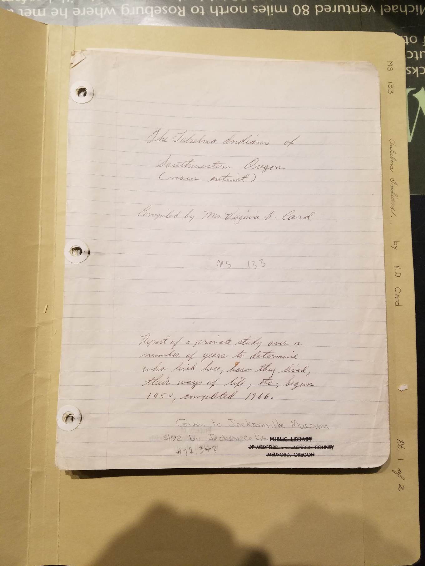
Report of a private
study over a number of years to determine who lived here, how they
lived, their ways of life, etc. Begun 1950, completed 1966.
Early in the 19th Century, James
Smithson, a British mineralogist, completed his will, leaving the bulk
of his estate to America for the purpose of gathering and dissemination
of knowledge. At odds with his own country, for reasons of birth,
Smithson expressed great interest in the United States, a country he
was never able to visit, and upon his death, $515,169.00 he had left
was passed to America. On Aug. 10, 1846, an Act of Congress created the
Smithsonian Institution, using the relatively large sum (at that time)
and since aided by many other such bequests.
Within a very short time and under
direction of J. W. Powell, the first of many exploring parties was sent
out to the southwestern states, to study and to record native races in
that area. Administration of such studies is under a Bureau of American
Ethnology, the word "ethnology" taken from the two Greek words, ethnos,
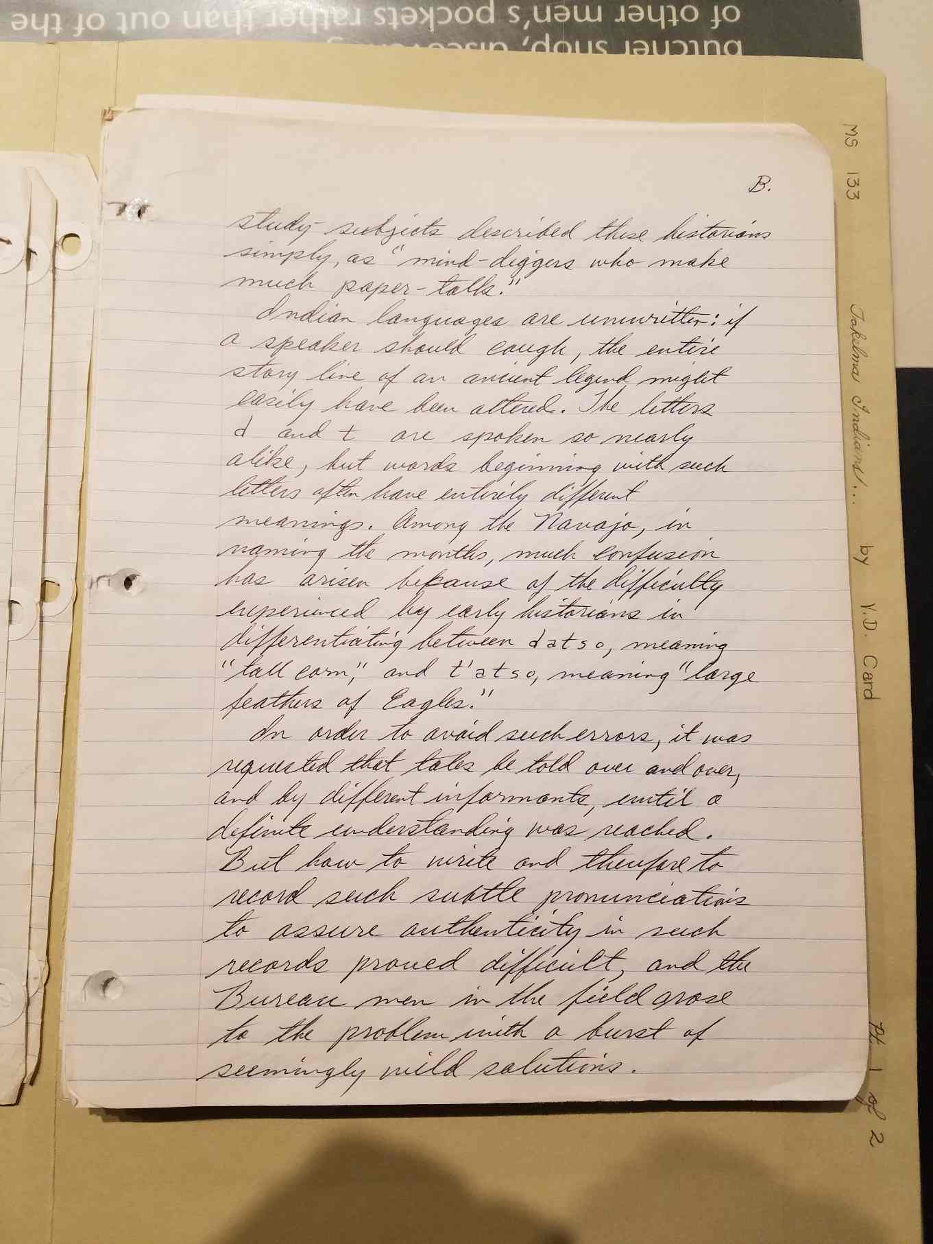
meaning "nation" and logos, meaning "word-wisdom." Many such Indian [
page B.] study
subjects described these historians simply as "mind-diggers who make
much paper-talk."
Indian languages are unwritten: if a
speaker should cough, the entire story line of an ancient legend might
easily have been altered. The letters d and t are spoken so nearly
alike, but words beginning with such letters often have entirely
different meanings. Among the Navajo, in naming the months, much
confusion has arisen because of the difficulty experienced by early
historians in differentiating between datso, meaning "tall corn," and
t'atso, meaning "large feathers of eagles."
In order to avoid such errors, it was
requested that tales be told over and over, and by different
informants, until a definite understanding was reached. Bot how to
write and therefore to record such subtle pronunciations to assure
authenticity in such records proved difficult, and the Bureau men in
the field arose to the problem with a burst of seemingly wild
solutions [
page C.].
Frank Russell, an early historian,
introduced an upside-down L which is used when that sound is softer
than the harsher English L. J. P. Harrington first wrote smaller
letters a little above the line of print to clarify certain
pronunciations. Combinations of the tk and ts are quite common among
many Indian languages, yet not all all common in English. Being
difficult to handle in the American mouth, such combinations were
helpful with the addition of many vowels. We find TKlma and Dglma
written, in English, as Takelma (the name of the Indians who inhabited
southwestern Oregon). Ideally, the T of Takelma is pronounced halfway
between T and D. Similar to this, the Navajo nt'oc, meaning
"water-source" is pronounced simply toc by Americans who seem unable to
form the word as do the Navajo, even to this time.
So it is that as time has passed and
more and different pre-historic races are studied and permanently
recorded by the B.A.E., more and different symbols are invented
.
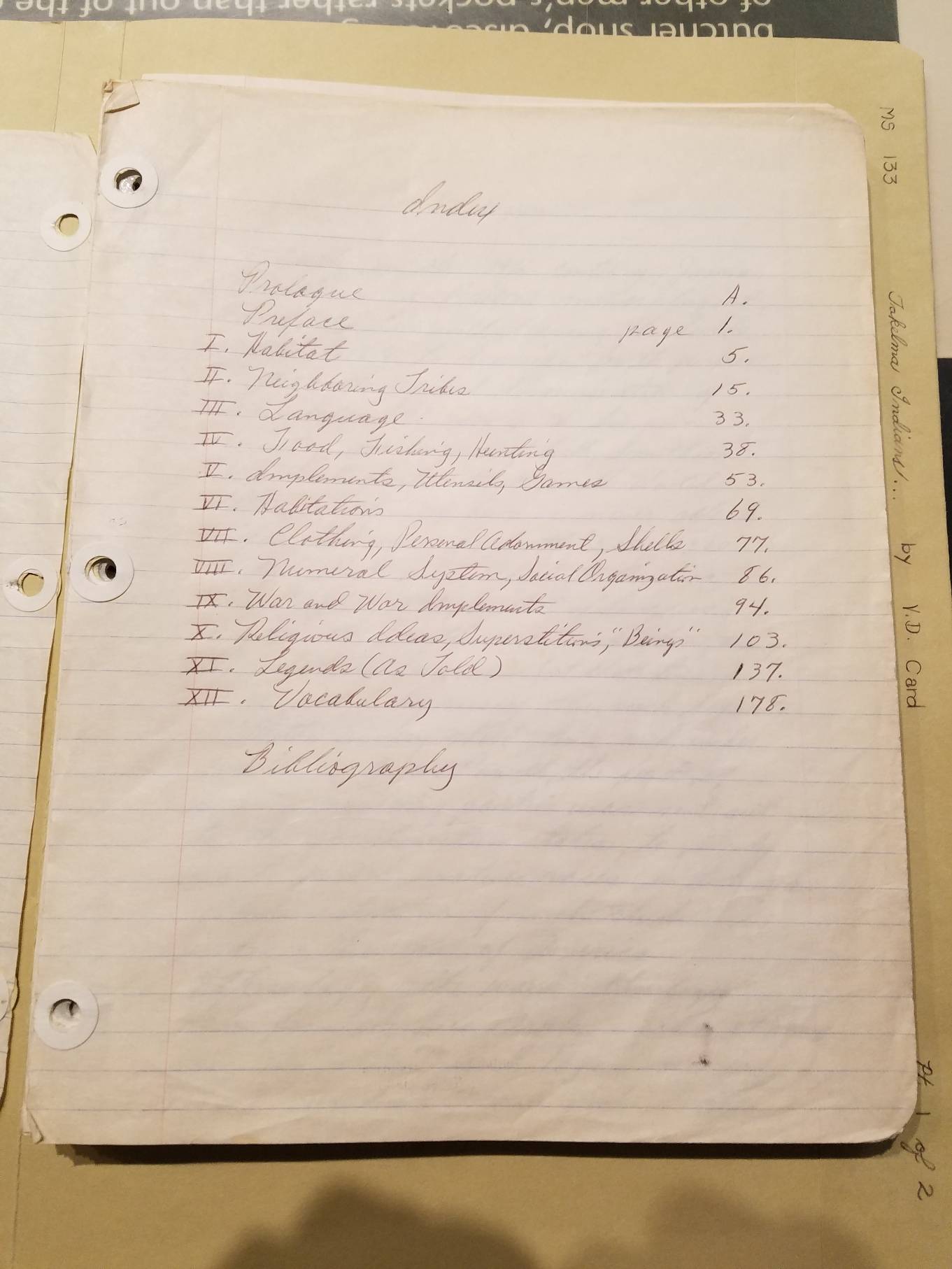
PROLOGUE 4 LINK
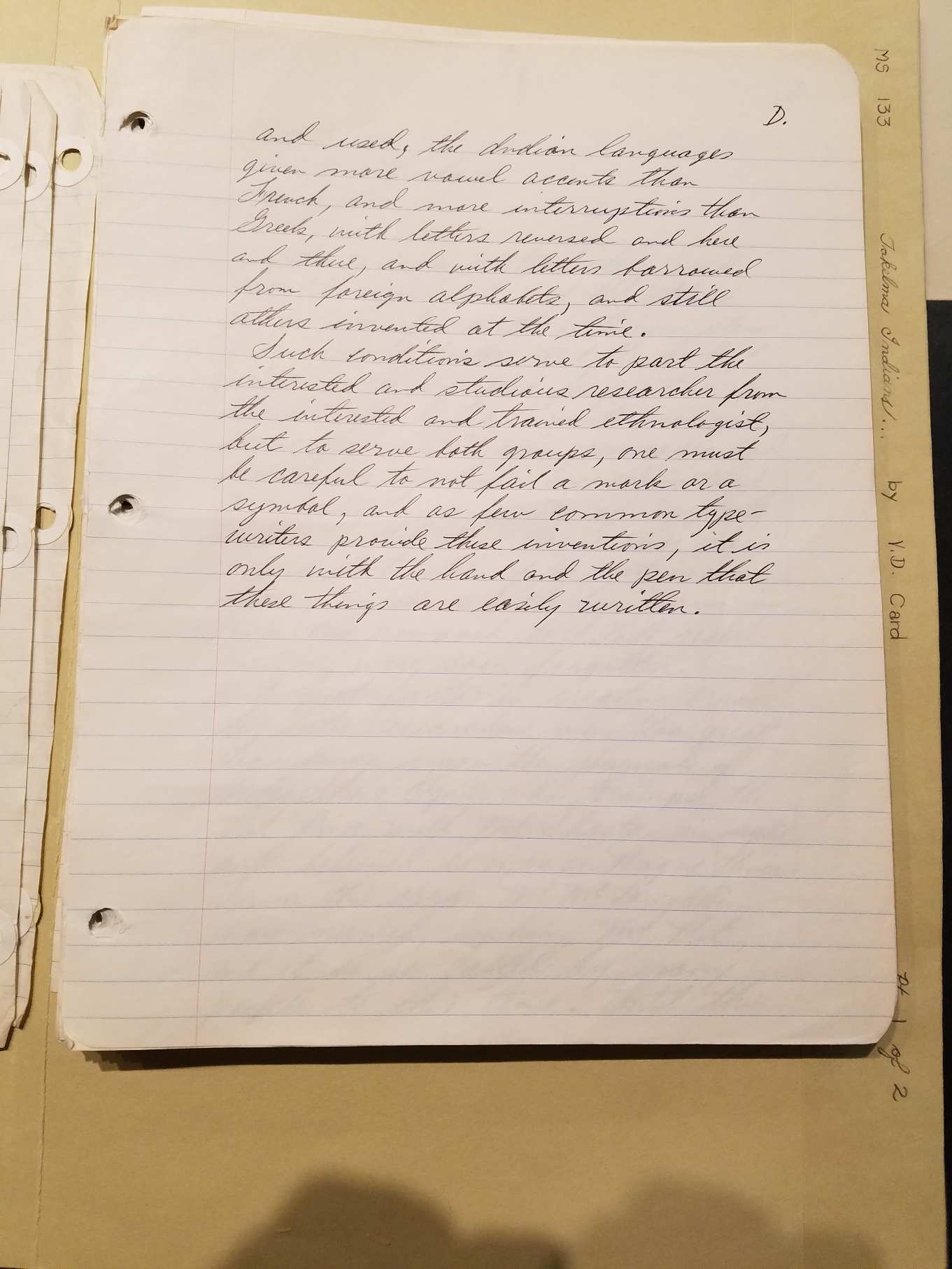
and used, the Indian languages given more vowel accents than French,
and more interruptions than Greek, with letters reversed and here and
there, and with letters borrowed from foreign alphabets, and still
others invented at the time.
Such conditions serve to part the interested and studious researcher
from the interested and trained ethnologist, but to serve more groups,
one must be careful to not misuse a mark or a symbol, and as few common
typewriters provide these inventions, it is only with the hand and the
pen that these things are easily written.
||
PAGE 1 LINK
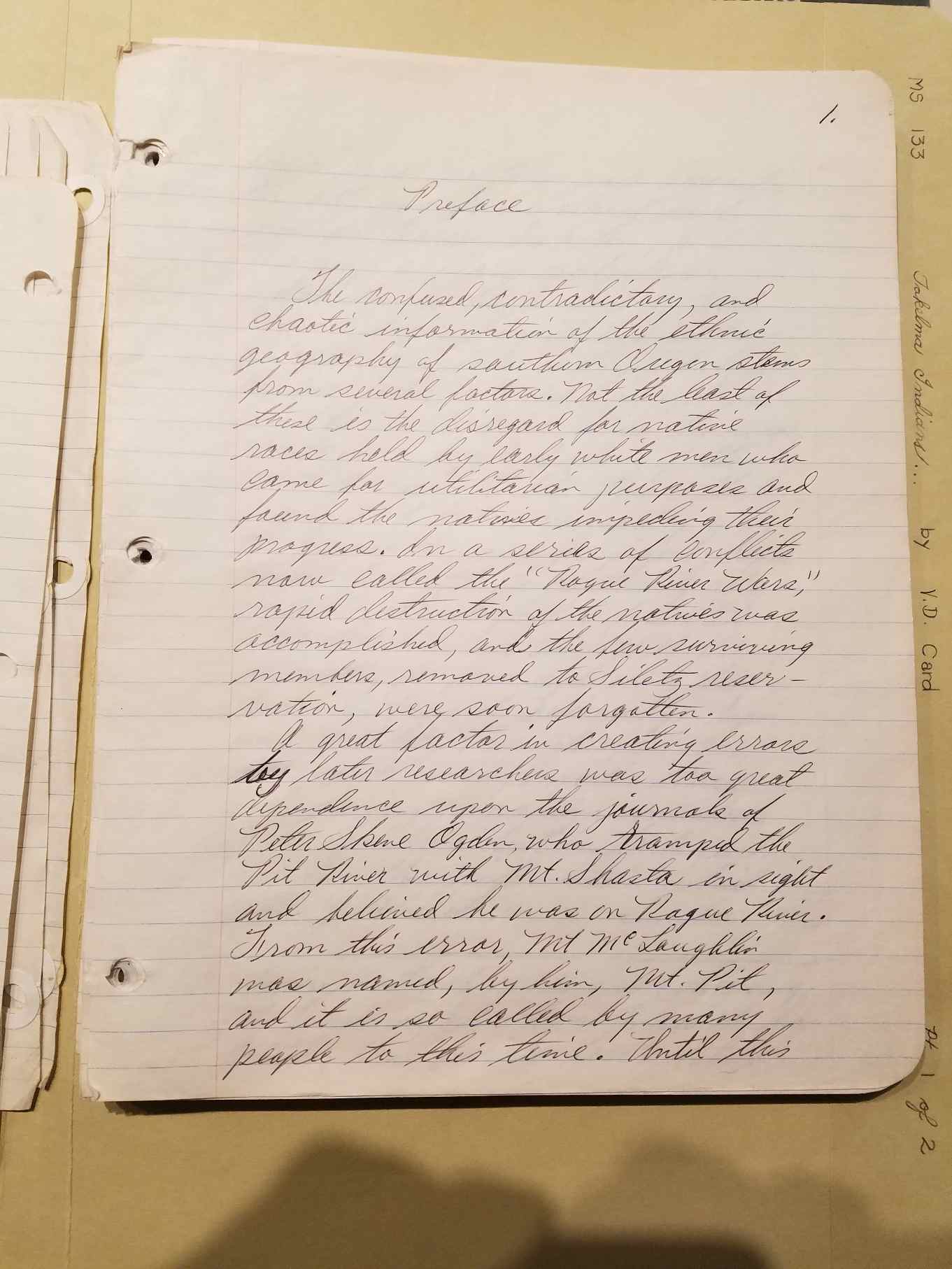
PREFACE
The confused, contradictory, and chaotic
information of the ethnic
geography of southern Oregon stems from several factors. Not the least
of these is the disregard for native races held by early white men who
came for utilitarian purposes and found the natives impeding their
progress. In a series of conflicts now called the "Rogue River Wars,"
rapid destruction of the natives was accomplished and the few surviving
members, removed to Siletz reservation, were soon forgotten. A great
factor in creating errors by later researches was too great dependence
on the journals of Peter Skene Ogden, who tramped the Pit River with
Mt. Shasta in sight and believed he was on Rogue River. From this
error, Mt. McLoughlin was named, by him, Mt. Pit, and it is so called
by many people to this time. Until this
PAGE 2 LINK
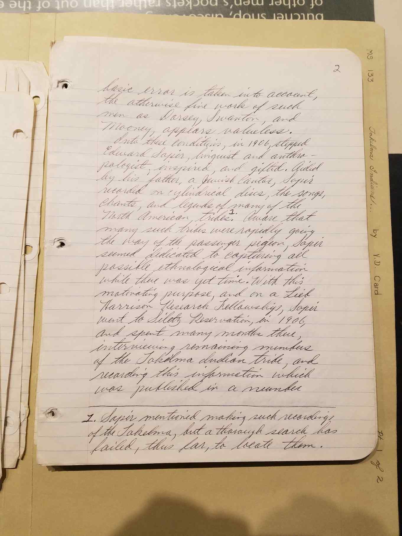
basic error is taken into account, the otherwise fine work of such men
as Dorsey, Swanton, and Mooney, appears valueless.
Into those conditions, in 1906, stepped Edward Sapir, linguist and
anthropologist, inspired and gifted. Aided by his father, a Jewish
Cantor, Sapir recorded on cylindrical discs, the songs, chants and
legends of many North American Tribes. [Footnote 1: Sapir mentioned
making such recordings of the Takelma, but a thorough search has
failed, thus far, to locate them.]
Aware that many such tribes were rapidly going the way of the passenger
pigeon, Sapir seemed dedicated to capturing all possible ethnological
information while there was yet time. With this motivating purpose, and
on a Lieb Harrison Research Fellowship, Sapir went to Siletz
Reservation in 1906, and spent many months there, interviewing
remaining members of the Takelma Indian tribe, and recording this
information which was published in a number
PAGE 3 LINK
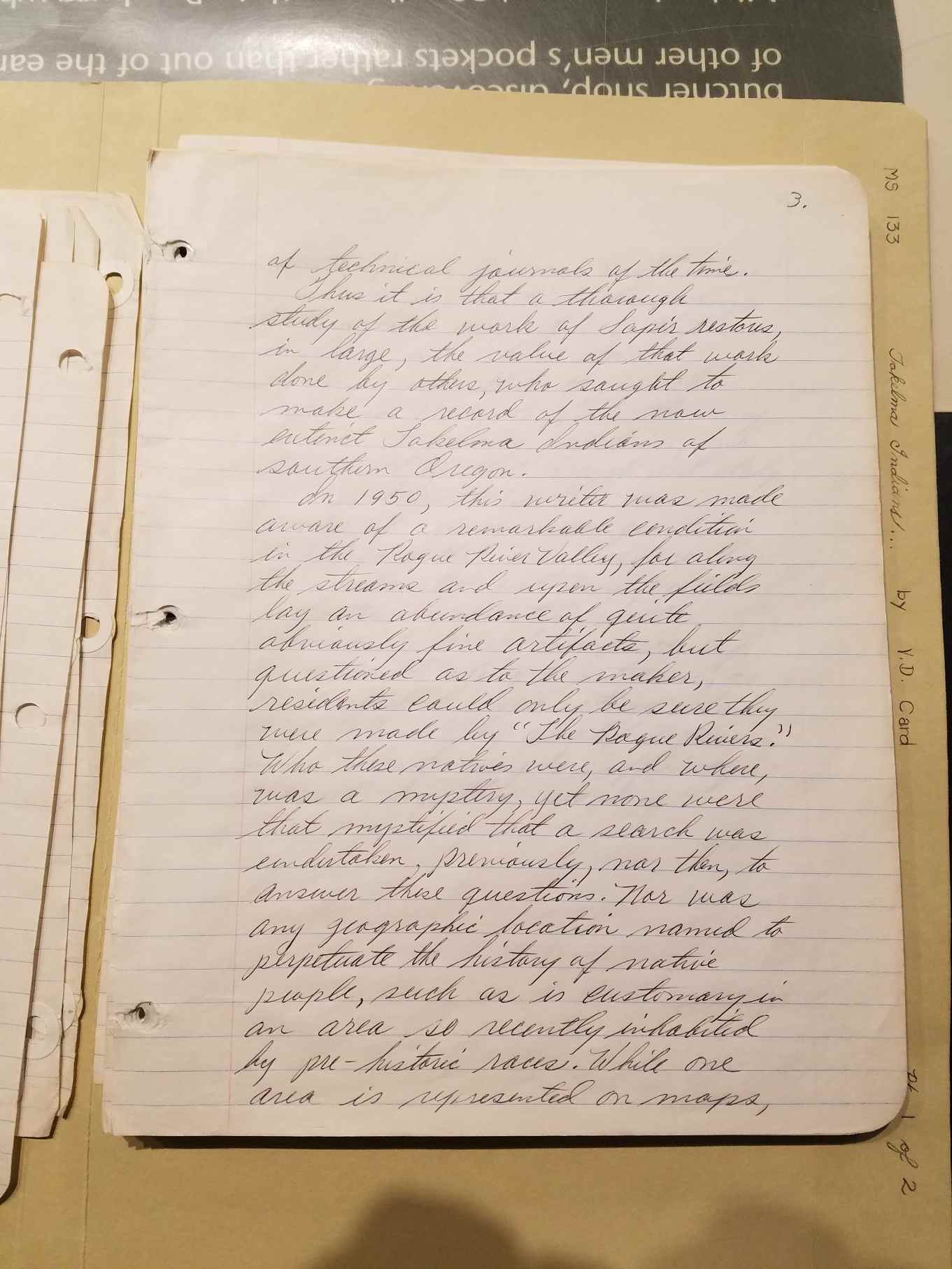
of technical journals of the time. Thus it is that a thorough study of
the work of Sapir restores, in large, the value of that work done by
others, who sought to make a record of the now extinct Takelma Indians
of southern Oregon.
In 1950, this writer was made aware of a remarkable condition in the
Rogue River Valley, for along the streams and upon the fields lay an
abundance of quite obviously fine artifacts, but questioned as to the
maker, residents could only be sure they were made by "The Rogue
Rivers." Who these natives were, and where, was a mystery, yet none
were that mystified that a search was undertaken, previously, nor then,
to answer the questions. Nor was any geographic location named to
perpetuate the history of native people, such as is customary in an
area so recently inhabited by pre-historic races. While one area is
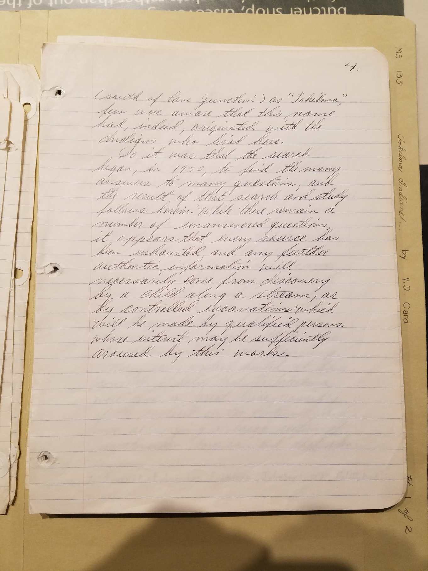
represented on maps,
PAGE 4 LINK
(south of Cave Junction) as "Takilma," few were aware that this name
had, indeed, originated with the Indians who lived here.
So it was that the search began, in 1950, to find the many answers to
many questions, and the result of that search and study follows herein.
While there remain a number of unanswered questions, it appears that
every source has been exhausted, and any further authentic information
will necessarily come from discovery by a child along a stream, or by
controlled excavations which will be made by qualified persons whose
interest may be sufficiently aroused by this work.
|| SECTION
1: HABITAT
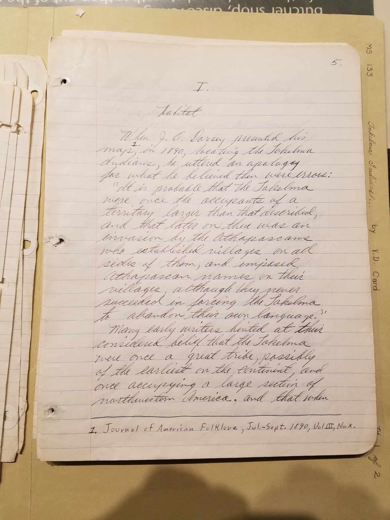
PAGE 5 LINK
When J. O. Dorsey presented his map,
[Footnote 1: Journal of American
Folklore, Jul-Sept. 1890, Vol III, No. X.] in 1890, locating the
Takelma Indians, he uttered an apology for what he believed then were
errors: "It is probable that the Takelma were once the occupants of a
territory larger than that described, and that later on there was an
invasion by the Athapascans who established villages on all sides of
them, and imposed Athapascan names on their villages, although they
never succeeded in forcing the Takelma to abandon their own language."
Many early writers hinted at their considered belief that the Takelma
were once a great tribe, possibly of the earliest on the continent, and
once occupying a large section of North America, and that when
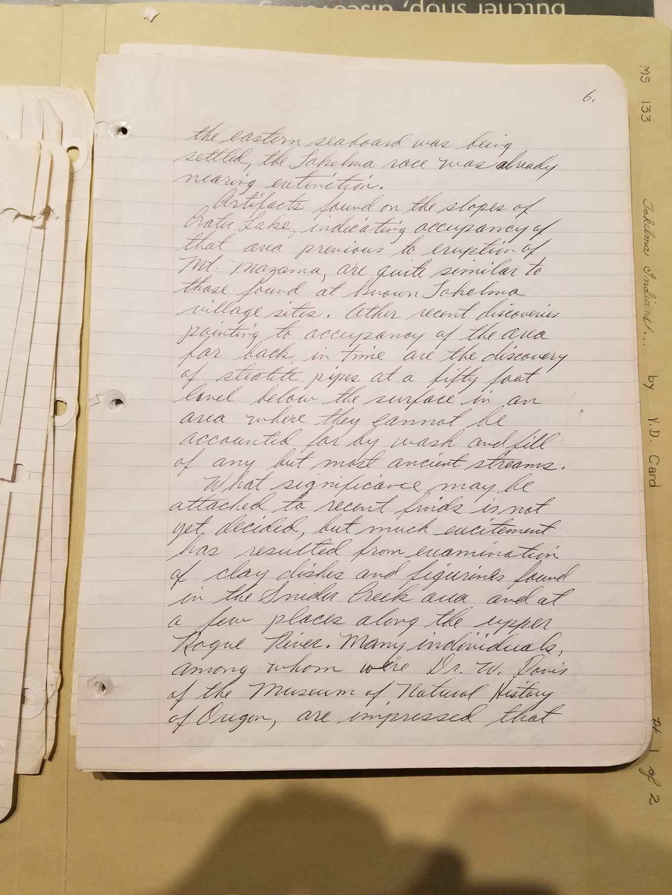
PAGE 6 LINK
the eastern seaboard was settled, the Takelma race was already nearing
extinction.
Artifacts found on the slopes of Crater Lake, indicating occupancy of
that area previous to eruption of Mt. Mazama, are quite similar to
those found at known Takelma village sites. Other recent discoveries
pointing to occupancy of the area far back in time are the discovery of
steatite pipes at fifty foot level below the surface in an
area
where they cannot be accounted for by wash and fill of any but most
ancient streams.
What significance may be attached to recent finds is not yet decided,
but not much excitement has resulted from examination of clay dishes
and figurines found in the Snider Creek area and at a few places along
the upper Rogue River. Many individuals among whom were Dr. W. Davis
[sic] of
the Museum of Natural History of Oregon, are impressed that
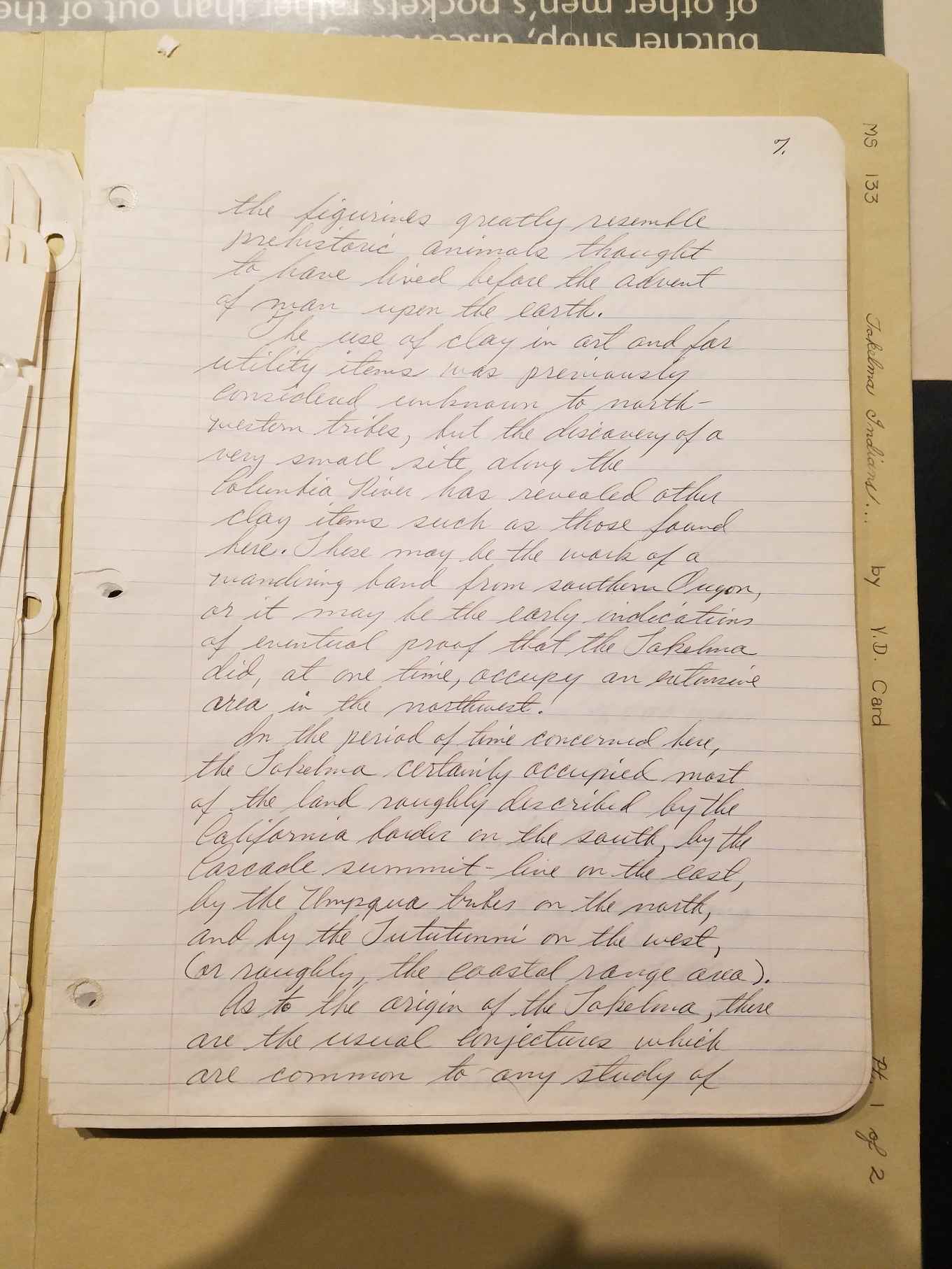
PAGE 7 LINK
the figurines greatly resemble prehistoric animals thought to have
lived before the advent of man upon the earth.
The use of clay in art and for utility items was previously considered
unknown to northwestern tribes, but the discovery of a very small site
along the Columbia River has revealed other clay items such as those
found here. These may be the work of a wandering band from southern
Oregon, or it may be the early indications of eventual proof that the
Takelma did, at one time, occupy an extensive area in the northwest.
In the period of time concerned here, the Takelma certain occupied most
of the land roughly described by the California border on the south, by
the Cascade summit-line on the east, by the Umpqua tribes on the north,
and by the Tututunni on the west (or roughly, the coastal range area).
As to the origin of the Takelma there are the usual conjectures which
are common to any study of
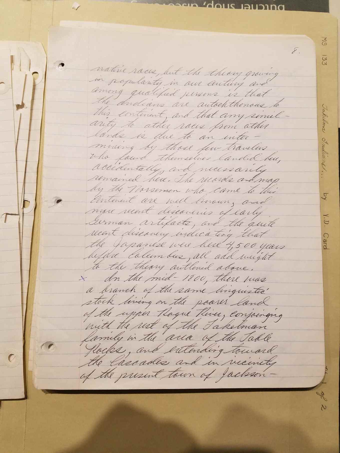
PAGE 8 LINK
native races, but the theory growing in popularity in our century and
among qualified person is that the Indian are autochthonous to
this continent, and that any similarity to other races from other lands
is due to inter-mixing by those few travelers who found themselves
landed here, accidentally, and necessarily remained here. The records
and map by the Norsemen who came to this continent are well known, and
more recent discoveries of early German artifacts, and the quite recent
discovery indicating that the Japanese were here 4,500 years before
Columbus, all add weight to the theory outlined above.
In the mid-1800, there was a branch of the same linguistic stock living
on the poorer land of the upper Rogue River, conjoining with the rest
of the Takelman family in the area of the Table Rocks, and extending
toward the Cascades and in vicinity of the present town of
Jacksonville.
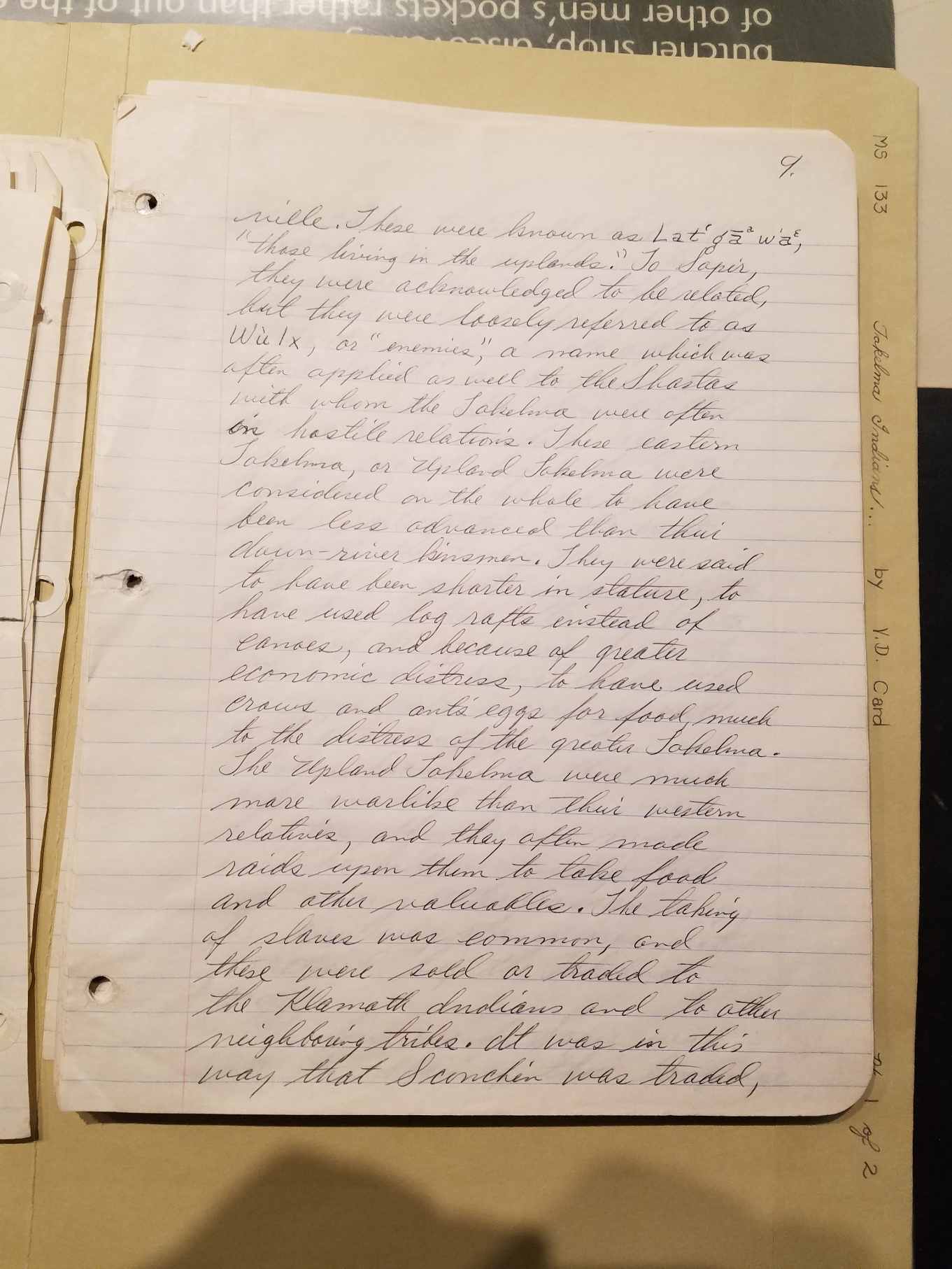
PAGE 9 LINK
These were known as Lat'ga w'a [sic],
"those living in the uplands." To
Sapir, they were acknowledged to be related, but they were loosely
referred to as Wulx [sic],
or "enemies," a name which was often applied
as well to the Shasta with whom the Takelma were often in hostile
relations. These eastern Takelma, or Upland Takelma, were considered on
the whole to have been less advanced than their down=river kinsmen.
they were said to have been shorter in stature, to have used log rafts
instead of canoes, and because of greater economic distress, to have
used crows and ants' eggs for food, much to the distress of the
greater Takelma. The Upland Takelma were much more warlike than their
western relatives, and they often made raids upon them to take food and
other valuables. The taking of slaves was common, and these were sold
or traded to the Klamath Indians and to other neighboring tribes. It
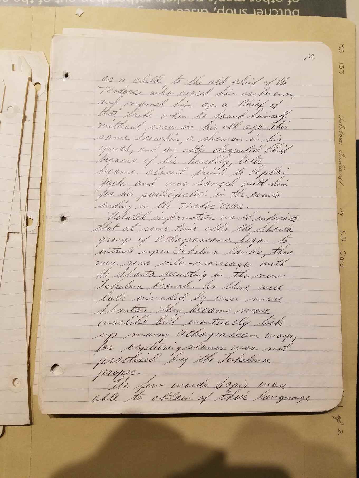
was in this way that Sconchin was traded,
PAGE 10 LINK
as a child, to the old chief of the Modocs who reared him as his own,
and named him as a Chief of that tribe when he found himself without
sons in his old age. This same Sconchin, a shaman in his youth, and an
often disputed Chief because of his heredity, later became closest
friend to Captain Jack and was hanged with him for his participation in
the events ending in the Modoc War.
Relation information would indicate that at some time after the Shasta
group of Athapascans began to intrude upon Takelma lands, there were
some inter-marriages with the Shasta resulting in the new Takelma
branch. As these were later invaded by even more Shastas, they became
more warlike but eventually took up many Athapascan ways, for capturing
slaves was not practiced by the Takelma proper.
The few words Sapir was able to obtain of their language
PAGE 11 LINK
show it to have been very nearly the same as that of the Takelma
proper, but with distinct phonetic and lexicographic dialectic
difference, which have since proven related to Shastan words: [view
card001.jpg for
the orthograpical signs used in the following words,
and an explanation of them]
Upper dialect: English: Takelma t!eweks: flea: t!ewex
yegwetci: they bite me: yegwexi
tgantgan: fly: bus
wiyip't'enea: as I was traveling about: wit'eda
K'wna"s t': his relatives: K'winaxda
PAGE 12 LINK
Leslie Spier, in an article for the Oregon Historical Society Quarterly
["Tribal Distribution in Southwestern Oregon," Vol. 28.], tells of his
own studies of the Takelma Indians. He reports the Klamath Indians told
him that they called the Takelma "Walumshni [sic]
in historic times. In
his interviews, they placed the Shasta on Klamath River as far upstream
as Shovel Creek near the California-Oregon border, and they held only
Jenny Creek north of that border. The Klamaths assured him that the
Shasta were not located north of the Siskiyous in the Bear Creek
Valley, but that this land was occupied by the Walumshni for its entire
length.
Mr. Spier is among those who reported the presence of Molalas along the
upper Rogue, and he quotes Joel Palmer, Indian Agent, who wrote (in
1853):
"While on late expeditions I came to the knowledge of the existence of
a tribe of Indians
PAGE 13 LINK
inhabiting the country on the upper waters of the northern and southern
forks of the Umpquas, and along the headwaters of the Rogue, called the
Mo-lal-la-las."
Jamie Teit, in an article for Anthropology Magazine ["The Middle
Columbia Salish;" Univ. of Washington, pub. in Anthropology 2, No. 4.],
further explains the presence of the Molalas in southern Oregon by
relating attacks by the Snake Indians, in about 1750, which resulted in
the displacement of three tribes: the Shahaptians [sic]
of upper
Deschutes removed to the Washington side of the Columbia; the Cayuse
proceeded eastward, and the Molalas were driven from the lower
Deschutes and westward, into the mountains, and beyond Willamette
Valley.
These Molalas drifted southward and made late settlements along the
high ridge creeks and down to the canyon as far as Prospect and Trail
Creek, with a few
PAGE 14 LINK
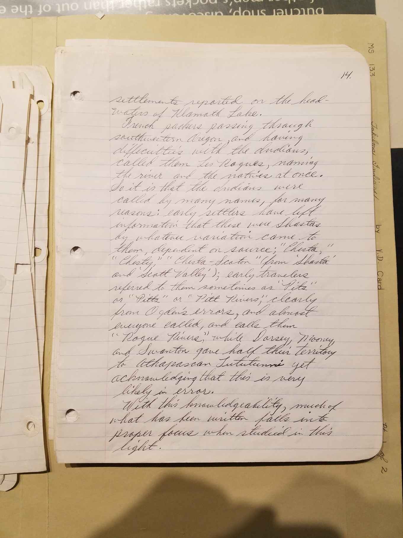
settlements reported on the headwaters of Klamath Lake.
French packers passing through southwestern Oregon, and having
difficulties with the Indians, called them Les Rogue, naming the river
and the natives at once. So it is that the Indians were called by many
names, for many reasons: early settlers have left information that
these were Shastas by whatever variation came to them, depending on
source; "Chista," "Chesty," "Chista-Scoton" (from "Shasta" and "Scott
Valley"), early travelers referred to them sometimes as "Pits" or
"Pitts" or "Pitt Rivers," clearly from Ogden's errors, and almost
everyone called, and calls them "Rogue Rivers" while Dorsey, Mooney and
Swanton gave half their territory to Athapascan Tututunni yet
acknowledging that this is very likely in error.
With this knowledgeability, much of what has been written falls into
proper focus when studied in this light.
|| SECTION
II: NEIGHBORING TRIBES
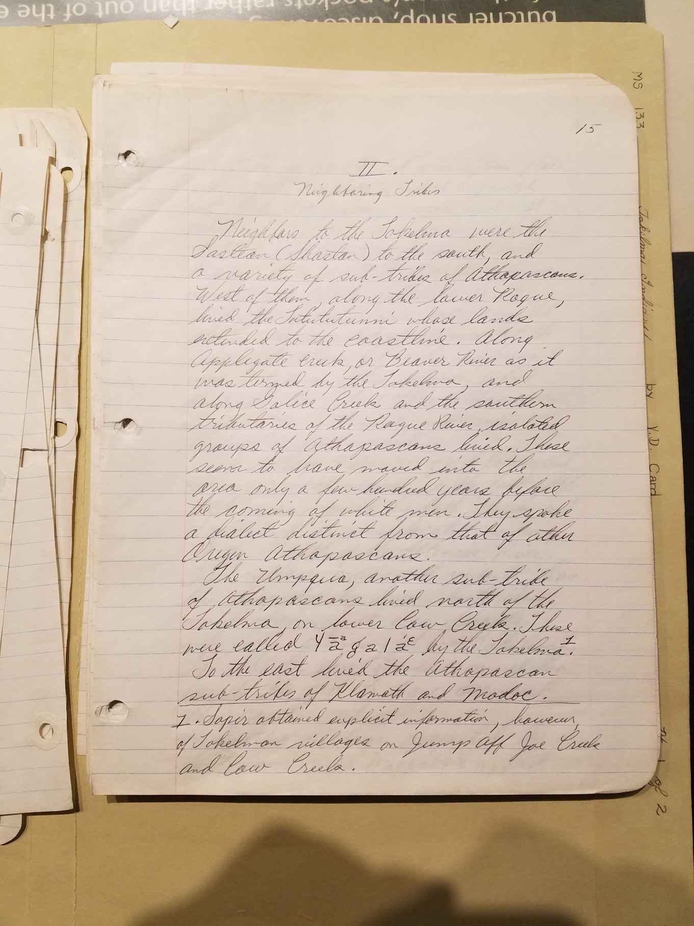
PAGE 15 LINK
Neighbors to the Takelma were the
Shastean (Shastan) to the south, and
a variety of sub-tribes of Athapascans. West of them, along the lower
Rogue, lived the Tututunni, whose lands extended to the coastline.
Along Applegate Creek, or Beaver River as it was termed by the Takelma,
and along Galice Creek and the southern tributaries of the Rogue River,
isolated groups of Athapascans lived. These seem to have moved into the
area only a few hundred years before the coming of white men. They
spoke a dialect distinct from that of other Oregon Athapascans. The
Umpqua, another sub-tribe of Athapascans, lived north of the Takelma,
on lower Cow Creek. These were called Yagala [sic]
by the Takelma [Sapir
obtained explicit information, however of Takelman villages on Jump Off
Joe Creek and Cow Creek.]
PAGE 16 LINK
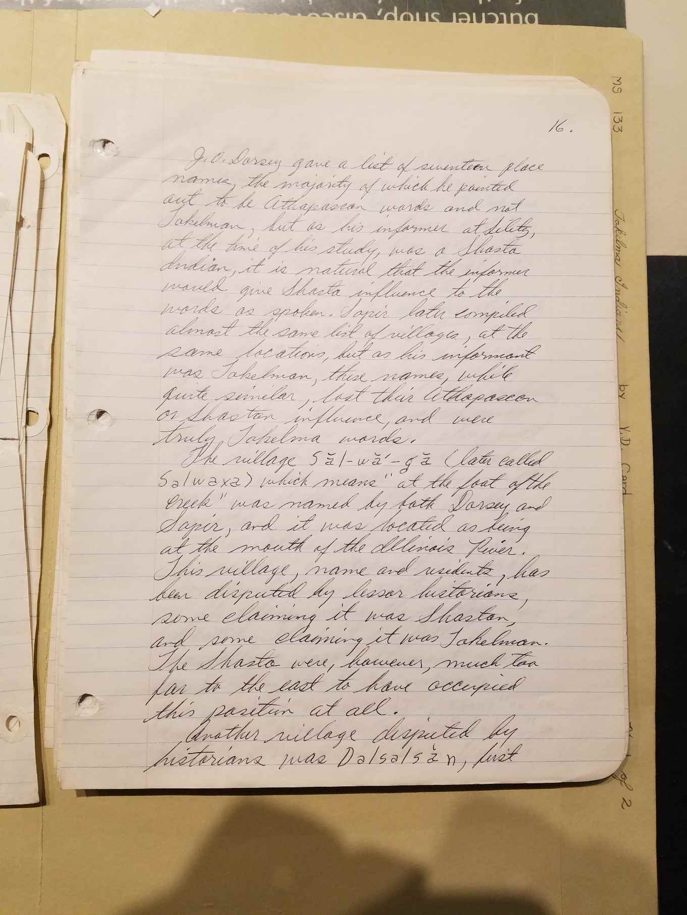
J. O. Dorsey gave a list of seventeen
place names, the majority of
which he pointed out to be Athapascan words and not Takelman, but as
his informer at Siletz, at the time of his study, was a Shasta Indian,
it is natural that the informer would give Shasta influence to the
words as spoken. Sapir later compiled almost the same list of villages,
at the same locations, but his informant was Takelman, these names,
while quite similar, lost their Athapascan or Shastan influence, and
were truly Takelma words. The village Sal-wa-ga (later
called
Salwaxa), which means "at the foot of the creek," was named by both
Dorsey and Sapir, and it was located as being at the mouth of the
Illinois River. This village, name and residents, has been disputed by
lesser historians, some claiming it was Shastan, and some claiming it
was Takelman. The Shasta were, however, much too far to the east to
have occupied this position at all.
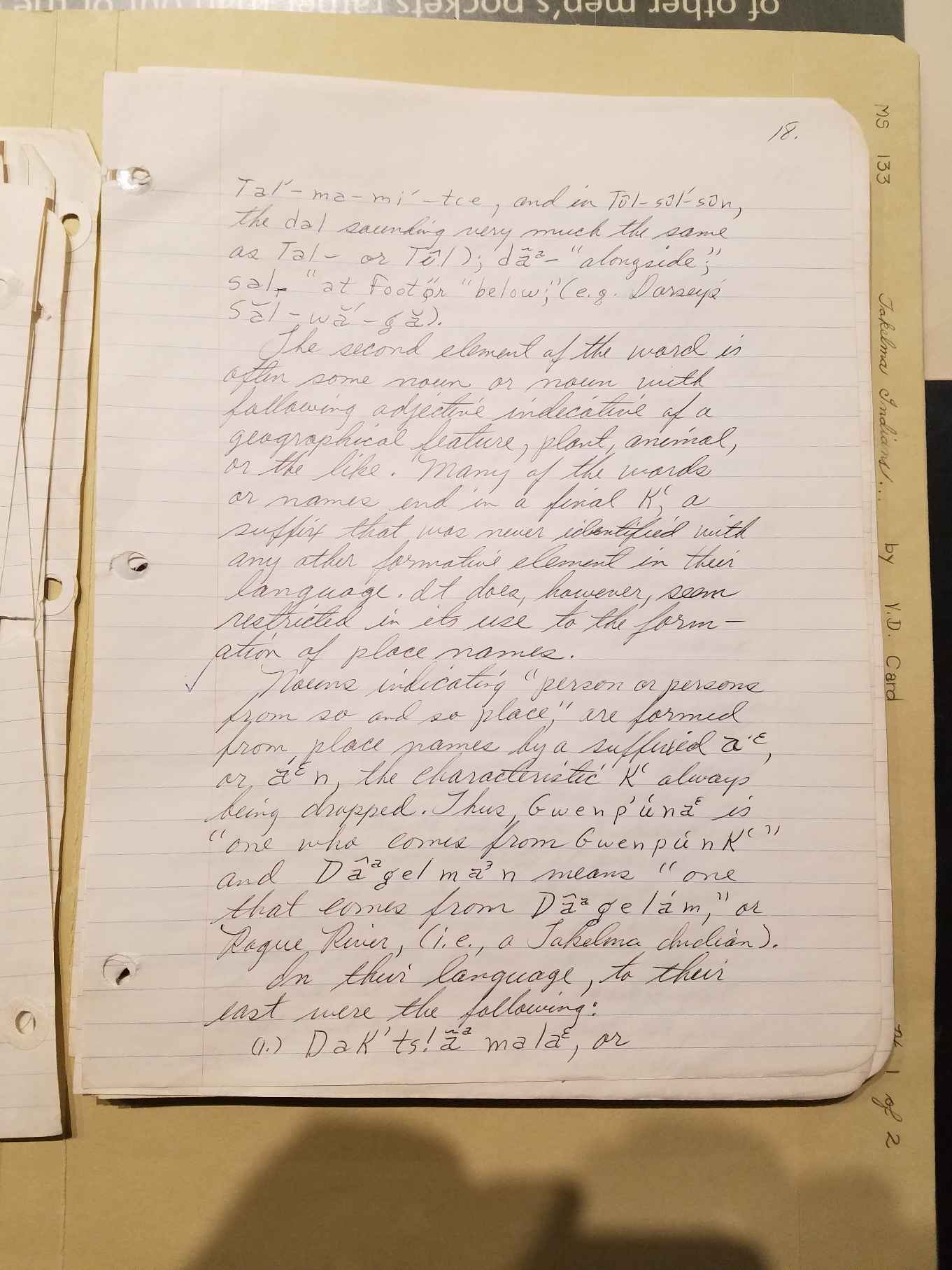
Another village disputed by historians was Dalsasan [sic],
first
PAGE 17
PAGE 18 LINK
Tal'-ma-mi-tie, and in Tul-sul-sun, the dal sounding very much the same
as Tal-or Tul); da- "alongside;" sal- "at foot" or "below" (e.g.
Dorsey's Sal-wa-ga).
The second element of the word is often
some noun or noun with
following adjective indicative of a geographical feature, plan, animal,
or the like. Many of the words or names end in a final K, a suffix that
was never identified with any other formative element in their
language. It does, however, seem restricted in its use to the formation
of place names.
Nouns indicating "person or persons from so and so place," are formed
from place names by a suffixed a'e, or a'e n, the characteristic K'
always being dropped. Thus, Bwenp'una is "one who comes from Genpunk'"
and Daagelman means "one that comes from Dagela'm," or Rogue River
(i.e., a Takelma Indian).
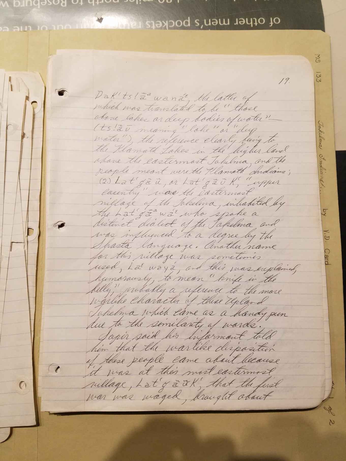
In their language to their east were the following: (1) Dak'ts!a mala,
or
PAGE 19 LINK
Dak'ts!awana, the latter of which was translated to be "those above
lakes or deep bodies of water" (ts!av meaning "lake" or "deep
water"), the reference clearly being to the Klamath Lakes in the higher
land above the easternmost Takelma, and the people meant were the
Klamath Indians; (2) Lat'ga u, or Lat Gau K', "upper country" was the
easternmost village of the Takelma, inhabited by the Latgawa who spoke
a distinct dialect of the Takelma, and was influenced to a degree by
the Shasta language. Another name for this village was sometimes used,
La waya, and this was explained, humorously, to mean "knife in the
belly," probably a reference to the more warlike character of the
Upland Takelma which came as a handy pun due to the similarity of
words.
Sapir said his informant told him that the warlike disposition of those
people came about because it was at this most easternmost village,
Lat'g a u K', that the first war was waged, brought about
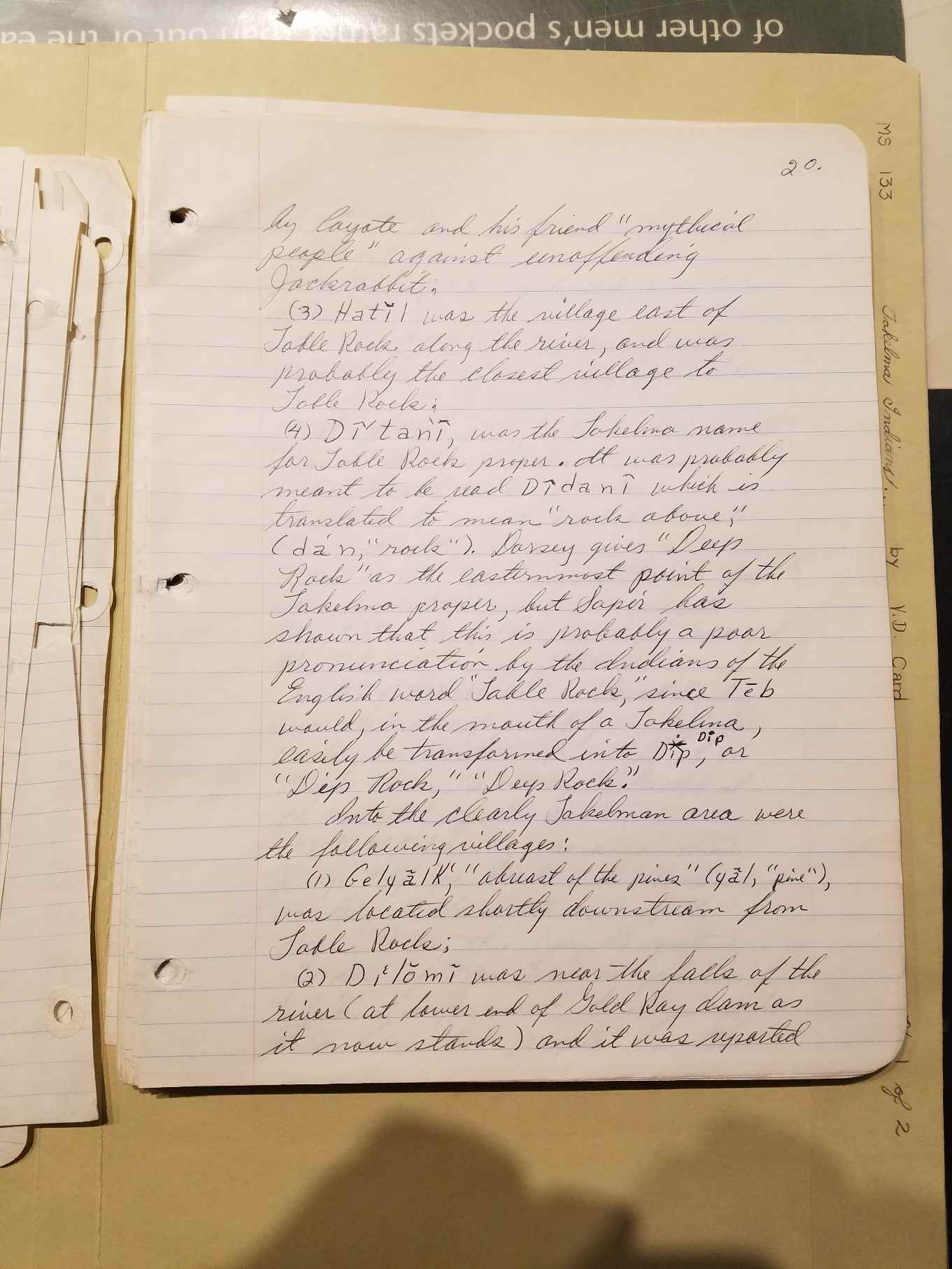
PAGE 20 LINK
by Coyote and his friend "mythical people" against unoffending
Jackrabbit.
(3) Hatil was the village east of Table Rock along the river and was
probably the closest village to Table Rock.
(4) Di'tani, was the Takelma name for Table Rock proper. It was
probably meant to be read Didani which is translated to mean "rock
above," (dan, "rock"). Dorsey gives "Deep Rock" as the easternmost
point of the Takelma proper, but Sapir has shown that this is probably
a poor pronunciation by the Indians of the English word "Table Rock,"
since Teb would, in the mouth of a Takelma, easily be transformed into
Dip, or "Dip Rock," "Deep Rock."
Into the clearly Takelman area were the following villages:
(1) Gelyalk', "abreast of the pines (yal, "pine), was located shortly
downstream from Table Rock;
(2) Dilomi was near the falls of the river (at lower end of Gold Ray
dam as it now stands) and it was reported
PAGE 22 LINK
(Note: There is no page 21 in the manuscript)
to have been an unusually large village;
(3) Genp'unK', unlocated, was below Dilomi;
(4) Haylba'lsda, "in its long or tall pines," (ya l, "pine" Bals,
"long") was below 3;
(5) Dak't'game K', "above which are elk," (t'gam, "elk) was below 4;
(6) Didala'm, "over the rocks," was on the site of the present town of
Grants pass, along the river;
(7) Sbink', "beaver place," (sbin, "beaver"), which was at the mouth of
Applegate River, Sbin being their name for beaver and the Takelma name
of that river;
(8) Dip!olts!ilda, "on its red banks" was the name of present Jump Off
Joe Creek, an eastern tributary to the Rogue River, the village
situated at the mouth of the creek;
(9) Dak'ts!asin, was also near Jump Off Joe Creek and described as
being on the north side of the Rogue River this being the native
village of Mrs. Frances Johnson, Takelma informant to Sapir, who told
him that people from this
PAGE 23 LINK
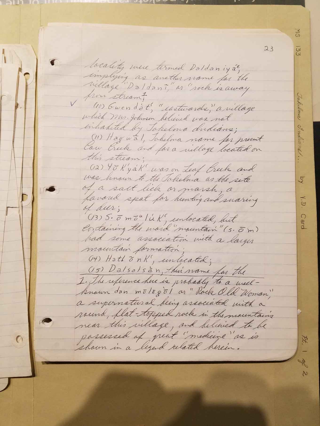
locality were termed Daldania, implying as another name for the village
"Daldani," or "rock is away from stream; [The reference here is
probably to a well-known dan mologol or "Rock Old Woman," a
supernatural being associated with a round, flat-topped rock in the
mountains near this village and believed to be possessed of great
"medicine," as is shown in a legend related herein.]
(10) Gwendat', "eastwards," a village which Mrs. Johnson believed was
not inhabited by Takelma Indians;
(11) Hagwal, Takelma name for present Cow Creek and for a village
located on this stream;
(12) YuKya'K' was on Leaf Creek and was known to the Takelma as the
site
of a salt lick or march, a favored spot for hunting and snaring of
deer;
(13) SomoluK', unlocated, but containing the word "mountain" (som) had
some association with a larger mountain formation;
(14) Hat!onK', unlocated;
(15) Dalsalsan, their name for the
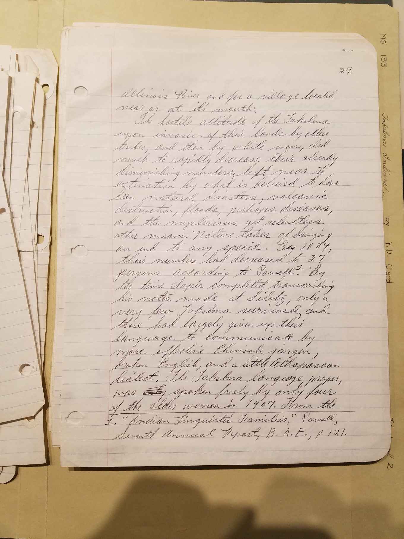
PAGE 24 LINK
Illinois River and for a village located near or at its mouth
The hostile attitude of the Takelma upon invasion of their lands by
other tribes, and then by white men, did much to rapidly decrease their
already diminishing numbers, left near to extinction by what is
believed to have been natural disasters, volcanic destruction, floods,
perhaps diseases, and the mysterious yet relentless other means Nature
takes of bringing an end to any specie. By 1884, their numbers had
decreased to 27 persons according to Powell. ["Indian Linguistic
Families," Powell, Seventh Annual Report, B.A.E., p 121.]
By the time Sapir completed transcribing his notes made at Siletz, only
a very few Takelma survived, and those had largely given up their
language to communicate by more effective Chinook jargon, broken
English, and a little Athapascan dialect. The Takelma language proper,
was spoken freely by only four of the older women in 1907. From the
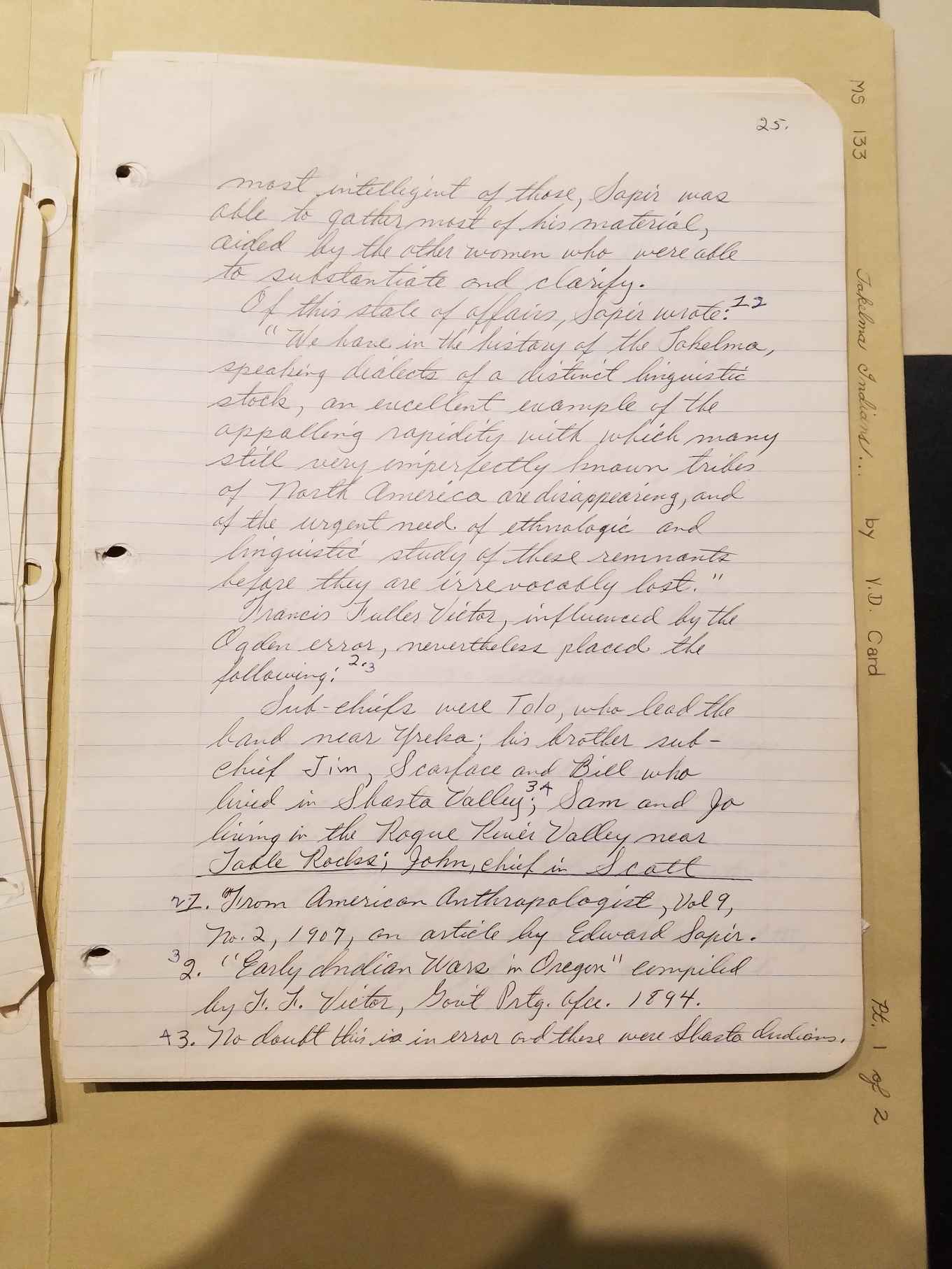
PAGE 25 LINK
most intelligent of those, Sapir was able to gather most of his
material, aided by the other women who were able to substantiate and
clarify.
Of this state of affairs, Sapir wrote: "We have in the history of the
Takelma, speaking dialects of a distinct linguistic stock, an excellent
example of the appalling rapidity with which many still very
imperfectly known tribes of North America are disappearing, and
linguistic study of these remnants before they are irrevocably lost."
[From American Anthropologist, Vol 9, no. 2, 1907, an article by Edward
Sapir.]
Francis Fuller Victor, influenced by the Ogden error, nevertheless
placed the following["Early Indian Wars in Oregon" compiled by F. F.
Victor, Government Printing Office 1894]:Sub-chiefs were Tolo, who lead
the band near Yreka; his brother sub-chief Jim, Scarface and Bill who
lived in Shasta Valley; [Card note: no doubt this is in error and these
were Shasta Indians] Sam and Jo living in the Rogue River Valley near
Table Rocks; John, chief in Scott
PAGE 26 LINK
Valley [Obviously in error and these were "Scotons."]; John's father,
once chief over all; and Tipso, or "hairy bearded one" with Sullix or
"bad tempered" who lived at the foot of the Siskiyous;
Chief Sam's camp was at Big Bor near the confluence of the Rogue and
Bear (Stuart) rivers [probably at the village Hatil], and a subchief
Taylor lived in the Grave Creek country.
On his map [from Journal of American Folklore, vol 3, no. 10,
July-Sept. 1890, an article by J. O. Dorsey]Dorsey has placed the names
of 269 villages, and labeled these as Yaquinan, 56 villages
California Athapascan, 13 villages
Oregon Athapascan, 106 villages
Takelman, 17 villages
Alsea, 20 villages
Siuslaw, 34 villages
Lower Umpqua (Ku-itc), 21 villages
As has been stated, an indefinite number of the "Oregon Athapascan"
PAGE 27 LINK
villages claimed here were in truth, Takelman villages, and of these he
has located the following:
(1) Hudedut, on the south side of Rogue River at the mouth of Applegate
River (across from another village);
(2) A village at the mouth of Evans Creek which name was not obtained;
(3) Talotunne, directly across from where Evans Creek empties into
Rogue River, and across it from the above village 2;
(4) K'ac-ta-ta, just above Galice Creek;
(5) CKac'-tun, at confluence of Leaf Creek;
(6) Tco-wa-tce, above "Deep Rock" [The village along Little Butte Creek
where it empties into the Rogue River, scene of the Lupton attack.]
In his work ["The Indian Tribes of North America," pub. by Smithsonian
Institution, B.A.E., Wash. 1953.], J. R. Swanton says, "… in
California, and in western Oregon, and Washington as well, tribe and
town might be considered convertible terms," and he continues to use a
method wherein he was satisfied with a
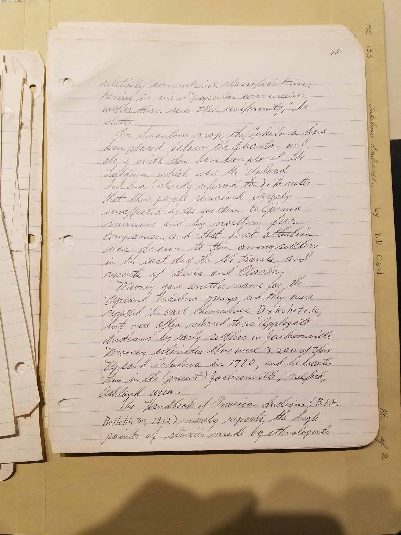
PAGE 28 LINK
relatively conventional classifications, having in view "popular
convenience rather than scientific uniformity," he states.
On Swanton's map, the Takelma have been placed below the Shasta, and
along with them have been placed the Latgwa which were the Upland
Takelma (already referred to). He notes that these people remained
largely unaffected by the southern California missions and by norther
fur companies, and that first attention was drawn to them among
settlers in the east due to the travels and reports of Lewis and Clark.
Mooney gave another name for the Upland Takelma group, and they were
reported to call themselves Dakubetede, but were often referred to as
"Applegate Indians" by early settlers in Jacksonville. Mooney estimates
there were 3,200 of these Upland Takelma in 1780, and he locates them
in the (present) Jacksonville, Medford, Ashland area. The Handbook of
American Indians (B.A.E. Bulletin 30, 1912) merely reports the high
points of studies made by ethnologists
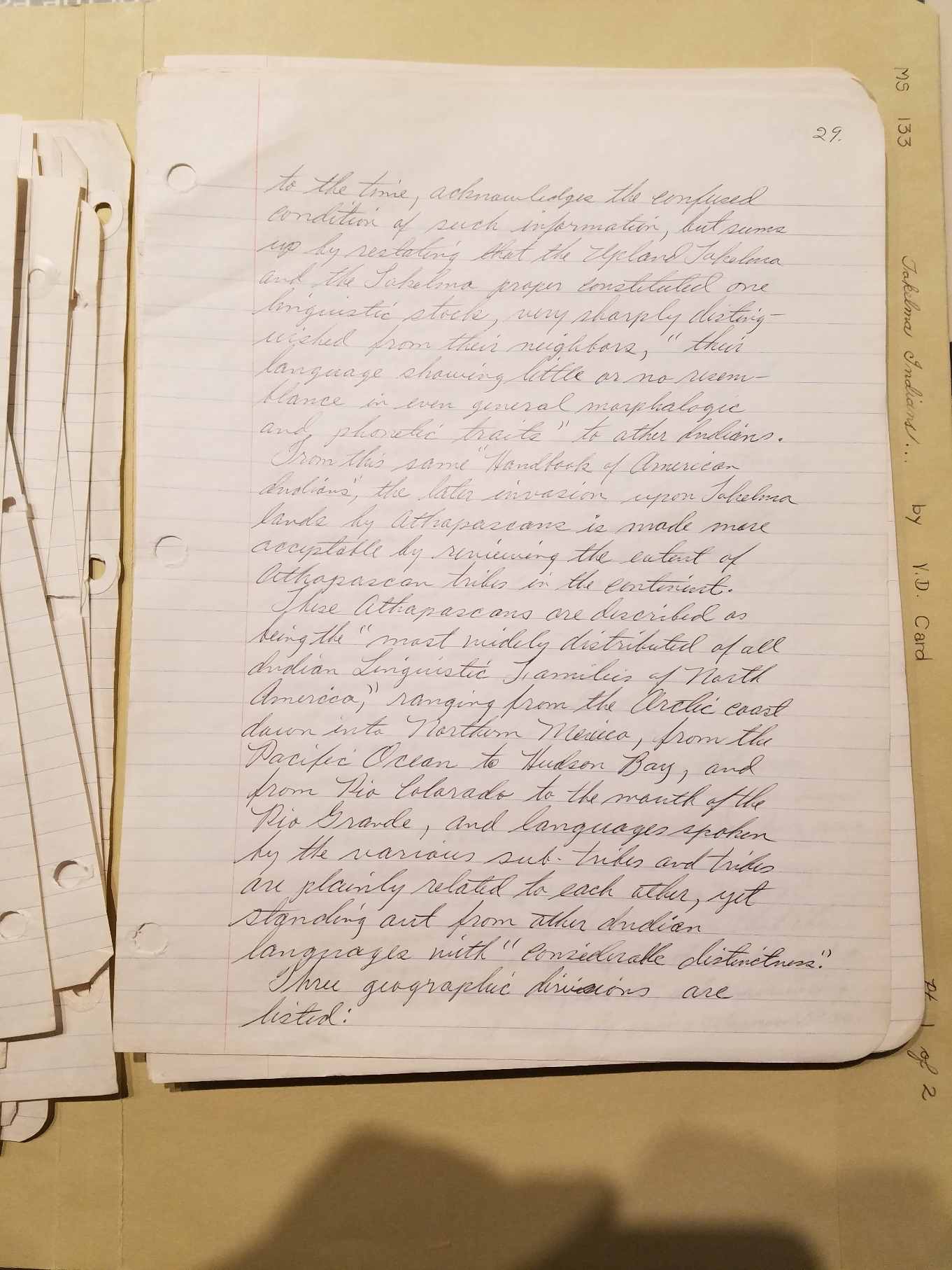
PAGE 29 LINK
to the time, acknowledges the confused condition of such information,
but sums up by restating that the Upland Takelma and the Takelma proper
constituted one linguistic stock, very sharply distinguished from their
neighbors, "their language showing little or no resemblance in even
general morphologic and phonetic traits" to other Indians. From this
same "Handbook of American Indians," the later invasion upon Takelma
lands by Athapascans is made more acceptable by reviewing the extent of
Athapascan tribes in the continent. These Athapascans are described as
being the "most widely distributed of all Indian linguistic families of
North America," ranging from the Arctic coast down into Northern
Mexico, from the Pacific Ocean to Hudson Bay, and from the Rio Colorado
to the mouth of the Rio Grande, and languages spoken by the various
sub-tribes and tribes are plainly related to each other, yet standing
out from other Indian languages with 'considerable distinctness." Three
geographic divisions are listed:
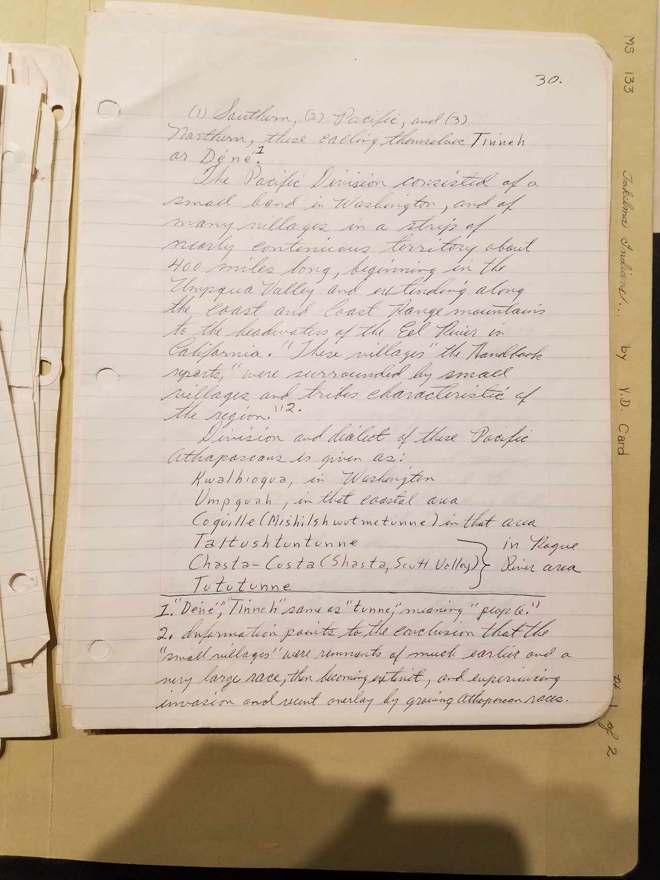
PAGE 30 LINK
(1) Southern; (2) Pacific; and (3) North, these calling themselves
Tinneh or Dene. ["Dene," "Tinneh" same as "tunne," meaning "people."]
The Pacific Division consisted of a small band in Washington, and of
many villages in a strip of nearly continuous territory about 400 miles
long, beginning in the Umpqua Valley and extending along the coast and
Coast Range mountains to the headwaters of the Eel River in California.
"These villages," the Handbook reports, "were surrounded by small
villages and tribes characteristic of the region." [Information points
to the conclusion that the "small villages" were remnants of much
earlier and a very large race, then becoming extinct, and experiencing
invasion and recent overlay by growing Athapascan races.
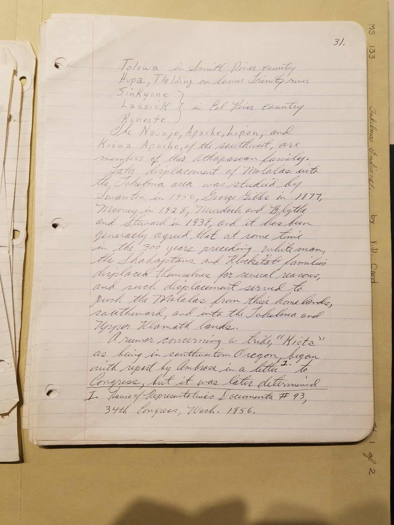
PAGE 31 LINK
Tolowa in Smith River Country
Hupa, Tlelding on lower Trinity River
Sinkyone, Lassick, Kuneste in Eel River country
The Navajo, Apache, Lipan, and Kiowa Apache, of the southwest, are
members of this Athapascan family. Later displacement of Molalas into
the Takelma area was studied by Swanton in 1950, George Gibbs in 1877,
Mooney in 1928, Murdock and Blyth and Steward in 1938, and it has been
generally agreed that at some time in the 300 years preceding white
man, the Shohaptans [sic]
and Klickitat families displaced themselves
for several reasons, and such displacement served to pus the Molalas
from their homelands, southward, and into the Takelma and Upper Klamath
lands. A rumor concerning a tribe, "Kiota" as being in southwestern
Oregon, began with report by Ambrose in a letter to Congress [House of
Representatives Documents #93, 34th Congress, Wash. 1856], but it was
later determined
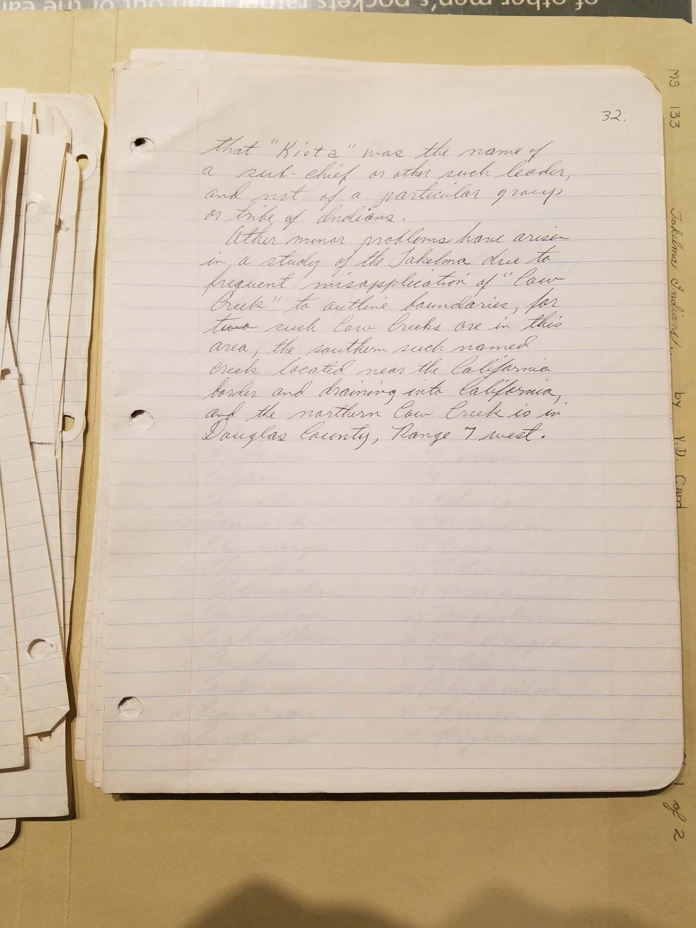
PAGE 32 LINK
that "Kiota" was the name of a sub-chief or other such leader, and not
of a particular group or tribe of Indians.
Other minor problems have arisen in a study of the Takelma due to
frequent misapplication of "Cow Creek" to outline boundaries, for two
such Cow Creeks are in this area, the southern such named creek located
near the California border and draining into California, and the
northern Cow Creek is in Douglas County, Range 7 west.

