|
|
Jackson County 1855 Travelers' descriptions and assessments of the state of things. For a visit to the South Coast from Crescent City to Coos Bay in October 1855--on the brink of war--click here. Also refer to Capt. T. J. Cram's report. 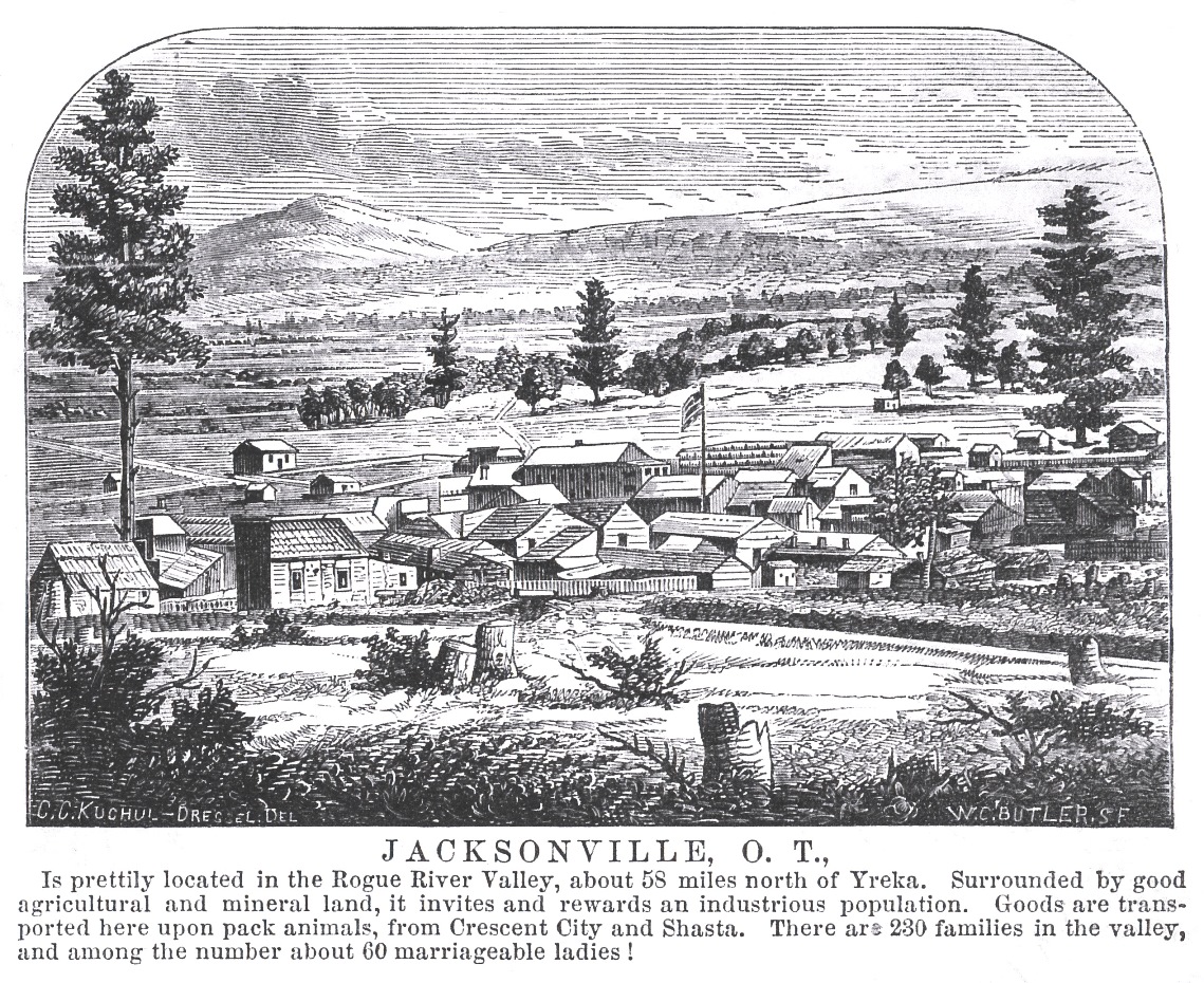
Jacksonville 1855, by James Mason Hutchings
Emigrant Road--Northern Route.
The Yreka Herald of the
6th inst. copies an article from this paper upon the emigrant road,
and over the plains mail stage route, in which state aid is invoked to
open roads over the Sierra Nevada, and to survey a route and locate
posts from here to Salt Lake, and gives the following observations upon
the extreme northern route. We were aware, from the reports of those
who have traveled it, that the pass into Siskiyou was one of the most
favorable yet discovered in the Sierra range, but that, after teaching
Yreka, it was next to impossible to get from that valley to the
Sacramento with a wagon. Whenever a good wagon road is completed from
Yreka to Shasta, that route will doubtless be extensively traveled by
those wishing to reach the head of the Sacramento Valley, or who intend
to locate in the rich mining region in Siskiyou, as well as by
emigrants desiring to settle in Southern Oregon. When the
subject comes fairly before the Legislature, this extreme northern route will be sure to receive its full share of attention. We
copy from the Herald:The above recommends "the improvement of at least three routes across the Sierra Nevada," and the "establishment of such trading posts and military stations as may be deemed necessary to supply and protect the emigrants." Now, in the north we have a route over which emigrants may reach California without any repair or outlay on the trail over the Sierra Nevada. There is no high mountain to cross, the ascent and descent, with the exception of about one fourth of a mile, is scarcely perceptible. The distance is not so great as that over any other northern route, and the entire road from the Humboldt abounds in the most luxuriant grass and good water. All we want on this route is the establishment of a military post on Clear Lake, and another on the Humboldt, to protect the emigrants from the Indians, and we have a route over which emigrants may reach this valley, the rich valleys in Southern Oregon on our north, or the Sacramento Valley on the south, without the necessity of losing a hoof of stock in consequence of bad road in want of food and water between here and the Humboldt. By the arrival of the next emigration, the wagon road between this place and the Sacramento Valley, via the Whortleberry Patch, will be completed, which will connect the great valleys of the Pacific. The emigrant trail intersects this road at Mount Shasta, and will ultimately be the route over which nearly all the stock and much of the emigration from the East, destined for the Sacramento Valley, must pass. The road across the Sierra Nevada, past Goose, Clear and Klamath lakes, and into Shasta Valley, is the only route into California on which good feed can be obtained all the way from the Humboldt, and on which the crossing of the Sierra Nevada is no obstacle. The rich and extensive mineral and agricultural resources of Siskiyou, Klamath and Trinity counties, in California, and Jackson County (or the Rogue River country) and the Umpqua ini Oregon, to which this road leads directly, and its many other superior advantages over every other route, cannot fail hereafter to make it one of, if not the greatest, thoroughfare across the Sierra Nevada, and one which can be traveled at all seasons of the year. Sacramento Daily Union, January 13, 1855, page 2
Wagon Roads.
Good roads and a ready communication from one
section of the country to another belong necessarily to
civilization. Barbarous nations are invariably found destitute of.
roads, or artificial means of communication. The ancients built
roads for military purposes, but for none other. The moderns build them
as necessary to extend commerce, expand its influences, and furnish
means of progress for humanity--for the million.In the mountain districts of this state, these arteries of the body politic depend for their creation upon human skill, capital, and energy. Nature had left the face of the country rough, rocky, and mountainous, but at the same time she has deposited under those mountains treasures of that gold which is another great civilizer of the race, and which the natural and artificial want of man force him to seek, at the expense of great labor and toil. Good roads, however, reduce this toil, and assist in developing the mineral wealth embedded in the mountains of California. Probably no portion of the state has been so severely taxed for lack of roads as the northern. The people there are literally without roads. Since its first settlement supplies have been furnished by means of the pack mule, and communication between points maintained by means of the same animal and "trails." For a few months past, the people in those regions have been striving to relieve themselves from these difficulties. Plans have been proposed for opening roads from Crescent City to Yreka, from the latter place to Shasta; from Shasta to Weaverville, and from Humboldt also, over into the eastern valley. There may have been others spoken of which have escaped our notice. But we have named enough to exhibit the intense interest which prevails in the northern portion of the state upon the subject of roads and turnpikes. Most of the enterprises projected would, we have no doubt, pay a first-rate interest on the money invested to build the roads, but the sparseness of the population in those counties renders it difficult to raise the amount of money requisite, and unless assistance can be obtained from individual capitalists in the more densely populated portions of the state, or from the state herself, there is danger that most of these enterprises will fail. So important do we conceive these road enterprises in developing the resources of the state in social, commercial, agricultural and mineral wealth, that if any plan can be devised by which the state can constitutionally aid, we should favor its adoption. The principle of aiding the building of good roads by means of state aid is founded upon the arguments which apply in favor of state aid for railroads and canals. The only difference is in degree. Our attention has been called more particularly to this matter by an article we find in the Crescent City Herald, and in reading the report of the engineer who surveyed a route for a turnpike road from that point over the Siskiyou Mountain, by means of which a good line of wagon communication would be opened from Crescent City to Yreka. Of the distance, cost, &c., the Herald says: "Between Crescent City and the fertile valleys of Northern California and Southern Oregon interposes the Coast Range of mountains, which is well known to extend all along the northern Pacific shore. In our neighborhood this mountain range is comparatively low and presents regular ridges over which a good road, only forty miles in length, may be carried into Illinois Valley. At present but a mule trail leads across the mountains, over which, during the year of 1854, not less than 4000 tons of merchandise have been carried at the rate of seven cents per pound or $140 per ton--making the enormous amount of $560,000 paid for freight. A wagon road would at least save half that sum. Is it to be wondered at that a company was formed under the provisions of the statute to construct a turnpike road? The company incurred an expense of over $2000 for a scientific survey of the route. The detailed report of the engineer is before us; the road is practicable at a maximum grade of one foot upon ten, and the greatest elevation reached is 3,567 feet above high tide water. A turnpike road eighteen feet wide can be constructed for some $85,000 on the present survey, while some of our citizens are sanguine that further explorations will show us a still easier and perhaps less expensive route." Upon the policy of expending money on the part of the state for opening roads in various parts of the state, and particularly over the Sierra Nevada, the Herald remarks: "We are a young state yet, and the country to a great extent devoid of good roads. A couple of millions judiciously expended in the construction of roads would double the taxable property in the state, and facilitate very much the acquisition of wealth and comfort to our citizens generally. It is neither wise nor necessary that the present should do everything, and hand down to the future a country adorned and provided with all the improvements and appliances of civilization entirely unencumbered. Those that will come after us will be able to pay tolls and taxes as well as we are, and even more so." It then proposed, in order to cover, as it were, the state with a network of good roads, that she lend her credit to the amount of two millions of dollars for that purpose. This plan is impracticable, simply because the constitution forbids it. One of the suggestions of the Herald to raise money to build their turnpike may meet a favorable consideration at the hands of the legislature. That body we believe is disposed to do all which can be done through the agency of the state towards furnishing good roads over the Sierra Nevada, as well as in other portions of the state. The Herald's suggestion is-- "That by an act of the legislature, Crescent City, as a corporation, on a two-third vote of her citizens, be authorized to subscribe $60,000, or an amount not exceeding two-thirds of the capital stock in an enterprise having for its object the construction of a turnpike road from Crescent City to Illinois Valley, and undertaken by citizens of this state in accordance with and under the provisions of the act passed May 12th, 1855, 'To authorize the formation of corporations for the construction of Plank or Turnpike Roads,' and that the city may thereupon issue bonds of $500 each, bearing 10 percent interest per annum, redeemable ten years after date." The road from the head of the Sacramento Valley to Oregon, by way of Shasta and Yreka, may be classed as a United States Military Road. In the event of a war, and the blockade of our ports, such a road would become of commanding importance in defending Oregon and California. In this view, the funds to build it should be furnished by the United States government. Further efforts may therefore be made with propriety to obtain from the United States an appropriation to assist in building this road. The company proposing to build it, in consideration of a certain sum, would guarantee its free use for government purposes for all time. Sacramento Daily Union, February 3, 1855, page 2 Cloudy and warm. From South Mountain House to "Eden" School Dist., Rogue River Valley, 22 miles. Had pretty good quarters last night at Cole's (M.H.). [illegible] Bear Valley is two miles north of Mountain House, from Cole's to Rogue River Valley--a distance of about 14 miles--the road is very heavy and clayey mud. The horse's feet when drawn out go off like corks from large bottles, such is the suction of the mud. At other times the water from an old hoof hole would squirt 6 or 8 feet above one's head when on horseback. Plug! Plug! Plug! would be the music. From Yreka to the Siskiyou Mountains there is but little timber (except in the distance), but having reached the summit in descending towards the Rogue River Valley the forest timber is very heavy and dense. How a stage gets over that road I can't say upon oath. I know that it was as much as my horse wanted to do to get along without my riding. When you get a distant view of the Rogue River Valley you are struck with the beautiful green slopes and clumps of oaks and pines on a rounding knoll here or there with the smoke curling up from one of those woody dwelling places. The mountains too (although on the northeastern side of the valley one without heavy timber) are beautiful from their singularity of shape and evenness of surface. The climate of this valley must be more moist than in California, as I see the grass roots do not die here from excessive drought, while every hill has a number of animals grazing on the top, for the grass is good although the snow has not been off the ground over a month. Met a lady sitting astride her mule the same as the two men with her. She didn't exhibit much of the beauty or ugliness of her understandings. I must say I like to see a neat ankle on a woman! She had one, and I of course had to admire, consequently, looked! The Siskiyou Mountain is easy and gradual of ascent and not very high. Met several pack trains laden with goods for Yreka, they having come by way of Crescent City and Jacksonville. Now, as the Rogue River Valley opens to the view, how beautifully diversified is the scene--with fine clear openings of rich, black soil just turned up by the plow, now the young wheat fresh and green peeping from the soil; here and there a small stream running down from the timber-clothed mountainside that would turn a mill or color the flower or give vitality to crops, here a small swell of land covered with oaks, there one of pines, yonder another with that beautiful evergreen the "manzanita" and other bushes. February 6, 1855 Cloudy--rain & cold in the morning--not much better evening. From "Eden" (or "Rockfellow's Tavern") R.R. Valley to Sterlingville, 12 miles. Was only charged $3.00 for myself and horse for last night!!! Good. Kept a-wending my way 'round fences and houses for about 4 miles further down the valley, when I left it following a trail towards Sterlingville, a much higher and more difficult mountain to climb than coming over the Siskiyou Range. Grass on every hill--good grass--and on the distant hills could see cattle grazing. Reached Sterling about 2 o'clock. This is a small town that has newly sprung up, the diggings not having been found more than 7 or 8 months, but there are now in the vicinity about 550 miners--about 20 families--no marriageable women--about 35 children. This is a busy little spot--the hillsides and gulches are alive with men at work either "stripping" or "drifting" or "sluicing" or "tomming" or draining their claims by a "tail race." Yet the water is thick with use, being very scarce, as a large number of men are using it. Here you see a prospector with his pick on his shoulder and a pan under his arm, and his partner coming along with the shovel upon his shoulder. That man yonder with the blankets at his back has just got in--he is now asking if you know anyone who wants to hire him. You tell him where you think he may live for a few days, and when that fails he will have money enough to buy himself some tools and set himself to work. There as everywhere the cry is water--water--"will it never rain"--yes--"they feel dull enough" for they can't make their board for want of water. They ask you "if the people at Yreka are doing anything yet?" "No," is your answer. They want water, the canal not being finished yet. Things are duller there than here. "Had I seen anything of a man named Brooks who was coming to see if he couldn't bring Applegate Creek to set the men doing something with the water?" No, I hadn't. "Well, he was a-coming." That's the talk, said I. This town is situated on Sterling Creek about 5 miles from its junction with Applegate Creek. The creek is about 8 miles long. February 7, 1855 Cloudy & a few drops of rain Down Sterling Creek to its mouth called Bunkumville [Buncom], 5 mi. Left Sterlingville to go down the creek for about a mile and quarter down. On the hillsides men are very busy the same as in town; many are doing remarkably well with the little water they now have. There is but little mining in the creek. Then further down you go for 2½ miles before you see anything being done--not a man to be seen--then a prospector or two, then a couple of men at work, then a company, then more prospectors. Then cabins are seen and in the distance a flag--perhaps a piece of old canvas tied to a pole (although sometimes the stars and stripes are floating proudly as if to say "walk in--there's liberty here--to get drunk if you have money or credit"). At all events it indicates a trading post. Opposite to that the rocks and the water and the pick or the shovel or the fork are rattling in or about the sluice boxes. People are all hard at work. What a contrast to some places. As I was looking and thinking how much these diggings resembled White Rock in El Dorado Co., a voice hailed me, "Why, how do you do Mr. H!" and a hearty grip of the hand from Jim Lamar, a man who worked for us at White Rock. It was rather a singular coincidence. The gold here is generally rough, not having been washed smooth by rolling as in some districts. I prophesied good hill diggings here same as at White Rock. February 8, 1855 Cloudy and dark. Rained ¾ an hour last night. Sterlingville. Last night it rained for about ¾ of an hour, and as I felt it pattering on my head I didn't approve of such an unfeeling course. I however moved further down in bed and covering my head with the blankets told it to rain on--but it didn't for long. Still it is an unpleasant situation, sleeping in the best hotel! of the place to find that when the rain can get at your head you feel its cold "fingers" down your back. Such is hotel accommodations here. There is moreover two women to cook, yet nothing fit to eat. Went without dinner rather than go to eat it. But then "they are from Oregon!!" The majority of the men here are those who crossed the plains last summer to Oregon and utterly disappointed had come on towards California. An inquisitive fellow inquired from me what state I was from. I told him I was a native of Pike Co. but had been raised in Oregon. "Oh! damn, damn, that must be hard" groaned he, but looking into my face he said, "I don't hardly believe you; it can't be." At this I burst out laughing and remarked that he must be from those "parts" to know that I was not!!! He then laughed and said "Get out!" Oregon people do not seem to be in good favor anywhere north. They are generally called "Wallah Wallahs," as a large portion talk the jargon of the Hudson Bay Co. February 9, 1855 Rained lightly all the morning, but held up at noon. From Sterlingville to Jacksonville, 8 miles. This morning it was rather unpleasant traveling in the rain; the road, however, is of a very gradual grade, but a large portion being through a timbered country, the roots across the road and on the ruts make it rather hard I should think for wagons. There are so many soft places near the roots and stumps a wagon has to cross. One fellow had taken himself up a ranch and was fencing up [i.e., across] the road--without in any way indicating any other way--and I accordingly got from my horse and threw down the fence at the trail. Men must be "darned" fools to suppose that strangers will spend their time hunting for a new trail when the plain one--with a fence across it--is just before him. I'll bet that fellow was from either "Pike" or "Oregon." It is too general sometimes turning teams a mile or two round and up a hard hill. About noon I reached Jacksonville
This is the county seat of Jackson Co., Oregon and was formerly called "Table Rock City."Diggings were first discovered near here in Feby. 1852 by Messrs. Clugage & Pool, who being on a prospecting tour found their labors rewarded by the discovery of good diggings. There were but three log houses in the Rogue River Valley then, for farming purposes. Messrs. C. & P. were digging a ditch to take water to the diggings. They had disc'd [discovered gold] and seeing some other men around discontinued work for about a month, but seeing the strangers about to locate they resumed their work and one and another would come and set to work and stay, hence arose the town so that now the population is about 700--22 families--and over 200 families in the Rogue River Valley. There are 53 marriageable [women] within a circuit of 12 miles of Jacksonville--9 within Jacksonville--35 scholars attend a day school kept by Miss Royle. Couldn't find the number of children in the valley. There are 10 stores, 3 boarding houses, 1 bowling alley, 1 billiard [saloon], 3 physicians (and 300 men called Doctor!), 1 tin shop, 1 meat [market], 1 livery stable--shame on it--1 church, 1 schoolhouse. February 10, 1855 Rain at intervals all day until evening, when it rained heavily 2½ hours. Jacksonville. This town is supported by the mines around and the wants of the agriculturalists. It is beautifully located in the Rogue River Valley about 10 miles above Table Rock. The houses seem mostly built of the tumble-down style of architecture. There is, however, one good brick store, built of lime [mortar] as it was dug out of the ground--natural lime. There seemed to me to be more Drs. by title than any other class. There seems a number of long-faced religionists--how blue and mean they look--they want credit, "hum" and "hah" and rub their hands and hang their head on one side as if deprecating their unworthiness to be a man--and so I should think they might, for a hog might suit their grubbing tastes better than the dignity of true manhood. I tarried at the Robinson House--the best building by far in town--went to bed about 1 o'clock, awoke by 3 men coming into my room. One lifted up the blankets to look in my face. "What's up?" I wished to know. "Oh, nothing." "Then don't you poke your nothings or your nose under my blanket anymore." "I was a-lookin' for a man." "Then why didn't you say so." Then in came 3 other men--all "liquored up." "Joe," said one, "hulloa, what do you want?" "I believe I am drunk--don't think I ought to be--do you Dr.?" (Everybody is Dr.) "Only had four 'cocktails.' I'm tight, sure I'm tight. Here, take my money." In the morning a gold watch was missing from another of the trio. They couldn't make it out. "Do you remember" (said the Dr.) "So and So offering to bet me his watch against mine that the sorrel mare would win? And I said, oh, no, mine is a better watch than yours. One of those fellows at the table must have taken it. Who were they? Why, there was Mr. _____ and Dr. _____ and Doc. _____" An inquiry was made from them and the barkeeper Dick and several others, but no gold watch or gold chain was forthcoming. By this time the one that confessed to being drunk found it underneath his hat upon the washstand, when downstairs he goes with the watch in his hand and saying that he thought that he was tolerably tight but he be blamed if the watch owner mustn't have been more so not to remember where he had put it. They then treated each other and were beginning to get a little tight again. This is the common failing of too many in Cal. February 11, 1855 Rain in morning, cloudy all day--except a few gleams of sunlight. From Jacksonville to North Mountain House, 22 miles. Anxious to avoid being rained in so far away from any point easily reached from our larger cities I started this morning and made along the Rogue River Valley, admiring its beautiful green slopes and timbered knolls. There are so many versions of the origin of the name of this valley, but I conclude the roguish disposition of the Indians is the true one--as seems more generally admitted. It is, however, a beautiful valley about 35 miles long and from ½ a mile to 20 miles wide and will average about 7½ miles in width. About 10 miles below Jacksonville is "Table Rock," a level and solitary elevation or rather elevations, as there are two, about 700 feet above the valley. Its length is about 350 feet by about 200 feet in width, at the base of which is situated the U.S. military post of "Fort Lane." It contains about 70 soldiers, and these have astonished and awed the Indians by throwing a shell to the top of Table Rock from the fort. This rock is a little east of north from Jacksonville. ----
Apples grown in
the Willamette Valley, O.T. were brought to Jacksonville in quantities
and sold wholesale at 90 cts. per lb. The small ones were retailed at
25 cts. each and the larger ones at 50 cts. each, but the largest sold
at a dollar. These were bought by Brown & Fowler of the El Dorado
Billiard Saloon. These gents seem fond of fun, and they exhibit a small
pistol--old-fashioned and rusty--to the "Wallah Wallahs" or greenhorns
of Oregon as a pistol said to have been given to Rousset de Boulbon for
self-destruction on the morning of his execution. They also exhibit an
old broken and rusty cutlass as the knife with which the head of
Joaquin Murietta, the California bandit and robber, was cut off with!!!
and point out some deep rust as blood that has eaten into the blade!!!
These old "fixin's" were picked up in Crescent City, Ogn., brought on
here for a frolic by the express boys, who also brought some printed
notices with an expressman with the latest news on tap!!!!February 12, 1855 Cloudy. Rain in evening. From North Mountain House to Cottonwood, 29 miles. Oh, horrible--horrible has been the road today. The road over the Siskiyou Mountains had enough before, is now from the recent rains much worse. Mud Mud Mud; horse drawing long corks for 10 miles--now he would only be up to his knees, now again he would be up to his belly, almost pitching you over his head by the suddenness of the descent, or throwing you over his tail backwards when his forelegs are out and his hind ones are in the hole. This may have been a good stage road, but I wouldn't think so now--it is the worst road I ever traveled.
Journal, 1855,
James Mason Hutchings papers, Library of Congress MMC-1892
Trip to Southern Oregon.
We have recently returned from a tour of six weeks, during which time
we have visited the greater portion of Southern Oregon. The country
lying below Corvallis, on the Willamette River, has been so often
described, and is so well known, that we shall not inflict upon our
readers a rehash of it. From Corvallis to the Calapooia Mountains, a
distance of some eighty miles, the country is diversified between broad
and rolling prairies and occasional belts of timber, principally oak,
pine and fir. On either side of the upper Willamette Valley, which
averages some fifteen or twenty miles in width, are the Cascade Range
of mountains on the east and the Coast Range on the west, whose rugged
crests and rocky summits present a bold and interesting as well as a
picturesque landscape of more than common beauty. The traveler or
admirer of nature's handiwork will find as he plods his way over these
extensive plains a constant changing of these distant views, with an
occasional glimpse through the notches of the mountains at some of the
numerous peaks, whose summits are covered with the eternal snows of
thousands of winters. This, together with the different appearance of
the sides of the numerous buttes which extend from the mountains into the valley, present a diversified appearance on the whole route."NOTINGS BY THE WAY." We found the country much more thickly settled than we expected to find it. The farms are generally half sections instead of 640 acres, which are so universally held in the lower valley. The soil is rich and productive, as is evidenced by the growing crops and the quantity of grass and vegetation which nature has abundantly spread over the whole surface of these beautiful plains. The first place of note above Corvallis, on the west side of the Willamette River, is Jennyopolis--where we found our old friend Dick Irwin, snugly located on a good farm with a good stock of goods, wares and merchandise, ready to trade or to receive his friends with a cordiality which makes the weary traveler feel as if he had found an oasis in a desert. Starr's Point, some distance further up, is located on Long Tom, a stream of considerable size, upon which there are good mill sites and other advantages which will make it, at no distant day, a densely populated country. Eugene City, the county seat of Lane County, is pleasantly located on high rolling ground, over which is scattered an occasional oak, as yet spared from the woodman's ax. There are adjacent to the town several large round mounds or hills of some one hundred feet in height, more or less. These hills are covered with scattering trees, which in the distance gives them the appearance of well-grown orchards. During our brief sojourn at Eugene City we had an opportunity of seeing the great majority of the people from the adjacent country, who came in to attend a public political meeting. The inhabitants appeared to enjoy the best of health, and carried the evidence in their physiognomies of possessing intelligence and happiness as well as thrift. There is at Eugene City an excellent hotel, kept by Heatherly & Bailey, where the wayfarer will find repose and quietness. From the number of stores and other places of trade we inferred there was considerable business done at Eugene City. From Eugene City to the Calapooia Mountains our route carried us over a fine farming and grazing country, well watered and timbered. Siuslaw can boast of one log house now, but may, in the future, number many more. A good day's ride carried us over the Calapooia Mountains, where we found a stopping place with Mr. Estes. The road over this mountain is comparatively in good order, and is one of the pleasantest mountain passes we have ever traveled in Oregon. There are but few difficulties in the way of calling it a good wagon road. Some of the ascents are rather steep for a common team to ascend with an ordinary load. After spending the night at Estes'--where we found a good bed and excellent accommodations--we left refreshed, and reached Jesse Applegate's at Yoncalla. Mr. Applegate is one among the early pioneers in Oregon, who has explored most of the mountain passes, rivers and forests throughout the length and breadth of Oregon in examining for routes and laying out roads as a surveyor. We found, as all will find, Mr. Applegate a very intelligent, hospitable, and somewhat eccentric gentleman, situated in a romantic place at the foot of Yoncalla Mountain, upon a large farm, well cultivated, with a good variety of bearing fruit trees, good buildings, outhouses, &c., which give his place the appearance of an old homestead. We spent the day with Mr. Applegate, and at his invitation ascended to the summit of Yoncalla Mountain, where we had a distinct view of the Umpqua and the Willamette valleys, as well as the whole surrounding country. The Umpqua Valley is a succession of hills and valleys with a great variety of scattering timber of different kinds, but mostly of oak. The whole valley is considered the finest grazing country west of the Rocky Mountains, besides being well adapted for agricultural purposes. From Yoncalla we followed down Elk River to its junction with the Umpqua at Elkton, where we struck the main traveled road leading from Scottsburg to Jacksonville. The route from Yoncalla to Elkton is mountainous and rugged, being simply a bridle path or trail most of the way. Elkton is the county seat of Umpqua County, recently located there by the legislative assembly. It is immediately at the junction of Elk River with the Umpqua, and surrounded by high, rolling prairies, thickly covered with grass and vegetation. From Elkton we took the road to Scottsburg. This is the best road of the same length we have seen in Oregon, and is creditable to those who contributed their means and labor in building it. This road, which was built by the inhabitants of Umpqua, intersects the military road about three miles above Scottsburg. Scottsburg is situated at the head of tidewater on the Umpqua, and at the highest possible point of navigation for any sort of watercraft. At this point the river becomes suddenly shallow and rapid, with occasional falls of several feet in a few rods. Unfortunately, at Scottsburg rival interests have brought into existence two towns, upper and lower Scottsburg, They are about two miles apart, both on the same side of the river, and both suffering in consequence of local jealousies and rival interests, which are entirely too common in Oregon. At this time upper Scottsburg appears to be doing the most business; yet it appeared to us the lower town would in the end have a decided advantage, from the fact that vessels can come there and no further without being favored by the tides. Mr. Allan, of the firm of Allan, McKinlay & Co., kindly proffered us a trip to the mouth of the Umpqua River, which is some twenty-five miles distant; we gladly accepted the liberality and kindness of Mr. Allan, and at an early hour we left, in company with several other gentlemen, on the steamer Washington. From Scottsburg, the Umpqua passes most of the way through a canyon of almost perpendicular rocks on either side of many hundred feet high. The scenery is grand and sublime--the river much larger than we expected to find it. There is but one obstruction, called Brandy Bar, to prevent any vessel engaged in the coast trade from ascending the Umpqua to Scottsburg at any stage of water--at high tide vessels drawing twelve feet pass over it. Umpqua City and Gardiner are situated near the mouth of the river. The custom house is located at Gardiner, some four or five miles from the ocean. We found A. C. Gibbs, Esq. the collector of the port, absent, but Mrs. Gibbs extended to us a cordial welcome, and provided a good dinner, which was relished by the whole party, whose appetites had become sharpened by the bracing sea breeze which we encountered below. After convincing Mrs. Gibbs that her dinner was duly appreciated we left upon our upward trip. On our way up we discovered a huge blacktailed deer deliberately walking down to the water's edge, when after drinking for a minute or so, plunged into the river and commenced swimming towards the other side. The captain of the Washington concluded to give chase with the steamer, and therefore put the helm hard up and headed his deership off the shore; after several tacks we finally succeeded in throwing a lasso over the horns of the deer, and bringing him up aside the steamer. It was then decided to bind the captive and take him to Scottsburg alive, which was finally accomplished after considerable difficulty. This is the first time, so far as we know, that a large, full-grown buck, in full strength, has been captured, bound and taken home alive and uninjured by even the Nimrods of Umpqua, who are celebrated as good deer hunters, At all events, it is the first time we ever hunted deer with success on a steamboat. The event created considerable excitement and much merriment to all on board. From Scottsburg we again visited Elkton, and from thence proceeded to Oakland. We noticed on the way one of the best arranged school houses we have seen in Oregon. It is built after the modern style of New England school houses--is well finished, painted and enclosed, and is a creditable monument to the intelligence of the people of the district. We advise other districts to go and do likewise. At Oakland there is a store and a post office, and a good farming country surrounding it. We visited Umpqua Academy, situated on the route from Oakland to Winchester. This academy was built under the supervision and by the efforts of Rev. J. H. Wilbur, who has done much to facilitate and provide the means of education in Oregon. We spent the night under Mr. Wilbur's hospitable roof, and received from him that kindness which he is accustomed to extend to all weary travelers who are without food or shelter. The academy is a fine large building, handsomely finished and pleasantly located in the midst of a beautiful grove, and bids fair to become one of the principal schools on this coast in a short time. Winchester is situated on the north side of the north fork of Umpqua River; there are several stores and machine shops, with mills nearby, where the inhabitants get their supplies. Deer Creek [Roseburg], a few miles further south, the county seat of Douglas County, is a place of considerable business, and is a pleasant location to live for those who admire the beauties of nature and enjoy a quiet life. The country from Deer Creek to the Canyon is one of singular beauty and possesses a rich soil, as was evidenced by the growing crops. This celebrated and never-to-be-forgotten "Canyon" (by those who have passed through it) we shall not attempt to describe, except to say that "the road" is the worst specimen of that name we have ever traveled over, and trust we may never see its like again. A portion of it is emphatically a canyon--a portion a mountain of unusual steepness, and the rest an unfathomable mud-hole, infinitely worse than the "slough of despond" as described by Bunyan. Portions of broken wagons, broken ox yokes and fragments of destruction to property are scattered along the way, from one end to the other, called 10½ miles in length--but which is a hard day's journey to get through it. Once through this canyon, the traveler will find himself in the valley of Cow Creek, which has a narrow interval of good tillable land for some distance where the road crosses and leaves it. We stopped at Mr. Turner's, who keeps an excellent house some eight miles from the south end of the canyon. From this to Jacksonville the road is comparatively good, except "Grave Creek Hills," and with here and there an occasional mud-hole for a short distance. We found good public houses at Grave Creek, also an excellent stopping place at J. B. Wagoner's, about thirty miles north of Jacksonville, also at the crossing of Rogue River. We found Rogue River Valley much more extensive than we had anticipated. It appeared to the eye to be thirty or forty miles long, and from twelve to fifteen broad, which is entirely occupied by settlers. There are a large number of well-cultivated farms, scattered over this whole valley. Jacksonville is situated on the south side, about midway of the valley, and is a place of considerable trade and business. It appears, like all mining towns, to have grown up suddenly. There are, however, a number of good buildings now going up. We noticed one brick store completed, and preparations making for the erection of others. The scarcity of water has stopped all mining operations or nearly so in the immediate vicinity. We visited Ashland Mills, some twenty miles further south, also Butte Creek, some twelve or fifteen miles east [north] of Jacksonville, both of which are pleasant locations. From Jacksonville we proceeded to Althouse, Canyon Creek, Sailors Diggings and back via Sterling. The whole route passes over a rough and mountainous country, with an occasional narrow valley along the small streams, on which settlers have located claims. Many of them present the evidence of good soil and a high state of cultivation. Upon all these streams there is gold to be found in greater or less quantities. We were told by all that miners could make from three to five dollars per day upon almost any of them. We found the miners doing well at Althouse and at Sailors Diggings, where they have sufficient water. At Sterling there is said to be the richest mines yet discovered in Southern Oregon, but the great scarcity of water has seriously checked all mining operations during the spring. The traveler will find an excellent stopping place at Thompson's, on Applegate, and at H. M. Hart's, at Sailors Diggings. We found our old friend J. W. Briggs the occupant of a fine farm in Illinois Valley, surrounded by many of the comforts of life. We were informed that there are several excellent claims yet untaken in Illinois Valley, as well as on Butte Creek and many of the small valleys extending far up into the mountains from Rogue, Applegate and Illinois rivers, &c. Jackson County, although very mountainous and rugged, will doubtless soon become one of the wealthiest counties in Oregon. She possesses considerable good tillable soil and a large quantity of excellent grazing country, in addition to her inexhaustible gold mines. We were accompanied through Southern Oregon by several gentlemen of opposite political creeds and sentiments, among whom were A. C. Gibbs, R. E. Stratton, S. F. Chadwick, Esqrs., and Dr. Drew, of Umpqua, Capt. Martin, of Douglas, Capt. Miller, L. F. Mosher, Esq., of Jackson, and others, all of whom we take pleasure in saying (with a single exception) we found honorable, fair, high-minded gentlemen, notwithstanding the scurrility and falsehoods which have appeared, and will continue to appear, in the Oregon Statesman in relation to this canvass. We also received from the masses of Democrats as well as Whigs throughout Southern Oregon, those civilities which make a man a gentleman, and which the editor of the Oregon Statesman and his echoes have never learned or cannot appreciate. Oregonian, Portland, June 23, 1855, page 2 Attributed to T. J. Dryer in the Oregonian of July 30, 1950, page 73 Roseburg, Douglas Co.
Dear BrothersO.T. Sept. 23rd 1855 I have an opportunity of writing you a line & take pleasure in saying that I am well. I recd. a letter from Jarvis, the date of which I do not remember, but it contained a large cut of the improved iron grass cutter & it affords me real satisfaction to learn that you prosper so well and also that Mother continues so well. Business in this country is extremely dull, the mines have literally gone in, although we have had & are now having a great excitement about the discovery of gold on the waters of the Columbia, some 600 [sic] miles to the northeast from Oregon City. One family in the next house, about 60 years old, start for there bag & baggage tomorrow. Many are going daily, & many returning cursing the diggings as they come. All agree that gold can be found in all the streams, & equally as good on the sides of all the hills & mountains. The most reliable reports are that men make with pans & rockers from $1 to $3 per day. The same diggings will pay by the improved mode of washing with sluices about three times as much & I doubt not that good-paying diggings will be found in that region next season. I had some thought of going there, but the season has advanced so far & the distance is so great & the snow falls so heavily during winter (in lieu of the rain here in the valleys) that I shall not go this fall & not in the spring, unless the prospects are very flattering. I see by papers from the States that gold mines have been discovered on the Red River near the borders of Arkansas, also from the Salt Lake Mormon settlement that mines have been found on Sweetwater River, & from accounts numbers were leaving Salt Lake for the place. I have also seen men who found gold in the Black Hills a little above Laramie & in the Wind River Mountains. Within two years we shall hear of the discovery of mines that will prove more extensive than any yet known, or at least such is my opinion. A party recently left here on a prospecting trip up this, Umpqua River. One man returned in two days from above the settlements & reports $4 diggings [diggings that yield $4 a day]; the others continued up the river and if not interrupted by Indians may find good diggings. The latter part of this, or the first part of next week, I am going with a party up the south branch of the Umpqua River in search of diggings. Some men that have seen the country have strong hopes of it. If I should find diggings that will pay on either branch of this river I think I had better remain here during the winter and meet Jarvis in San Francisco in the spring, but of this I will write you more hereafter. The rights for Oregon & Washington territories for the reaper had better be sold for what they will bring, more or less. Times are so hard & money so scarce that men worth large amounts of property find it difficult to do business & pay taxes; hence I think you would hardly be justified either in building here or bringing any large number of machines to sell unless you chose to sell on a credit. In California people have more money to do business with. California supplies herself now & Oregon sells her but little. The wheat crop was ruined by smut & grasshoppers, & what there is cannot be sold for want of purchasers. It has no price. Cattle are the only thing that will sell, & yet a few years longer will reduce the price of stock till it will be hardly worth raising, unless mines shall be discovered or some unlooked-for impulse shall be given to business here. I consider Oregon about done over. People here have been importing almost everything they use, while they expect nothing but money. Their money is exhausted; they are without manufactures of any kind, have for the last 2 years only had something to sell & there are no purchasers. So you can readily comprehend our situation. I have money due me here & cannot collect enough to take me to the States & back. . . . John C. Danford, letter probably written to his brother Ebenezer Danford (manufacturer of a mower and reaper) in Chicago. "Letters of John C. Danford, Oregon Territory 1847-1856," transcribed by Frank Richard Sondeen June 1961. Fremont Area District Library, Fremont, Michigan. The following report of the editor gives an account of this incident of his service, and a fair description of the country passed over by the escort and surveying party, the region (the Modoc country) in which years after the life of the gallant and accomplished soldier, General Canby, was uselessly and criminally sacrificed, through the wretched peace policy of the administration at Washington. The report was published in the Army and Navy Journal soon after the sad intelligence reached the East. Fort Lane, Oregon Territory, November 23, 1855.
Major E. D. Townsend, Asst. Adjt.-General, U.S.A.Headquarters Department of the Pacific, Benicia, California: Major:--Having already advised you of the fact of my arrival at this post, with a part of the escort of Lieut. Robert S. Williamson, Topographical Engineers, upon his recent survey and exploration, I beg leave to make the following report in relation to the expedition, but having no connection with its objects and results, as determined by Lieutenant Williamson. The detachment of Company D, 3rd Artillery (acting as infantry) and of Companies D and E, 4th Infantry, left Fort Reading under the command of Lieut. George Crook, 4th Infantry(1) on the 26th of July, with the pack train. I was detained at that post by severe indisposition until the 28th, when I started with the detachment (C and E) of the 1st Dragoons, under charge of Lieut. John B. Hood, 4th Infantry(2), and with Lieutenant Williamson's party. On the 29th we overtook Lieutenant Crook encamped at Macomber's Flats on Battle Creek, about thirty miles from Fort Reading. From this point our march was continuous and uninterrupted, save by such delays as became necessary to recruit our animals, to bring up the sick and stragglers of the command, and to enable Lieutenant Williamson to make reconnaissances of the country. Our route from Fort Reading to Canoe Creek lay across the western spur of the Sierra Nevada under Lassen's Butte, and a portion of it, together with that along Canoe Creek, through valleys and tablelands filled with confused masses of lava or pedregal, and thickly overgrown with manzanita and artemisia bushes. From its mouth to that of Fall River we passed through a mountainous country, characterized by the same pedregal formation, and the soil producing the same species of bushes, with here and there a scattered growth of pines. Crossing Pit River below and near the canon above Fall River (where Lieut. Hood left us and Lieut. Philip H. Sheridan, 4th Infantry, joined), and ascending a precipitous bluff, we saw but little difference in the features of the country. Above the cañon we passed into a broad bottom, producing a fine growth of grass, but abounding in pools of stagnant water, and through which the river flowed with a sluggish current. Except while following an emigrant trail, the soft and porous soil of the valley made our march a painful and fatiguing one to our over-packed animals and foot soldiers. Leaving Pit River at the point where it began to flow to the southward, we passed over an easy, though hilly, road and through a very picturesque country, and encamped in a beautiful little valley, watered by a fine little stream, about ten miles to north of the river. From this encampment we struck due north to Wright Lake, and thence to Rhett Lake and Lost River, the country presenting no attractive features, being mostly a barren waste, destitute of water and healthy vegetation. Along Lost River there are some few patches of fine grass, but for the greater part of the distance we traveled up to it, no other vegetation was to be seen except the artemisia or wild sage. Having crossed Lost River on its Natural Bridge, and ascending to the head of its southern bend, we struck across to Klamath Lake, and following its shores along the base of the hills we came upon the Klamath River. Ascending the river, after an easy day's march, we reached the lower extremity of the Great Klamath Marsh. We found in our course around the marsh several Indian rancherias, all of which were deserted by the inhabitants on our approach. Quite a number of the Indians, however, came into our camp in the evening, and the next day rendered us a great deal of assistance in crossing the river--guiding us to the ford and furnishing canoes to convey our packs. We marched twelve miles over marshy ground to a small stream--a tributary of the Klamath--and encamped, proceeding the succeeding day on our course towards the Deschutes River. Wherever, during the march, our route led us through pine forests, we found the ground thickly strewn with fallen timber, frequently compelling us to double the distance between the points of our route, and almost everywhere to make our own road, and but rarely finding hard ground to travel over. We reached the Deschutes River on the 26th August, and about thirty-five miles from the point where we struck it established a permanent camp, and Lieutenant Williamson proceeded with Lieutenant Sheridan and the dragoons to explore for a pass through the Cascade Range into the Willamette Valley. We joined him again on the 2nd September, and having established a depot camp in the vicinity of Snow Creek--a tributary of the Deschutes River--in the Cascade Range, about 120 miles south of the Dalles of the Columbia, Lieutenant Williamson started upon another exploration. Leaving Lieutenant Crook in charge of the camp, I proceeded with Lieutenant Abbott (Topographical Engineers) and the pack train to Fort Dalles to procure additional supplies for the expedition. The character of the country between Klamath Marsh and the Dalles has been so well described by Colonel Fremont in his report of his exploration of 1843-44 that I deem any further description in this report unnecessary.(4) We returned from Fort Dalles on the 23rd September, and Lieutenant Williamson having dispensed with the services of the artillery and infantry detachments (as an escort) in the further prosecution of his survey, I began on the 24th the return march by way of Fort Lane. Crossing the summit of the range in the vicinity of our camp, and passing in our route a series of beautiful lakes, with fine grass on their borders and shut in by magnificent forests of pine, we pursued (the course of) a small stream, which proved to be the main branch of the Deschutes River, and diverging from it after a few hours' travel reached the southern tributary of the same river, about ten miles above our first permanent camp. Here we came into the emigrant road leading into the Willamette Valley, and following up the southern branch of the river to its source we crossed the summit of the Cascade Range, and on the 1st October struck the headwaters of the main fork of the Willamette River. Our road led for sixty miles through a dense pine forest, with here and there open spaces, in which we found fine grazing for our animals, and crossed the river some thirty miles from where it entered the valley. Between our depot camp and the emigrant road we found the ground thickly strewn with fallen timber, and in many places very boggy. The road--opened by the emigration of 1853--enters the Willamette Valley and strikes the principal California trail near Eugene City. Proceeding up the valley we crossed the Calapooia Mountains and halted at Winchester on the South Umpqua River to recruit our animals.(5) Hearing there of the outrages committed by the Indians in the Rogue River Valley, I proceeded at once, notwithstanding the exhausted condition of my animals, and although many of my men were quite footsore, by rapid marches to Fort Lane, and reported on the 17th October to the commanding officer of the post. The subsequent movements of the command are already known to the commanding general, and it is therefore unnecessary to state them here.(6) I am informed that it is in contemplation to establish a new (military) post in the vicinity of Pit River, and after carefully observing the country I beg leave to suggest two locations, which, I think, would answer the purpose of overawing the Indians living upon that river, whose reputed bad character and unfriendly disposition has not been exaggerated, judging from the bold and impudent behavior of the few who visited our camps. The first location that I would recommend is to be found in the vicinity of the mouth of Canoe Creek. There is an abundance of timber for building purposes--fine meadows of grass, and sufficient arable lands for gardens. There is an elevated plateau, back from the river, extensive enough to afford a good and healthful site for the post--above the malaria, if any there be, arising from (the river). Above the junction a few miles, the creek has a descent of two hundred and fifty feet in half a mile, forming a succession of beautiful cascades, and between them and the river a good location for a post can undoubtedly be found. The distance to Fort Reading is about eighty miles, and from the point where the emigrant road leading under Lassen's Butte crosses Canoe Creek a good wagon road can easily be constructed. The second point I would suggest is on the Oregon trail about ten miles due north of the southern bend of Pit River. There is a fine stream of water running through a pretty little valley, surrounded by a forest of excellent pine timber, and affording fine grazing for animals. A post located here would be sufficiently near Pit River to keep the Indians there in check, and has also the advantage of being within reaching distance of the Indian rancherias on and near Rhett Lake. It is about one hundred and seventy-five miles from Fort Reading by our traveled route, but there is, no doubt, a much shorter one. This, I am confident, would prove to be the most healthful location for a post in the neighborhood of Pit River. Before closing this report, I deem it my duty to mention the fact that the escort was, at the outset, provided with an insufficient number of pack animals to transport the necessary supplies and outfit of the command, and that, in consequence, it became necessary on leaving Fort Reading to pack the animals as heavily as three hundred pounds each, and even then, although a portion of the command was still behind, animals had to be sent back to Fort Reading from Macomber's Flats, to bring up stores left behind for want of transportation. It was not until the command had reached the Deschutes River that our packs became reduced to an average of two hundred pounds each--fifty pounds more than they should have been at the start, considering the nature of the country to be traveled over, and the important objects of the expedition. As a consequence, much delay was occasioned by necessary stoppages to recuperate our animals, while many have been seriously injured and quite a number have been, or eventually will be, lost to the government. Our progress was also greatly retarded by the foot troops, many of whom were at times suffering from chills and fever and diarrhea, and very frequently my rear guard was compelled to encamp at night with the sick, without water and a scarcity of provisions. Pack animals, already overtaxed, had often to be sent back to bring the sick into camp, rarely reaching it until long after nightfall. Owing to the overweight of the packs, I was unable to provide even the sick with animals to ride, when a long march became necessary. I have the honor to be, Major Very respectfully Your obedt. servt. H. G. GIBSON First Lt. 3rd Art. Commanding Escort to Lieutenant Williamson's Surveying Expedition(7) (1) Major-General during the War, and now Brigadier-General in the Army. (2) General in the Confederate Army--now deceased. (3) Lieutenant-General in the Army. (4) Whilst passing through this region, one afternoon Henry C. Fillebrown (one of the assistants of Lieutenant Williamson) and the editor left the trail which the party was following and took another which led down the Deschutes River. Night began to descend upon us with scarcely a warning of its approach, and we were ignorant of how far the trail taken by the troops diverged to the west, or of what obstacles lay in our path in the direction of the night's camp. We had no provisions in our haversacks, our supplies being limited to pipes and tobacco, revolvers and cartridges. Just at dusk we struck a deep tributary of the Deschutes, on the north side of which we saw a westerly trail. The banks were steep, and our mules refused to encounter the watery flood that ran like a torrent. So, whilst the editor, standing in the rapid stream, pulled on the bridle of his mule, Fillebrown struck the animal with a saber in the rear, which forced him to plunge into the flood, and in like manner we succeeded in effecting the passage of the stream by Fillebrown's quadruped. We found a well-beaten trail, and our hungry animals, scenting the camp afar off, trotted along briskly until we reached the camp, several miles distant, and our prospects of passing the night in an Oregon forest without food or covering vanished, to our great delight. We removed our drenched clothing and comforted the inner man with a hot beverage of stimulating waters and a warm supper. On another occasion, the editor, just as we were about to establish a camp for the night, drove his spurs into his mule to make him jump a small stream about five feet wide. The mulish animal, feeling his feelings hurt by the touching spur, lifted up his voice and wept, limbered to the rear, and his outrider passed beyond the stream--but not the mule. (5) Here the editor met his old friend and quondam comrade of Puebla, Mexico, Captain La Fayette Mosher--since a member of the Board of Visitors to West Point, 1884. (6) No report of these operations, excepting a field return of the troops, was ever made by Capt. A. J. Smith. (7) Of the members of this expedition, Lieutenant Sheridan became, as stated, General of the Army; Hood, a distinguished General of "The Lost Cause," and Crook, Brigadier-General in the Army; Williamson and Abbott became Lieutenant-Colonels of Engineers, the former deceased and the latter a Major-General by brevet; Fillebrown became a Captain and Asst. Adjutant-General of Vols., and is now deceased; C. D. Anderson entered the service of the Confederacy, and was last seen by the editor in 1865; Young, the draftsman, since unheard of; Jacob Brown Vinton has not been heard of since 1860; and Jacob R. Daniel, the handsome, the gallant and true-hearted, succumbed in 1861 to that terrible disease, whose wasting, consuming hand never withdraws its fatal touch. Horatio Gates Gibson, transcribed from a reprint in the collections of the U.S. Military Academy Library, West Point. Serialized in the Medford Mail Tribune April 13 (page B1), April 27 (page B1) and May 4, 1930 (page B5). The beginning of the article can be found transcribed here. CASCADE
MOUNTAINS, IN OREGON TERRITORY.
The
Cascade Range, in Oregon, consists of a belt from thirty to ninety
miles in width of pine- and fir-covered ridges, separated from each
other by a network of precipitous ravines. A line of isolated volcanic
peaks, extending in a direction nearly north and south through the
Territory, rises from this labyrinth, and marks the extreme western
border of the elevated plateau already described. The chief summits are
Mount Hood, Mount Jefferson, Mount Pitt and Diamond
Peak, which, with the four buttes composing the group called the Three
Sisters, tower high above the rest into the region of eternal snow, the
lower limit of which is here about 8,000 feet above the sea. The other
peaks, although quite prominent when seen from the plateau, are hidden
by intervening ridges from the Willamette Valley.Westward from this line of volcanic peaks, an abrupt slope, mostly composed of ridges of very compact slate, separated by immense cañons, descends to fertile valleys, elevated but slightly above the sea level, and extending to the foothills of the Coast Range. Near the watershed are numerous lakes, some of which discharge their waters towards the east, and others towards the west, by cañons so enormous that words fail to convey an adequate idea of their size. One, the side of which was so precipitous that we could only make the descent with the greatest difficulty, was found by actual measurement to be 1,945 feet deep. A few small prairies covered with excellent bunchgrass lie hidden among the mountains. They are often surrounded by bushes bearing a kind of whortleberry, called "oo-lal-le" by the Indians, who come in large parties in August and September to gather and dry them for winter use. Hence, it frequently happens that the explorer, while following a large trail which he hopes may lead across the mountains, suddenly finds it terminate in a whortleberry patch. An examination of these mountains is very difficult. The ravines, filled with thick underbrush interlaced with fallen timber, are, many of them, utterly impassable; the ridges are very precipitous and rocky; generally the thick forest of pine, fir, spruce and yew quite conceals the surrounding country, and the great scarcity of grass for the animals is a source of constant anxiety. According to the best information which I could gather from Indians and settlers, the whole range is covered with snow during the winter. There are six known passes through the Cascade Range, in Oregon Territory. It must be borne in mind that they are not simple gateways, but long, winding courses through a labyrinth of ridges and ravines. They will be described in their order of succession, beginning at the most southern. 1. Pass south of Mount Pitt.--This pass, through which an emigrant wagon road has already been constructed, was not examined by our party. Lieutenant Williamson followed the road to the point where it enters the mountains, near Camp B, on Klamath River. It strikes Stuart Creek, in Rogue River Valley, not far from Camp 78A. The air-line distance between these camps is only 32 miles, and the road is said to be very good, for a mountain route. 2. Pass south of Diamond Peak.--A wagon road has been constructed through this pass also, by which Lieutenant Williamson crossed the range. The approach from the eastward is by a branch of Deschutes River, that rises near the foot of the main ridge. About 20 miles after leaving this stream, the road strikes the middle fork of the Willamette River, the course of which it follows to the settlements. Where it passes over the main ridge, the road is very mountainous in its character, and in the ravine of the middle fork it crosses the stream many times at deep and rocky fords. There is a scarcity of grass upon the route. 3. New pass south of Mount Hood.--This pass was discovered by the detached party in my charge. As I believe it to be more favorable for a wagon road than any of those previously known, I shall describe with considerable minuteness, both the pass proper, through the main ridge, and the approaches to it from the east and the west. This division is adopted simply for ease of description. By far the greatest difficulty in the passage of the range was encountered in the western approach to the pass. *
* *
CALAPOOYA
MOUNTAINS.
This name
is given to a chain extending from the Cascade to the Coast Range, and
separating the Willamette and Umpqua valleys. It is composed of low
ridges, most of which are heavily timbered with spruce, pine, fir and
oak. A kind of hard sandstone is the prevailing rock.There are three wagon roads across these mountains. Two of these, the Applegate and Scott roads, pass over high and steep hills. The third, which is located between them, and which was not fully completed when my party passed over it, follows Pass Creek through the mountains without encountering a single hill. UMPQUA
VALLEY.
The
principal branch of the Umpqua River, called the South Umpqua, rises in
the Cascade Mountains near Diamond Peak. At first its course is
westerly. In longitude about 123° 15', it bends abruptly
towards the north, and after flowing about 75 miles in this direction,
and receiving the waters of the North Umpqua River and Elk Creek, it
again turns towards the west, and discharges itself into the Pacific.
The most valuable and populous portion of the valley lies near the
river where its course is northerly. This region consists partly of
small open prairies, and partly of rolling hills sparsely covered with
oak, fir and other kinds of trees. Much of the land is exceedingly
productive. The valley, at present, contains many scattered houses, but
very few towns.UMPQUA
MOUNTAINS.
Little is
known of this chain of mountains, except that it extends westward from
the Cascade Range nearly to the ocean. It consists of ridges from
2,000 to 3,000 feet in height, covered with thick forests and
underbrush. The rocks are mostly talcose in character. The only road
through the chain follows the Umpqua Cañon, which is fully described in
Chapter V, under the date November 1. Cow Creek rises south of the
mountains, and flows through them to the South Umpqua, but its cañon,
although followed by a pack trail, is reported to be too narrow and
precipitous for a wagon road. The chain has been crossed at other
places by parties with animals, and it is not improbable that a good
pass might be discovered by a thorough exploration.ROGUE
RIVER VALLEY.
Rogue
River rises in the Cascade Range, near Mount Pitt, and flows westward
to the Pacific Ocean, receiving on the way numerous small tributaries
from the Umpqua and Siskiyou Mountains. Some of these streams flow
through fertile valleys, separated from each other by high and
forest-clad hills. Others, especially those near the coast, are sunk in
immense cañons. Most of the rich land lies near the California and
Oregon trail. Gold digging is profitable in many places. Hornblende and
granitic rocks predominate, but Table Rock, and other hills in the
vicinity, are basaltic. Jacksonville is at present the only town in the
valley, although there are many scattered dwellings.SISKIYOU
MOUNTAINS.
Very
little is accurately known about this chain, although it has been much
explored by gold seekers. It is a high and heavily timbered dividing
ridge between the waters of Rogue and Klamath rivers, and its general
direction is east and west. The prevailing rock is a hard kind of
conglomerate sandstone. Near the summit, elevated about 2,400 feet
above the base, we found the soil to be an adhesive clay, which, when
wet, renders traveling very laborious. There are several pack trails
across the chain, but no reliable information concerning them could be
obtained.KLAMATH
RIVER AND ITS TRIBUTARIES.
Klamath
River, as already stated, rises in the great plateau east of the
Cascade Range. After flowing through Klamath Marsh, and upper and lower
Klamath lakes, it breaks through the mountains near Shasta Butte, and
following the southern base of the Siskiyou chain, discharges itself
into the Pacific. Through the greater part of its course it flows
either through sterile tablelands or immense cañons. Gold is found in
many places upon its banks. My party, while returning to Fort Reading,
passed through the valleys of Shasta, Scott's and Trinity rivers, three
of its most important tributaries. These will be described in the order
in which they were examined.Shasta Valley is an undulating region, about 25 miles in length and 15 in breadth, which extends from the base of Shasta Butte, in a northwesterly direction, to Klamath River. A small stream, named from the butte, traverses it. This valley is sterile compared with most of those already described, but the thick growth of bunchgrass renders it a fine grazing country. It is for its gold, however, that it is chiefly valuable. This metal is found in large quantities; but mining is difficult on account of the scanty supply of water. To remedy this deficiency, the miners are now digging a ditch from a point near the source of Shasta River, along the base of the hills which bound the valley on the southwest, to the river again near where it discharges itself into the Klamath. This ditch, which is called the Yreka Canal, will be, when completed, between 30 and 40 miles in length. It derives its name from the great depot of the northern mines, which is situated in so rich a portion of the valley that gold is dug in the very streets of the city. Scott's River flows nearly parallel to Shasta River, being only about 18 miles further to the west. The character of its valley, however, is widely different. Gold digging is not generally profitable in it, although some rich mining claims have been discovered; especially at Scott's Bar near the mouth of the stream. Most of the land is very productive, and a large portion of the valley is now divided into farms, the produce of which finds a ready market at Yreka and the mines. The greater elevation above the sea renders the climate much colder than that of the valleys further north. Frost has been known to occur here in every month of the year. Trinity River rises near Mount Shasta, and, after making a great bend to the south, discharges itself into the Klamath River, of which it is the largest tributary. My party, starting from its headwaters, followed down the stream for about one quarter of its length. It flowed through a deep ravine, bounded by high and timbered ridges. The bottom was so narrow that there was very little arable land. A short distance below the point where we left the river, it enters an immense cañon, which extends without much interruption to its mouth. SHASTA
BUTTE AND THE MOUNTAIN CHAINS OF NORTHERN CALIFORNIA.
Shasta
Butte, by far the most striking topographical feature of northern
California, rises abruptly to a height generally estimated at 18,000
feet above the sea. The peak is double, and both summits are rounded,
massive and loaded with eternal snow. Its white cloud-like form is
distinctly visible from points in the Sacramento Valley, more than one
hundred miles distant. This butte is not only the largest and grandest peak of the long range which divides the sterile interior of the country from the fertile valleys of the Pacific Slope, but it is also a great center from which diverge the numerous chains that render northern California one mass of mountains. In approaching it by the Oregon trail, both from the north and the south, there is, independent of the high ridges, a gradual increase in the elevation of the country for about 50 miles. The region near the base itself thus attains an altitude of about 4,000 feet above the sea; and it is an interesting fact that most of the northern mines are found upon this vast pedestal of the giant butte. Great confusion exists in the nomenclature of the mountain ranges in the vicinity. The name Cascade Mountains ceases at Klamath River, but the range in reality divides. One branch, called the Siskiyou Mountains, bends westward nearly to the coast; the other, under the name of the western chain of the Sierra Nevada, winds to the southeast and unites with the main Sierra Nevada. From the Butte, three steep and thickly wooded ridges called Little Scott's Mountains, Scott's Mountains, and Trinity Mountains, extend to the westward. The two latter are branches of the Coast Range of California. Shasta Butte, although generally considered a peak of the western chain of the Sierra Nevada, is, in truth, the great center from which radiate, besides several smaller ridges, the Cascade Range, the Coast Range, and the western chain of the Sierra Nevada. Lieutenant Henry L. Abbott, Reports of Explorations and Surveys to Ascertain the Most Practicable and Economical Rroute for a Railroad from the Mississippi River to the Pacific Ocean, Washington 1857, pages 30-36 ROUTE
FROM VANCOUVER TO FORT READING,
October 22[, 1855].--Today
we left Oregon City, traveled about eighteen miles over an excellent
road and encamped on Pudding River. The country was level or gently
undulating, and much of it covered with timber. We found the ford of
the Molalla River rather deep. A ferry boat is required at this
crossing during the season of high water. Numerous houses and fine
farms were passed on the way, and the land appeared fertile and
valuable.WEST OF THE CASCADE MOUNTAINS. October 23.--This morning we crossed Pudding River by a toll bridge and then traveled about twenty-four miles to Salem. Our course lay through a level country called French Prairie, the fertility and thickly settled character of which strongly contrasted with the barrenness and solitude of most of the Deschutes plateau. At Salem I saw the surveyor general of the Territory and Mr. H. Gordon, deputy surveyor. To both of these gentlemen I am indebted for much valuable information and personal kindness. October 24.--This morning it rained. We passed over the Willamette River at Rice's ferry, where the stream is deep and wide and the current rapid. One of our mules was drowned in attempting to swim across. We found difficulty in keeping our proper course today, on account of numerous forks in the road. There is also a very annoying custom, in this part of the valley, of enclosing by fences portions of the road with the land on each side, thus rendering large circuits unavoidable. Soon after leaving Salem we passed through a small collection of houses named Cincinnati and crossed a little stream called La Creole River. The country was level or slightly undulating for the whole of the day's march. We encamped on Luckiamute Creek, having traveled about seventeen miles. October 25.--The route today, which was in some places well timbered with oak, cedar, fir and spruce, lay over a narrow and nearly level plain, bordered by high hills. We passed through Corvallis, a little town, consisting principally of one street lined by several stores and dwelling houses. It is built on a small stream called Mary's River, which rises near a peak of the Coast Range bearing the same name and discharges itself into the Willamette. We traveled 32 miles and encamped on Long Tom Creek. October 26.--Today we continued our course through the same narrow, level prairie for 24 miles to Eugene City, a small village near the junction of the Coast and Middle forks of the Willamette. A short distance north of the town a line of low rolling hills, the principal peak of which is called Spencer's Butte, crosses the valley and connects the Cascade and Coast Ranges. October 27.--Our road today followed up the Coast Fork of the Willamette, and we encamped near its headwaters, after a day's march of about 25 miles. The valley had become narrow and we occasionally crossed low hills. The soil was very fertile, and much of it cultivated. We experienced no little difficulty, however, in obtaining forage for our animals, as the Indian war in Rogue River Valley had caused it to be in great demand. October 28.--Today we crossed, by the Pass Creek road, the Calapooya Mountains, which separate the Willamette and Umpqua valleys. Pass Creek rises in a little meadow, which is also the source of a tributary of the Coast Fork of the Willamette and flows through the Calapooya Mountains to Elk Creek, a branch of the Umpqua River. This pass had only been known for a short time, and the wagon road was not fully completed when my party traveled over the route. Nothing but a few short bridges and a little grading, however, was wanting to make it a good and level road through the mountains. Having reached the Umpqua Valley, we crossed a small divide between Pass and Elk creeks and traveled towards the south through a narrow prairie bordered by rolling hills. The soil was fertile, and the neatly painted houses, surrounded by cultivated land, greatly resembled those of the eastern states. We encamped near the end of this prairie, after a day's march of about 19 miles. October 29.--On starting this morning we passed over a steep hill with a flat and nearly level summit and then traveled to Winchester, distant about 19 miles from camp. Our course lay through an undulating and very fertile country, varied with an occasional growth of oak and pine. Winchester is a little town situated on the southern bank of the North Umpqua River, at this point a rapid stream about 80 feet in width, flowing over a very rocky bed. We crossed it in a ferry boat and encamped in the village during a heavy fall of rain, which continued through the night. October 30.--We learned, upon good authority, that the reports from Rogue River had not exaggerated the Indian disturbances there. None but strong parties could pass through the valley, and most of the houses north of the river were burned. A large force of regular and volunteer troops was already in the field, and two additional companies were about starting to reinforce them. The election of field officers was to take place immediately at Roseburg, and we remained in camp today to await the result, before applying for an escort to Fort Lane. I repaired a barometer. October 31.--This morning the road lay through a nearly level and very fertile valley to Roseburg, where I saw Major Martin, the elected commanding officer of the volunteers. He informed me that the troops were now fighting with the Indians near the Umpqua cañon and that he intended to join them on the following morning, with two more companies at present in camp at Canyonville. He kindly proposed to escort my party through the cañon, and I accepted his offer. We continued our course up the valley of the South Umpqua River and encamped with the volunteers near the northern entrance of the Umpqua Cañon, at Canyonville, which consists only of one house and a barn. The road followed the stream for the greater part of the way, and the valley, although narrow, was settled and much of it apparently very fertile. The hills on each side were lightly timbered with oak and fir. Several specimens of a hard variety of talcose slate were found during the day. The distance traveled was about twenty-six miles. In the evening a dispatch was received from the battlefield, stating that the troops were greatly in want of food and powder and urging on the reinforcements. In the night it rained. November 1.--This morning we followed the volunteers through the cañon, a difficult pass through the Umpqua Mountains. Two small creeks head near the divide and flow, one towards the north to the south fork of the South Umpqua and the other towards the south to Cow Creek. The bottom of the gorge is exceedingly narrow, and the precipitous sides, covered with a thick growth of trees, rise at least 1,000 feet above the water. We found in the cañon a species of yew tree which we did not notice elsewhere west of the Cascade Mountains. The ascent from the camp to the divide was 1,450 feet, and we were compelled, after crossing the creek about thirty times, to travel part of the way in its bed. A few resolute men might hold this defile against an army, and it is wonderful that the Rogue River Indians, who are intelligent, brave and well armed with rifles, have never, in their numerous wars, seized upon it and thus prevented the approach of troops from the Umpqua Valley. This pass is about eleven miles in length, and communication through it is sometimes interrupted by freshets. The road over which we traveled was constructed in 1853, by Brevet Major B. Alvord, United States army, and it is the best route known through the Umpqua Mountains. We had hardly left the cañon when we began to see traces of the Indian devastations. Blackened and smoking ruins, surrounded by the carcasses of domestic animals, marked the places where, but a few days before, the settlers had lived. We passed a team on the road; the oxen lay shot in the yoke, and the dark blood stains upon the seat of the wagon told the fate of the driver. Even the stacks of hay and grain in the fields had been burned. After leaving the cañon, we followed the narrow but fertile valley of' Cow Creek for a few miles and then crossing a steep divide between it and Wolf Creek, encamped on the latter stream. Major Martin intended to proceed, in the morning, to join in the battle which was going on among the mountains, at a distance from the road variously estimated to be from five to twelve miles. As he could not spare us an escort, we determined to press forward as rapidly as possible towards Fort Lane, trusting that the Indians would be too busy to attack our party. In the evening, however, stragglers from the fight began to come in. They reported that the provisions were entirely exhausted and the powder nearly gone; that the Indians were numerous and very strongly posted; that several while men had been killed and many wounded and that it had been thought best to fall back for the present and wait for supplies. The regular troops were on their way to Grave Creek, and the volunteers were coming to our camp as fast as they could transport their wounded. The Indians did not follow them, and they all arrived before morning. The forage on the route had been burned, and our animals suffered much from want of food tonight. November 2.--This morning Major Martin, escorted by a volunteer company, went to Grave Creek to see Captain A. J. Smith, 1st Dragoons, commanding the United States troops in the valley. He offered us the benefit of his escort, and we accompanied him accordingly. This gentleman, together with Captain Mosher and other volunteer officers, assisted us in every way in their power, and without this accidental aid our party would have found it very difficult to cross the valley. Wolf and Grave creeks are separated by high and steep hills, covered with thick timber and underbrush. On reaching Wolf Creek we found Captain Smith in camp, near a house surrounded by a small stockade. His supply of forage had failed, and he was forced, on this account, to prepare to return to Fort Lane as soon as a few men, who had died of their wounds, could be buried. Lieut. Gibson, formerly in command of the escort of our party, was among the wounded. Being compelled by want of forage to press forward as fast as possible, I applied to Capt. Smith for an escort. He gave me one so promptly that in less than fifteen minutes we were again on our way. Between Grave and Jumpoff Joe creeks the road passed over a steep and heavily timbered divide. The Indians had killed two men in charge of a pack train on this hill, and the half-burned remains of their wagon and packs were still to be seen. Near this place Major Fitzgerald, 1st Dragoons, had overtaken with a scouting party and killed several of the savages. At Jumpoff Joe Creek, a man driving swine had been murdered, and a large number of his animals lay dead in the road. On leaving this creek, we passed through an undulating and fertile country, sometimes open and sometimes thinly covered with a growth of oak, sugar maple and a little pine and hemlock. After traveling until nearly sundown, we encamped at a building which had been preserved from the general ruin by the heroism of a woman named Harris. After her husband had been murdered and her daughter wounded, she had made a desperate and successful defense by shooting at the savages from between the crevices of the log house. The traces of her bullets upon the trees, which had shielded the Indians, and the marks of the tragedy within the dwelling, were plainly visible. Soon after dark a small party under the command of Lieut. Allston, 1st Cavalry, arrived with the wounded and encamped. Captain Smith, with a few men, passed us on his way to Fort Lane. The length of our day's march was about fourteen miles. November 3.--Today we traveled about twenty-five miles to Fort Lane, crossing Rogue River at Evans' ferry. His house, and others south of the river, were now protected by a few soldiers. The disturbance had been confined to the northern side of the valley, and a few murders had been committed on the Siskiyou Mountains, and the settlers were in great alarm. The road was gently undulating until we arrived at the ferry, and from that point it followed the level bank of the river nearly the whole distance to Fort Lane. The land appeared to be rich and valuable. The hills were thinly covered with oak, pine and other kinds of trees. A short time before reaching the fort we passed\a salt spring, at which the animals drank eagerly. November 4.--Today we remained in camp to recruit the animals, which had suffered very much from fatigue and hunger during the last few days. We were treated with every possible kindness and attention by the officers stationed at the post. Fort Lane, at present a cavalry station, is pleasantly situated on the side of a low hill, near the junction of Stuart Creek with Rogue River. The barracks and officers' quarters are built of logs plastered with clay. Much of the surrounding country is fertile and settled, but destructive Indian outbreaks are not unfrequent. On the opposite bank of Stuart Creek there are some peculiar basaltic hills, with flat tops and precipitous sides, somewhat resembling those of the Deschutes Valley. The principal one, which is about five hundred feet high, is called Table Rock. Good observations were obtained at the fort, by which the altitude above the sea was found to be 1,202 feet and the latitude 42° 25' 56". November 5.--This morning we continued our journey without an escort, as no Indian outrages of importance had been recently perpetrated on the route. We found many houses deserted, however, and great alarm prevailing among the settlers. After traveling about 26 miles up the valley of Stuart Creek, we encamped at the house of Mr. Smith, near the foot of the Siskiyou Mountains. The road was level, and the general appearance of the country was similar to that near the source of the Willamette River. The rolling hills that shut in the valley were sometimes bare and sometimes thinly covered with trees. We passed, on the way, a hot spring, the temperature of which was about 100° Fahr. A continual escape of gas through the water gave it the appearance of boiling. November 6.--This morning we crossed the Siskiyou Mountains. At first the ascent was gradual, and the road soon began to wind up a steep slope, portions of which were rendered very slippery by clay and rain, until, at length, the summit, elevated 2,385 feet above camp, was attained. Here the mountain was densely timbered, but near the base there were comparatively few trees. The descent, for a short distance, was very abrupt, and it soon became gentle and broken by a few hills. A pile of stones by the roadside marked the boundary between Oregon and California. When we passed this spot it was raining, and in the valley below clouds of' dust gave evidence of a long-continued drought. The rainy season begins earlier in Oregon than in California, and it happened in several places that the first rain of the season occurred on the night of our arrival. Nature seems to have preceded legislation in making the Siskiyou Mountains a boundary, for, after passing them, the appearance of the country immediately undergoes a change. Rounded and nearly bare hills, not unlike those of the Sacramento Valley, near Benicia, began to appear, and a few scattered sage bushes reminded us of the plateau east of the Cascade Range. The general altitude above the sea, also, had increased between one and two thousand feet since leaving Rogue River. We crossed Klamath River at Dewitt's ferry and encamped on its southern bank, after a day's march of about twenty-four miles. November 7.--Today we traveled about seventeen miles to Yreka, through a rolling prairie country. Most of the hills were covered with bunchgrass and entirely devoid of trees. We passed several houses near the road and a sawmill on Shasta. River, a small but deep stream crossed by a bridge. Yreka is beautifully situated in a little basin surrounded by high hills. Near it, Shasta Butte, the largest and grandest peak of the Cascade Range, rises abruptly from the valley and, with its double summit, towers far into the region of eternal snow. This little city, which already contains several brick stores and dwelling houses, is a great depot of the northern mines, and gold digging is actually carried on in its streets. It is, however, divided from the settled portion of the Sacramento Valley by such precipitous mountain chains that all its supplies are transported by pack trains, and until very recently a wagon road to Shasta has been considered impracticable. Two routes have lately been found, however, which, it is thought, will prove to be feasible. November 8.--This morning we followed the course of a little tributary of Shasta River, through a rather stony, gold-bearing plain, to Little Scott's Mountains, the divide between Shasta and Scott's valleys. The ascent and descent were very abrupt for a wagon road. After crossing the ridge, we seen struck a small branch of Scott's River and passed down its valley which, although not more than a mile in width, has a rich and fertile soil. We encamped at Fort Jones, distant about sixteen miles from Yreka. The fort is finely situated in an open valley surrounded by high and wooded mountains; the buildings are made of logs. The soil abounds in silica, but gold has not been discovered in the immediate vicinity in sufficient quantities to pay for working. The altitude of the post above the sea, determined by careful observations, is 2,887 feet. The latitude is 41° 35' 42".4. November 9.--Today we remained in camp to recruit the animals and to transact business with Lieut. Crook, the quartermaster and commissary of the expedition, who had been detached by Captain H. M. Judah, 4th Infantry, commanding the post. This officer, who passed us on his way to Fort Lane, ordered Lieut. Crook to remain at Fort Jones, on account of the exigencies of the public service. I greatly regretted this order, for it obliged me to discharge the duties of quartermaster and commissary, both for my topographical party and for Lieut. Crook's train, which accompanied me to Fort Reading. This circumstance prevented me from leaving the command and examining, with a detached party, the Sacramento River route, which, it is thought, might have been shown to be practicable for a railroad. The want of an escort and the great uncertainty of obtaining forage rendered it impossible to travel over this route with the whole train of nearly broken-down animals, and the design of surveying it was necessarily abandoned. Lieutenant Henry L. Abbott, Reports of Explorations and Surveys, to Ascertain the Most Practicable and Economical Route for a Railroad from the Mississippi River to the Pacific Ocean, Washington 1857, pages 106-110 From Our Evening Edition of Yesterday.
LETTER FROM CRESCENT CITY. (FROM OUR OWN CORRESPONDENT.) Trinidad--Its Appearance from the Sea--Anchorage--Natural Advantages-Arrival at Crescent City--"Ribs and Trucks" of the America; How She Was Destroyed--Origin of Crescent City--Its First Settlement--Description of the Town--Business--Saw Mill--Crescent City Herald--A Happy Editor--Communication with the Interior--Indians--Coast Range of Mountains--Trails--Mail Arrangements--The Harbor; its Trade--Facilities for Improvement--Breakwater--Probable Cost and Usefulness--Fortifications--Another Harbor Project--State Elections--Col. Henley--The Columbia and Her Commander. On Board P.M.S.S. Co.'s Steamer Columbia,
Editor Alta California:--We
left San Francisco harbor on the 30th inst., at 11 o'clock, and arrived
yesterday at Trinidad, the first stopping place of the company's
steamer. This is situated about 260 miles from San Francisco, and
supplies some portions of the Klamath, Trinity and Salmon rivers with
goods. Some 20 tons of goods only were landed there, which occupied
about two hours' time. Nature has been chary of her gifts to Trinidad,
though the trail thence into the interior has been much improved of
late, and consequently the travel has much increased. The Klamath is
struck at a distance of about 75 miles from that point, and goods are
packed to Orleans Bar for 6 cents a pound. Lieutenant Dearing, who is
on board bound to the Dalles, in Oregon, to join his station, occupied
himself during our brief stay in taking a draft of the place, though
the dense fog overhanging sea and land nearly prevented his obtaining a
fair view. The harbor, port, landing or whatever name the admirers of
Trinidad choose to call it, is one of the most dangerous places on the
coast, and presents a forbidding aspect to the mariner. The steamer
came to anchor about 200 yards from the heads in some five fathoms of
water; a huge sea-beaten rock rearing itself on our starboard quarter,
to which a stern line was run out to hold her in her position while a
large launch came off, into which were speedily hoisted the goods
designed to be landed. Through the thick fog, which like a cloud
overhung the little settlement, could be discerned the background of
heavy fir timber with which the hillsides were clothed almost to the
water's edge, while the distant barking of a dog, and that sure sign of
civilization, the "pleasant shriek" of a squalling infant, enlivened
the otherwise somber features of the town, which consists of some forty
houses. The lateness of the hour prevented our going ashore to make a
closer inspection of the lions of Trinidad.Crescent City, August 22, 1855. Last night, at 12 o'clock, we left the anchorage, and arrived here at 6 o'clock this morning. The first object of interest which attracts the eye of the stranger is the shaft and wheel of the ill-fated steamer America, which, you will remember, was destroyed by fire some weeks since. I learn that the story of her being set on fire by the U.S. troops was a mere fabrication on the part of those interested in order to obtain relief from government. She took fire purely by accident, and "nobody," as usual, was to blame. So little has been written regarding Crescent City that I am convinced a few facts in relation to this flourishing town, which I have obtained partly from Capt. Dall, of the Columbia, and partly from Mr. S. H. Gruble, who, in connection with Mr. W. B. Freaner, is proprietor and editor of the Crescent City Herald, will prove of interest to you. To very considerable natural advantages may be added those which are now being developed and brought into use by an energetic population. This place originated as follows: In the fall of 1852 a party of miners came down by land from Sailor Diggings and Rogue River Valley, in Oregon, and at once perceived the advantageous situation of this spot for a settlement. One of their number was dispatched to San Francisco for the purpose of forming a company and raising a sufficient capital to start the place into life. At that time an almost impenetrable forest covered the earth quite to the ocean beach. Through the representations of the agent in San Francisco, capital was raised, and in February, 1853, the schooner Pomona arrived here from that port, having on board the materials for a settlement, and men enough to form, with the original party, 24 persons, who at once set to work and commenced clearing away the forest, building houses, setting up a sawmill, exploring the most feasible route into the mining region of the interior, and in other ways getting the suckling village upon a firm footing. The town was laid out into lots 240 by 240, covered by school land warrants, and comprising 350 acres of ground. Since that time the place has rapidly increased on its own merits and led by its own traffic with a vast and auriferous interior. There are now 126 houses erected, some of them fine brick structures which would by no means discredit many in San Francisco. There is one school house, superintended by Rev. Mr. Vail, attended by 20 scholars; one church, of the Presbyterian order, under the pastoral guidance, formerly, of Rev. Mr. Lacey, but now of Mr. Vail; the town also boasts of 4 blacksmith's shops, 2 saddler's shops, two sawmills, 30 stores and shops, 30 families, 40 children, 30 ladies (at least as many as that muster at the occasional balls given here), a full population of 480 souls; a jail, 6 hotels, a fine livery stable, and, by the squalling of sundry fat babies from sundry open windows, I judge that Crescent City is not less productive than the rest of the remarkable baby-producing sections of California. The site is advantageously chosen, being a large, level plain, heavily wooded, and sloping gradually towards the ocean. I forgot to mention above that the principal sawmill belongs to Messrs. R. F. Knox & Co., of San Francisco, and gets out about 3000 feet of lumber per day. Our steps were directed towards it by the hissing of its machinery, which we found scratching away as if for dear life in a romantic little clearing just without the town, surrounded by a dense, silent forest of gigantic firs, through which the racket of the machinery echoed with a peculiarly pleasing effect. A man enveloped in a little whirlwind of flying sawdust and chips was feeding the planing machine. There are also two express companies here, who dispatch to San Francisco and the interior. We found the editor of the Herald an obliging, gentlemanly fellow--evidently doomed to the newspaper treadmill for the rest of his natural life. He was buried to the ears in papers, and complaining bitterly of having had his nose poisoned while wending his way through a scrub oak forest to a ball lately given here. He assured me seriously that it was getting better; whereupon I congratulated him. A baby was also "greeting" in the apartment immediately over the sanctum, which led us to suspect that our brother scribe is in the full enjoyment of domestic bliss--a conclusion to which we were the sooner hurried on hearing the noise of clothes washing, and the near chanting of the latest popular nursery rhymes. Happy Gruble! The principal places in the interior in direct communication with Crescent City are Gold Beach, Illinois Valley, Jacksonville, Yreka and all the intermediate settlements on the various trails. These are all supplied by the resident merchants here, some of whom are branches of San Francisco houses. A new trail has also been opened to Klamath, a distance of 55 miles, which will be continued to Yreka, thus bringing that place 70 miles nearer to this port than by the old trail. It will also avoid the numerous Indian ranches, the troubles from Indians having been up to now the principal drawbacks to free communication with the above-named places. Crescent City is in Klamath County, of which it is the principal town. The county contains from 300 to 500 Indians, some of whom are fiercely belligerent, and others quite civilized and docile. A party are now in town, wandering barelegged through the streets, and gazing in stupid delight about them. We are told that the law obliges them to wear breeches or some simple covering while in the settlement, but that when beyond the limits of the town they doff the hated habiliments and run in congenial nudity through the forests. It is now expected that by branch trails the trade of Salmon River district, containing some 1500 inhabitants, can be also brought in here. The Salmon empties into the Klamath about 20 miles below where the new trail crosses. Last year a survey was made (I send you a copy) for a turnpike and plank road from this town over the mountains, but, owing to the bank failures and defalcations which took place at that time, the project was abandoned. The Coast Range is a sad bar to all the speedy prosperity of all these little seaports along this coast. The crest of this range rises in some places 6000 feet above the level of the sea, and at others as low as 3500, which is its actual height where the trail from this place crosses. Once over, and the country presents a noble succession of undulating plains and superb valleys not excelled in luxuriance of verdure and rank fertility by any other lands in California and Oregon. Add to this the very lucrative gold diggings interspersed throughout, and the rapidly increasing population, and you may well imagine that the people here are anxious for the establishment of any easy communication. Freight now is very dear, it being carried on muleback over the mountains. To Althouse, for instance, in Oregon Territory, it is five cents per pound. Could the above-proposed plank road be constructed, the raise could be reduced to less than one half that price. The principal competing place with Crescent City is Shasta City, which draws away a deal of the Yuba and upper Klamath trade. Scottsburg and the Umpqua were competitors for this trade, but owing to difficulties of navigation they stand as yet somewhat in the background. I hear the greatest complaint from the residents of the town [is] the want of mail facilities, both from this place and from Trinidad. The Department as yet has done nothing for these places. However, I presume time will remedy all these defects. The great advantage of Crescent City is the superiority of its mountain trail over all those leading from the other seaports into the mining and agricultural interior, which, though nearer than this, are at some seasons of the year next to impassable. The Coast Range along this part of the country is an accumulation of vast canons, steep declivities and abrupt descents and ascents. But from the eastern slope there are natural wagon roads leading to Illinois Valley and Yreka. Finally, I am going to say a few words about the harbor, trade and resources of Crescent City, and which I believe have hitherto remained unknown to many of your readers. First, as to the trade. Since the establishment of this port as above described, the trade has gradually increased, until now Crescent City is the second commercial port of California and Oregon. You are not perhaps aware that the amount of goods received here for the last 14 months has averaged five hundred tons per month. This fact, however, is attested to by Mr. Grubler, and also by Capt. Dall, who of course must be posted up, having now performed his seventy-ninth successful voyage between Oregon and California in the staunch steamship Columbia. It is not yet a port of entry, but should be made so on the completion of some projected harbor improvements, to which I shall presently refer. The trade is now mainly in the hands of a few persons who would doubtless undersell any newcomer and give him a "hard show" for getting away any of their customers' patronage. That the trade is lucrative and increasing, you have only to look at the thriving condition of the town, and the activity displayed in all departments of business. No puffing has ever been done for Crescent City. As I have before remarked, it has grown on its own merits, and I must say as a disinterested spectator of its increase that it is destined apparently to overshadow all other ports on this part of the coast. Already it has tapped the Portland trade and takes away from that port the supplying of the mining and agricultural districts of Northern California and Southern Oregon. Some Portland merchants now on board own to the fact, and have been thinking seriously of removing to this place--but the recent discovery of the Colville gold mines, in which they seem to have great confidence, promises to reinstate Portland in its commercial traffic. The harbor of Crescent City, like nearly all of the little ports along the Northern California coast, has a southern and southeastern exposure, so that whatever shelter the land may offer from the north and northwest winds, vessels have no alternative but to up anchor and get a good offing when a south or southeast gale threatens. The surf tumbling in here during the heavy winter gales from those points is awful, and woe betide the unlucky craft that comes within its influence. Nature, however, has provided a means by which this port may be converted into an excellent and safe harbor, with deep water, good holding ground, and of sufficient capacity to hold two hundred large vessels. Stretching out from the point which forms the northwest shelter are a series of huge rocks, standing at a distance of from two hundred to six hundred yards apart, the last one forming a huge frowning head some three hundred yards in circumference, and about forty feet above high water mark. These rocks stand nearly in a line from the shore, and are so disposed as to form a series of natural abutments so admirably located that had government undertaken to form an artificial harbor here, the abutments must have been placed nearly in the spots where these giant sentinels now present an iron surface to the assaults of the ocean. Nearly one half of the distance out from the shore is shallow water (say a fathom) interspersed with reefs of rock, many of which protrude above the surface of the water at low tide. From the shore to the first great abutment is about two hundred yards, and this would require comparatively but little labor to fill up; the material, in the shape of inexhaustible quantities of rock, being close at hand, and the surf seldom being too heavy to prevent the work. From this abutment out to the proposed end of the work is about 600 yards, and here the most serious difficulties will be encountered. The depth, however, is only six fathoms at high tide, and if the work were completed to the first rock, a firm foundation would have been acquired for its continuance. The completion of this breakwater would form a harbor entirely protected and answering all the requirements of commerce. As for the cost of such an undertaking, we are assured by competent persons who have carefully estimated the job that $700,000 would fully complete it, and that including an outside facing of chiseled granite to be presented seaward. The English in the last century expended £200,000,000 on breakwaters, and, for instance, that at Plymouth has been made in a depth of water far exceeding the above figures, and at a cost ten- or twentyfold exceeding the estimates just made. Those on the Irish and Welsh coast, and also on our Atlantic seaboard, are ample testimony of the feasibility of the plan. With regard to its usefulness, we have only to take into account the fact that from San Francisco to Puget Sound there is not a single harbor to which a vessel in distress can run. An inhospitable front of ironbound coast and angry surf is presented along the entire line. Ample conveniences exist for the erection of batteries upon the cliffs which could sweep the ocean north, south and east, while in the space of five years the saving to government alone in this place of refuge for distressed ships of war might amount to the cost of the work, to say nothing of the many instances of wrecked and dismasted merchantmen. Besides this, the growing trade of Crescent City as a representative of the vast extent of the interior imperatively demands that the harbor should be made secure. Some harbor must be constructed on this coast ere long, and I am convinced that Crescent City is the place. From $175 to $200,000 worth of goods go through this port per month, and with the proposed improvements in roads the amount would be doubled. A project for forming a secure inland harbor has been agitated here. It consists of turning the water of Smith's River into a large lagoon some six miles back of here, and from this lake into Elk River, emptying into the sea about ten miles to the northeast and thus allowing the great head of water to wash out a basin, but I do not consider this plan as worthy of notice. The approaching state elections create some little excitement here. Among our passengers is Colonel Henley, the late postmaster, who lands here on an electioneering tour as some say, but as others assert to attend to the Indian affairs at the reservation not far from here. Nous verrons. I fear I have already trespassed too largely on your space. There are interesting topics enough to fill a volume in relation to this portion of our state, its commerce, mineral and agricultural resources, the grand and picturesque scenery presented in all directions, and the many highways to wealth offered to the enterprise of the American people. This evening we steam away again to the northward. I shall jump ashore at Port Orford, and I shall fulfill my threat with a quill for my weapon from that place, and from others along the northern coast. I cannot conclude my letter without referring to the admirable state of cleanliness and the real homelike comfort to be found on board the noble steamer from which I write. The term "prince of commanders" was never more merited than by Capt. Dall. His chief care after the safety of his ship is the comfort and happiness of his passengers. Courteous and agreeable in his manners, he adds the accomplishments of the gentleman to the frankness of the veritable sailor. I do not remember to have met with a more popular and estimable commander. It may be luck that has caused the Columbia to make between seventy and eighty successful trips to Oregon, while about every other steamer on this route has been lost, but to me it strongly resembles careful seamanship and unfailing watchfulness. Adios, W.V.W.
P.S.--Since writing the above, I learn that the
following notice has been posted upon the doors of the "principal
hotels." "Col. Thos. J. Henley will address the citizens this evening,
at 7½ o'clock, in front of the El Dorado." This changes my
surmise into a certainty, and the gallant Colonel has decidedly other
views in his visit to Northern California besides those connected with
Indian affairs. "Just as I go to press," a whaleboat is towing a fine
large whale into port, which is one of two the crew have killed today.Daily Alta California, San Francisco, September 1, 1855, page 1 JACKSONVILLE, O.T.--Jacksonville was located by miners and traders in the month of February, 1852, and contains a population of about 800 souls--about one-tenth of the population of Jackson County--eight dry goods and grocery stores, three blacksmith shops, two livery stables, one hotel and several boarding houses, one brewery, one stove and tin shop, one boot and shoe store, one millinery shop, two bakeries, one market house, two cabinet shops, two or three drug stores, billiard saloon, one tobacco and cigar store, practicing physicians, four lawyers. J. A. Brunner & Bro. and Maury & Davis have each built large and extensive fireproof brick stores and have them well filled with a good assortment of goods suitable for the consumption of the country. The Territorial University is located at Jacksonville.--Table Rock Sentinel. Crescent City Herald, December 26, 1855, page 2 OREGON CORRESPONDENCE.
Intense Cold--Columbia River Closed by Ice--Loss of Brig Detroit--Snow on the Coast--No Communication with Fort Vancouver or Portland--Alarm for the Volunteers--Military Operations Suspended--The Indians--Fire in Astoria. ASTORIA, Dec. 29th, 1855.
The steamer Columbia, Capt. Dall,
left San Francisco on the 21st inst., with some forty cabin passengers
and several in the steerage. The weather was stormy and there was a
heavy sea on. The next morning the weather was clear but the wind was
ahead, there was a heavy sea on, and the ship rolled very uncomfortably.
On Sunday night touched at Trinidad, and arrived at Crescent City at 5
A.M., on Monday.Crescent City is at the northern end of Humboldt Bay and notwithstanding its disadvantageous situation is quite a thriving place. It numbers some sixteen hundred inhabitants and there is often from one two hundred pack mules in town at one time, it being the depot for Yreka and other of the extreme northern mining regions and also of some of the beach diggings. The port is not protected from the winds at all seasons and the town has been inaccessible lately from sea for weeks and even months. The prevalence, however, of northerly winds has given the inhabitants an opportunity to communicate with the outer world. Port Orford and Trinidad are similarly situated in this respect. Many who go up to visit those places are obliged to return at such times as has been mentioned. The site of Crescent City is good, the land is level and the place neatly laid out. There are two streets parallel with the water and a thick forest is immediately in the rear of the city. If the inhabitants would display a little more liberality and protect strangers from the extortion of boatmen and some others it would be of benefit to their interests. The spars attached to the wreck of the steamer America, which was burnt and sunk at this place, are made useful to moor vessels visiting this port. Port Orford, a point some distance farther north, is the depot and landing place of the Gold Beach and Rogue River miners. It is pretty well "gone in" now, though there are some fifty persons yet remaining. There is also a company of the 3rd artillery garrisoned there. They are under the command of Lieut. Kautz. A party of ten from the garrison, under the same officer, recently had an engagement with the Indians on Rogue River. Privates Gill and Adams were killed and Lieut. Kautz and private Egly wounded. Lieut. Kautz had a thick memorandum book in his pocket which saved his life as the ball struck him full in the breast. The Indians were armed with good rifles and are well provided with ammunition, which articles it is supposed are obtained through the Indians who hang about the towns. The town is on a steep hill and very difficult of access from the beach. The lighters at the town were lately destroyed by the heavy seas rolling in from without. As the steamer approached the Columbia River the weather grew very cold, there was quite a fall of snow upon the deck and the shores were also white with snow. The wind was still ahead and was very bitter and cutting. On Wednesday afternoon a vessel was discovered on shore and Capt. Dall headed the ship in that direction to render such aid as might be desired. It proved to be the brig Detroit, hard and fast ashore and waterlogged. The brig had been abandoned by the crew and was in the hands of the wreckers. The Detroit sailed Saturday, at 5 P.M., from this place, after waiting fourteen days for a wind and while crossing the bar at the mouth of the river, at 9 P.M., in charge of a pilot got out of the channel and struck heavily upon the sand several times. The vessel was finally lifted by the rollers into the deep water. In twenty minutes there were some seven feet of water in the hold and the crew took to the pilot boat which was alongside. The yards of the Detroit were then squared, the helm lashed, and she was headed for the shore. The brig was owned by Messrs. Mills & Vantine, of San Francisco, and is valued at $3,000. There was 136 thousand feet of lumber belonging to Abernethy & Co. of the same place. The vessel and cargo will be nearly a total loss, though Capt. Hoag, the master, and Mr. Goodwin, the wreck master, have gone down to attempt to save something from her. The brig was of some two hundred tons burthen. On Thursday morning, the Columbia passed up the river, touching at Astoria. The roads and the roofs of the houses at this place were covered some two inches in depth with snow, and the weather was bitterly cold, the thermometer being down to eighteen degrees. After forcing the steamer through several fields of thick ice, to a distance of fifty miles from the mouth, and greatly damaging her copper, the ice growing thicker and more compact, Capt. Dall put the steamer about and returned to Astoria. There was every probability that the boat would have been locked in the ice for some weeks had it proceeded ten miles further. The freight was landed at Astoria, stored, and taken charge of by Purser Meade, who will remain at this place for the present. The passengers were also landed at this place, and have been comfortably bestowed in the various hotels and boarding houses. They are amusing themselves with skating and other wintry games, and there are threats of sundry balls and other festivities. It is scarcely probable that they will reach Portland for two or three weeks. No communication has been had with that place for eighteen days. Considerable alarm is felt here for the volunteers, who are some hundred miles beyond Fort Dallas (where the regulars are posted), and who are far up into the Indian country. It is feared that the heavy snows will prevent supplies from reaching them, and that they will experience much suffering before they can reach a settlement. It is also supposed that the enemy will suffer severely, as they are illy prepared for such a winter. It may have the effect to bring them to terms. Old residents of Oregon state that the weather at present is colder than it has been known there for fifteen years. The river has not been frozen for three years. The last accounts from Vancouver state that Gen. Wood, unable to obtain the Panama for the purpose, has sent an express overland to Puget Sound, requesting Capt. Alden to bring the U.S. steamer Active to the fort to transport one hundred men to Steilacoom. The Active is expected at this port daily, should the messenger have got through. It can render no service, however, until the river is open. Astoria is the oldest town in Oregon, having been settled some thirteen [sic] years. It is named in honor of John J. Astor, and has been brought to the notice of the world by Irving's well-known work. The town is extremely well situated for commercial purposes, it being on a spacious bay, immediately inside of the mouth of the Columbia. There is a neat church, a school house, a number of hotels and stores, and about eight hundred inhabitants. Lots are held at a high figure. As Oregon is generally settled by overland emigration, the interior is at present the most thickly settled, though the population is rapidly working towards the seaboard. There is a rival town or rather a portion of the town a mile farther up, where the custom house is located. The post office is at the lower town. A military road is about being constructed from this place to Salem, a distance of one hundred miles. The first sixty miles will have to be cut through a dense forest. There has been $30,000 appropriated for the purpose, though four times that sum will be required. The necessity for some road to the interior is unquestionable. A similar road is proposed from the opposite shore of the Columbia, through Washington Territory to Puget Sound. The building of these roads will give a decided impetus to business in this place. On Friday morning the house of Lorenzo Root, Esq. at the head of the wharf at the upper end of the town was discovered to be on fire. The captain of the steamer, which fortunately lay at the wharf, immediately dispatched his whole force with the buckets and axes of the ship, and with their exertions, and those of the passengers, and a few neighbors, the fire was with some difficulty got under [control]. The building took fire from the stove pipe. The damage was about three hundred dollars. Mr. French, first officer of the Columbia, acted as chief engineer in a very creditable style. This is the first fire that has occurred in this place for three years. Daily Alta California, San Francisco, January 4, 1856, page 1 Last revised April 19, 2022 |
|

